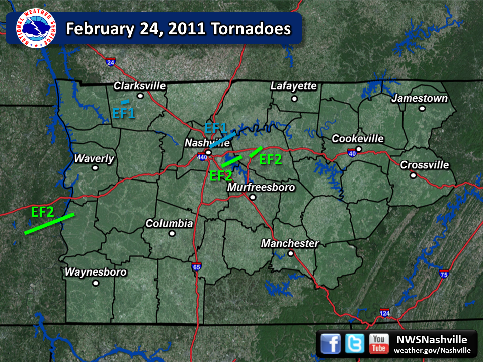
| February 24, 2011 Tornadoes | ||||||||
| # | Counties | Rating | Time (CST) | Length (miles) | Width (yards) | Fatalities | Injuries | |
| 1 | Carroll/Decatur/Perry | EF2/EF2/EF1 | 2043 | 16.8 | 400 | 0 | 0 | |
| 2 | Montgomery | EF1 | 2105 | 2.3 | 50 | 0 | 0 | |
| 3 | Davidson/Sumner/Wilson | EF1/EF0/EF0 | 2151 | 14.4 | 500 | 0 | 0 | |
| 4 | Davidson/Wilson | EF2 | 2202 | 7.5 | 100 | 0 | 0 | |
| 5 | Wilson | EF2 | 2214 | 8.0 | 150 | 0 | 2 | |
| Reports & Outlooks | |||
| SPC Outlooks | SPC Storm Reports | Local Storm Reports | Public Information Statements |
| EF2 Parsons Tornado | |
| Counties: | Carroll/Decatur/Perry |
| Time: | 8:43 PM CST |
| EF Scale: | EF-2 / EF-2 / EF-1 |
| Wind Speed Estimate (Perry County): | 105 MPH |
| Damage Path Length: | 16.8 miles |
| Damage Path Width: | 400 yards |
| Start Point: | 35.664287 -88.237006 |
| End Point: | 35.743031 -87.955254 |
| Fatalities: | 0 |
| Injuries | 0 |
| Damage: NWS Memphis found an EF-2 tornado touched down in Carroll County about 2 miles northwest of Parsons Tennessee and scattered damage was found through forest and pasture land with large trees uprooted and snapped. The tornado then continued northeast into Decatur County. Major damage was sustained to a mobile home in the Five Forks area. A large grain bin was tossed 50 yards and destroyed and there was minor damage to homes and trees in the Bible Hill area. Several tombstones were also overturned and damaged in Bible Hill. The most significant damage occurred on Blue Bird Circle at the Lick Creek Inlet. Eight homes sustained enough damage to render them uninhabitable along with damage to private boat docks and pontoon boats. A roof to a floating boat dock was lifted off of its foundation and tossed approximately one half mile across the inlet and destroyed. Damage to homes and businesses in Carroll and Decatur counties was estimated at 1.285 million dollars. The tornado then crossed the Tennessee River into Perry County and produced EF-1 damage. NWS Nashville personnel found hundreds of trees were snapped or uprooted. Several mobile homes and one old home had roofs blown off. |
|
| EF1 Woodlawn Tornado | |
| Counties: | Montgomery |
| Time: | 9:05 PM CST |
| EF Scale: | EF-1 |
| Damage Path Length: | 2.3 miles |
| Damage Path Width: | 50 yards |
| Start Point: | 36.5347 / -87.4549 |
| End Point: | 36.5375 / -87.4166 |
| Fatalities: | 0 |
| Injuries | 0 |
|
Damage: SHAMBURGER (2017): Despite a NWS storm survey being conducted with Montgomery County emergency management for this tornado, it is not included in official Storm Data, SPC, or NCDC records. This EF1 tornado with winds 90 to 100 mph touched down along York Road just south of the Woodlawn community. Intermittent damage continued 2.3 miles to the northeast. Dozens of trees were uprooted and snapped, and a house on Dotsonville Road lost part of its roof. |
|
| EF1 Lakewood Tornado | |
| Counties: | Davidson/Sumner/Wilson |
| Time: | 9:51 PM CST |
| EF Scale: | EF-1 / EF-0 / EF-0 |
| Damage Path Length: | 14.4 miles |
| Damage Path Width: | 500 yards |
| Start Point: | 36.19 / -86.77 |
| End Point: | 36.28 / -86.54 |
| Fatalities: | 0 |
| Injuries | 0 |
|
Damage: STORM DATA (Davidson County, Lakewood): A swath of thunderstorm wind damage, with a path length of just over one mile, and a width of about 500 yards, occurred in Lakewood. At least 100 large hardwood trees were uprooted with a few trees snapped, fallen trees damaged some roofs and vehicles, and some loss of shingles noted on dozens of house roofs. Three power poles were snapped and wood fences in the area were also blown down. STORM DATA (Sumner County): In south Hendersonville, a heavily forested subdivision experienced tree damage. At least 100 large hardwood trees were uprooted, including a few snapped. Trees that had fallen had damaged some roofs and vehicles. Some loss of shingles also noted on house roofs. NEWSPAPER REPORT (Wilson County): Emergency management reported numerous trees and power lines were blown down and several carports were destroyed on Saundersville Ferry Road, Weeping Elm Drive, and Noel Drive. SHAMBURGER (2015): Although the original NWS storm survey found this path of damage across Davidson, Sumner, and Wilson Counties to be thunderstorm wind damage, radar data and aerial imagery from Google Earth clearly indicates this damage was caused by an EF1 QLCS tornado. The tornado is estimated to have touched down along Cleveland Street 1.75 miles northeast of downtown Nashville, then moved rapidly northeast across east Nashville, the Opryland area, Neelys Bend, and Lakewood producing EF1 damage. Crossing Old Hickory Lake into far southern Hendersonville, the tornado caused EF0 damage before again moving across Old Hickory Lake into Wilson County, where additional EF0 damage to trees and homes occurred in the Saundersville Ferry Road area. The tornado dissipated into a severe downburst about 5.9 miles north-northwest of Mount Juliet. |
|
| EF2 Antioch Tornado | |
| Counties: | Davidson/Wilson |
| Time: | 10:02 PM CST |
| EF Scale: | EF-2 |
| Wind Speed Estimate: | 120 MPH |
| Damage Path Length: | 7.5 miles |
| Damage Path Width: | 100 yards |
| Start Point: | 36.087089 -86.6163 |
| End Point: | 36.120583 -86.48837 |
| Fatalities: | 0 |
| Injuries | 0 |
|
Damage: |
|
TBNA Radar: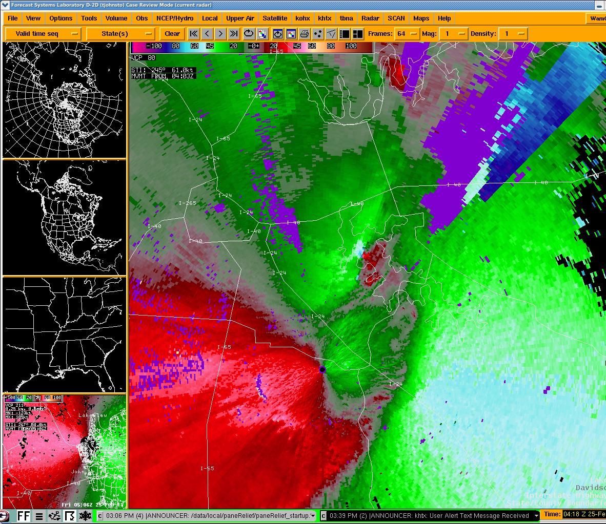 |
|
| EF2 Lebanon Tornado | |
| Counties: | Wilson |
| Time: | 10:14 PM CST |
| EF Scale: | EF-2 |
| Wind Speed Estimate: | 120 MPH |
| Damage Path Length: | 8 miles |
| Damage Path Width: | 150 yards |
| Start Point: | 36.118821 -86.417906 |
| End Point: | 36.183829 -86.299975 |
| Fatalities: | 0 |
| Injuries | 2 |
| Damage: PUBLIC INFORMATION STATEMENT NATIONAL WEATHER SERVICE NASHVILLE TN 345 PM CST FRI FEB 25 2011 ...SECOND TORNADO CONFIRMED NEAR LEBANON IN WILSON COUNTY... * THE INFORMATION IN THIS STATEMENT IS PRELIMINARY AND SUBJECT TO CHANGE PENDING FINAL REVIEW OF THE EVENT(S) AND PUBLICATION IN NWS STORM DATA. ...SUMMARY... A SECOND TORNADO SPUN UP JUST SOUTH OF CENTRAL PIKE ALONG GLADIEVILLE ROAD. DAMAGE CONTINUED NORTHEAST FOR 8 MILES WITH THE LAST EVIDENCE OF DAMAGE NEAR INTERSTATE 40 AND CUMBERLAND STREET SOUTH OF LEBANON. THE WILSON COUNTY EMERGENCY MANAGEMENT AGENCY ASSISTED THE NWS WITH THIS SURVEY. THE MOST SIGNIFICANT DAMAGE...EF2...OCCURRED BETWEEN FRANKLIN ROAD AND HIGHWAY 840. SEVERAL WAREHOUSE BUILDINGS SUFFERED SIGNIFICANT ROOF AND WALL DAMAGE...AND A CONSTRUCTION TRAILER WAS COMPLETELY DESTROYED WITH DEBRIS SPREAD OUT OVER HUNDREDS OF YARDS. A 500KV TVA HIGH TENSION METAL TRUSS TOWER WAS COMPLETELY BENT OVER. HUNDREDS OF HARDWOOD TREES WERE SNAPPED AND UPROOTED. THIS INFORMATION CAN ALSO BE FOUND ON OUR WEBSITE AT WEATHER.GOV/NASHVILLE. FOR REFERENCE...THE ENHANCED FUJITA SCALE CLASSIFIES TORNADOES INTO THE FOLLOWING CATEGORIES: EF0...WIND SPEEDS 65 TO 85 MPH. EF1...WIND SPEEDS 86 TO 110 MPH. EF2...WIND SPEEDS 111 TO 135 MPH. EF3...WIND SPEEDS 136 TO 165 MPH. EF4...WIND SPEEDS 166 TO 200 MPH. EF5...WIND SPEEDS GREATER THAN 200 MPH. $$ TOM JOHNSTONE/MICHAEL DAVIS NWS NASHVILLE |
|
TBNA Radar: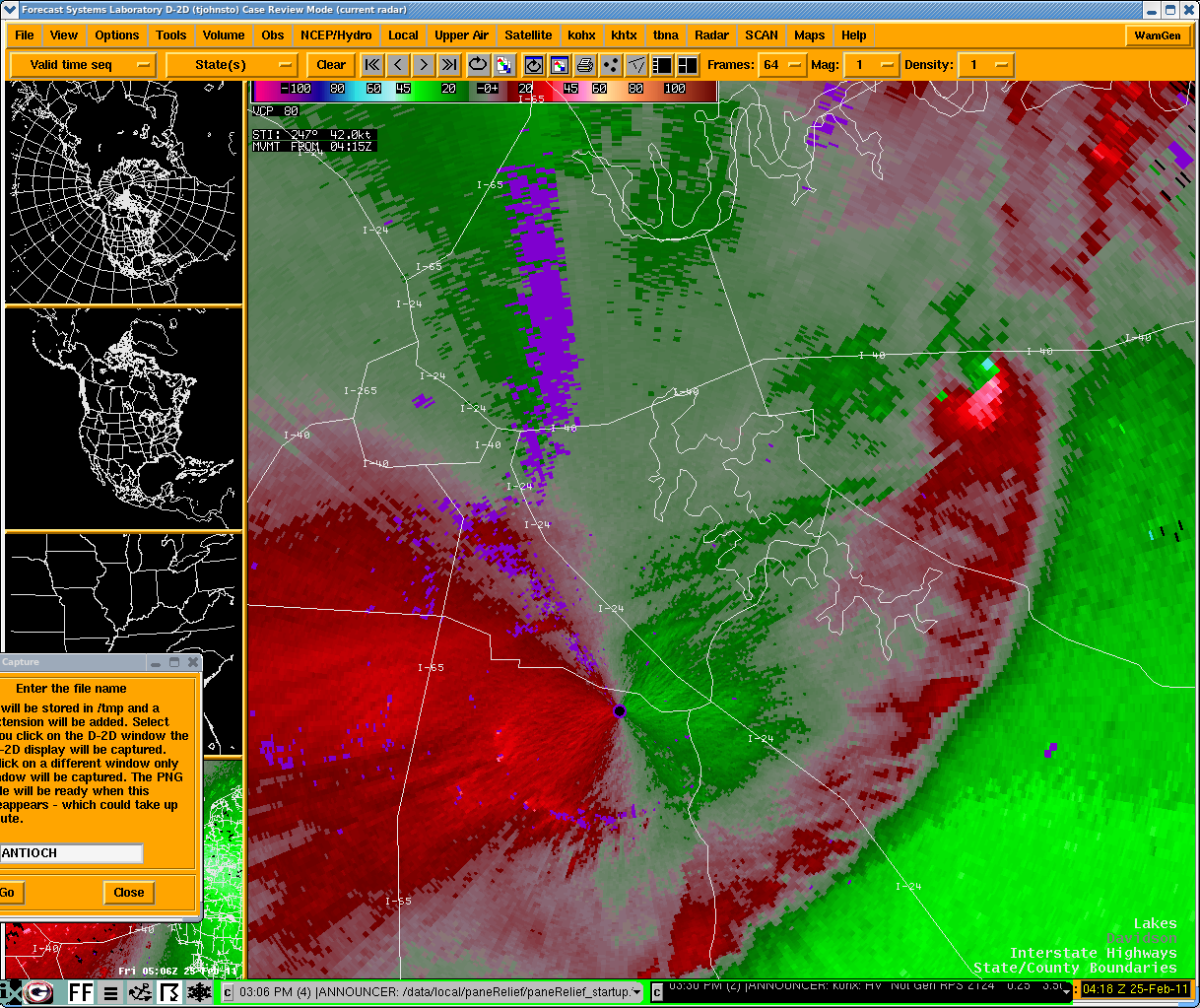 |
|


 Follow us on YouTube