| March 23, 2011 Tornadoes | ||||||||
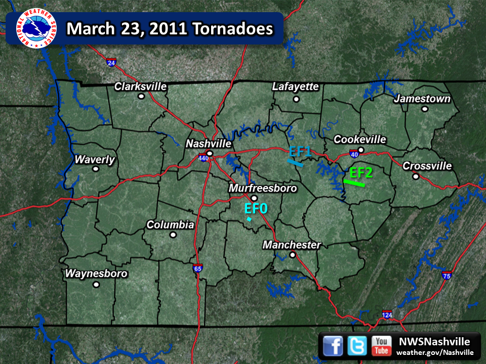
| # | Counties | Rating | Time (CST) | Length (miles) | Width (yards) | Fatalities | Injuries | |
| 1 | Wilson/Smith/Dekalb | EF1 | 1819 | 6.0 | 100 | 0 | 0 | |
| 2 | White | EF2 | 1854 | 9.0 | 100 | 0 | 0 | |
| 3 | Rutherford | EF0 | 1903 | 1.0 | 50 | 0 | 0 | |
| Reports & Outlooks | ||||
| SPC Outlooks | SPC Storm Reports | SPC Event Archive | Public Information Statements | |
| EF1 Watertown Tornado | |
| Counties: | Wilson/Smith/Dekalb |
| Time: | 6:19 PM CST |
| EF Scale: | EF1 |
| Wind Speed Estimate: | 100 MPH |
| Damage Path Length: | 6 Miles |
| Damage Path Width: | 100 Yards |
| Start Point: | 36.099 -86.093 |
| End Point: | 36.065 -86.001 |
| Fatalities: | 0 |
| Injuries: | 0 |
|
Damage: Damage consisted of hundreds of trees being uprooted or snapped along a nearly continuous path. Several homes suffered significant roof damage, along with a couple of barns and outbuildings being destroyed. The tornado clipped the far southwestern tip of Smith County as it moved into DeKalb County. The tornado moved across the north side of the town of Alexandria where tree and roof damage was noted. The last evidence of damage was along Lower Helton Road 2 miles east of Alexandria. Maximum wind speeds associated with this tornado were estimated to be around 100 mph. |
|
| EF2 Sparta Tornado | |
| Counties: | White |
| Time: | 6:54 PM CST |
| EF Scale: | EF2 |
| Wind Speed Estimate: | 115 MPH |
| Damage Path Length: | 9 Miles |
| Damage Path Width: | 100 Yards |
| Start Point: | 35.960 -85.639 |
| End Point: | 35.913 -85.490 |
| Fatalities: | 0 |
| Injuries: | 0 |
|
Damage: Damage began near the intersection of Indian Mound Road and Old Smithville Highway. Hundreds of trees were uprooted or snapped along a nearly continuous 9 mile path. Three homes had complete roof loss and a mobile home was completely destroyed with debris scattered over a large area. Around a dozen barns and outbuildings were destroyed. The last evidence of damage was just southwest of downtown Sparta on Iris Drive. Maximum wind speeds associated with this tornado were estimated to be around 115 mph. |
|
| EF0 Christiana Tornado | |
| Counties: | Rutherford |
| Time: | 7:03 PM CST |
| EF Scale: | EF0 |
| Wind Speed Estimate: | 80 MPH |
| Damage Path Length: | 1 Miles |
| Damage Path Width: | 50 Yards |
| Fatalities: | 0 |
| Injuries: | 0 |
|
Damage: Damaged occurred on Walnut Grove Road near U.S. Highway 231. Some trees were uprooted and a small portion of shingles were removed from a few homes. A couple of outbuildings were also damaged. Maximum wind speeds associated with this tornado were estimated to be around 80 mph. |
|


 Follow us on YouTube