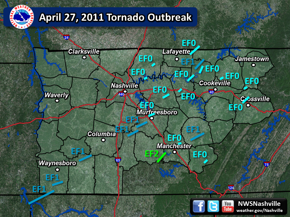
| April 27, 2011 Super Outbreak Tornadoes | ||||||||
| # | Counties | Rating | Time (CST) | Length (miles) | Width (yards) | Fatalities | Injuries | |
| 1 | Lauderdale AL/Wayne | EF1 | 0301 | 9.79 | 200 | 0 | 0 | |
| 2 | Wayne | EF1 | 0319 | 6.16 | 200 | 0 | 0 | |
| 3 | Lawrence | EF1 | 0350 | 7.11 | 300 | 0 | 1 | |
| 4 | Wilson | EF0 | 0423 | 3.00 | 50 | 0 | 0 | |
| 5 | Bedford/Rutherford/Marshall | EF1 | 0434 | 7.50 | 150 | 0 | 0 | |
| 6 | Sumner | EF0 | 0435 | 3.70 | 100 | 0 | 0 | |
| 7 | Rutherford | EF1 | 0443 | 9.90 | 500 | 0 | 0 | |
| 8 | Rutherford | EF0 | 0454 | 4.60 | 100 | 0 | 0 | |
| 9 | Moore/Bedford/Coffee | EF2 | 0513 | 4.17 | 100 | 0 | 0 | |
| 10 | Wilson | EF0 | 0513 | 4.50 | 100 | 0 | 0 | |
| 11 | Smith | EF0 | 0524 | 3.43 | 50 | 0 | 0 | |
| 12 | Macon/Clay/Allen KY | EF0 | 0529 | 5.96 | 100 | 0 | 0 | |
| 13 | Smith/Jackson | EF0 | 0531 | 6.73 | 200 | 0 | 0 | |
| 14 | Jackson | EF0 | 0539 | 4.38 | 100 | 0 | 0 | |
| 15 | Coffee | EF0 | 0540 | 1.67 | 50 | 0 | 0 | |
| 16 | Jackson/Clay | EF1 | 0541 | 9.70 | 500 | 0 | 0 | |
| 17 | Warren | EF1 | 0547 | 13.17 | 100 | 0 | 2 | |
| 18 | Overton | EF0 | 0612 | 1.96 | 50 | 0 | 0 | |
| 19 | Fentress | EF0 | 0643 | 0.42 | 50 | 0 | 0 | |
| 20 | Cumberland | EF0 | 0647 | 5.60 | 100 | 0 | 0 | |
| 21 | Grundy | EF0 | 1700 | 1.16 | 50 | 0 | 0 | |
| Overview | |
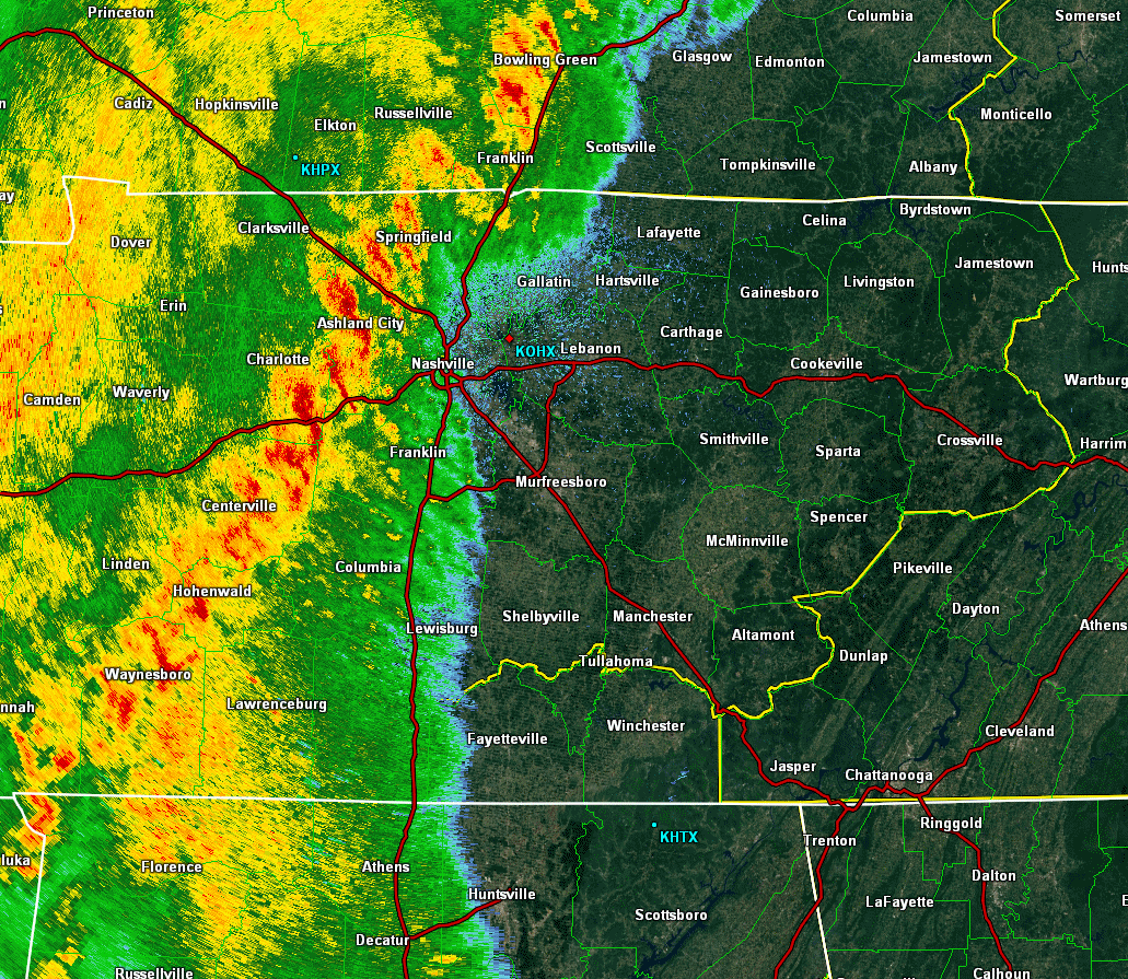
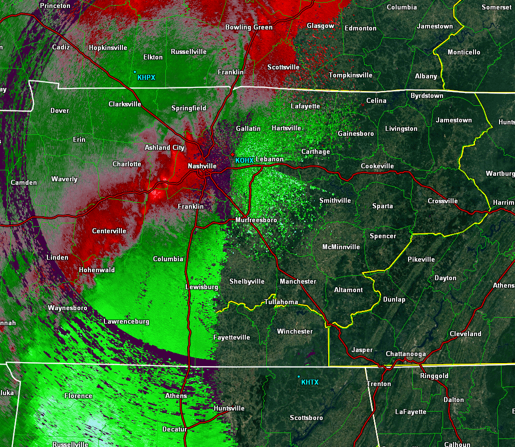
| After two days of active severe weather across Middle Tennessee on April 25 and 26, another powerful QLCS (Quasi-Linear Convective System), also known as a squall line, moved across the region during the late evening hours on April 26 into the early morning hours on April 27. This QLCS spawned nearly two dozen mainly weak tornadoes across Middle Tennessee, along with producing widespread wind damage and flash flooding. Thankfully, rain-cooled air from this QLCS kept the atmosphere stable across the Mid State the rest of the day, sparing Middle Tennessee from the devastating tornadoes that would strike Alabama and east Tennessee later that same afternoon and evening. Data on this tornado outbreak is from local storm reports, NWS storm surveys, radar imagery from OHX and HTX radars, satellite imagery available in Google Earth, and additional research conducted in 2015 and 2016 by Sam Shamburger, a lead forecaster at NWS Nashville. |
| Links | |||
| NWS Huntsville 4/27/2011 Page | NWS Birmingham 4/27/2011 Page | NWS Morristown 4/27/2011 Page | |
| NWS Memphis 4/27/2011 Page | NWS Jackson 4/27/2011 Page | NWS Atlanta 4/27/2011 Page | |
| Radar | |
| OHX Radar Base Reflectivity Loop 3AM - 8AM | OHX Radar Storm Relative Velocity Loop 3AM - 8AM |
| EF1 Lauderdale AL/Wayne TN Tornado | |
| Counties: | Lauderdale AL/Wayne TN |
| Time: | 3:01 AM CST |
| EF Scale: | EF1 |
| Damage Path Length: | 9.79 miles |
| Damage Path Width: | 200 yards |
| Fatalities: | 0 |
| Injuries | 0 |
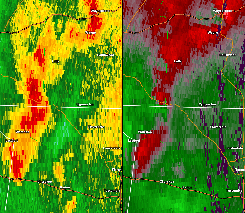
| Damage: STORM DATA (Lauderdale County AL): A tornado of EF-1 intensity produced peak wind speeds up to 110 mph. The tornado touched down along County Road 90, 1 mile north-northeast of Waterloo. Here, numerous trees were snapped on the hillside along County Roads 90 and 78. Two docks along Second Creek sustained damage. Just southeast of the intersection of County Roads 90 and 21, 3 residences sustained minor damage. The first home had its windows blown out on the upper floor. The second sustained shingle damage and had the rear wall of a garage blown out. The third had a portion of a garage picked up and thrown over the house about 75 yards. A brick was thrown through the back window of the residence. Numerous trees were snapped immediately to the southeast of this home. The tornado continued along County Road 90. Near the intersection of Lester Hollow Road, several large/wide trees were snapped off from 8 to 15 feet off the base. To the east along Lester Hollow Road, trees were knocked onto 3 homes. The tornado produced significant tree damage as it progressed northeastward. At the intersection of State Highway 20 and County Road 40, a building had 3 awnings blown off, with one being deposited across Highway 20. The tornado then tracked into a wooded area and moved into Tennessee. STORM DATA (Wayne County): This is the end of a tornado which affected Lauderdale County Alabama early on the morning of April 27th. Rated EF0. SHAMBURGER (2015): Radar data and aerial imagery from Google Earth indicate this tornado continued northeast out of Lauderdale County, Alabama and produced EF0 damage for approximately 0.77 miles across rural areas of southern Wayne County, blowing down dozens of trees in a narrow swath, before dissipating into a large downburst. This downburst blew down dozens of trees across areas of Bevis School Road and Barkley Branch Road before ending west of Morgan Road. The total path length from Lauderdale County into Wayne County, path width, time and location has been corrected based on radar data and the damage path on Google Earth aerial imagery. |
|
| Radar & Satellite: | |
 HTX Radar BR/SRV |
|
| EF1 Wayne County Tornado | |
| Counties: | Wayne |
| Time: | 3:19 AM CST |
| EF Scale: | EF1 |
| Damage Path Length: | 6.16 miles |
| Damage Path Width: | 200 yards |
| Fatalities: | 0 |
| Injuries | 0 |
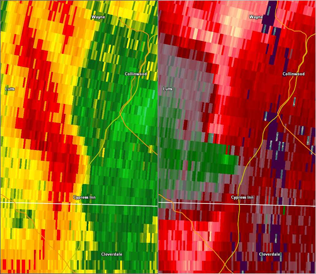
| Damage: STORM DATA: Trees and power lines were reported downed across southern portions of the county. SHAMBURGER (2015): This EF1 tornado, which was originally listed as thunderstorm wind damage in Storm Data, was added to the NWS Nashville database based on radar data and aerial imagery from Google Earth. This tornado began west of Simmental Lane about 3 miles northwest of Cypress Inn then moved rapidly northeast across Highway 915, Berry Road, Big Cypress Road, Natchez Trace Parkway, and Harper Cemetery Road before dissipating into a large downburst east of Spain Road. Thousands of trees were snapped and uprooted along the path in a convergent pattern with a few outbuildings were damaged, and the degree of tree damage warranted the EF1 rating. |
|
| Radar & Satellite: | |
 HTX Radar BR/SRV |
|
| EF1 Lawrence County Tornado | |
| Counties: | Lawrence |
| Time: | 3:50 AM CST |
| EF Scale: | EF1 |
| Damage Path Length: | 7.11 miles |
| Damage Path Width: | 300 yards |
| Fatalities: | 0 |
| Injuries | 1 |
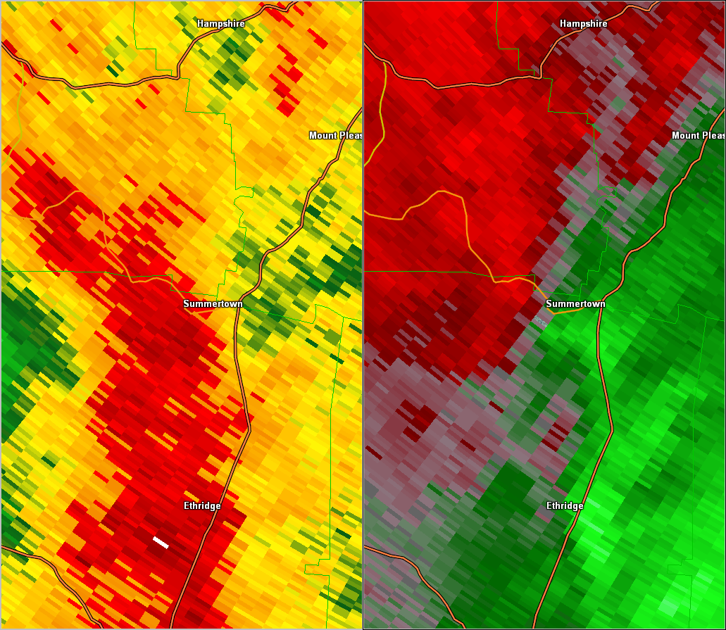
| Damage: STORM DATA: The tornado first touched down near the intersection of Gresham and Moore Roads and lifted near the intersections of State Highways 240 and U.S. Highway 43. Hundreds of trees were snapped and several building suffered damage. A man suffered minor injuries when part of his home on Gresham Road collapsed. SHAMBURGER (2015): NCDC and Storm Data erroneously list the time of this tornado as 450am instead of 350am. In addition, radar data and aerial imagery from Google Earth indicate the path length and width of this tornado is several miles longer than originally listed in Storm Data. This EF1 tornado first touched down north of Brier Hill Road then moved northeast across Oaks Road, Cummings Road, Highway 1819, Freedom Road and U.S. Highway 43 before lifting near the Maury County line. Hundreds of trees were snapped and several buildings suffered damage including a barn on Pleasant Garden Road. A man suffered minor injuries when part of his home on Grisham Road collapsed. |
|
| Radar & Satellite: | |
 OHX Radar BR/SRV |
|
| EF0 Wilson County Tornado | |
| Counties: | Wilson |
| Time: | 4:23 AM CST |
| EF Scale: | EF0 |
| Damage Path Length: | 3.00 miles |
| Damage Path Width: | 50 yards |
| Fatalities: | 0 |
| Injuries | 0 |
| Damage: STORM DATA: At the Boxwell Reservation, the roof was taken off of the main dining hall. SHAMBURGER (2015): This EF0 tornado, which was originally listed as thunderstorm wind damage in Storm Data, was added to the NWS Nashville database based on radar data and aerial imagery from Google Earth. This tornado began on Old Hickory Lake then moved northeast across Gambill Cove Tubbs Road and the Boxwell Boy Scout Reservation before lifting east of Woods Ferry Road. Numerous trees were blown down in all directions, and the roof was blown off of the main dining hall at the Boxwell Boy Scout Reservation. |
|
| Radar & Satellite: | |
 OHX Radar BR/SRV |
|
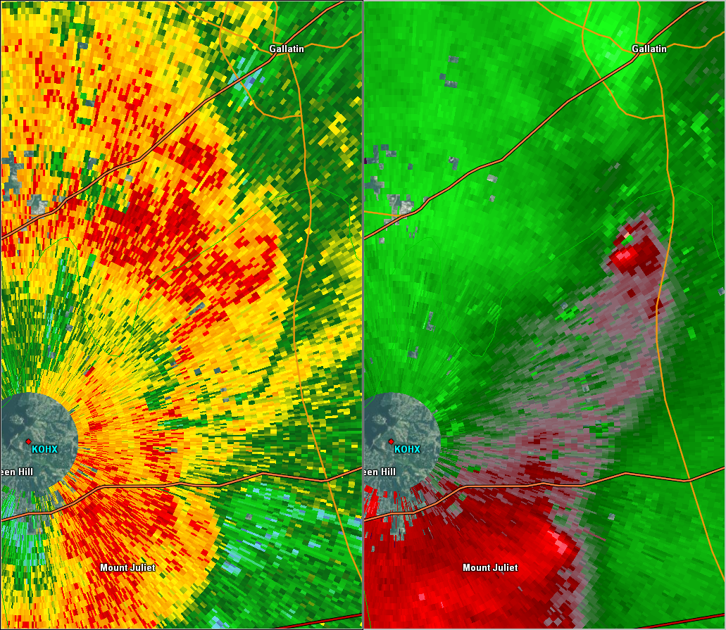
| EF1 Marshall/Bedford/Rutherford County Tornado | |
| Counties: | Marshall/Bedford/Rutherford |
| Time: | 4:34 AM CST |
| EF Scale: | EF1 |
| Damage Path Length: | 7.50 miles |
| Damage Path Width: | 150 yards |
| Fatalities: | 0 |
| Injuries | 0 |
| Damage: STORM DATA: An EF1 tornado with maximum winds 90 to 100 mph touched down around 540 am in northeast Marshall county. Damage began just west of the intersection of U.S. Highway 31a and Thick Road. The damage path was approximately 3 miles long. Maximum path width was 100 yards. Hundreds of trees were snapped or uprooted and several homes suffered roof damage. SHAMBURGER (2015): Radar data and aerial imagery from Google Earth indicate this tornado in northern Marshall County had a much longer path than previously indicated, and the path length, width, time and location of this tornado were adjusted based on radar data and the damage path on Google Earth aerial imagery. The tornado initially touched down along Thick Road south of Sweeney Lane. Dozens of trees were snapped or uprooted and several homes suffered minor roof damage as the tornado moved rapidly northeast across Highway 31A one-half mile south of Beasley Road. The tornado entered far southern Rutherford County out of Marshall County and crossed Highway 99 and Rigsby Road where several trees were blown down. A few more trees were blown down as the tornado moved across the extreme northwest corner of Bedford County. Several homes had minor roof and siding damage and numerous trees were snapped or uprooted as the tornado moved back into Rutherford County from Bedford County and crossed Highway 41 just north of the Rutherford/Bedford County line. The tornado lifted after crossing Bunker Hill Road. |
|
| Radar & Satellite: | |
 OHX Radar BR/SRV |
|
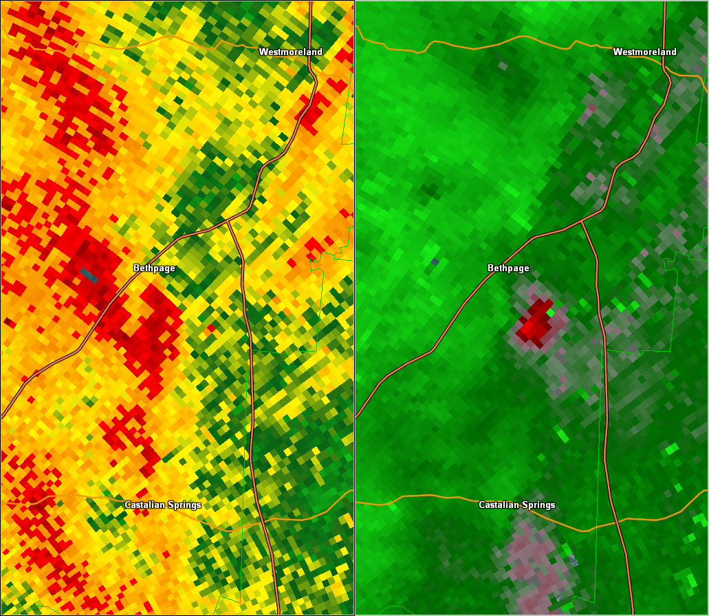
| EF0 Sumner County Tornado | |
| Counties: | Sumner |
| Time: | 4:35 AM CST |
| EF Scale: | EF0 |
| Damage Path Length: | 3.70 miles |
| Damage Path Width: | 100 yards |
| Fatalities: | 0 |
| Injuries | 0 |
| Damage: STORM DATA: Homes were damaged and trees were blown down in the Bethpage area. Specific details concerning type of damage and associated costs of this damage to the homes were unknown. SHAMBURGER (2015): This EF0 tornado, which was originally listed as thunderstorm wind damage in Storm Data, was added to the NWS Nashville database based on radar data and aerial imagery from Google Earth. This tornado touched down along Shiloh Road at Sideview Road in Bethpage and moved east then northeast across Rogana Road, Alexander Lane, and Rock Springs Road before ending north of Chipman Road. A few homes suffered minor roof and exterior damage and one old barn was heavily damaged. Dozens of trees were blown down in all directions along the narrow path. |
|
| Radar & Satellite: | |
 OHX Radar BR/SRV |
|
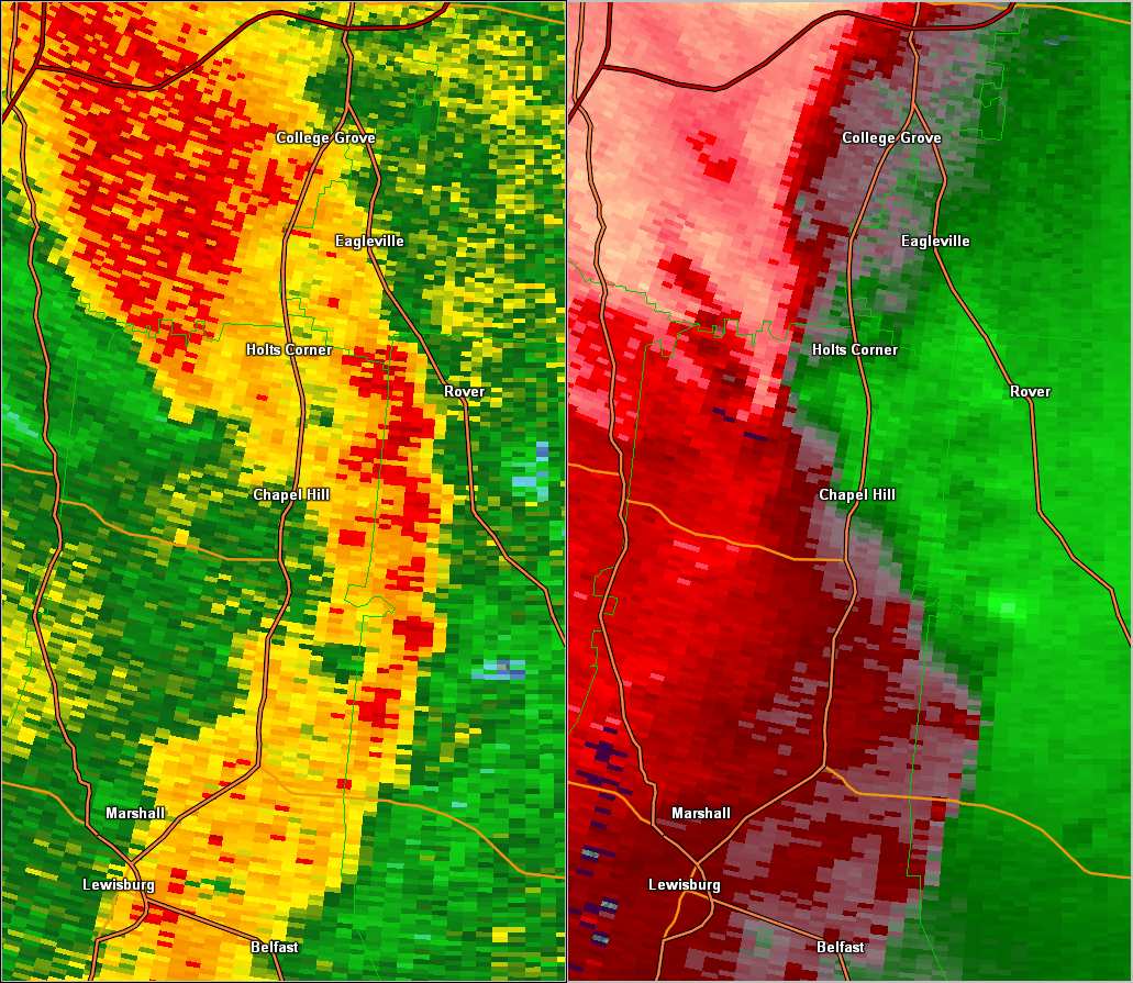
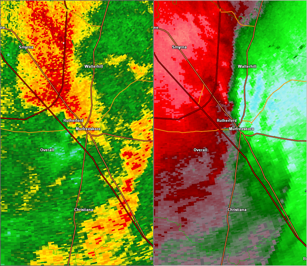
| EF1 Rutherford County Tornado | |
| Counties: | Rutherford |
| Time: | 4:43 AM CST |
| EF Scale: | EF1 |
| Damage Path Length: | 9.90 miles |
| Damage Path Width: | 500 yards |
| Fatalities: | 0 |
| Injuries | 0 |
| Damage: STORM DATA (near Rockvale): Numerous trees were uprooted near Rockvale by an EF-0 tornado with peak winds around 75 mph. STORM DATA (County Place subdivision west of Murfreesboro): A tornado touched down in the Country Park Subdivision just off State Highway 96. This was a brief tornado that uprooted several trees and snapped off others. Winds are estimated at 75 mph. SHAMBURGER (2015): Although NWS Storm Surveys originally determined two separate brief tornado touchdowns occurred near Rockvale and west of Murfreesboro, radar data and high-resolution satellite imagery from Google Earth indicate these were both part of the same large, strong EF1 tornado. This tornado actually touched down south of the Rocky Glade Road and Hill Road intersection about 3.5 miles northeast of Eagleville where a few trees were blown down. The tornado quickly intensified and blew down hundreds of trees and large swaths of forests in a convergent pattern from Morgan Road northeast across South Windrow Road and Snail Shell Cave Road, and the degree of tree damage in this area warranted the EF1 rating. The tornado weakened but still blew down dozens of trees as it continued northeast across Overall Creek Road, Windrow Road, Kingwood Lane, Veterans Parkway and Rucker Lane. Several homes also suffered minor roof damage in the Country Place subdivision as well as along Antebellum Drive, Westview Drive, and Wellington Place. The tornado lifted near St. Andrews Drive. The time, location, path length, path width, and EF-scale rating for this tornado have all been corrected based on the high-resolution satellite imagery from Google Earth and radar data. |
|
| Radar & Satellite: | |
 OHX Radar BR/SRV |
|
| EF0 Rutherford County Tornado | |
| Counties: | Rutherford |
| Time: | 4:54 AM CST |
| EF Scale: | EF0 |
| Damage Path Length: | 4.60 miles |
| Damage Path Width: | 100 yards |
| Fatalities: | 0 |
| Injuries | 0 |
| Damage: STORM DATA: Roof damage and siding damage occurred to houses near Haynes Drive. Damage occurred in the Jamison Place Subdivision. This included shingles coming of several homes, the top of many trees being broken off, and several fences being blown down. In the Regent Wood area, several trees were downed, power poles were damaged, and some structures also received roof damage. Specific details concerning the roofs of the structures damaged and associated costs were unknown. SHAMBURGER (2015): This EF0 tornado, which was originally listed as thunderstorm wind damage in Storm Data, was added to the NWS Nashville database based on radar data and aerial imagery from Google Earth. This tornado touched down in the Stones River National Battlefield in northwest Murfreesboro then moved rapidly northeast across the north side of Murfreesboro before lifting near Compton Road. Numerous homes suffered minor roof and siding damage along the path, including along Haynes Drive, Regenwood Drive, Jamison Place, Tower Drive and Highway 231. Dozens of trees were also snapped or uprooted in all directions, fences were blown down, and several power poles and lines were knocked down along the path. |
|
| Radar & Satellite: | |
 OHX Radar BR/SRV |
|
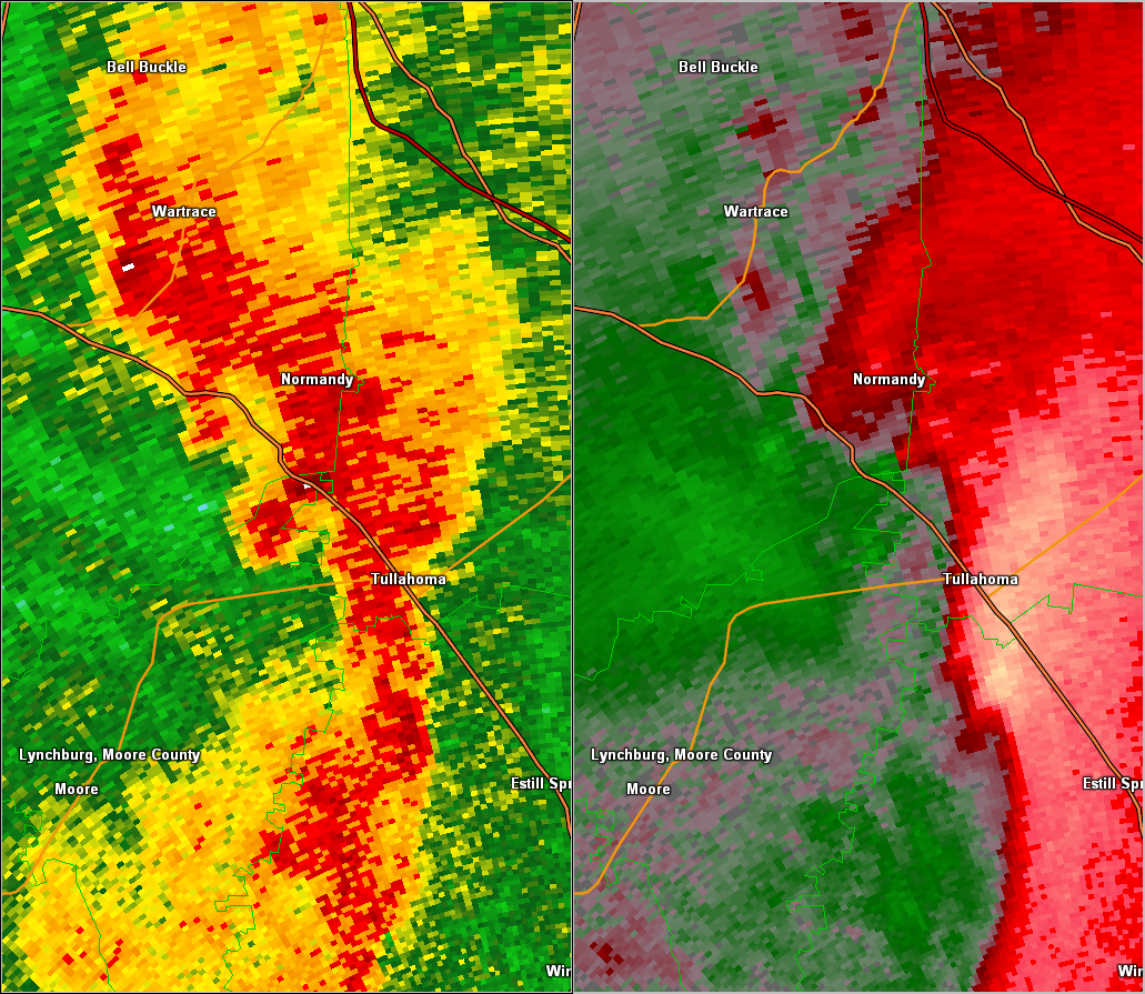
| EF2 Moore/Bedford/Coffee County Tornado | |
| Counties: | Moore/Bedford/Coffee |
| Time: | 5:13 AM CST |
| EF Scale: | EF2 |
| Damage Path Length: | 4.17 miles |
| Damage Path Width: | 100 yards |
| Fatalities: | 0 |
| Injuries | 0 |
| Damage: STORM DATA: A tornado of EF2 intensity produced peak winds speeds up to 115 mph. The tornado touched down along Motlow College Road just southwest of U.S. Highway 41A. The tornado destroyed at least one mobile home on Starbow Lane, rolled others off their foundations, and snapped and uprooted several trees. The tornado also damaged a church on Carr Creek Road. The tornado then moved into extreme southeast Bedford County as an EF1 tornado with maximum winds 90 to 100 mph around 615 am. Damage was centered along Magnolia Lane and Winding Way Road. Hundreds of trees were snapped along the path. The tornado then moved into Coffee County producing EF0 damage before lifting east of Cascade Hollow Road. SHAMBURGER (2015): NCDC and Storm Data incorrectly omit the Coffee County portion of this tornado, which was included in this entry. Based on aerial imagery from Google Earth and radar data, the total path length for this tornado across Moore, Bedford, and Coffee Counties was 4.17 miles. |
|
| Radar & Satellite: | |
 HTX Radar BR/SRV |
|
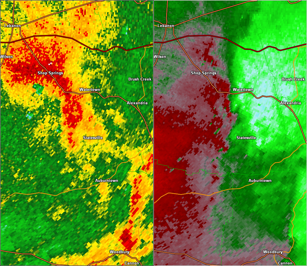
| EF0 Wilson County Tornado | |
| Counties: | Wilson |
| Time: | 5:13 AM CST |
| EF Scale: | EF0 |
| Damage Path Length: | 4.50 miles |
| Damage Path Width: | 100 yards |
| Fatalities: | 0 |
| Injuries | 0 |
| Damage: STORM DATA: Near State Highway 267, several roofs of structures received damage, trees were downed, and a barn was destroyed. Specific details concerning the type of structures that received roof damage were unknown. SHAMBURGER (2015): This EF0 tornado, which was originally listed as thunderstorm wind damage in Storm Data, was added to the NWS Nashville database based on radar data and aerial imagery from Google Earth. This tornado began near Griffin Hollow Road around 4.5 miles southwest of Watertown then moved northeast across Bug Hollow Road and Smith Hollow Road blowing down dozens of trees. Several homes received minor roof damage and a barn was destroyed along Highway 267. The tornado continued northeast across Patton Hollow Road, Fite Road and Neal Road blowing down dozens of more trees before lifting. |
|
| Radar & Satellite: | |
 OHX Radar BR/SRV |
|
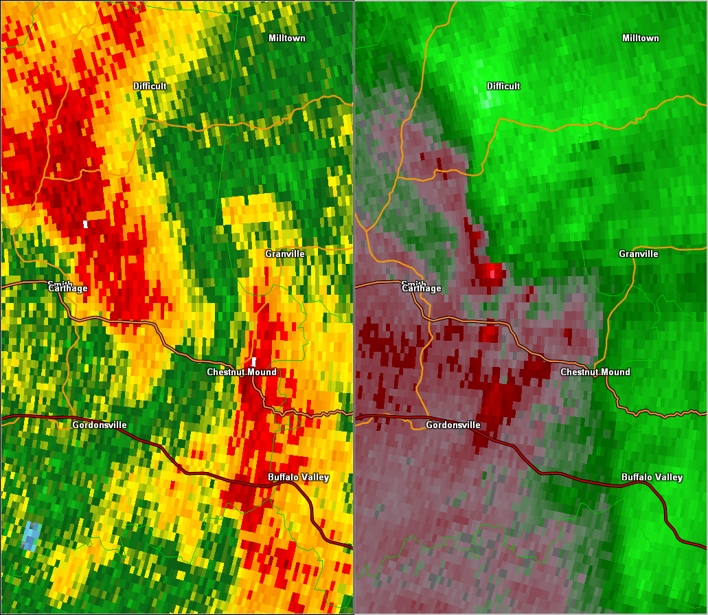
| EF0 Smith County Tornado | |
| Counties: | Smith |
| Time: | 5:24 AM CST |
| EF Scale: | EF0 |
| Damage Path Length: | 3.43 miles |
| Damage Path Width: | 50 yards |
| Fatalities: | 0 |
| Injuries | 0 |
| Damage: STORM DATA: An EF0 tornado began along New Middleton Rd, crossed Interstate 40, then lifted before reaching State Highway 53 south of Carthage. Hundreds of trees were snapped or uprooted. |
|
| Radar: | |
 OHX Radar BR/SRV |
|
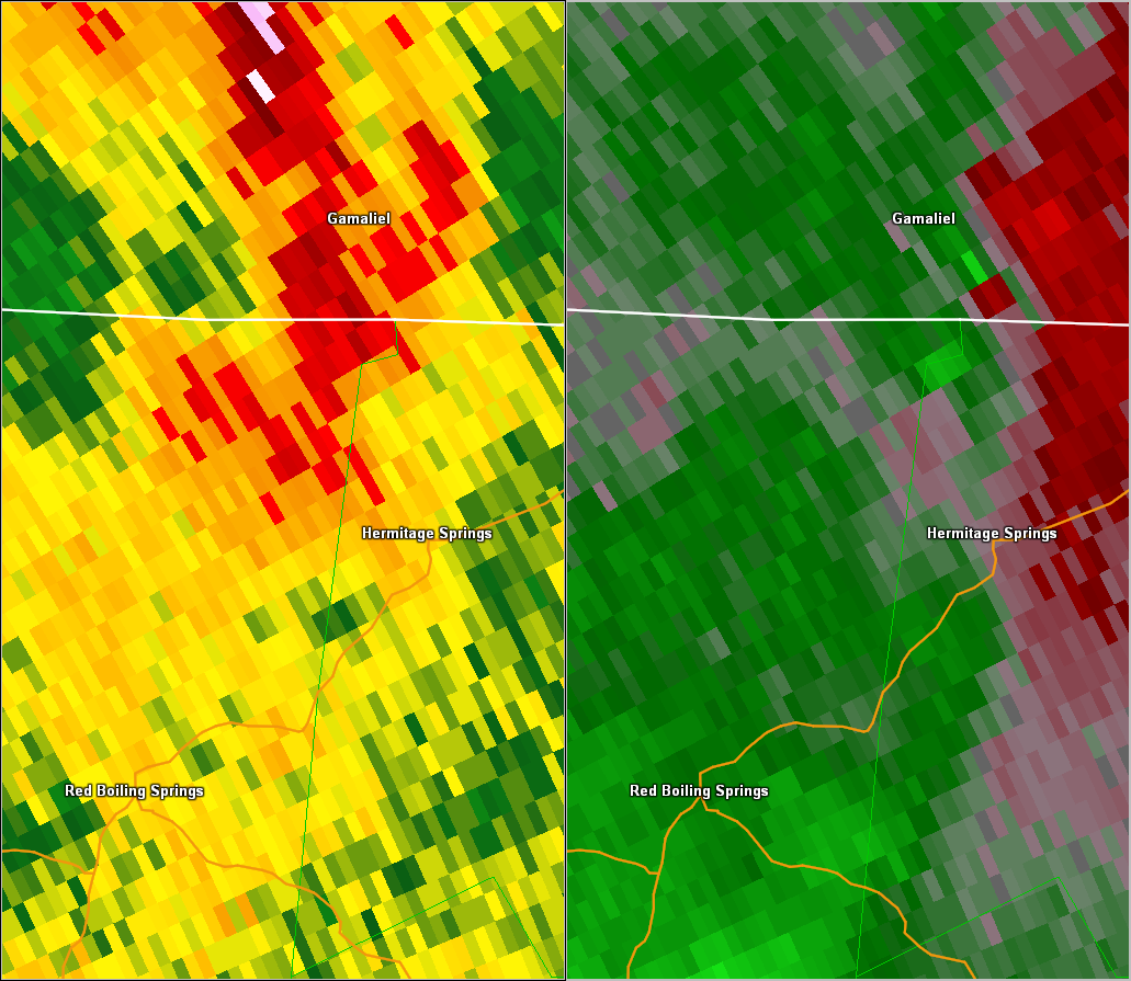
| EF0 Macon TN/Clay TN/Allen KY County Tornado | |
| Counties: | Macon TN/Clay TN/Allen KY |
| Time: | 5:29 AM CST |
| EF Scale: | EF0 |
| Damage Path Length: | 5.96 miles |
| Damage Path Width: | 100 yards |
| Fatalities: | 0 |
| Injuries | 0 |
| Damage: SHAMBURGER (2015): This EF0 tornado, which is not listed in official NCDC or Storm Data records, was added to the NWS Nashville database based on radar data and aerial imagery from Google Earth. This tornado touched down in far northeast Macon County between Langford Road and Highway 56, then moved northeast crossing Gamaliel Road near Winklers Road. At least four barns and other outbuildings were destroyed and dozens of trees were blown down in all directions as the tornado continued northeast across Pickett Road just to the east of Highway 56. Two more barns were damaged along Highway 56 west of Green Road, two older cinder block outbuildings lost parts of their roofs along Highway 56 east of Green Road, and dozens of more trees were blown down. The tornado then clipped the extreme northwest corner of Clay County blowing down several more trees. The tornado moved into Allen County, KY out of Clay County and continued northeast, crossing Howard Road and Clementsville Road before destroying several more barns and outbuildings east of Highway 63 and blowing down numerous trees. The tornado lifted north of Sugar Grove Road and east of Highway 63. |
|
| Radar & Satellite: | |
 OHX Radar BR/SRV |
|
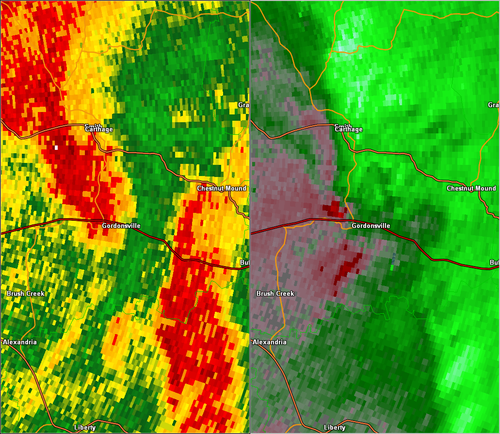
| EF0 Smith/Jackson County Tornado | |
| Counties: | Smith/Jackson |
| Time: | 5:31 AM CST |
| EF Scale: | EF0 |
| Damage Path Length: | 6.73 miles |
| Damage Path Width: | 200 yards |
| Fatalities: | 0 |
| Injuries | 0 |
| Damage: SHAMBURGER (2015): This EF0 tornado, which is not listed in official NCDC or Storm Data records, was added to the NWS Nashville database based on radar data and aerial imagery from Google Earth. This tornado touched down on Cordell Hull Lake east of Carthage in Smith County, then moved northeast across McClures Bend and Sullivans Bend into Jackson County before lifting along Brooks Bend Lane. Dozens of trees were snapped and uprooted in all directions along the path, and one old barn was destroyed. |
|
| Radar & Satellite: | |
 OHX Radar BR/SRV |
|
| EF0 Jackson County Tornado | |
| Counties: | Jackson |
| Time: | 5:39 AM CST |
| EF Scale: | EF0 |
| Damage Path Length: | 4.38 miles |
| Damage Path Width: | 100 yards |
| Fatalities: | 0 |
| Injuries | 0 |
| Damage: SHAMBURGER (2015): This EF0 tornado, which is not officially listed in NCDC or Storm Data, was added to the NWS Nashville database based on radar data and aerial imagery from Google Earth. This EF0 tornado began north of Highway 85/262 and moved north-northeast across Shed Forkum Road, West Cubb Road, Cubb Lane, Cub Creek Road, and Hensley Creek Lane before lifting north of Riley Creek Road. Dozens of trees were blown down in all directions along the narrow path. |
|
| Radar & Satellite: | |
 OHX Radar BR/SRV |
|
| EF0 Coffee County Tornado | |
| Counties: | Coffee |
| Time: | 5:40 AM CST |
| EF Scale: | EF0 |
| Damage Path Length: | 1.67 miles |
| Damage Path Width: | 50 yards |
| Fatalities: | 0 |
| Injuries | 0 |
| Damage: STORM DATA: An EF0 tornado with maximum winds 70 to 80 mph briefly touched down around 645 am in northeast Coffee County. Aamage was noted along Swann and Rock Roads. The damage path was around 1 mile long and 50 yds wide. SHAMBURGER (2015): NCDC incorrectly lists the path of this tornado, which was corrected based on radar data and aerial imagery from Google Earth. |
|
| Radar: | |
 HTX Radar BR/SRV |
|
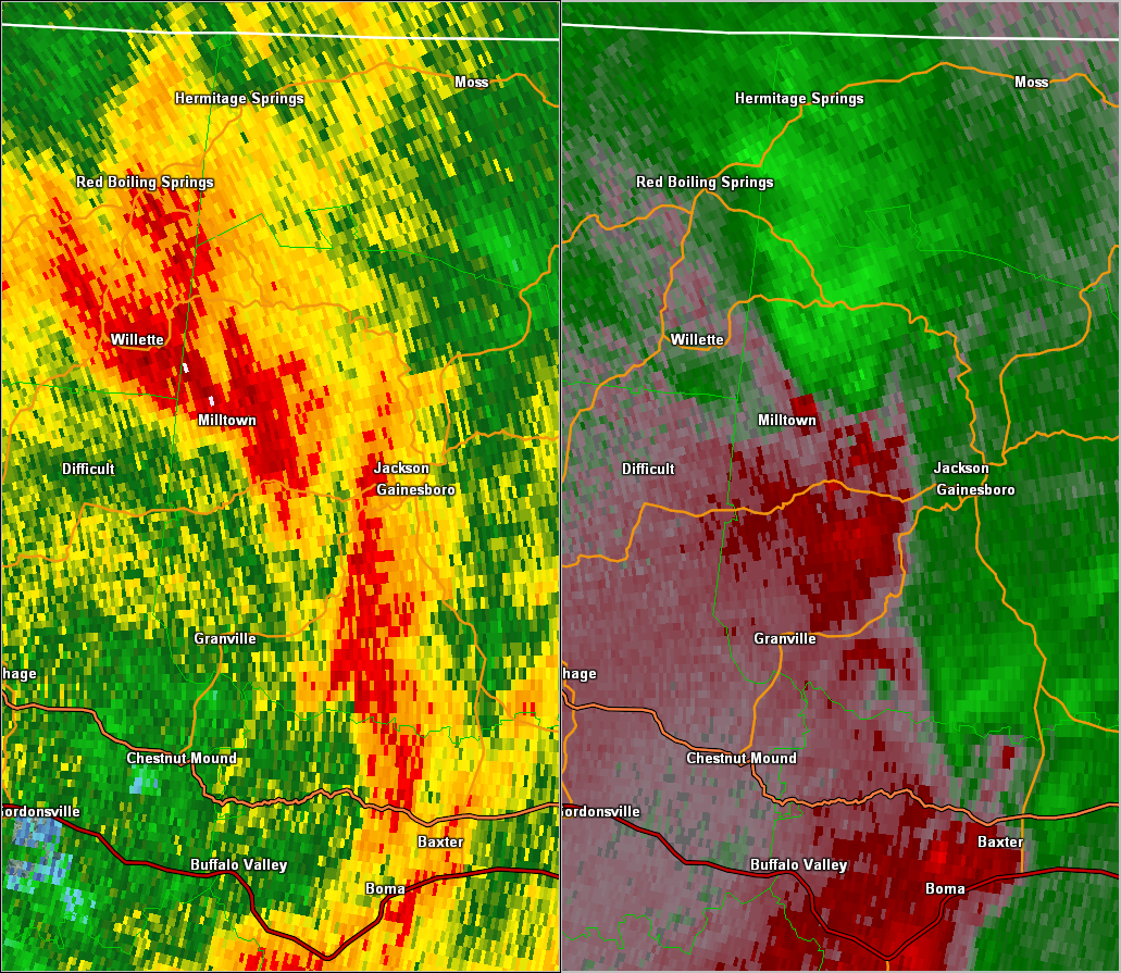
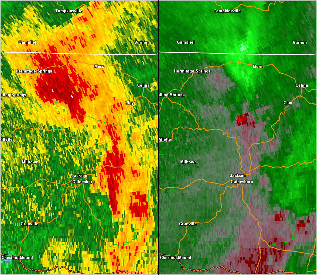
| EF1 Jackson/Clay County Tornado | |
| Counties: | Jackson/Clay |
| Time: | 5:41 AM CST |
| EF Scale: | EF1 |
| Damage Path Length: | 9.70 miles |
| Damage Path Width: | 500 yards |
| Fatalities: | 0 |
| Injuries | 0 |
| Damage: STORM DATA: Thousands of trees were snapped or uprooted in a narrow path from along State Highway 56 near the South Fork Road intersection northeast to State Highway 53 just south of the Clay County line. Maximum wind speeds were near 100 mph. SHAMBURGER (2015): The time, path length, path width and narrative for this tornado were corrected based on radar data and aerial imagery from Google Earth. This large, strong EF1 tornado snapped or uprooted thousands of trees from East Fork Road northeast across Haydenburg Road and Hunting Creek Road before crossing State Highway 56 just east of the South Fork Road intersection. The tornado continued northeast moving across Pine Lick Road and State Highway 135 before lifting in far southern Clay County. Maximum wind speeds were near 100 mph. |
|
| Radar & Satellite: | |
 OHX Radar BR/SRV |
|
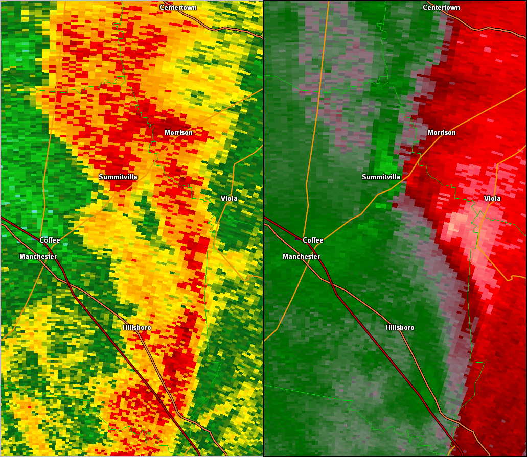
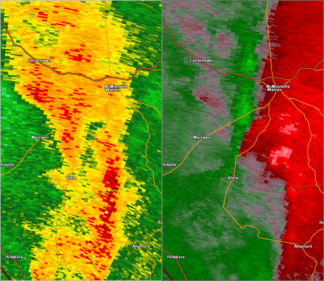
| EF1 Warren County Tornado | |
| Counties: | Warren |
| Time: | 5:47 AM CST |
| EF Scale: | EF1 |
| Damage Path Length: | 13.17 miles |
| Damage Path Width: | 100 yards |
| Fatalities: | 0 |
| Injuries | 2 |
| Damage: STORM DATA: An EF1 tornado with maximum winds 105 to 110 mph affected Warren County beginning around 650 am. Damage began northwest of Viola on State Highway 287. The damage path then followed State Highway 108. The last evidence of damage was approximately 3 miles southeast of McMinnville. SHAMBURGER (2015): NCDC and Storm Data incorrectly list the time and path location of this tornado, which were corrected based on radar data and aerial imagery from Google Earth. In addition, NCDC and Storm Data erroneously omit the 2 injuries that resulted from a mobile home being overturned on Viola Road in this tornado, and they were added into this entry. This tornado touched down along Highway 287 northwest of Viola and moved northeast along Viola Road. Numerous trees and power lines were blown down, and a mobile home was overturned and destroyed along Viola Road between Grove Road and White Hall Road, where the 2 people were injured. The tornado continued northeast up and down a 1,000 foot mountain with scattered trees being blown down intermittently. Moving across Highway 56 and Byars Road, the tornado continued blowing down trees before lifting near Myers Cove Road approximately 6 miles southeast of McMinnville. |
|
| Radar & Satellite: | |
 HTX Radar BR/SRV |
|
| EF0 Overton County Tornado | |
| Counties: | Overton |
| Time: | 6:12 AM CST |
| EF Scale: | EF0 |
| Damage Path Length: | 1.96 miles |
| Damage Path Width: | 50 yards |
| Fatalities: | 0 |
| Injuries | 0 |
| Damage: STORM DATA: An EF0 tornado with maximum wind speeds between 75 and 80 mph crossed Highway 111 near the Rickman Community. Dozens of trees were snapped or uprooted. Some of the trees fell on homes and vehicles. SHAMBURGER (2015): NCDC and Storm Data incorrectly list this tornado as occurring in Jackson County, and it was corrected to Overton County in this entry. The time of the tornado was also adjusted based on radar data. |
|
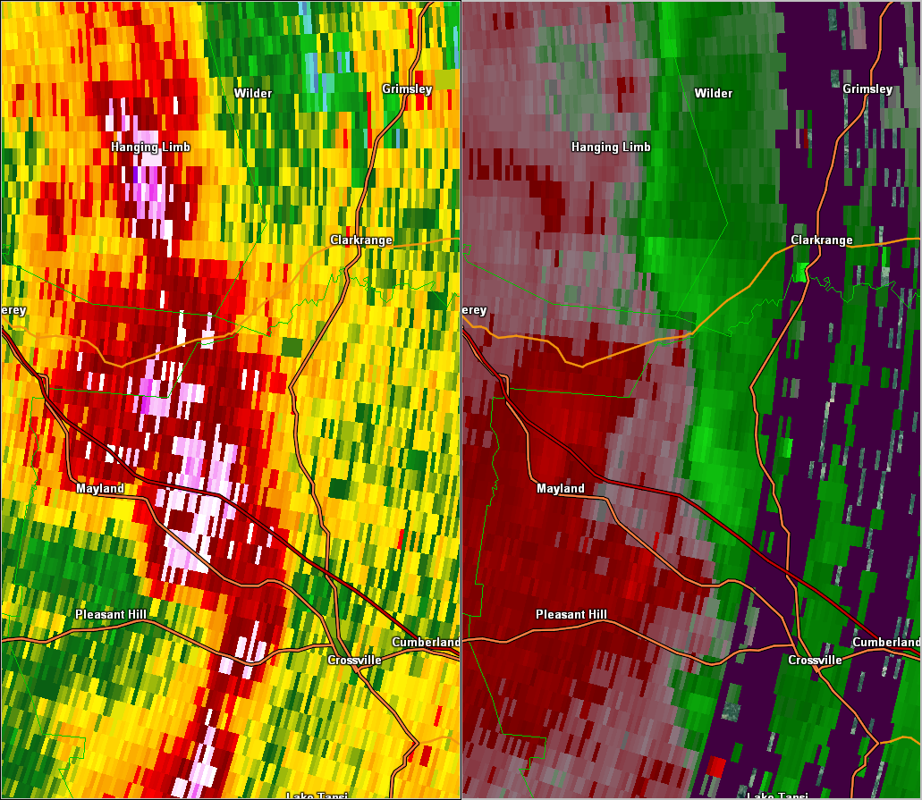
| EF0 Fentress County Tornado | |
| Counties: | Fentress |
| Time: | 6:43 AM CST |
| EF Scale: | EF0 |
| Damage Path Length: | 0.42 miles |
| Damage Path Width: | 50 yards |
| Fatalities: | 0 |
| Injuries | 0 |
| Damage: STORM DATA: Just off of State Highway 62 between Clarkrange and Monterey, about 3/4 mile east of the Putnam County line, several trees were snapped off, uprooted, or twisted. Minor structural damage also occurred. Specific details concerning what type of structure sustained damage and associated costs were unknown. SHAMBURGER (2015): Despite a NWS storm survey being conducted that determined this damage was an EF0 tornado, NCDC and Storm Data erroneously list this event as thunderstorm wind damage. This tornado has been added to the NWS Nashville database, with the time, location, path length, path width, and EF-scale rating taken from radar data, Google Earth aerial imagery, and the NWS storm survey assessment |
|
 OHX Radar BR/SRV |
|
| EF0 Cumberland County Tornado | |
| Counties: | Cumberland |
| Time: | 6:47 AM CST |
| EF Scale: | EF0 |
| Damage Path Length: | 5.60 miles |
| Damage Path Width: | 100 yards |
| Fatalities: | 0 |
| Injuries | 0 |
| Damage: STORM DATA: An EF-0 tornado with maximum winds 70 to 80 mph touched down near the intersection of Pomona Road and U.S Highway 70N. Damage continued northeast approximately 4.5 miles to near the intersection of Potato Farm Road and U.S Highway 127. Numerous trees were snapped and twisted along the 50 to 100 yard wide path. |
|
| EF0 Grundy County Tornado | |
| Counties: | Grundy |
| Time: | 5:00 PM CST |
| EF Scale: | EF0 |
| Damage Path Length: | 1.16 miles |
| Damage Path Width: | 50 yards |
| Fatalities: | 0 |
| Injuries | 0 |
| Damage: STORM DATA: An EF0 tornado with maximum winds 70 to 80 mph briefly touched down around 6 pm in Grundy County. Initial damage was noted 3 miles southeast of Altamont along Fletcher Strip Road. The damage path was around 1 mile long and 50 yds wide. SHAMBURGER (2015): Even though a NWS storm survey was conducted for this tornado, it is erroneously omitted from NCDC and Storm Data records. |
|


 Follow us on YouTube