| February 20, 2014 Severe Weather | |||
 |
|||
| Overview | |
|
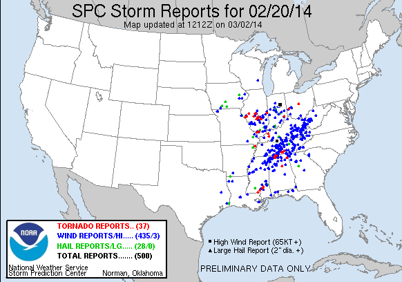
A large severe weather outbreak affected Middle Tennessee and much of the surrounding region during the late afternoon and evening hours on Thursday, February 20, 2014. A broken line of severe thunderstorms known as a QLCS (quasi-linear convective system), or more commonly called a squall line, developed across western Tennessee during the afternoon hours on February 20th, then raced across Middle Tennessee during the evening hours before moving east of the region around midnight. This QLCS brought widespread and damaging straight-line winds (downbursts) to nearly every county in Middle Tennessee, with over 70 reports of damage to trees, power lines, and buildings. Forecasters at the National Weather Service in Nashville, along with staff at the Storm Prediction Center in Norman, Oklahoma, had been monitoring for the potential of severe weather across Middle Tennessee on February 20th up to 5 days in advance. A strong upper level trough was forecast to move across the region during the afternoon and evening, which would provide strong wind shear throughout the atmosphere favorable for severe thunderstorms. Strong south winds of 20 to 30 mph with gusts up to 45 mph were also expected, which would bring warm, humid air northward from the Gulf of Mexico into the region, providing weak to moderate levels of atmospheric instability also favorable for thunderstorms to become severe. The combination of strong wind shear and weak to moderate instability was expected to fuel a line of severe thunderstorms with potentially widespread damaging winds and a few tornadoes. |
| Reports & Outlooks | |||
| SPC Storm Reports | SPC Event Archive | Local Storm Reports | Public Information Statements |
| EF1 Coffee County Tornado | |
| Counties: | Coffee |
| Time: | 1029-1030 PM |
| Wind Speed Estimate: | 90 MPH |
| Damage Path Length: | 1.2 miles |
| Damage Path Width: | 250 yards |
|
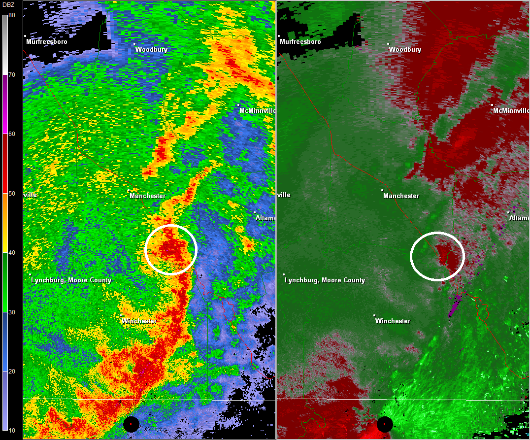
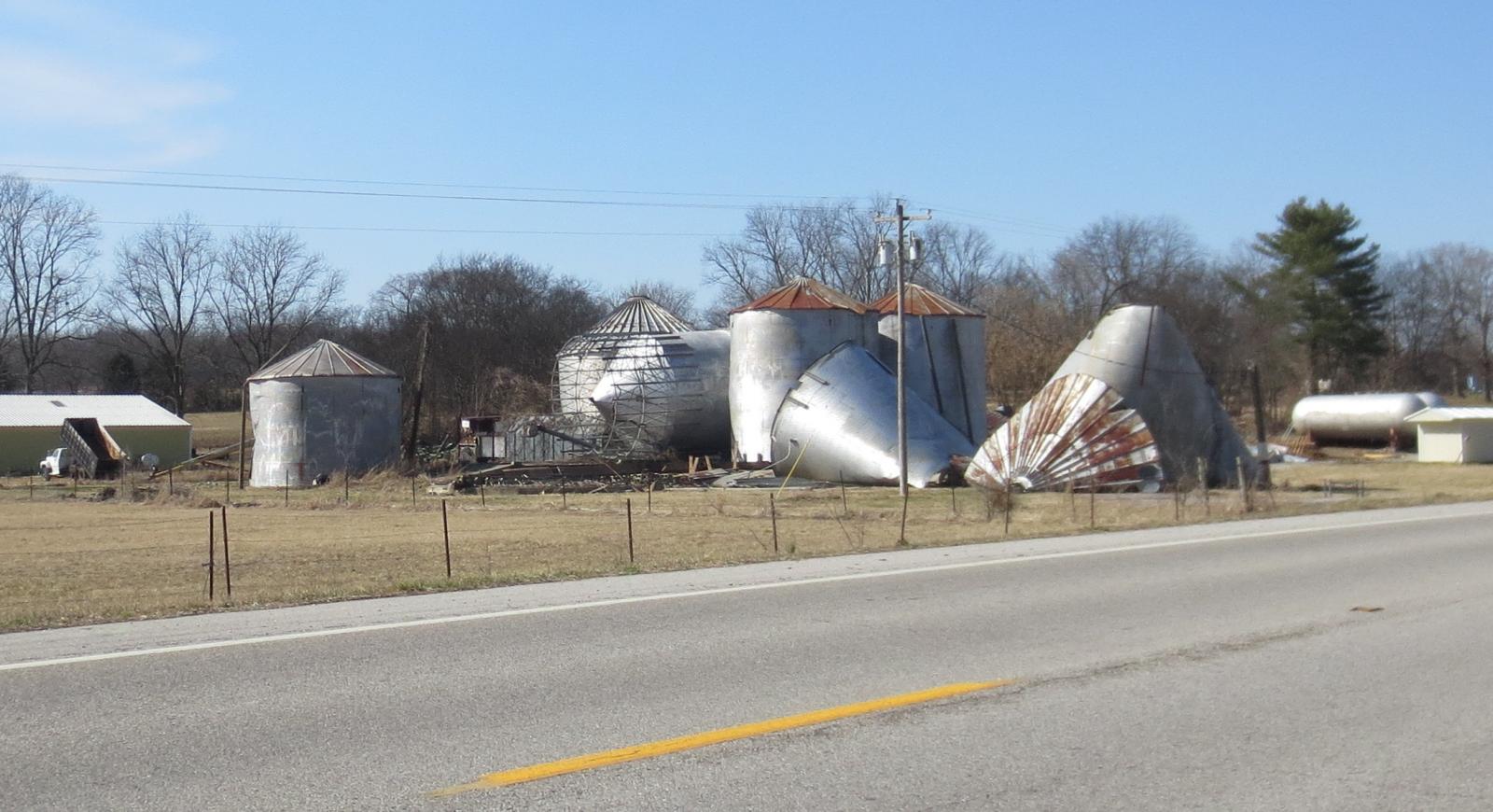
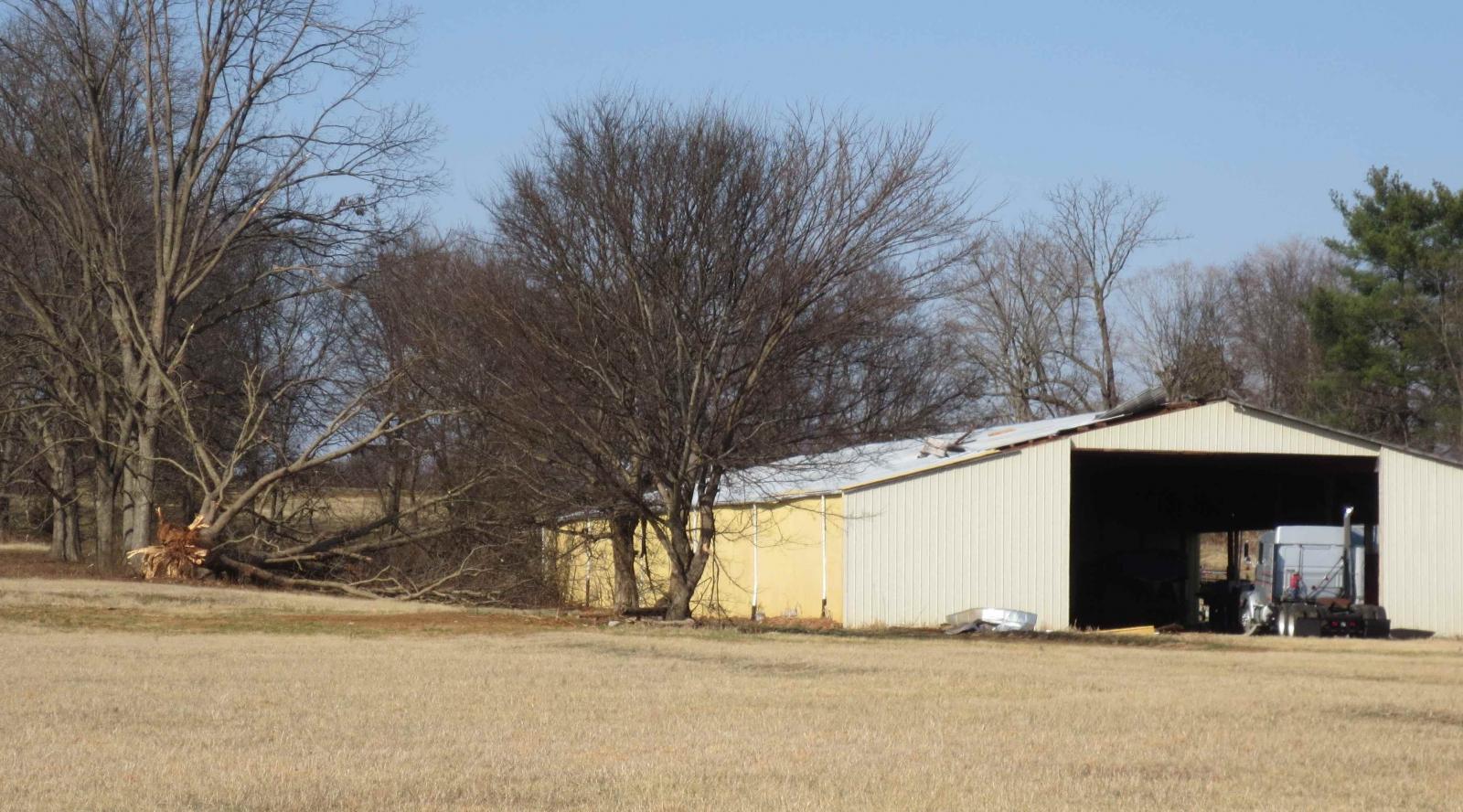
Based on social media reports from the public, a NWS storm survey was conducted in extreme southeast Coffee County to investigate damage from severe thunderstorms on Thursday evening, February 20 2014. One EF1 tornado was confirmed to have touched down along Interstate 24 northwest of Pelham, where a tree was snapped and two billboards damaged along I-24. Several more trees were uprooted along Betsy Willis Road. A farm suffered significant damage just north of Betsy Willis Road on the west side of Highway 41, with 3 grain silos were blown off their base and destroyed, and a barn losing part of its roof. An outbuilding at the farm was destroyed with debris blown southeast across Highway 41. Another barn on the east side of Highway 41 suffered minor roof damage. More trees were blown down east of Highway 41 with another outbuilding destroyed and debris blown across adjacent fields. The tornado then moved into inaccessible forested areas before lifting. |
|
|
Radar:
|
|
|
NWS Storm Survey photos:
|
|
| Robertson County Downburst | |
| Counties: | Robertson |
| Time: | 700-730 PM |
| Wind Speed Estimate: | 60-80 MPH |
| Damage Path Length: | 20 Miles |
| Damage Path Width: | 5 miles |
|
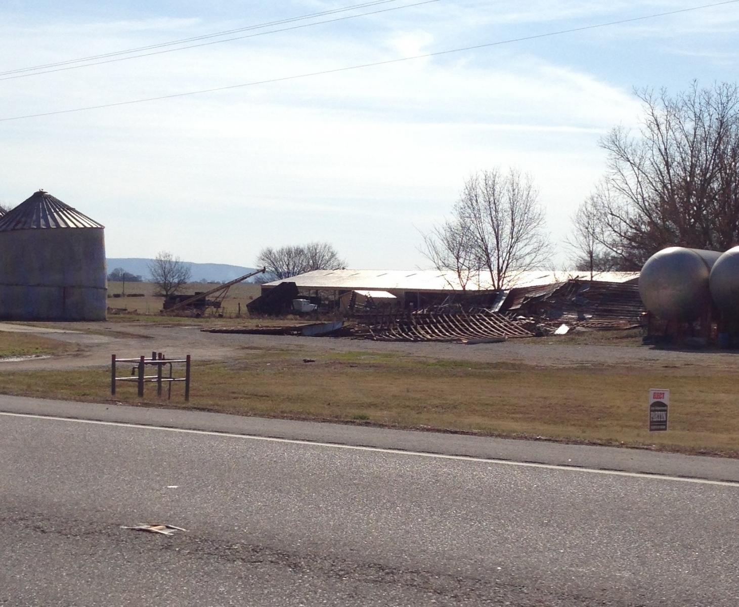
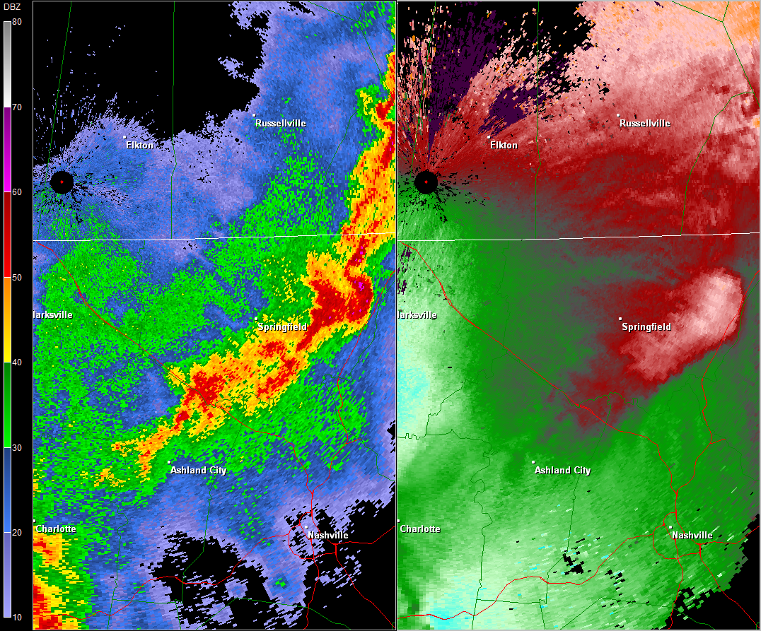
A National Weather Service storm survey team concluded that a large downburst struck much of southern and eastern Robertson County (see radar image below), with some of the worst damage in the Cross Plains community. In Cross Plains, damage consisted of a few trees with large limbs that were snapped and large outbuildings with roof damage. One such large outbuilding, which stored large farming equipment, completely lost its aluminum roofing in the winds. The maximum wind speed was estimated to be 77 mph based off the level of damage to the outbuilding. The wind damage was located along Highway 25 spanning from about 4 miles west of Cross Plains, to the community of Cross Plains. Elsewhere across southern and eastern Robertson County, a home had minor roof and siding damage on Highway 257 southwest of Springfield, and an old barn was destroyed and partially blown onto Pinson School Road east of Springfield (photo 1 below). An old abandoned mobile home was blown off its blocks and destroyed on Bob Carr Road west of Cross Plains (photo 2 below), and a power pole was snapped off and landed on a car along Highway 25 east of Orlinda (photo 3 below) briefly trapping the occupants. Numerous trees and power lines were blown down all along the path, resulting in widespread power outages (photo 4 below). |
|
|
Radar:
|
|


 Follow us on YouTube