February 6-7, 2019 Flash Flooding & Tornadoes
|
Heavy rain and thunderstorms produced tornadoes and widespread flash flooding across Middle Tennessee, starting on the afternoon of February 6 and continuing through the early morning on February 7. A warm front that had moved northward into Kentucky early in the day sank back southward to near the Interstate 40 corridor by the afternoon hours on Wednesday (2/6), sparking numerous showers and thunderstorms along and just north of the front. As the front effectively stalled in a west-to-east line along the Interstate 40 corridor, showers and storms continued to redevelop and move across the same areas. With rainfall rates approaching 1-2" per hour at times, this led to widespread flash flooding across Humphreys, Dickson, Cheatham, Davidson, Wilson, Smith, Jackson, Putnam, and Overton Counties. This flooding resulted in numerous closed roadways, dozens of water rescues, significant rises on area creeks and rivers, and unfortunately one fatality in Cheatham County. Total rainfall amounts ranged from 3 inches to nearly 7 inches across these counties. In addition to the flooding, thunderstorms produced three EF-0 tornadoes in Dickson/Williamson, Rutherford and Wilson Counties. Lightning also struck homes in Overton and Jackson counties, causing significant fire damage. |
 |
Tornadoes:
|
Tornado #1 - Milton, TN
Track Map 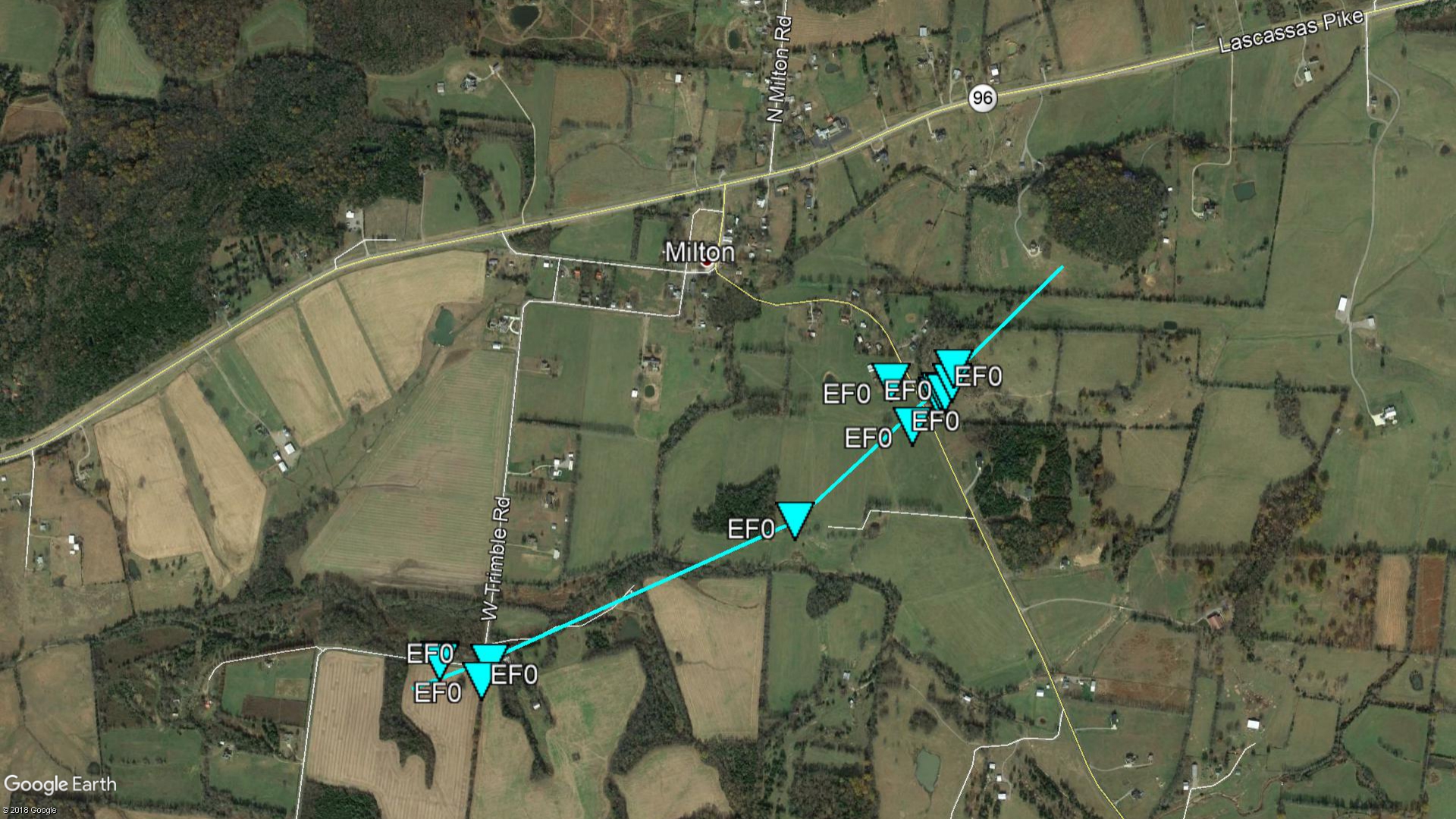 
|
||||||||||||||||
|
Tornado #2 - Burns, TN
Track Map 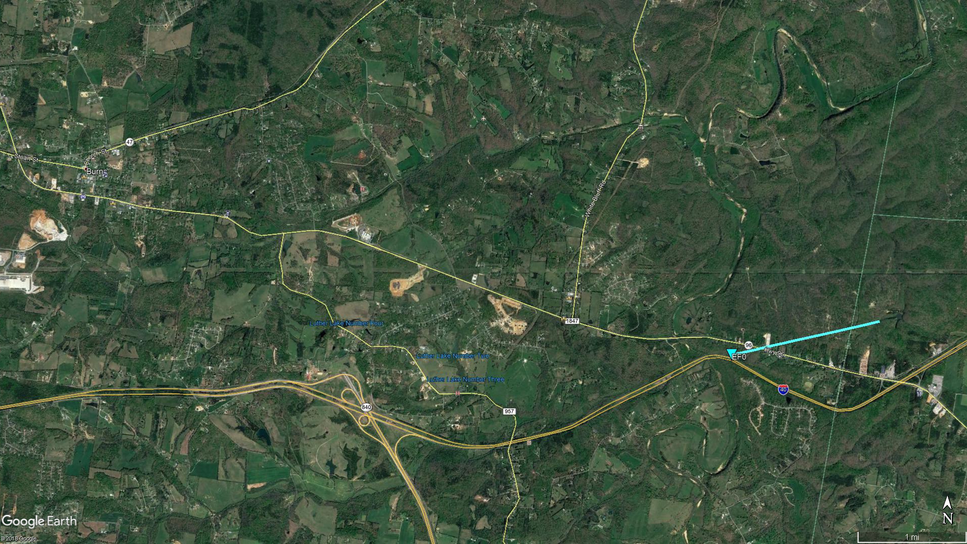
|
||||||||||||||||
|
Tornado #2 - Tuckers Crossroads, TN
Track Map 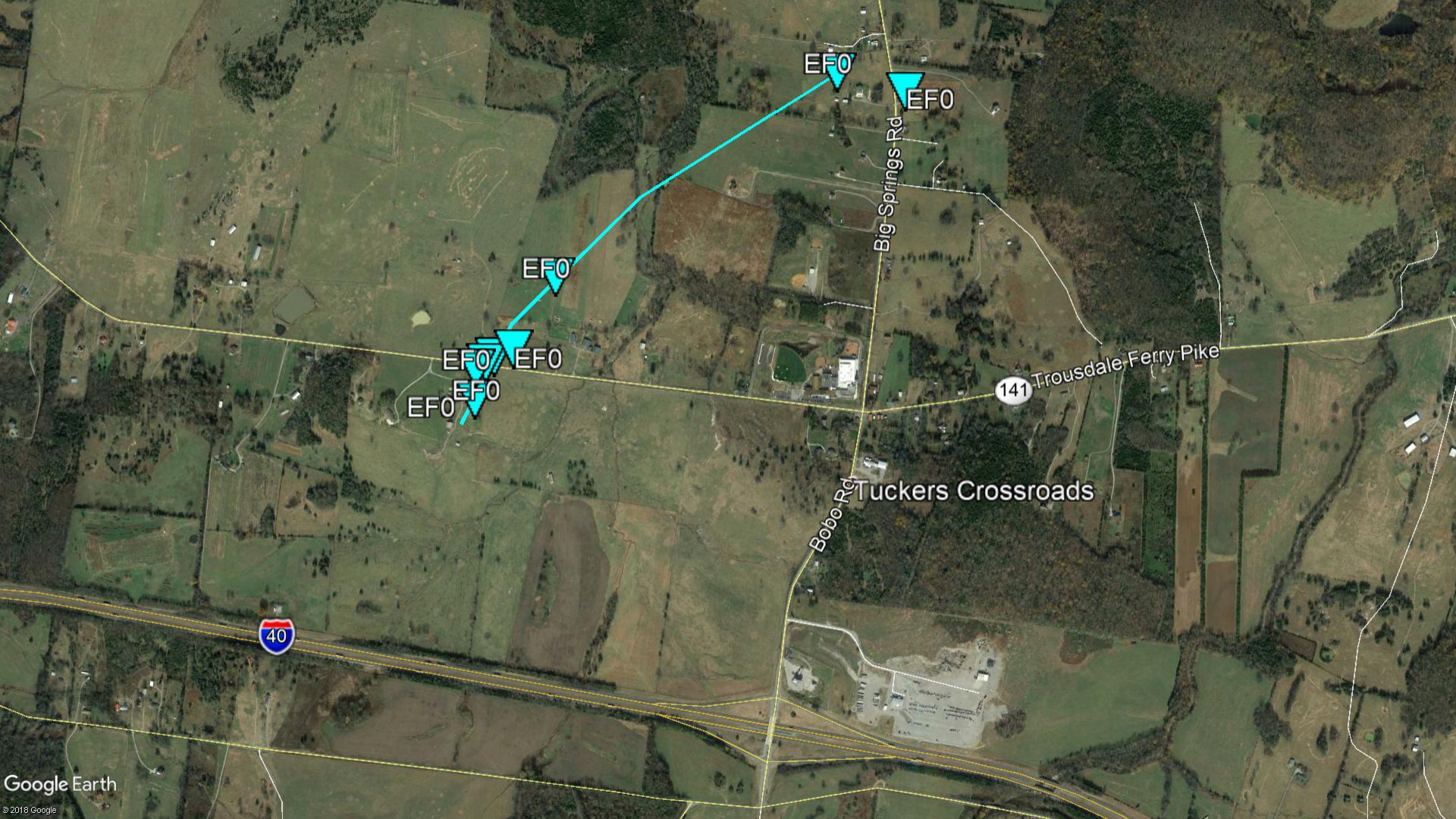
|
||||||||||||||||
The Enhanced Fujita (EF) Scale classifies tornadoes into the following categories:
| EF0 Weak 65-85 mph |
EF1 Moderate 86-110 mph |
EF2 Significant 111-135 mph |
EF3 Severe 136-165 mph |
EF4 Extreme 166-200 mph |
EF5 Catastrophic 200+ mph |
 |
|||||
Wind:
Public Information Statement
National Weather Service Nashville TN
415 PM CST Thu Feb 7 2019
...PEAK WIND GUSTS ON FEBRUARY 7 2019 AS OF 415 PM CST...
Location Speed Time/Date Provider
7 ENE Centerville 47 MPH 0402 PM 02/07 CWOP
Nashville Intl Airport 45 MPH 1111 AM 02/07 ASOS
Outlaw Field Airport 43 MPH 1221 PM 02/07 ASOS
1 SW Centerville 43 MPH 1222 PM 02/07 CWOP
3 SE Franklin 41 MPH 1153 AM 02/07 CWOP
2 SSW Nashville 41 MPH 1159 AM 02/07 CWOP
2 NNE Murfreesboro 41 MPH 1155 AM 02/07 AWOS
Shelbyville 40 MPH 0115 PM 02/07 AWOS
2 NNE Brentwood 39 MPH 1146 AM 02/07 CWOP
4 N Lewisburg 37 MPH 1155 AM 02/07 AWOS
Columbia/mount Pleasant 37 MPH 0255 PM 02/07 AWOS
Mcminnville 37 MPH 1115 AM 02/07 AWOS
Sparta 37 MPH 1255 PM 02/07 AWOS
4 WSW Belle Meade 36 MPH 1000 PM 02/06 CWOP
Crossville Memorial Airport 36 MPH 1028 AM 02/07 ASOS
2 NNE Spring Hill 36 MPH 0101 PM 02/07 CWOP
Nashville John C Tune Arpt 36 MPH 1035 AM 02/07 AWOS
3 SSW Pulaski 36 MPH 1135 AM 02/07 RAWS
3 NNW Rockwood 36 MPH 0155 PM 02/07 AWOS
Springfield 36 MPH 0315 PM 02/07 AWOS
3 N Smyrna 36 MPH 1125 AM 02/07 AWOS
5 SSE Gallatin 35 MPH 0130 PM 02/07 CWOP
Lawrenceburg 34 MPH 0115 PM 02/07 CWOP
2 N Spring Hill 33 MPH 1100 AM 02/07 CWOP
Woodbury 33 MPH 1216 PM 02/07 CWOP
2 WNW Monteagle 33 MPH 0327 PM 02/07 CWOP
8 WNW Lewisburg 33 MPH 0130 PM 02/07 CWOP
2 NNE Watertown 32 MPH 1231 PM 02/07 CWOP
Tullahoma 32 MPH 1215 PM 02/07 AWOS
Observations are collected from a variety of sources with varying
equipment and exposures. We thank all volunteer weather observers
for their dedication. Not all data listed are considered official.
$$
Shamburger
Photos:
Tornado Damage
.jpg) |
.jpg) |
.jpg) |
.jpg) |
| Wilson County near Tuckers Crossroads, TN (NWS storm survey photo) |
Wilson County near Tuckers Crossroads, TN (NWS storm survey photo) |
Rutherford County near Milton, TN (NWS storm survey photo) |
Rutherford County near Milton, TN (NWS storm survey photo) |
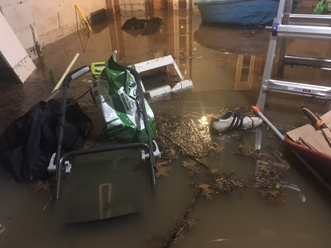
Flooding
 |
 |
 |
 |
| 1800 Block of Nolensville Rd (via Facebook) |
Trinity and Ellington Pkwy (via Twitter) |
Church St and George L Davis Blvd (via Twitter) |
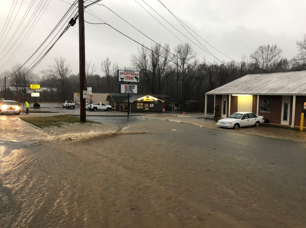
Flash flooding in Dickson, TN (via Twitter) |
 |
 |
.PNG) |
 |
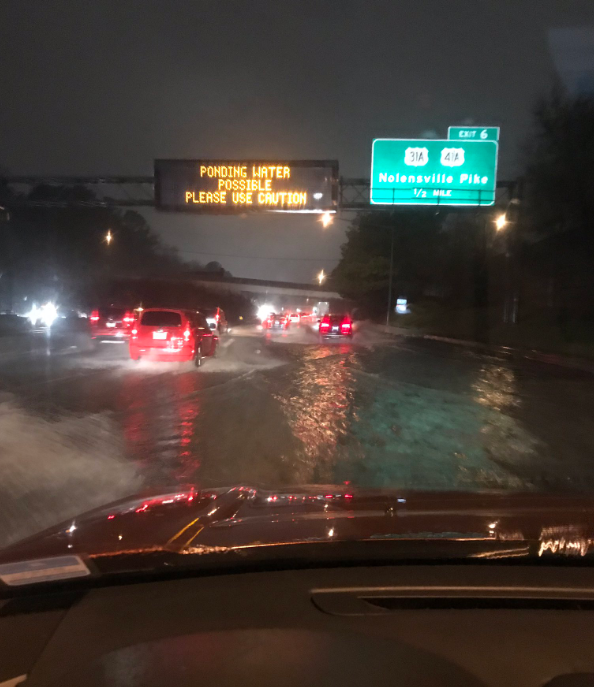
| Flooding on I-440 at Nolensville Pike (via Twitter) |
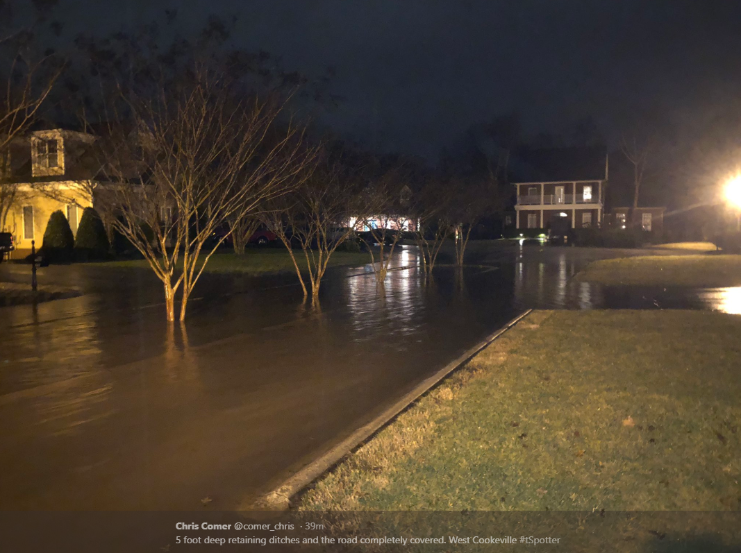
Flooding in Cookeville, TN (via Twitter) |
Central Pike and Chandler Rd (via Twitter) |
Rosa Parks Blvd @ Farmer's Market (via Twitter) |
Radar:
 |
|||
| OHX Radar Loop from February 6-7, 2019 |
Storm Reports
PRELIMINARY LOCAL STORM REPORT...SUMMARY
NATIONAL WEATHER SERVICE NASHVILLE TN
847 AM CST SUN FEB 10 2019
..TIME... ...EVENT... ...CITY LOCATION... ...LAT.LON...
..DATE... ....MAG.... ..COUNTY LOCATION..ST.. ...SOURCE....
..REMARKS..
0235 PM TORNADO 6 WSW AUBURNTOWN 35.92N 86.19W
02/06/2019 RUTHERFORD TN NWS STORM SURVEY
AN EF-0 TORNADO TOUCHED DOWN ALONG WEST TRIMBLE RD JUST
SOUTH OF MILTON AND MOVED NORTHEAST ACROSS HALLS HILL
PIKE BEFORE LIFTING SOUTH OF HWY 96. ONE LARGE BARN WEST
OF HALLS HILL PIKE WAS DESTROYED WITH DEBRIS BLOWN UP TO
500 YARDS AWAY. TWO HOMES RECEIVED MINOR ROOF DAMAGE. AN
OUTBUILDING LOST PART OF ITS ROOF AND A CARPORT WAS
DESTROYED. DOZENS OF TREES WERE SNAPPED AND UPROOTED
ALONG THE PATH. PATH LENGTH 1.2 MI AND PATH WIDTH 75
YDS.
0236 PM TSTM WND DMG 5 WSW AUBURNTOWN 35.93N 86.18W
02/06/2019 RUTHERFORD TN FIRE DEPT/RESCUE
CARPORT ON FRONT OF HOME DESTROYED. ROOF DAMAGE TO
DOUBLE-WIDE HOME. SCATTERED TREE DAMAGE/MINOR DEBRIS
NEAR W TRIMBLE RD AND HALLS HILL PIKE.
0510 PM FLASH FLOOD 2 SSE WEST NASHVILLE 36.13N 86.84W
02/06/2019 DAVIDSON TN SOCIAL MEDIA
CREEK OVERFLOWING ITS BANKS AND FIELDS FLOODED AT
MONTGOMERY BELL ACADEMY.
0521 PM FLASH FLOOD 1 SSW NASHVILLE 36.16N 86.79W
02/06/2019 DAVIDSON TN SOCIAL MEDIA
VIDEO OF FLASH FLOODING AT EXXON ON CHARLOTTE AND I-40.
0542 PM FLASH FLOOD MOUNT JULIET 36.21N 86.52W
02/06/2019 WILSON TN EMERGENCY MNGR
CENTRAL PIKE AND CHANDLER ROAD CLOSED DUE TO FLASH
FLOODING.
0550 PM FLASH FLOOD LEBANON 36.21N 86.32W
02/06/2019 WILSON TN EMERGENCY MNGR
2200 BLOCK OF CAIRO BEND ROAD IS CLOSED DUE TO FLASH
FLOODING.
0552 PM FLASH FLOOD MOUNT JULIET 36.21N 86.52W
02/06/2019 WILSON TN EMERGENCY MNGR
2800 BLOCK OF QUARRY ROAD MULTIPLE VEHICLES STALLED DUE
TO FLASH FLOODING.
0600 PM FLASH FLOOD LEBANON 36.21N 86.32W
02/06/2019 WILSON TN EMERGENCY MNGR
3000 BLOCK FO OLD ROME PK CLOSED DUE TO FLASH FLOODING.
0602 PM FLASH FLOOD MOUNT JULIET 36.21N 86.52W
02/06/2019 WILSON TN EMERGENCY MNGR
MAYS CHAPEL ROAD AND BENDERS FERRY ROAD NEAR HTE BRIDGE
CLOSED DUE TO FLASH FLOODING.
0612 PM FLASH FLOOD 2 E MOUNT JULIET 36.21N 86.49W
02/06/2019 WILSON TN LAW ENFORCEMENT
LAW ENFORCEMENT REPORTS CAR SUBMERGED ON PLOWSON ROAD.
ALL OCCUPANTS WERE ABLE TO EXIT VEHICLE.
0619 PM FLASH FLOOD LEBANON 36.21N 86.32W
02/06/2019 WILSON TN EMERGENCY MNGR
OLD ROME PK AND GOSHEN ROAD CLOSED DUE TO FLASH
FLOODING.
0625 PM FLASH FLOOD 1 SSE DICKSON 36.06N 87.37W
02/06/2019 DICKSON TN SOCIAL MEDIA
FACEBOOK PHOTOS SHOWED SIGNIFICANT FLASH FLOODING AT
BARBEQUE ROAD AND HIGHWAY 46 AROUND THE DICKSON
SPORTSMAN STORE WITH BARBEQUE ROAD CLOSED.
0627 PM FLASH FLOOD MOUNT JULIET 36.21N 86.52W
02/06/2019 WILSON TN EMERGENCY MNGR
1538 MAYS CHAPEL ROAD CAR STALLED DUE TO FLASH
FLOODING.
0630 PM FLASH FLOOD LEBANON 36.21N 86.32W
02/06/2019 WILSON TN EMERGENCY MNGR
1000 BLOCK OF OLD ROME PK CLSED DUE TO FLASH FLOODING.
0630 PM FLASH FLOOD LEBANON 36.21N 86.32W
02/06/2019 WILSON TN EMERGENCY MNGR
CROWELL LANE BETWEEN LEEVILLE AND TUCKERS GAP ROAD
CLOSED DUE TO FLASH FLOODING. TIME IS ESTIMATED.
0636 PM FLASH FLOOD MOUNT JULIET 36.21N 86.52W
02/06/2019 WILSON TN EMERGENCY MNGR
CENTRAL PIKE AND EARNHART ROAD CLOSED DUE TO FLASH
FLOODING.
0641 PM FLASH FLOOD LEBANON 36.21N 86.32W
02/06/2019 WILSON TN EMERGENCY MNGR
791 E. OLD LAGUARDO ROAD CLOSED DUE TO FLASH FLOODING.
0655 PM FLASH FLOOD MOUNT JULIET 36.21N 86.52W
02/06/2019 WILSON TN EMERGENCY MNGR
7294 HICKORY RIDGE ROAD CLOSED DUE TO FLASH FLOODING.
0658 PM FLASH FLOOD MOUNT JULIET 36.21N 86.52W
02/06/2019 WILSON TN EMERGENCY MNGR
2253 BECKWITH ROAD, 4-5 FEET OF WATER RUNNING OVER THE
ROAD. ROAD CLOSED DUE TO FLASH FLOODING.
0700 PM LIGHTNING 8 WSW LIVINGSTON 36.36N 85.47W
02/06/2019 OVERTON TN EMERGENCY MNGR
LIGHTNING DAMAGE TO A HOUSE ON SWAN LANE.
0700 PM TSTM WND DMG 4 W MONTEREY 36.13N 85.32W
02/06/2019 PUTNAM TN EMERGENCY MNGR
TREE DOWN ON MONTEREY HWY.
0702 PM FLASH FLOOD LEBANON 36.21N 86.32W
02/06/2019 WILSON TN EMERGENCY MNGR
PARK AVENUE AND HARDING DRIVE CLOSED DUE TO FLASH
FLOODING.
0711 PM FLASH FLOOD LEBANON 36.21N 86.32W
02/06/2019 WILSON TN EMERGENCY MNGR
3187 CEDAR GROVE ROAD CLOSED DUE TO FLASH FLOODING.
0718 PM FLASH FLOOD LEBANON 36.21N 86.32W
02/06/2019 WILSON TN EMERGENCY MNGR
3945 OLD ROME PK VEHICLE STALLED DUE TO FLASH FLOODING.
0735 PM FLASH FLOOD LEBANON 36.21N 86.32W
02/06/2019 WILSON TN EMERGENCY MNGR
MARTHA LEEVILLE ROAD AND EASTGATE BLVD VEHICLE STUCK
DUE TO FLASH FLOODING.
0752 PM LIGHTNING 9 W GAINESBORO 36.35N 85.81W
02/06/2019 JACKSON TN 911 CALL CENTER
REPORT FROM 911 CENTER AND FACEBOOK OF LIGHTNING
STRIKING A HOUSE AND STARTING A FIRE IN THE GLADDICE
COMMUNITY...GLADDICE HWY AND SMITHS BEND RD.
0759 PM FLASH FLOOD 2 ENE COOKEVILLE 36.17N 85.48W
02/06/2019 PUTNAM TN EMERGENCY MNGR
WATER FLOWING OVER ROADWAY, IMPASSABLE. FISK RD AT E
BROAD ST.
0808 PM FLASH FLOOD LEBANON 36.21N 86.32W
02/06/2019 WILSON TN EMERGENCY MNGR
2100 BLOCK FO BEASLEY BEND ROAD CLOSED DUE TO FLASH
FLOODING.
0817 PM FLASH FLOOD LEBANON 36.21N 86.32W
02/06/2019 WILSON TN EMERGENCY MNGR
4200 BLOCK OF LEBANON ROAD, WATER IS APPRAOCHING A
HOME.
0845 PM FLASH FLOOD COOKEVILLE 36.16N 85.51W
02/06/2019 PUTNAM TN EMERGENCY MNGR
PUTNAM COUNTY EMERGENCY MANAGEMENT REPORTED NUMEROUS
STREETS FLOODED ACROSS COOKEVILLE WITH SEVERAL VEHICLES
STRANDED AND WATER RESCUES CONDUCTED. ROADS THAT WERE
FLOODED INCLUDED SOUTH WALNUT ST BETWEEN BORDEN ST AND
JACKSON ST.
0849 PM FLASH FLOOD WOODBINE 36.12N 86.75W
02/06/2019 DAVIDSON TN TRAINED SPOTTER
WESTBOUND I-440 BEFORE NOLENSVILLE PIKE EXIT, RIGHT TWO
LANES FLOODED.
0906 PM FLASH FLOOD LEBANON 36.21N 86.32W
02/06/2019 WILSON TN EMERGENCY MNGR
JOHNSON ROAD HARTSVILLE PK RAOD CLOSED DUE TO FLASH
FLOODING.
0930 PM FLASH FLOOD WAVERLY 36.09N 87.79W
02/06/2019 HUMPHREYS TN EMERGENCY MNGR
HIGH WATER ALONG HWY 70 AND ON SR-13 SOUTH. DEBRIS
BEING REMOVED FROM ROADWAY.
0949 PM TORNADO 1 W TUCKERS CROSSROADS 36.20N 86.19W
02/06/2019 WILSON TN NWS STORM SURVEY
A BRIEF, WEAK EF-0 TORNADO TOUCHED DOWN ALONG TROUSDALE
FERRY PIKE JUST WEST OF TUCKERS CROSSROADS AND CURVED
NORTHEAST BEFORE LIFTING NEAR BIG SPRINGS ROAD. ONE BARN
AT THE BEGINNING OF THE PATH WAS DESTROYED WITH DEBRIS
BLOWN UP TO 1/2 MILE AWAY. ONE HOME AND SOME TREES
ACROSS THE STREET RECEIVED MINOR DAMAGE. A FEW MORE
TREES WERE BLOWN DOWN IN FIELDS WEST OF BIG SPRINGS ROAD
BEFORE THE TORNADO LIFTED. PATH LENGTH 0.97 MI AND PATH
WIDTH 50 YDS.
0955 PM FLASH FLOOD PEGRAM 36.10N 87.06W
02/06/2019 CHEATHAM TN EMERGENCY MNGR
*** 1 FATAL *** A WOMAN WAS SWEPT OFF A BRIDGE WHILE
TRYING TO CROSS ON FOOT. OCCURRED AT 4660 PONDS CREEK
RD.
0957 PM FLASH FLOOD 2 N BELLE MEADE 36.12N 86.85W
02/06/2019 DAVIDSON TN SOCIAL MEDIA
FLASH FLOODING NEAR THE KROGER IN BELLE MEADE ON
HARDING PIKE.
0959 PM FLASH FLOOD 1 ESE DICKSON 36.07N 87.36W
02/06/2019 DICKSON TN SOCIAL MEDIA
PHOTO AND REPORT OF A FOOT OF WATER OR MORE ON SHADY
HOLLOW RD FROM COLLEGE ST TO LUTHER RD.
1000 PM FLASH FLOOD 2 NNE GREEN HILLS 36.13N 86.81W
02/06/2019 DAVIDSON TN BROADCAST MEDIA
ST. BERNARD ACADEMY FLOODED WITH FOUR INCHES OF WATER.
SEVERAL STREETS AROUND HILLSBORO VILLAGE AND NEAR THE
VANDERBILT CAMPUS FLOODED.
1002 PM FLASH FLOOD PEGRAM 36.10N 87.06W
02/06/2019 CHEATHAM TN EMERGENCY MNGR
WATER RESCUE AT GREEN VALLEY DR. AND PONDS CREEK RD. A
MAN ATTEMPTED TO CROSS HIGH WATER AND WAS RESCUED FROM
THE HOOD OF HIS CAR.
1012 PM FLASH FLOOD 1 WSW DICKSON 36.07N 87.40W
02/06/2019 DICKSON TN TRAINED SPOTTER
REPORTS OF FLOODING ACROSS THE COUNTY WITH A FOOT OF
WATER OVER SOME ROADWAYS.
1030 PM HEAVY RAIN INGLEWOOD 36.21N 86.73W
02/06/2019 M5.75 INCH DAVIDSON TN NWS EMPLOYEE
NWS EMPLOYEE REPORTS HEAVY RAIN STILL FALLING.
1031 PM HEAVY RAIN WEST NASHVILLE 36.16N 86.85W
02/06/2019 M5.94 INCH DAVIDSON TN MEDIA
AS OF 10:30 PM. STILL RAINING.
1100 PM FLASH FLOOD 5 SW DICKSON 36.03N 87.44W
02/06/2019 DICKSON TN EMERGENCY MNGR
A BRIDGE ON COON CREEK RD WAS WASHED OUT. SECTIONS OF
SEVERAL OTHER ROADS WERE WASHED OUT AS WELL. MULTIPLE
ROADS ARE STILL CLOSED.
1100 PM FLASH FLOOD GAINESBORO 36.36N 85.65W
02/06/2019 JACKSON TN SOCIAL MEDIA
FACEBOOK VIDEO SHOWED FLOODING IN AND AROUND GAINESBORO
ELEMENTARY SCHOOL
1100 PM FLASH FLOOD 4 SSE CHARLOTTE 36.13N 87.31W
02/06/2019 DICKSON TN SOCIAL MEDIA
A BRIDGE ON WILLOW BRANCH ROAD AT LIBERTY ROAD WAS
WASHED AWAY
1100 PM FLASH FLOOD 9 SSW RED BOILING SPRIN 36.41N 85.93W
02/06/2019 SMITH TN SOCIAL MEDIA
TSPOTTER REPORT OF HIGHWAY 70 BETWEEN HIWASSEE ROAD AND
THE DOLLAR GENERAL IN THE ROME COMMUNITY BEING FLOODED.
ANOTHER REPORT OF FLOODING COVERING PLEASANT SHADE
HIGHWAY JUST SOUTH OF THE MACON COUNTY LINE.
1111 PM FLASH FLOOD 1 NNE BERRY HILL 36.13N 86.76W
02/06/2019 DAVIDSON TN EMERGENCY MNGR
NASHVILLE OEM AND LOCAL MEDIA REPORTED MAJOR FLASH
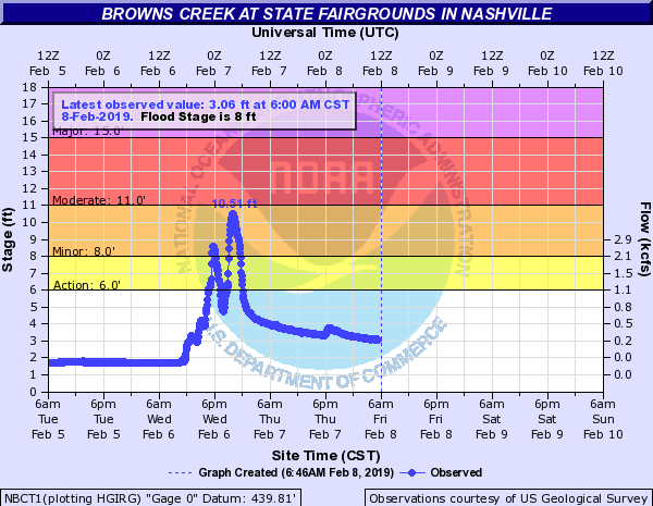
FLOODING AROUND THE FAIRGROUNDS IN SOUTH NASHVILLE NEAR
BROWNS CREEK. SEVERAL VEHICLES WERE STRANDED AT
NOLENSVILLE ROAD AND WALSH ROAD WITH WATER RESCUES
ONGOING. BUSINESSES WERE FLOODED ALONG NOLENSVILLE ROAD
AND AN APARTMENT BUILDING WAS FLOODED ON LEWIS STREET.
1122 PM FLASH FLOOD 2 ESE INGLEWOOD 36.20N 86.71W
02/06/2019 DAVIDSON TN SOCIAL MEDIA
VIDEO OF FLOOD WATER COMING UP INTO HOUSE THROUGH
BATHROOM PLUMBING FIXTURE.
1125 PM FLASH FLOOD 1 NE BELLE MEADE 36.12N 86.84W
02/06/2019 DAVIDSON TN SOCIAL MEDIA
4 TO 5 INCHES ON ROAD AT DARTMOUTH AND WOODMONT LN IN
GREEN HILLS.
1130 PM FLASH FLOOD 4 SE TENNESSEE CITY 36.06N 87.46W
02/06/2019 DICKSON TN BROADCAST MEDIA
SEVERAL VEHICLES WERE STRANDED IN FLOODING ON ENO ROAD
AND ON HARRIS ROAD WITH WATER RESCUES CONDUCTED
1148 PM FLASH FLOOD 1 WSW INGLEWOOD 36.20N 86.75W
02/06/2019 DAVIDSON TN SOCIAL MEDIA
EAST NASHVILLE NEAR TRINITY LN AND ELLINGTON PKWY.
PHOTOS OF BASEMENT PORTION OF HOME FLOODED.
1209 AM FLASH FLOOD MOUNT JULIET 36.21N 86.52W
02/07/2019 WILSON TN EMERGENCY MNGR
A LIST OF ROADS CLOSED DUE TO FLASH FLOODING. WOODRIDGE
PLACE NEAR GOLDEN BEAR GATEWAY. W. DIVISION STREET NEAR
MT. JULIET ELEMENTARY. OLD LEBANON DIRT ROAD NEAR PAGE
DRIVE. CEDAR DRIVE BEHIND VALLEY CENTER. YOR ROAD NEAR
LEBANON ROAD.
0215 AM FLASH FLOOD LEBANON 36.21N 86.32W
02/07/2019 WILSON TN EMERGENCY MNGR
WATER IS MOVING INTO DOWNTOWN LEBANON (US 231 AND W.
SPRING STREET). WATER HAS GOTTEN INTO SOME OF THE
BUILDINGS.
0230 AM FLASH FLOOD LEBANON 36.21N 86.32W
02/07/2019 WILSON TN EMERGENCY MNGR
SWIFT WATER RESCUE ON US 231 DUE TO FLASH FLOODING.
0420 AM HEAVY RAIN 1 S MOUNT JULIET 36.19N 86.52W
02/07/2019 M5.86 INCH WILSON TN NWS EMPLOYEE
5.86 INCHES OF RAIN REPORTED IN MT. JULIET JUST WEST OF
MT. JULIET ROAD.
0505 AM FLASH FLOOD MOUNT JULIET 36.21N 86.52W
02/07/2019 WILSON TN LAW ENFORCEMENT
THE FOLLOWING ROADS ARE STILL CLOSED IN MT. JULIET DUE
TO FLASH FLOODING. WODDRIDGE PLACE NEAR GODLEN BEAR
GATEWAY. W. DIVISION STREET NEAR MT. JULIET ELEMENTARY.
OLD LEBANON DIRT ROAD NEAR PAGE DRIVE. YORK ROAD NEAR
LEBAONON ROAD.
0600 AM HEAVY RAIN 1 NE LANGFORD COVE 36.25N 86.56W
02/07/2019 M3.93 INCH WILSON TN OFFICIAL NWS OBS
24 HOUR RAIN TOTAL FROM NWS NASHVILLE OFFICE
0600 AM HEAVY RAIN GAINESBORO 36.36N 85.65W
02/07/2019 M3.95 INCH JACKSON TN CO-OP OBSERVER
24 HOUR RAIN TOTAL
0600 AM HEAVY RAIN CARTHAGE 36.26N 85.94W
02/07/2019 M3.80 INCH SMITH TN CO-OP OBSERVER
24 HOUR RAIN TOTAL
0600 AM HEAVY RAIN 4 S NEW JOHNSONVILLE 35.96N 87.96W
02/07/2019 M5.20 INCH HUMPHREYS TN CO-OP OBSERVER
24 HOUR RAIN TOTAL
0605 AM FLASH FLOOD LEBANON 36.21N 86.32W
02/07/2019 WILSON TN PUBLIC
DUE TO FLASH FLOODING THE MUSIC CITY STAR TRAIN HAS
CANCELLED CUMMUTER RAIL SERVICE THIS MORNING DUE TO
IMPASSIBLE TRACKS IN WILSON COUNTY.
0647 AM HEAVY RAIN NASHVILLE 36.17N 86.78W
02/07/2019 M6.12 INCH DAVIDSON TN PUBLIC
IN THE OPRYLAND/MCGAVOCK PIKE ARE 6.12 INCHES OF RAIN
FELL.
0700 AM HEAVY RAIN HERMITAGE 36.20N 86.62W
02/07/2019 E5.00 INCH DAVIDSON TN SOCIAL MEDIA
IN EXCESS OF FIVE INCHES OF TOTAL RAINFALL WAS REPORTED
IN HERMITAGE OVER THE PAST 24 HOURS.
0800 AM HEAVY RAIN EAST NASHVILLE 36.17N 86.76W
02/07/2019 M6.10 INCH DAVIDSON TN NWS EMPLOYEE
24 HOUR RAIN TOTAL
0855 AM HEAVY RAIN KINGSTON SPRINGS 36.10N 87.10W
02/07/2019 M6.19 INCH CHEATHAM TN COCORAHS
24 HOUR RAIN TOTAL
0855 AM HEAVY RAIN 6 W DICKSON 36.08N 87.48W
02/07/2019 M5.89 INCH DICKSON TN COCORAHS
24 HOUR RAIN TOTAL
0855 AM HEAVY RAIN 1 NNE WHITE BLUFF 36.12N 87.21W
02/07/2019 M6.12 INCH DICKSON TN COCORAHS
24 HOUR RAIN TOTAL
0855 AM HEAVY RAIN 2 WNW BELLE MEADE 36.11N 86.89W
02/07/2019 M5.48 INCH DAVIDSON TN COCORAHS
24 HOUR RAIN TOTAL
0855 AM HEAVY RAIN 4 WSW NASHVILLE 36.15N 86.85W
02/07/2019 M5.94 INCH DAVIDSON TN COCORAHS
24 HOUR RAIN TOTAL
0855 AM HEAVY RAIN 11 E LEBANON 36.21N 86.13W
02/07/2019 M5.11 INCH WILSON TN COCORAHS
24 HOUR RAIN TOTAL
0855 AM HEAVY RAIN 1 SW KINGSTON SPRINGS 36.08N 87.12W
02/07/2019 M5.20 INCH CHEATHAM TN COCORAHS
24 HOUR RAIN TOTAL
0855 AM HEAVY RAIN GREEN HILL 36.23N 86.57W
02/07/2019 M5.33 INCH WILSON TN COCORAHS
24 HOUR RAIN TOTAL
0855 AM HEAVY RAIN 3 WSW MOUNT JULIET 36.19N 86.57W
02/07/2019 M5.68 INCH DAVIDSON TN COCORAHS
24 HOUR RAIN TOTAL
0855 AM HEAVY RAIN 1 ESE BELLE MEADE 36.09N 86.84W
02/07/2019 M6.20 INCH DAVIDSON TN COCORAHS
24 HOUR RAIN TOTAL
0855 AM HEAVY RAIN 6 NE CLARKRANGE 36.24N 84.94W
02/07/2019 M4.70 INCH FENTRESS TN COCORAHS
24 HOUR RAIN TOTAL
0855 AM HEAVY RAIN 2 NNW LIVINGSTON 36.42N 85.34W
02/07/2019 M3.44 INCH OVERTON TN COCORAHS
24 HOUR RAIN TOTAL
0855 AM HEAVY RAIN 1 SW COOKEVILLE 36.15N 85.52W
02/07/2019 M3.76 INCH PUTNAM TN COCORAHS
24 HOUR RAIN TOTAL
0855 AM HEAVY RAIN 3 WSW CARTHAGE 36.24N 85.99W
02/07/2019 M4.47 INCH SMITH TN COCORAHS
24 HOUR RAIN TOTAL
0855 AM HEAVY RAIN 5 WSW NASHVILLE 36.14N 86.87W
02/07/2019 M6.62 INCH DAVIDSON TN COCORAHS
24 HOUR RAIN TOTAL
0855 AM HEAVY RAIN 1 WSW MADISON 36.25N 86.73W
02/07/2019 M4.25 INCH DAVIDSON TN COCORAHS
24 HOUR RAIN TOTAL
0855 AM HEAVY RAIN 5 ENE CARTHAGE 36.29N 85.86W
02/07/2019 M4.31 INCH SMITH TN COCORAHS
24 HOUR RAIN TOTAL
&&
EVENT NUMBER OHX1900099 OHX1900029 OHX1900030 OHX1900031 OHX1900047
OHX1900042 OHX1900048 OHX1900044 OHX1900049 OHX1900032 OHX1900046
OHX1900103 OHX1900058 OHX1900050 OHX1900053 OHX1900051 OHX1900052
OHX1900059 OHX1900060 OHX1900054 OHX1900055 OHX1900061 OHX1900062
OHX1900063 OHX1900064 OHX1900034 OHX1900035 OHX1900067 OHX1900065
OHX1900104 OHX1900036 OHX1900066 OHX1900045 OHX1900100 OHX1900056
OHX1900037 OHX1900039 OHX1900105 OHX1900057 OHX1900033 OHX1900101
OHX1900102 OHX1900098 OHX1900106 OHX1900107 OHX1900108 OHX1900038
OHX1900043 OHX1900040 OHX1900109 OHX1900041 OHX1900068 OHX1900069
OHX1900070 OHX1900084 OHX1900071 OHX1900082 OHX1900085 OHX1900086
OHX1900097 OHX1900072 OHX1900083 OHX1900073 OHX1900077 OHX1900074
OHX1900075 OHX1900076 OHX1900078 OHX1900079 OHX1900080 OHX1900081
OHX1900087 OHX1900088 OHX1900089 OHX1900090 OHX1900091 OHX1900092
OHX1900093 OHX1900094 OHX1900095 OHX1900096
$$
SHAMBURGER
Rainfall & Rivers:
Total Rainfall
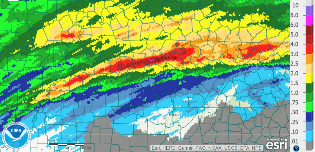 |
| February 6-7, 2019 Radar Estimated Rainfall |
Observed River Levels
 |
 |
 |
 |
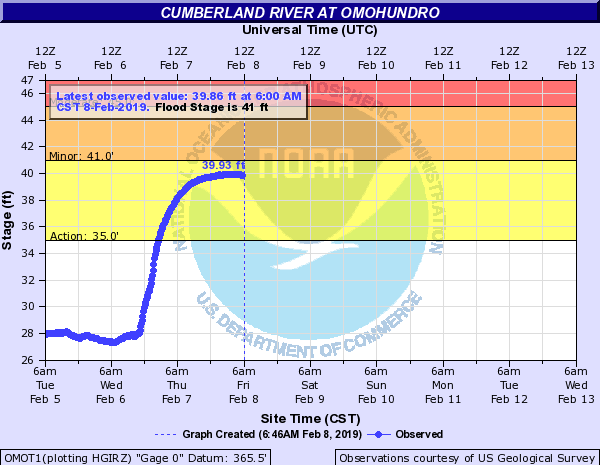
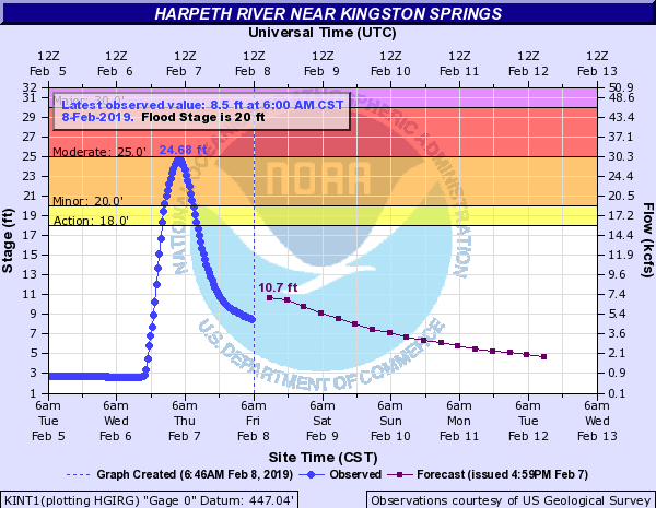
| Browns Creek near Stage Fairgrounds in Nashville | Cumberland River at Omohundro Water Plant in Nashville | Harpeth River near Kingston Springs (Cheatham County) | Piney River near Vernon (Hickman County) |
 |
Media use of NWS Web News Stories is encouraged! Please acknowledge the NWS as the source of any news information accessed from this site. |
|


 Follow us on YouTube