Mark A. Rose
Meteorologist
National Weather Service
Old Hickory, Tennessee
1. Introduction
June 22, 1969 was a typical early summer day in Macon County, Tennessee. In Lafayette, the county seat, the high temperature was 87 degrees, as well as nearby Portland, and 89 degrees at Carthage, a few miles south (NCDC). It was also Lafayette's sixth consecutive rain-free day, following a brief wet spell in mid-June.
Thirteen miles east of Lafayette on Highway 52 is the smaller community of Red Boiling Springs. Red Boiling Springs lies in a steep, narrow valley (figure 1a), through the bottom of which runs Salt Lick Creek. The center of the community also lies along the creek bottom. The head waters of Salt Lick Creek lie approximately four miles south of the center of town. At least nine smaller creeks drain into the Salt Lick before being joined by Witcher Hollow Brook near the town's center (Figures 1b and 1c). From there, Salt Lick Creek flows northward into the Barren River in southern Kentucky.
During the early morning of June 23, 1969, very heavy rainfall pounded a large area (figure 1d) of south-central Kentucky and extreme northern middle Tennessee, including the Salt Lick Creek drainage basin. The area was under a maritime tropical air mass, with a cold front to the west, and a warm front far to the north (Smith 1999). Overnight, thunderstorms formed over the area. The center of this line of storms moved very little -- only 15 miles during the six-hour period from 2:00 a.m. to 8:00 a.m. (Smith 1999). This allowed for a large rainfall accumulation.
The community of Red Boiling Springs (figure 1e), approximately 9½ miles almost due east of Lafayette, and 8 miles northwest of North Springs, appears to have been among the hardest hit. Flooding of Salt Lick Creek caused the drowning deaths of two young children in the eastern Macon County town, along with some $2 million dollars in property damage. The USDA Soil Conservation Service* reported 7.95 inches of rainfall at Red Boiling Springs in the five hours ending at 8:30 a.m. An unofficial report claimed that nearly ten inches of rain fell over the watershed of Salt Lick Creek within this period.
2. Meteorological Situation
a. Synoptic and Mesoscale
The surface analysis from the National Meteorological Center (NMC) valid at 0600 UTC (1:00 a.m. CDT) (figure 2a) on the morning of June 23 showed low pressure centered near Chicago, with a cold front trailing southwestward through southern Illinois, southeast Missouri, and the Ozark Mountains of northwest Arkansas. (Being more typical to the spring months of April and May, it is unusual to see this type of surface pattern in early summer.) Middle Tennessee was under the influence of a maritime tropical airmass, with a temperature at Nashville of 82 degrees, and a dew point of 71 degrees.
Three hours later, at 0900 UTC (figure 2b), the cold front had moved several miles eastward, and was nearly aligned along the Ohio River. Nashville's temperature had dropped a degree, to 81, while the dew point had increased a degree, to 72. Rainfall over southern Kentucky had produced an outflow of cooler, denser air there. By 1200 UTC (7:00 a.m. CDT) (figure 2c), with the cold front having shown little movement from its 0900 UTC position, the NMC analyst showed a squall line extending from southern Kentucky to a few miles west of Nashville. (Also note that the temperature at Nashville remained at 81, with the dew point having increased to 73.)
Meanwhile, the 500-millibar analysis from 1200 UTC on June 23 (NCDC) (figure 2d) showed an unusually strong 50-knot jet stretching from Little Rock to Nashville. Also note the -10 degree cold pool extending from northeast Texas into middle Tennessee, with the northern periphery relatively close to Macon County. This suggests the entire area was experiencing cold advection in the mid-levels, which would have provided additional destablization to the atmosphere. (Indeed, the 500-millibar temperature at Nashville decreased from -8.1 degrees Celsius at 0000 UTC on June 23 to -9.7 degrees 12 hours later.)
b. Sounding Data
Data obtained from rawinsonde observations from Nashville showed dramatic changes in air mass characteristics between 0000 UTC and 1200 UTC on June 23. Although the atmosphere at 0000 UTC (figure 2e) was unstable, there was relatively little moisture present, insufficient at least to support the convection that would occur during subsequent hours. However, note the unusual wind profile (again, more common during spring), with strong winds just off the surface (235/35 knots at 850 millibars (mb); 255/40 knots at 700 mb).
Twelve hours later, at 1200 UTC (figure 2f), the atmosphere showed the effects of dramatic moisture advection into the region between the surface and 469 mb. Also note further strengthening of the low-level flow, with 850 mb winds now 245/46 knots. Since precipitation had not yet begun at Nashville at the time of the observation, the latter sounding was genuinely indicative of the air mass present at the time (i.e., not rain-contaminated.)
3. The Flood
It began raining at Red Boiling Springs around 3:30 a.m. on the morning of Monday, June 23. It is not known at what time Salt Lick Creek rose out of its banks, nor at what time it crested, as accounts vary. According to one newspaper article, by 6:00 a.m. the water crested "about 5 feet above maximum flood level" (Macon 1969a). However, the same article stated that water was reported as deep as 9 feet in downtown Red Boiling Springs at 7:00 a.m. (Macon 1969a). An adjoining newspaper caption also claimed the water was "estimated to be six to 10 feet deep in several places in the business section." A newspaper photograph and caption showed a rescue team in a boat attempting a rescue of Mrs. Grady Bilbrey, mother of the two young children killed in Red Boiling Springs by the flood. One team member was standing in water that appeared to be 12 to 18 inches deep at the time (photograph not included). The team rescued her from a tree around 11:00 a.m., after having been stranded about 4 hours (Macon 1969b). It is therefore likely that Salt Lick Creek remained out of its banks at least until mid-day. (See Figures 3a-3n for various photographs of the flood and aftermath.)
Two residents of Red Boiling Springs were killed in that morning's flood. The body of Renah Louise Bilbrey, 8, was found around 2:00 p.m. that afternoon. The body of her younger sister, Jennifer Rae, 2, wasn't discovered until around 11:00 a.m. that Friday, about four miles downstream (Macon 1969c).
Overall, around 35 homes and 15 businesses in Red Boiling Springs were either destroyed or heavily damaged (Macon 1969a). Four were swept away. Many homes were removed from their foundations. Approximately 40 houses were soaked with up to four feet of water. Debris from homes were washed onto the landscape and into limbs of trees. Virtually every business in downtown Red Boiling Springs was hit heavily by the flood. Town mayor Willis Knight stated, "our biggest problem is that we are out of city water. One of the pumping stations built just six months ago is under water and our mains are all torn up. We've had floods before, but never anything like this." A depiction of the force of the flood waters is exhibited in Figure 3b -- a Trailways bus which was swept about 500 feet down the Witcher Hollow Brook and into a steel-concrete bridge.
Volunteers from many surrounding towns, including Cookeville, Carthage, Hartsville, Lawrenceburg, and Nashville, came to help with the disaster (Macon 1969a). Fresh water was brought in from Lafayette. The Red Cross set up a temporary shelter at the skating rink Monday night. A 9:00 p.m. curfew was established in order to keep spectators out of town. On Thursday, the Red Cross opened a temporary office in Lafayette (Macon 1969f).
Red Boiling Springs was not the only community in Macon County to be affected. Homes in other areas were flooded, damaged, or washed away altogether (Macon 1969d). Judge J.G. Austin asked the governor to declare the county a disaster area after assessing that 12 major bridges and 80% of all small bridges had been damaged or washed away, and roads sustained severe damage (Macon 1969e). In fact, several sections of black-topped roads were completely washed away. Road damage alone was estimated at several hundred thousand dollars.
Countywide, there was widespread property damage along virtually every stream. Cattle were washed away, as well as farm equipment, tractors, and trucks. Many tobacco crops were also completely destroyed, with extensive damage to other crops, as well. Over 100 vehicles were washed away. Macon and surrounding counties were soon declared a disaster area.
Elsewhere, Scottsville, in Allen County, Kentucky, measured 8.34 inches of rainfall during the six hours from 2:00 a.m. to 8:00 a.m., which is still a record for rainfall intensity in Scottsville (Smith 1999). Lafayette, in Macon County, Tennessee, measured 6.80 inches of rain during the morning. This still stands as the greatest one-day rainfall for Lafayette, with records going back to July 16, 1955.
Farther west, Portland measured a twenty-four hour total of 8.05 inches (NCDC). This too remains Portland's heaviest single-day precipitation event, with records there going back to 1941 (with an interruption between 1951 and 1955). A station four miles northwest of North Springs, near the Jackson-Macon County line, measured a storm total nearly identical to Lafayette -- 6.70 inches. Farther south, rainfall amounts dropped off considerably, with Carthage reporting 3.10 inches.
(June, 1969 remains Lafayette's wettest June on record, and the fifth wettest month overall, with a total of 12.44 inches (NCDC). Historically, Lafayette averages 4.52 inches of precipitation in June (through 2001). Monthly climate summaries (temperature, precipitation, and snowfall) for Lafayette are accessible from the climate data section of the National Weather Service website.)
4. Conclusions
Unfortunately, the current radar and warning network operated by the National Weather Service was not in place in 1969. The National Weather Service office at Nashville did not receive its first radar, the Weather Surveillance Radar-1957 (WSR-57), until the following year (prompted, in part, by the flood of 1969), and NOAA Weather Radio was still years away. Due to the lack of any meaningful warning system, as well as the time of day the flood occurred, the residents of Red Boiling Springs and Macon County had virtually no warning of the impending disaster. Although most flooding events are nocturnal, especially frontal events (Maddox 1979), given the unprecedented improvements in weather detection and warning coordination, the loss of life experienced in 1969 could have been prevented today. At any rate, the Red Boiling Springs flood of June 23, 1969 remains one of the most notorious and meteorologically significant events ever to occur in middle Tennessee.
__________
* A cooperative (volunteer) weather observer station was established by the Weather Bureau in Red Boiling Springs during August, 1948 (NCDC). Weather records were kept for 19 years, until August, 1967, less than two years before the flood.
Acknowledgements
The author thanks the members of the Macon County Historical Society for their recollection of this historic flood during a presentation on April 6, 2002 entitled "History of Weather in Middle Tennessee." Very special thanks go to Tina Short, Treasurer of the Historical Society, for providing the photographs and captions to the National Weather Service. The author also extends his appreciation to Henry Steigerwaldt, Science-and-Operations Officer, and Michael Murphy, Service Hydrologist, both of the National Weather Service Office in Old Hickory, for their helpful reviews and suggestions regarding this manuscript.
REFERENCES
Macon County Times, 1969a. Red Springs Cut Of By Floodwater for Several Hrs. June 26.
Macon County Times, 1969b. Girls' Mother Clings Onto Tree For Several Hours. June 26.
Macon County Times, 1969c. Body of Jennifer Rae Bilbrey Found Friday. July 3.
Macon County Times, 1969d. Other Parts Of County Also Heavily Hit By Flash Flood. June 26.
Macon County Times, 1969e. County Roads And Bridges In Extremely Bad Shape. June 26.
Macon County Times, 1969f. Red Cross Opens Temporary Office Here. June 26.
Maddox, R., C. Chappell, and L. Hoxit, 1979: Synoptic and meso-a scale aspects of flash flood events. Bull. Amer. Meteor. Soc., 60, No. 2.
National Climatic Data Center. Daily Weather Maps. Weekly Series June 23-29, 1969.
National Climatic Data Center. Surface Summaries of the Day for Lafayette, Portland, North Springs, and Carthage, Tennessee.
Smith, M. and G. Conner, 1999: Fact sheet: Record six hour rainfall in Kentucky. The Kentucky Climate Center.
TopoZone. https://www.topozone.com/.
U.S. Census Bureau. Tiger Map Server Browser.
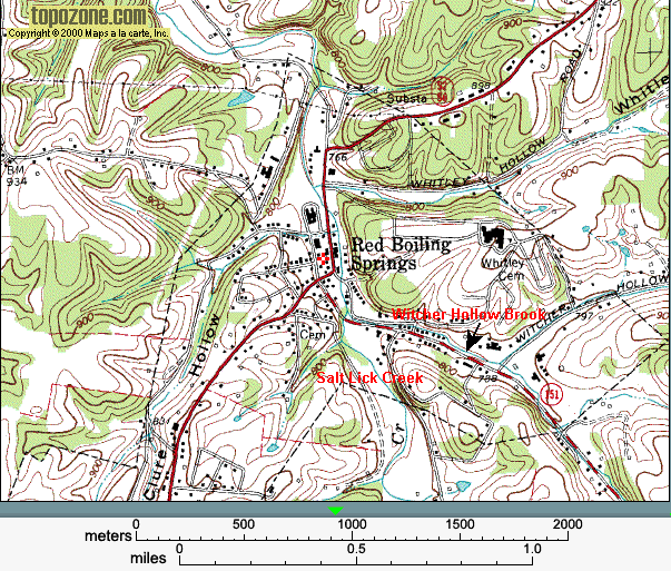
Figure 1a. Topography map of the Red Boiling Springs area (Source: topozone.com).
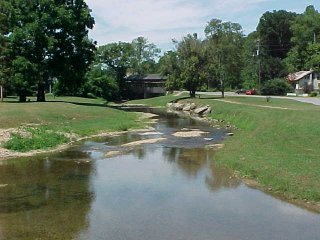
Figure 1b. August 7, 2002. Salt Lick Creek, looking toward the north at the point where Witcher Hollow Brook (entering from the bottom right) intersects Salt Lick Creek (entering from the bottom left).

Figure 1c. August 7, 2002. Witcher Hollow Brook, looking toward the east. This photograph was taken from the same bridge, looking in the same direction as Figure 3b. Main Street is to the right of the brook. Church Street is on the left.

Figure 1d. Map of the hardest-hit area, including Allen County, Kentucky and Macon County, Tennessee (Source: U.S. Census Bureau).
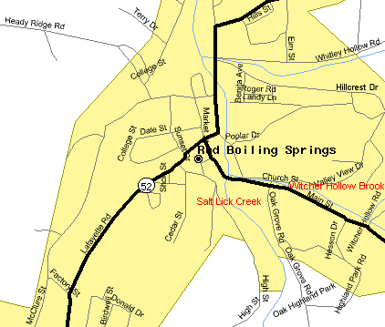
Figure 1e. Map of downtown Red Boiling Springs (Source: U.S. Census Bureau). Witcher Hollow Brook runs between Main and Church Streets. Salt Lick Creek enters the town from the south.
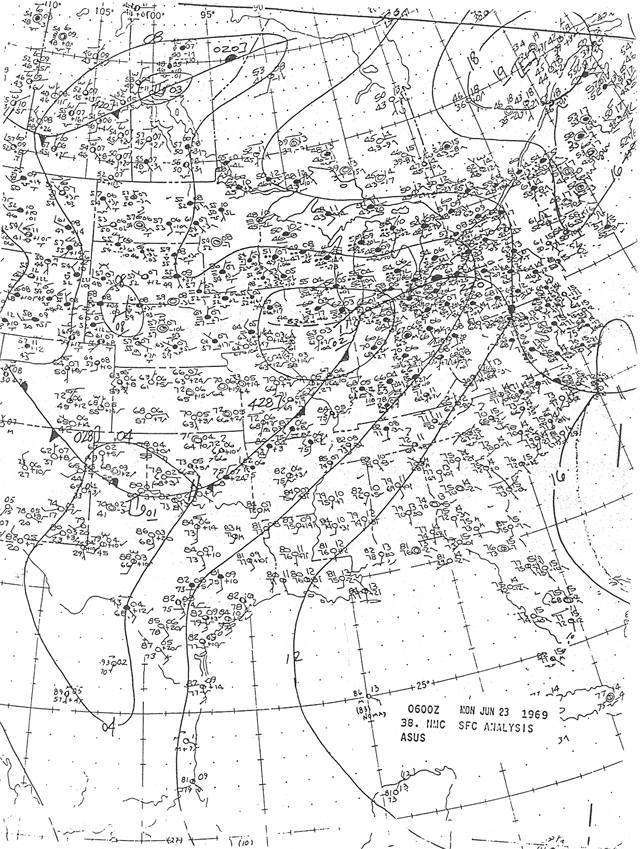
Figure 2a. Surface analysis from the National Meteorological Center (NMC) valid at 0600 UTC (1:00 a.m. CDT) on June 23, 1969.
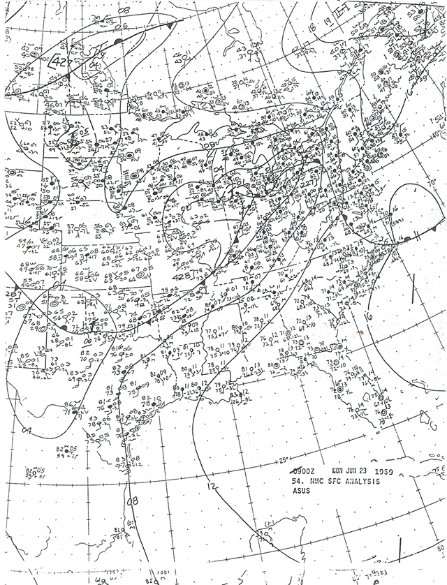
Figure 2b. Surface analysis from the National Meteorological Center (NMC) valid at 0900 UTC (4:00 a.m. CDT) on June 23, 1969.
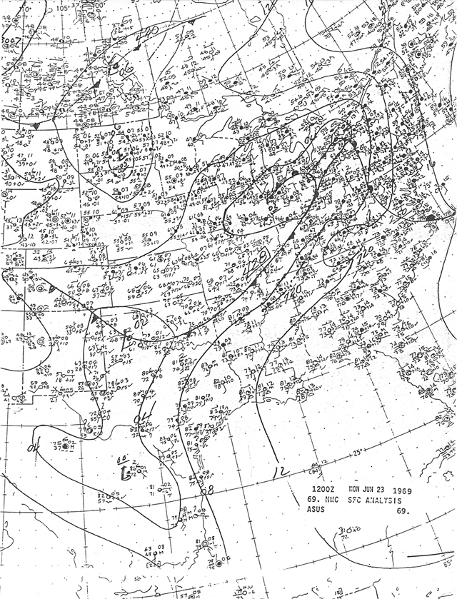
Figure 2c. Surface analysis from the National Meteorological Center (NMC) valid at 1200 UTC (7:00 a.m. CDT) on June 23, 1969.
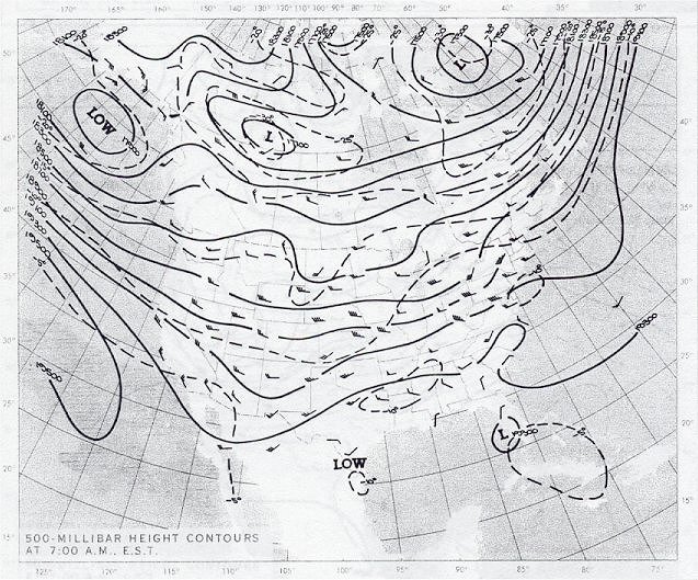
Figure 2d. 500-millibar analysis from 1200 UTC on June 23, 1969.
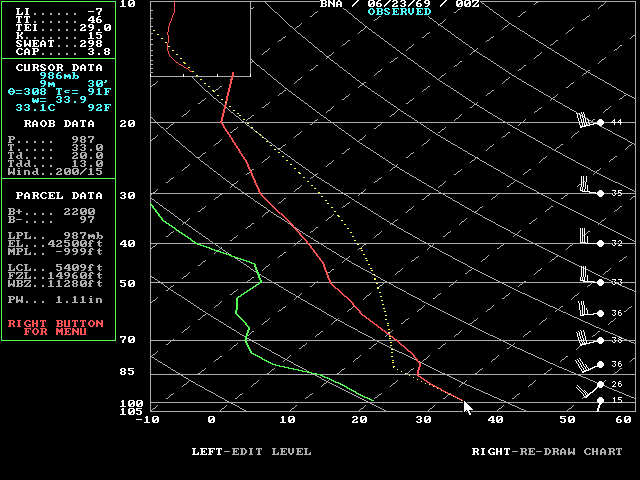
Figure 2e. Skew-t diagram from the 0000 UTC sounding on June 23, 1969 taken at Nashville, Tennessee.
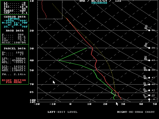
Figure 2f. Skew-t diagram from the 1200 UTC sounding on June 23, 1969 taken at Nashville, Tennessee.
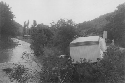
Figure 3a. June 24, 1969. Two miles south of Lafayette. Trailer destroyed by the flood, located on Highway 10 south of town. Photographer: C.A. Hogan. Credit: USDA Soil Conservation Service.
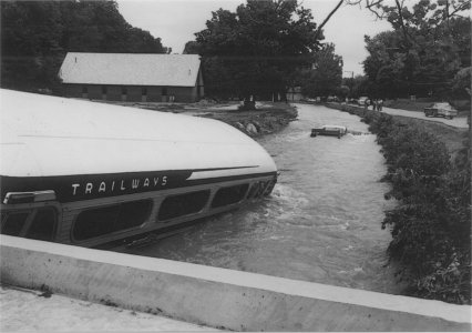
Figure 3b. June 23, 1969. This Trailways bus was swept downstream and lodged onto a steel-concrete bridge. Also note the submerged pickup truck upstream. Photographer: J.L. Bilyeu. Credit: USDA Soil Conservation Service.
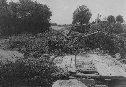
Figure 3c. June 24, 1969. Flood damage. Bridge washed out below Bethany on Salt Lick Creek. Photographer: C.A. Hogan. Credit: USDA Soil Conservation Service.
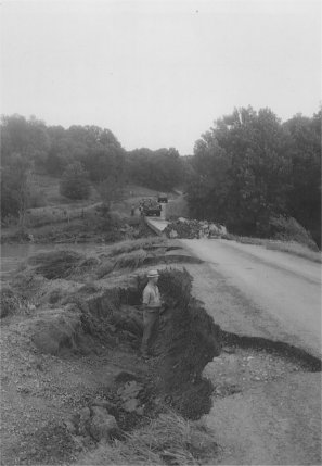
Figure 3d. June 24, 1969. Flood damage three miles east of Rocky Mound. Bridge washed out on Long Creek below town. Photographer: William Thurmond. Credit: USDA Soil Conservation Service.

Figure 3e. June 23, 1969. Macon County. House in background was swept from foundation in foreground and lodged in trees along stream banks. Photographer: J.L. Bilyeu. Credit: USDA Soil Conservation Service.

Figure 3f. June 23, 1969. Macon County. Rescue team worker standing on top of an automobile in Salt Lick Creek at Highway 52 bridge in the business district as many people watch the rescue operations. Photographer: A.G. Fuqua. Credit: USDA Soil Conservation Service.

Figure 3g. June 24, 1969. Flood damage four miles northwest of Red Boiling Springs. Bridge washed out below Bethany on Salt Lick Creek. Photographer: C.A. Hogan. Credit: USDA Soil Conservation Service.
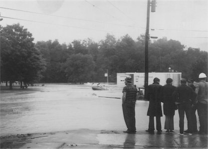
Figure 3h. June 23, 1969. Flood damage. Downtown business district in Red Boiling Springs. Citizens observe flood water in front of Macon Bank and Trust Company. Photographer: A.G. Fuqua. Credit: USDA Soil Conservation Service.

Figure 3i. June 23, 1969. Aftermath of cloudburst. Note huge chunks of pavement ripped up by the force of the flood. Photographer: J.L. Bilyeu. Credit: USDA Soil Conservation Service.
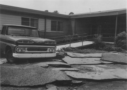
Figure 3j. June 23, 1969. Pickup truck swept onto access ramp in front of rest home. Note pavement strewn about by the force of the floodwaters. Photographer: J.L. Bilyeu. Credit: USDA Soil Conservation Service.
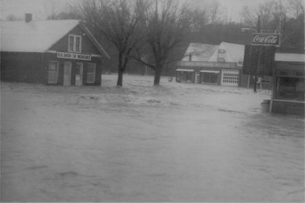
Figure 3k. June 23, 1969. Downtown Red Boiling Springs on the day of the flood. Credit: USDA Soil Conservation Service.
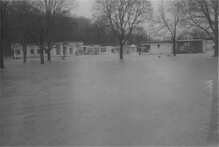
Figure 3l. June 23, 1969. Downtown Red Boiling Springs on the day of the flood. Credit: USDA Soil Conservation Service.
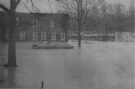
Figure 3m. June 23, 1969. Downtown Red Boiling Springs on the day of the flood. Credit: USDA Soil Conservation Service.
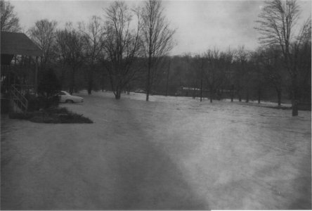
Figure 3n. June 23, 1969. Downtown Red Boiling Springs on the day of the flood. Credit: USDA Soil Conservation Service.


 Follow us on YouTube