National Weather Service United States Department of Commerce

Severe Thunderstorms in West-Central Texas; Critical Fire Weather Threat in the Rockies and Plains

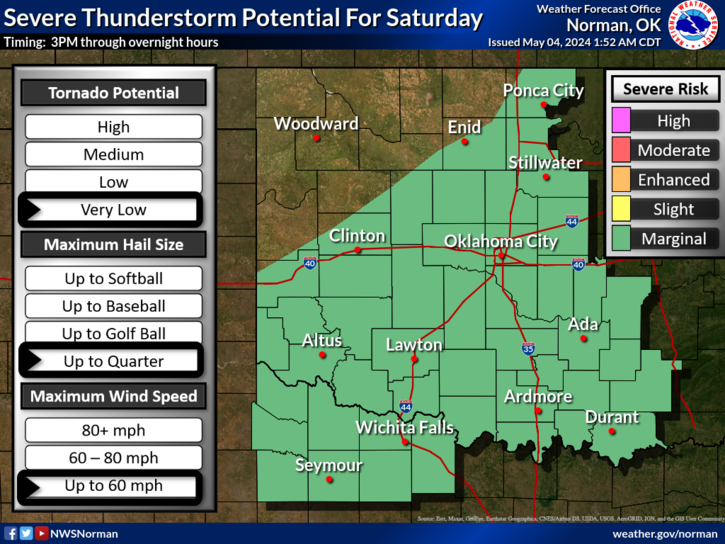
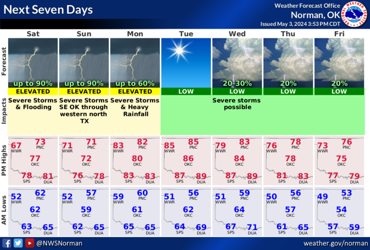
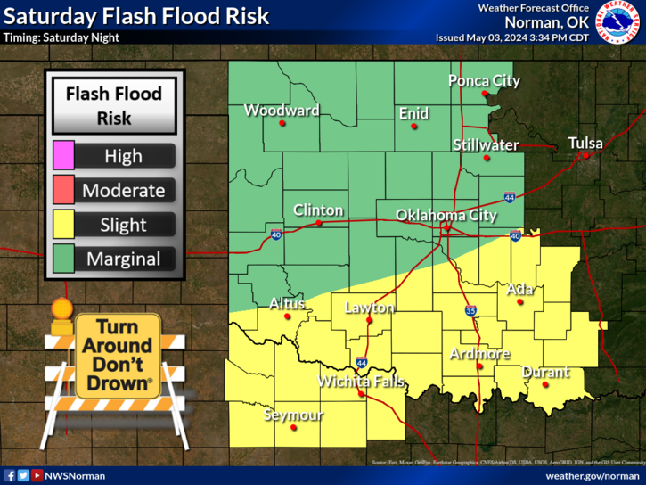
Isolated strong to severe thunderstorms capable of producing large hail and damaging wind gusts will be possible this evening across west-central Texas. Elevated to Critical fire weather conditions will persist across the southern Rockies and portions of the southern Plains through this weekend. Read More >

Click a location below for detailed forecast.

Last Map Update: Wed, Apr. 24, 2024 at 11:00:12 pm CDT

National Weather Service Dodge City, KSNational Weather Service Wichita, KansasNational Weather Service Tulsa, OK
National Weather Service Amarillo, TXZoom
Out

National Weather Service Tulsa, OK
National Weather Service Lubbock, TXNational Weather Service Fort Worth/Dallas, TXNational Weather Service Shreveport, LA

Storms are expected to form in the Oklahoma and Texas panhandle late Thursday afternoon and spread east into Oklahoma and north Texas during the evening hours. Storms will continue to spread east overnight with a continuing potential of severe weather. The main threat will be large hail and damaging winds, but there is the potential of tornadoes as well.
The will be a medium potential for tornadoes across western Oklahoma on Thursday evening with at least a low potential of tornadoes eastward into central Oklahoma and western north Texas as storms spread east overnight into early Friday morning.
There is an enhanced risk of severe thunderstorms across a large portion of Oklahoma and north central Texas on Saturday, with at least a slight risk over the entire area on Saturday. Damaging wind gusts, large hail and tornadoes are all possible.

 Current Weather Observations...
Location Time
(CDT)
Weather Vsby.
(SM)
Temp.
(ºF)
Dewpt.
(ºF)
Hum.
(%)
Wind
(mph)
Wind Chill / Heat Index
(ºF)
Pres.
(in)
Oklahoma City, OK21:52Overcast10685767ESE 10-30.04
Norman, OK21:55Overcast10716274E 6-30.03
Stillwater, OK21:53Partly Cloudy10695152ESE 9-30.04
Lawton, OK21:53Overcast10726681ESE 12-30.02
Wichita Falls, TX21:52Overcast10716786ESE 9-30.00
Ponca City, OK21:53Partly Cloudy10664241ESE 9-30.04
Enid, OK21:55Mostly Cloudy10655364ESE 9-30.01
Alva, OK22:15Overcast10685052SE 12-30.03
Woodward, OK21:50Overcast10645367E 10-30.05
Gage, OK21:53Overcast9686075SSE 10-30.02
Watonga, OK21:55Overcast10665566E 10-30.06
Clinton, OK21:53Overcast10696380SE 9-30.03
Weatherford, OK22:15Overcast10696277SE 10-30.03
Hobart, OK21:53Mostly Cloudy10716581SE 13-30.01
Altus, OK22:15Overcast10696688ESE 13G18-29.99
Frederick, OK21:53Overcast10716786ESE 10-29.97
Ardmore, OK21:50Overcast10716683CALM-30.03
Ada, OK22:15Overcast10716683SSE 9-30.05

Local Weather History For April 24th...
An unusual tornado occurred on this day in 2006. In the town of El
Reno, numerous storm spotters, including 3 media helicopters, spotted
an anti-cyclonic tornado. It touched down 5 miles southwest of El
Reno, while at the same time, a cyclonic tornado was moving across
western El Reno. The anti-cyclonic tornado moved east southeast
through the El Reno Regional Airport, causing extensive damage to the
two large hanger buildings and ten aircraft. Five of the ten aircraft
were claimed a total loss. Total damage to the airport was estimated
at $1.5 million.

Text Product Selector (Selected product opens in current window)
Weather Observations Area Forecast Discussion Air Quality Forecasts Hydrology Information Frequently Asked Questions Social Media
Observations Discussion Air Quality Hydrology FAQ Social Media
 
Submit a Storm Report Graphical Weather Forecasts Aviation Weather Forecasts Climate Data Storm Data Weather Radio Information
Storm Reports Gridded Forecast Aviation Climate Storm Data Weather Radio  
 
Satellite Information Hourly Weather Forecast Fire Weather Information Past Weather Events StormReady Skywarn/Storm Spotters
Satellite Hourly Forecast Fire Weather Past Events StormReady Storm Spotters