National Weather Service United States Department of Commerce

Severe Thunderstorms in Northwest Texas; Dry Conditions and Gusty Winds Across Colorado

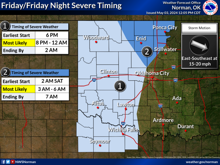
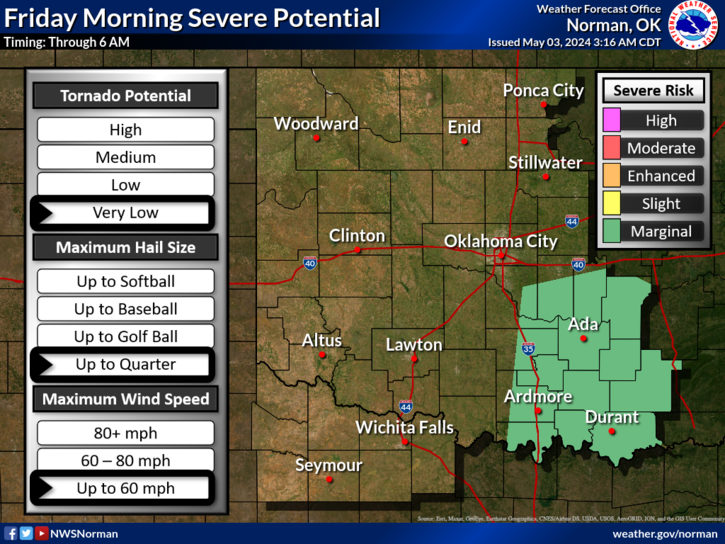
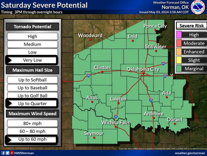
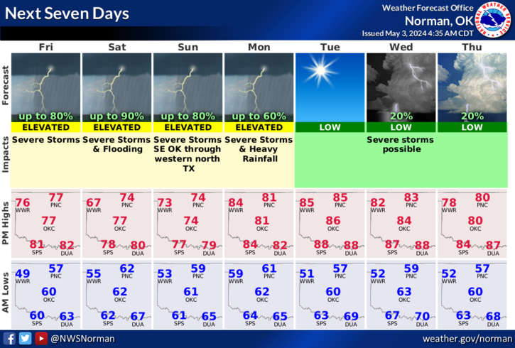
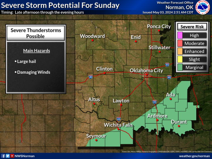
A few severe thunderstorms capable of producing large hail and gusty winds will be possible this afternoon and evening across northwest Texas. Dry conditions and gusty winds will persist across southern Colorado today. Read More >

Click a location below for detailed forecast.

Last Map Update: Tue, Apr. 23, 2024 at 12:46:10 pm CDT

National Weather Service Dodge City, KSNational Weather Service Wichita, KansasNational Weather Service Tulsa, OK
National Weather Service Amarillo, TXZoom
Out

National Weather Service Tulsa, OK
National Weather Service Lubbock, TXNational Weather Service Fort Worth/Dallas, TXNational Weather Service Shreveport, LA

A few severe thunderstorms are possible on Tuesday evening, posing a risk for damaging winds and large hail.
The severe weather risk is marginal (level 1 of 5), but could come in two rounds. The first round could be from sunrise Wednesday morning to around 11 AM, and the second round from around 9 PM overnight through sunrise Thursday morning.
Storms are expected to form in the Oklahoma and Texas panhandle late Thursday afternoon and spread east into Oklahoma and north Texas during the evening hours. Storms will continue to spread east overnight with a continuing potential of severe weather. The main threat will be large hail and damaging winds, but there is the potential of tornadoes as well.
There is a slight risk of severe weather across the entire area on Saturday. Damaging wind gusts, large hail and tornadoes are all possible.
Elevated fire weather conditions with gusty winds and low humidity are expected Thurday and Friday afternoons in western Oklahoma and western north Texas, with near-critical conditions most likely in northwest and west central Oklahoma.
Near or above-average temperatures are expected over the next week, with the exception of Wednesday which will be cooler in many areas with clouds and scattered showers and storms.

 Current Weather Observations...
Location Time
(CDT)
Weather Vsby.
(SM)
Temp.
(ºF)
Dewpt.
(ºF)
Hum.
(%)
Wind
(mph)
Wind Chill / Heat Index
(ºF)
Pres.
(in)
Oklahoma City, OK11:52Partly Cloudy10725555SW 17G26-29.88
Norman, OK11:45Clear10715353S 17G24-29.88
Stillwater, OK11:53Clear10775444SW 15G25-29.87
Lawton, OK11:53Clear10725759SSW 15G25-29.89
Wichita Falls, TX11:52Mostly Clear10705763SSW 16G30-29.90
Ponca City, OK11:53Clear10745246VRB 5-29.87
Enid, OK11:55Mostly Clear10755143WNW 8-29.84
Alva, OK12:35Clear10735146NNE 23G32-29.91
Woodward, OK12:10Lightning Observed10715046NNE 24G33-29.95
Gage, OK11:53Clear10765141N 26G37-29.91
Watonga, OK12:15Clear10745246SSW 10G20-29.91
Clinton, OK11:53Clear10705354SW 10-29.89
Weatherford, OK12:35Clear10745246SW 7-29.89
Hobart, OK11:53Clear10745551SSW 20-29.88
Altus, OK12:15Mostly Cloudy10735349SSW 15G21-29.89
Frederick, OK11:53Clear10745755SW 18G25-29.87
Ardmore, OK11:50Clear10715964S 21-29.93
Ada, OK12:35Clear10735960S 13G25-29.91

Local Weather History For April 23rd...
Thunder was not heard officially in Oklahoma City during April 1989.
That was the only April in the history of Oklahoma City, since 1891,
that passed with no observation of thunder on any day of the month.

Text Product Selector (Selected product opens in current window)
Weather Observations Area Forecast Discussion Air Quality Forecasts Hydrology Information Frequently Asked Questions Social Media
Observations Discussion Air Quality Hydrology FAQ Social Media
 
Submit a Storm Report Graphical Weather Forecasts Aviation Weather Forecasts Climate Data Storm Data Weather Radio Information
Storm Reports Gridded Forecast Aviation Climate Storm Data Weather Radio  
 
Satellite Information Hourly Weather Forecast Fire Weather Information Past Weather Events StormReady Skywarn/Storm Spotters
Satellite Hourly Forecast Fire Weather Past Events StormReady Storm Spotters