National Weather Service United States Department of Commerce

Active Pattern for the Center of the Nation

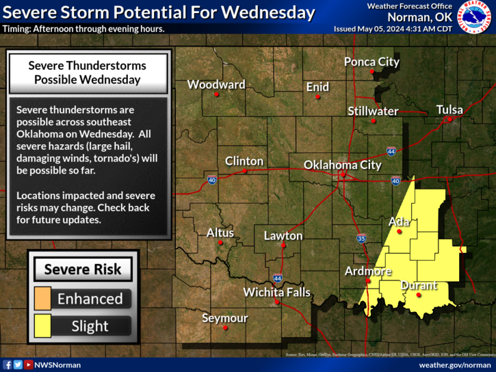
Critical fire weather conditions, severe thunderstorms capable of producing severe wind gusts, large hail, strong tornadoes and heavy rainfall remain on tap for the central U.S. this evening. Flash flooding is also possible for portions of the Plains and Mississippi Valley. Very large hail up to 3 inches in diameter will be possible this evening across western Kansas. Read More >

Click a location below for detailed forecast.

Last Map Update: Thu, Apr. 25, 2024 at 6:57:23 pm CDT

National Weather Service Dodge City, KSNational Weather Service Wichita, KansasNational Weather Service Tulsa, OK
National Weather Service Amarillo, TXZoom
Out

National Weather Service Tulsa, OK
National Weather Service Lubbock, TXNational Weather Service Fort Worth/Dallas, TXNational Weather Service Shreveport, LA

Storms are expected to form in the Oklahoma and Texas panhandle Thursday evening and spread east into Oklahoma and north Texas during the late evening and overnight hours. The main threat will be large hail and damaging winds, but there is the potential of tornadoes as well.
Severe weather may begin as early as 8 PM across western Oklahoma and western north Texas, although the most likely onset will be closer to 11 PM tonight. Storms will move northeast at 35 to 45 mph. Storms are expected to persist across southeastern Oklahoma as late as 8 AM to 9 AM Friday morning.
There is an enhanced risk of severe thunderstorms across a large portion of Oklahoma and north central Texas on Saturday, with at least a slight risk over the entire area on Saturday. Damaging wind gusts, large hail and tornadoes are all possible. The primary time of severe weather potential would be from 12 PM through the overnight hours until sunrise Sunday morning, but there is some potential of severe weather earlier before 4 PM Saturday.
A few severe thunderstorms are possible by Sunday afternoon into evening. Uncertainty in coverage and location remains, so check back!

 Current Weather Observations...
Location Time
(CDT)
Weather Vsby.
(SM)
Temp.
(ºF)
Dewpt.
(ºF)
Hum.
(%)
Wind
(mph)
Wind Chill / Heat Index
(ºF)
Pres.
(in)
Oklahoma City, OK17:52Overcast10756468S 25G40-29.74
Norman, OK17:45Overcast10756469SSE 21G31-29.75
Stillwater, OK17:53Light Rain10816354S 24G37-29.73
Lawton, OK17:53Overcast10746778SSE 14G23-29.74
Wichita Falls, TX18:01Overcast10756878S 18G30-29.73
Ponca City, OK17:53Overcast10806355SSE 16G24-29.74
Enid, OK17:55Mostly Cloudy10796358S 21-29.68
Alva, OK18:35Overcast10786665S 15G24-29.66
Woodward, OK18:10Overcast10756060S 25G29-29.68
Gage, OK18:30Mostly Cloudy10756366S 28G40-29.64
Watonga, OK18:15Overcast10756468S 16G26-29.73
Clinton, OK18:25Overcast10736473SSE 28G41-29.70
Weatherford, OK18:35Overcast10746471S 20G29-29.71
Hobart, OK17:53Overcast10756673S 26G35-29.71
Altus, OK18:15Overcast10756673SSE 25G32-29.69
Frederick, OK17:53Overcast10756878SSE 21G30-29.70
Ardmore, OK17:50Mostly Cloudy10756878SSE 12-29.81
Ada, OK18:15Overcast10756878S 15G24-29.80

Local Weather History For April 25th...
The first known official tornado outbreak in central Oklahoma came on
April 25, 1893. On that day, at least five strong or violent
tornadoes struck central Oklahoma. One twister moved through northern
Cleveland County, destroying 30 homes. This tornado was more than
one-mile wide at times.

Text Product Selector (Selected product opens in current window)
Weather Observations Area Forecast Discussion Air Quality Forecasts Hydrology Information Frequently Asked Questions Social Media
Observations Discussion Air Quality Hydrology FAQ Social Media
 
Submit a Storm Report Graphical Weather Forecasts Aviation Weather Forecasts Climate Data Storm Data Weather Radio Information
Storm Reports Gridded Forecast Aviation Climate Storm Data Weather Radio  
 
Satellite Information Hourly Weather Forecast Fire Weather Information Past Weather Events StormReady Skywarn/Storm Spotters
Satellite Hourly Forecast Fire Weather Past Events StormReady Storm Spotters