
There is an Enhanced Risk (Level 3 of 5) for severe thunderstorms Tuesday with threats for significant severe hail and tornado potential over southern Iowa into northern Missouri and west-central Illinois. Elevated to critical fire weather is possible Tuesday due to gusty winds and dry conditions over parts of the southern High Plains and northeastern Montana. Read More >

| Bryan County, OK Tornadoes Prior to 1950 | |||||||||
| # | Date | Time (CST) |
Path Length (miles) |
Path Width (yards) |
F-Scale | Killed | Injured | County | Path |
|---|---|---|---|---|---|---|---|---|---|
| 12/17/1887 | 0 | 0 | Bryan | Fort Washita | |||||
| 05/15/1896 | 1630 | 0 | 0 | Bryan | Near Kemp and "Joel" | ||||
| 05/20/1916 | 2130 | 10 | 100 | 9 | 28 | Bryan | Kemp City | ||
| 04/09/1919 | 0115 | 11 | 20 | Bryan | TX - near Roberta - near Durant | ||||
| 04/20/1927 | 1730 | 75 | 0 | 1 | Bryan | Near Caddo | |||
| 10/15/1933 | 1600 | 1 | 50 | 0 | 0 | Bryan | Brown (13 NW Durant) | ||
| 03/28/1938 | 1330 | 0.75 | 35 | 0 | 0 | Bryan | Pirtle (5 E Durant) | ||
| 04/08/1943 | 930 | 1 | 100 | 0 | 2 | Bryan | Calera | ||
| 05/10/1943 | 300 | 1 | 0 | 0 | Bryan | 1 SW Durant | |||
| 03/16/1945 | 2230 | n | 1 | 6 | Bryan | Near Old Kemp and Achille | |||
| 04/30/1949 | 1731 | 55 | 440 | 1 | 3 | Bryan/ Choctaw | Near Utica - "Nelson" (6 N Soper) (not continuous) | ||
| Bryan County, OK Tornadoes (1950-Present*) | |||||||||
| # | Date | Time (CST) |
Path Length (miles) |
Path Width (yards) |
F-Scale | Killed | Injured | County | Path |
| 1 | 05/09/1951 | 2020 | 15 | 100 | F2 | 0 | 1 | Bryan/ Marshall/ Johnston | Western Bryan County and eastern Marshall county - Nida - NW of Kenefic |
| 2 | 09/20/1954 | 2000 | 5 | 10 | F2 | 0 | 1 | Bryan | Durant |
| 3 | 04/23/1955 | 0230 | 0.1 | 10 | F1 | 0 | 0 | Bryan | near Durant |
| 4 | 05/26/1955 | 0520 | 5 | 50 | F0 | 0 | 0 | Bryan | near Durant |
| 5 | 04/28/1956 | 2200 | 28 | 300 | F2 | 0 | 0 | Bryan/ Atoka/ Pushmataha | near Matoy - Antlers |
| 6 | 04/02/1957 | 1758 | 8 | 200 | F4 | 3 | 3 | Bryan | Calera - Durant - N of Durant |
| 7 | 05/24/1957 | 1040 | 0.1 | 10 | F1 | 0 | 0 | Bryan | Lake Texoma (near 'Willow Springs') |
| 8 | 10/04/1959 | 0725 | 4 | 200 | F2 | 0 | 2 | Bryan | 2 W Yuba |
| 9 | 04/03/1964 | 0635 | 17 | 200 | F3 | 0 | 1 | Marshall/ Bryan | Near Woodville - Lake Texoma - 2 W Cobb |
| 10 | 06/14/1969 | 0300 | 13 | 100 | F2 | 0 | 0 | Bryan | Near Colbert - 5 E Durant |
| 11 | 10/08/1970 | 0830 | 1 | 100 | F1 | 0 | 1 | Bryan | W edge of Durant |
| 12 | 03/12/1971 | 1645 | 42 | 250 | F3 | 0 | 4 | Marshall/ Bryan | 10 SW Madill - Cartwright - Colbert - Achille - Yuba |
| 13 | 04/20/1972 | 1925 | 9 | 50 | F2 | 0 | 0 | Bryan | Mead - 5 NE Durant |
| 14 | 05/25/1974 | 1930 | 9 | 1500 | F2 | 0 | 0 | Bryan | 6 S- 3 E Durant |
| 15 | 08/26/1974 | 1820 | 1 | 100 | F1 | 0 | 0 | Bryan | Just E and N of Durant |
| 16 | 04/02/1980 | 1853 | 4 | 60 | F2 | 0 | 0 | Bryan | 3 N Durant |
| 17 | 05/23/1981 | 1858 | 10 | 100 | F3 | 0 | 0 | Bryan | 7 NW of Durant - W edge of Durant - near Calera |
| 18 | 05/23/1981 | 1900 | 0.1 | 10 | F1 | 0 | 0 | Bryan | Lake Texoma |
| 19 | 04/02/1982 | 1425 | 0.5 | 30 | F2 | 0 | 1 | Bryan | Near Silo |
| 20 | 04/02/1982 | 1505 | 0.5 | 10 | F2 | 0 | 0 | Bryan | N of Bokchito |
| 21 | 02/14/1987 | 2225 | 0.2 | 50 | F1 | 0 | 0 | Bryan | Armstrong |
| 22 | 03/21/1991 | 1802 | 5 | 150 | F2 | 0 | 0 | Bryan | 1 NW Durant- 1 NE Armstrong |
| 23 | 03/21/1991 | 1952 | 3 | 100 | F0 | 0 | 0 | Bryan | 5 NE Bokchito |
| 24 | 05/11/1992 | 1524-1527 | 2 | 50 | F0 | 0 | 0 | Marshall/ Bryan | 5 E- 6 E Kingston |
| 25 | 05/11/1992 | 1625 | 1 | 100 | F2 | 0 | 0 | Bryan | 2 NW Albany |
| 26 | 09/21/1992 | 1555 | 0.1 | 30 | F0 | 0 | 0 | Bryan | 2 S Caddo |
| 27 | 04/26/1994 | 1718 | 9 | 40 | F1 | 0 | 0 | Bryan | Near Kemp- Yuba |
| 28 | 04/26/1994 | 1735 | 1.5 | 40 | F0 | 0 | 0 | Bryan | Near Wade |
| 29 | 04/11/2001 | 0347 | 0.3 | 25 | F0 | 0 | 0 | Bryan | 4 W Brown |
| 30 | 09/08/2010 | 1305 | 0.1 | 25 | EF1 | 0 | 1 | Bryan | Colbert |
| 31 | 05/09/2015 | 1825-1835 | 5 | 200 | EF1 | 0 | 0 | Bryan | 1 SSW Silo - 5 NNW Durant |
| 32 | 05/25/2015 | 1342-1420 | 19 | 700 | EF3 | 1 | 1 | Bryan/ Atoka | 2.5 WSW Blue - 3 E Caney |
| 33 | 05/09/2016 | 1722-1742 | 14 | 3100 | EF3 | 0 | 2 | Bryan/ Choctaw | 3.5 ESE Bennington - 6.5 ESE Boswell |
| 34 | 04/30/2019 | 2007-2042 | 28 | 1400 | EF3 | 2 | 16 | Bryan/ Atoka | 2 SSE Blue - near Bentley - near Lane |
| 35 | 04/22/2020 | 1632-1645 | 5 | 500 | EF1 | 0 | 0 | Bryan | 4 WNW Armstrong - 3 NE Armstrong |
| 36 | 04/22/2020 | 1652-1653 | 1.2 | 30 | EF1 | 0 | 0 | Bryan | 4 SSE - 5 SE Caddo |
| 37 | 05/05/2022 | 1253-1253 | 0.3 | 20 | EF0 | 0 | 0 | Bryan | Durant (2 NW Downtown) |
| 38 | 11/04/2022 | 1230-1234 | 3.4 | 40 | EF1 | 0 | 0 | Bryan | 2 SW Calera - Calera - 1 N Calera |
| Date | Time (CST) |
Path Length (miles) |
Path Width (yards) |
F-Scale | Killed | Injured | County | Path | |
|---|---|---|---|---|---|---|---|---|---|
| 05/09/1951 | 2020 | 15 | 100 | F2 | 0 | 1 | Bryan/ Marshall/ Johnston | Western Bryan County and eastern Marshall county - Nida - NW of Kenefic | |
|
This tornado caused damage along a 15-mile path in Bryan, Marshall, and Johnston counties, and especially to cottages at the Cumberland Oil Field camp in eastern Marshall County. Total property damages were listed at $40,000. |
|||||||||
| 09/20/1954 | 2000 | 5 | 10 | F2 | 0 | 1 | Bryan | Durant | |
|
A tornado and severe thunderstorms caused damage estimated at $50,000 in the vicinity of Durant between 8:00 pm CST and 9:30 pm CST on September 20th. Damage occurred to a livestock commission barn, a drive-in theater, a box factory, utility lines, television antennas, trees, and roofs on houses and barns. |
|||||||||
| 04/02/1957 | 1758 | 8 | 200 | F4 | 3 | 3 | Bryan | Calera - Durant - N of Durant | |
|
The touched down in Bryan County at the northeast edge of Calera where a drive-in theater and a large stock barn were destroyed. The tornado moved northeast and caused extensive damage to homes and businesses in the city of Durant. Nine blocks in the southern and southeastern portions of the city were destroyed while other damage occurred in 20 more blocks. About 135 homes and 20 businesses were destroyed or damaged. One home was completely leveled about 5 miles north-northeast of Durant near the end of the tornado's damage path. Two people died when the roof of service station collapsed. The tornado killed 3 people and three others were injured. |
|||||||||
| 10/04/1959 | 0725 | 4 | 200 | F2 | 0 | 2 | Bryan | 2 W Yuba | |
|
A tornado struck west of Yuba in Bryan County at 7:25 pm CST. Outbuildings were destroyed on one farm and another farmstead was almost completely destroyed. Two of four people sheltering in one house were injured by flying debris when the house was almost completely destroyed. |
|||||||||
| 04/03/1964 | 0635 | 17 | 200 | F3 | 0 | 1 | Marshall/ Bryan | Near Woodville - Lake Texoma - 2 W Cobb | |
|
This tornado began near Woodville in Marshall County and moved northeastward, eventually striking the Lake Texoma Lodge area, where the damages incurred were $125,000. The Texoma State Park building was unroofed, 9 cabins were damaged while a gold course maintenance building and state-owned Catfish Bay boathouse were demolished. Several of the damaged cabins were also located in the Catfish Bay area. The Catfish Bay marina was also destroyed. A number of power poles and utility lines were blown down by the tornado in the lodge area. Damage was also reported at the Newberry Creek resort where boat docks were damaged. The tornado crossed Lake Texoma into Bryan County and continued to the northeast before dissipating 2 miles west of Cobb. U.S. Highway 70 near the Roosevelt Bridge (10 miles west of Durant) was closed temporarily due to storm debris (including utility lines and snapped power poles) landing on the road. |
|||||||||
| 10/08/1970 | 0830 | 1 | 100 | F1 | 0 | 1 | Bryan | W edge of Durant | |
|
A tornado struck the western edge of Durant and damaged several barns, several buildings, and 3 mobile homes. The local masonic lodge building was unroofed while a church steeple was toppled and its roof damaged. The roof from the masonic lodge was lifted and blown into the 3 mobile homes. A man was slightly injured when the tornado damaged his mobile home just south of Durant. |
|||||||||
| 03/12/1971 | 1645 | 42 | 250 | F3 | 0 | 4 | Marshall/ Bryan | 10 SW Madill - Cartwright - Colbert - Achille - Yuba | |
|
This tornado began at 4:45 pm CST 10 miles southwest of Madill in Marshall County on March 12th where 6 homes and several outbuildings were destroyed. About 100 cattle were also killed in the area. One person was injured when they were cut by flying glass. The path of the known damage southwest of Madill was approximately 200 yards wide. The storm continued to the east-southeast and the next known area of damage was located about 4 miles north of Willis in Marshall County where 3 houses were destroyed and several more were damaged. A grocery store was also damaged and several race horses were killed. More damage occurred at Cartwright in Bryan County where a house was damaged and electrical service was knocked out. Damage also occurred at Colbert in Bryan County where a semi-trailer truck was overturned and several mobile homes were damaged. The most extensive damage occurred at Achille in Bryan County as the tornado entered the area around 5:43 pm CST. Light to heavy damage occurred within a 10-block area in Achille. Several businesses were destroyed or damaged, and the roof of the elementary school was ripped off. The high school's vocation agriculture building was totally destroyed, a bus barn was splintered with the buses left standing inside, and the new junior high building was damaged. A total of 25 homes and 6 mobile homes were damaged or destroyed. Three people were injured in Achille, including a woman who incurred a broken leg after she was hit by flying debris while rushing to a storm shelter. Within Achille, the damage path was one mile long and 300 yards wide. The last report of damage was at Yuba in Bryan County where barns were damaged and a steeple was snapped over at a church. The total storm damage amount was $400,000. Two funnels were also sighted in Marshall County and 1-inch hail fell near Kingston and large hail fell at McBride in Marshall County. |
|||||||||
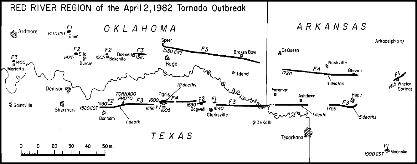
| 04/02/1982 | 1425 | 0.5 | 30 | F2 | 0 | 1 | Bryan | Near Silo | |
|
A tornado touched down briefly in the Silo area where 4 mobile homes and 123 houses were damaged. One minor injury was reported and damage was estimated at $500,000. This tornado was part of the April 2, 1982 tornado outbreak which produced 56 tornadoes in 11 states, killing 30 persons and injuring another 383 people. A tornado damage path map shows the damage paths in southeastern Oklahoma, northeastern Texas, and southwestern Arkansas. |
|||||||||
| 09/08/2010 | 1305 | 0.1 | 25 | EF1 | 0 | 1 | Bryan | Colbert | |
|
The remnants of Tropical Storm Hermine moved north into southern and central Oklahoma, bringing with it heavy rain and three tornadoes. The most significant impact with this storm came from three tornadoes. The most significant tornado occurred near Colbert in Bryan County. Two homes sustained moderate damage and two trucks were overturned. One of the drivers sustained minor injuries while in the truck. Fifteen steel transmission lines were also downed. At least 1000 people were without power due to the damage. |
|||||||||
| 05/25/2015 | 1342-1420 | 19 | 700 | EF3 | 1 | 1 | Bryan/ Atoka | 2.5 WSW Blue - 3 E Caney | |
|
A strong tornado developed in Bryan County near the intersection of Old U.S. Highway 70 and Pirtle Road, 2.5 miles west-southwest of Blue. The tornado moved northeast and destroyed a mobile home north of Blue where a 48-year-old woman was killed. This was one of a few mobile homes that were destroyed as the tornado moved through Bryan County (DI 3, DOD 8-9). Other homes also suffered roof damage or other damage from falling trees . From north of Blue, the tornado turned to the north and moved into Atoka County. |
|||||||||
| 05/09/2016 | 1722-1742 | 14 | 3100 | EF3 | 0 | 2 | Bryan/ Choctaw | 3.5 ESE Bennington - 6.5 ESE Boswell | |
|
Severe thunderstorms developed along and ahead of a dry line across central Oklahoma during the afternoon of May 9th. The storms moved across eastern Oklahoma during the evening hours. Prior to the storms moving into the area, the atmosphere ahead of the dry line in eastern Oklahoma had become very unstable. This instability, combined with very strong wind shear associated with a strong trough of low pressure that moved into the Southern Plains from the Southern Rockies, resulted in the development of supercell thunderstorms. One of these supercells produced multiple tornadoes as it tracked along and near an outflow boundary from morning thunderstorms, which had settled across southeastern Oklahoma by the afternoon. One of the tornadoes was long-lived and damaging. In addition to the tornadoes in southeastern Oklahoma, the severe thunderstorms produced hail up to golfball size and damaging wind gusts across other portions of eastern Oklahoma. A tornado developed southeast of Bennington, and quickly became very large as it moved east-northeast. Widespread destruction of trees was observed across eastern Bryan County. The tornado moved into Choctaw County southwest of Boswell. In Choctaw County, the tornado continued to widen as it moved northeast, producing a damage path of about 1.8 miles across, to the southwest of Boswell. The tornado made a turn to the east at the N4000 Road and maintained an eastward movement until dissipating before reaching the N4090 Road. The tornado destroyed at least three mobile homes. Two injuries occurred in one of the mobile homes, one of which was a critical injury. Numerous homes were damaged by this tornado, with the worst damage including major loss of the roof structure and collapse of a few exterior walls. Numerous outbuildings were also destroyed. A metal, high-voltage transmission tower/truss was destroyed, and numerous power poles were snapped. Many trees were snapped or uprooted in the path. Trees in several areas were reduced to shortened trunks with short stumps where large limbs previously existed. Based on this damage, maximum estimated wind in this segment of the tornado was 140 to 150 mph. |
|||||||||
| 04/30/2019 | 2007-2042 | 28 | 1400 | EF3 | 2 | 16 | Bryan/ Atoka | 2 SSE Blue - near Bentley - near Lane | |
|
A stationary front and an upper-level disturbance produced numerous thunderstorms with a variety of severe weather on April 30th. A tornado developed about 2 miles south-southeast of Blue, and quickly became a large and strong tornado. Before crossing U.S. Highway 70 east of Blue, the tornado widened to 1400 yards and damaged or destroyed a number of mobile homes. One mobile home was blown about 50-75 yards east-northeast into a grove of trees. A woman in this mobile home suffered significant injuries and died in a hospital on May 2, 2019. The tornado crossed U.S. Highway 70 producing significant tree damage. Just north of U.S. Highway 70, another mobile home was destroyed and blown away with another fatality. The tornado moved northeast into a less densely populate area, although at least one other home was unroofed northeast of Blue. About two miles south of the Atoka County line, the tornado hit an anchored mobile home that was destroyed with the debris scattered hundreds of yards to the east and southeast. The tornado continued to produce tree damage in northern Bryan County and moved into Atoka County near just west of Matoy Road. |
|||||||||
Records taken from the Storm Prediction Center archive data, "Storm Data", and data from the National Weather Service office in Norman. Data modified as described in NOAA Tech Memo NWS SR-209 (Speheger, D., 2001: "Corrections to the Historic Tornado Database").
Historic data, especially before 1950, are likely incomplete.


 Follow us on YouTube