
Showers and thunderstorms capable of producing widespread heavy rainfall will be possible across much of Puerto Rico today. Heavy rainfall will likely lead to flash, urban and small stream flooding. Some areas may face life-threatening flooding. In the Southeast U.S., strong to marginally severe thunderstorms will be possible this afternoon. Read More >

| Kiowa County, OK Tornadoes Prior to 1950 | |||||||||
| # | Date | Time (CST) |
Path Length (miles) |
Path Width (yards) |
F-Scale | Killed | Injured | County | Path |
|---|---|---|---|---|---|---|---|---|---|
| 05/10/1905 | 1845 | 65 | 400 | 97 | 58 | Jackson/ Kiowa | 15 WSW Olustee - "Ralston" - "North Fork" - Snyder | ||
| 11/04/1905 | 1745 | 8 | 20 | Kiowa | Near Mountain View | ||||
| 04/27/1912 | 1230 | 85 | 880 | 15 | 39 | Kiowa/ Washita/ Caddo/ Canadian | Lugert - near Hobart - Colony - near Hinton - near Calumet | ||
| 04/27/1912 | 2045 | 12 | Kiowa/ Washita | Near Hobart - near Sentinel | |||||
| 04/18/1917 | 1855 | 30 | 50 | 1 | 15 | Jackson/ Tillman/ Kiowa | Near Altus to between Snyder and Manitou | ||
| 06/16/1928 | 1815 | 30 | 880 | 7 | 21 | Jackson/ Kiowa | Near Blair - near Headrick | ||
| 04/19/1929 | 1900 | 15 | 1320 | 3 | 35 | Kiowa/ Caddo | 10 SW Mountain View - ? | ||
| 05/27/1935 | aft | 6 | 440 | 0 | 3 | Kiowa | Near Hobart (just E of Babbs) | ||
| 06/05/1936 | 1730 | 6 | 75 | 1 | 1 | Kiowa | SW of Snyder | ||
| 06/23/1936 | 1630 | 1 | 200 | 0 | 0 | Kiowa | 2 SE Cold Spring | ||
| 04/30/1942 | 0530 | 0.5 | 50 | 0 | 0 | Kiowa | Snyder | ||
| 04/09/1944 | 1730 | 5 | 220 | 0 | 3 | Kiowa | Hobart | ||
| 05/18/1949 | 2038 | 40 | 0 | Kiowa | Near Hobart | ||||
| Kiowa County, OK Tornadoes (1950-Present*) | |||||||||
| # | Date | Time (CST) |
Path Length (miles) |
Path Width (yards) |
F-Scale | Killed | Injured | County | Path |
| 1 | 04/28/1950 | 1417 | 21 | 400 | F3 | 1 | 1 | Kiowa/ Washita | near Lugert (15 SW Hobart) - near Lone Wolf - near Sentinel |
| 2 | 05/23/1952 | 0430 | 17 | 100 | F1 | 0 | 0 | Kiowa | east of Snyder |
| 3 | 06/05/1953 | 1615 | 0.1 | 250 | F0 | 0 | 0 | Kiowa | S of Mountain View |
| 4 | 08/04/1953 | 1628 | 0.1 | 10 | F0 | 0 | 0 | Kiowa | near Hobart |
| 5 | 08/11/1953 | 1655 | 0.1 | 10 | F1 | 0 | 0 | Kiowa | 2 S Lone Wolf |
| 6 | 05/01/1954 | 1415 | 69 | 440 | F4 | 0 | 2 | Foard TX/ Wilbarger TX/ Tillman OK/ Kiowa OK | Crowell and Elliot areas TX - E of Tipton OK - near Snyder OK [No injuries in Oklahoma] |
| 7 | 07/08/1954 | 1650 | 0.1 | 27 | F0 | 0 | 0 | Kiowa | 10 NE Hobart |
| 8 | 05/11/1955 | 1015 | 0.1 | 10 | F0 | 0 | 0 | Kiowa | near Hobart |
| 9 | 06/14/1955 | 2030 | 18 | 500 | F2 | 0 | 0 | Kiowa | Near Snyder |
| 10 | 06/17/1955 | 2040 | 0.5 | 50 | F0 | 0 | 0 | Kiowa | near Lugert |
| 11 | 04/02/1957 | 1830 | 44 | 150 | F2 | 0 | 1 | Jackson/ Kiowa | 2.5 E Altus - just W of Mountain View |
| 12 | 05/22/1957 | 0615 | 15 | 10 | F2 | 0 | 0 | Kiowa/ Washita/ Caddo | 5 SW Mountain View - near Eakly |
| 13 | 05/22/1957 | 0700 | 0.1 | 10 | F1 | 0 | 0 | Kiowa | 6 W Mountain Park |
| 14 | 06/11/1958 | 1730 | 1 | 33 | F0 | 0 | 0 | Kiowa | near Cold Springs |
| 15 | 03/20/1959 | 1345 | 0.1 | 10 | F0 | 0 | 0 | Kiowa | 3 S Mountain View |
| 16 | 05/19/1959 | 1900 | 23 | 880 | F1 | 0 | 0 | Kiowa/ Comanche | E Kiowa County - NW Comanche County (11 E Mountain Park) |
| 17 | 06/21/1959 | 1830 | 0.1 | 50 | F0 | 0 | 0 | Kiowa | Near Hobart |
| 18 | 07/22/1959 | 1830 | 0.1 | 10 | F1 | 0 | 0 | Kiowa | Near Mountain Park |
| 19 | 07/22/1959 | 1830 | 0.1 | 10 | F1 | 0 | 0 | Kiowa | Near Mountain Park |
| 20 | 05/24/1962 | 2313 | 0.1 | 10 | F0 | 0 | 0 | Kiowa | 4 SW Snyder |
| 21 | 05/25/1962 | 1900 | 7 | 10 | F1 | 0 | 0 | Kiowa | 7 W - Just W of Hobart |
| 22 | 06/05/1962 | 2045 | 0.1 | 10 | F1 | 0 | 0 | Kiowa | Near Gotebo |
| 23 | 04/22/1968 | 1400 | 0.1 | 10 | F0 | 0 | 0 | Kiowa | ~4 E Hobart |
| 24 | 04/29/1970 | 2315 | 1 | 50 | F1 | 0 | 0 | Kiowa | 4 SE Roosevelt |
| 25 | 06/18/1973 | 1700 | 0.5 | 83 | F2 | 0 | 0 | Kiowa | 10 SW Carnegie |
| 26 | 02/22/1975 | 0100 | 5 | 77 | F2 | 1 | 2 | Kiowa | W of Snyder - Mountain Park |
| 27 | 06/23/1976 | 2355 | 0.3 | 30 | F1 | 0 | 0 | Kiowa | 3 W Snyder |
| 28 | 05/20/1977 | 1800 | 4 | 100 | F2 | 0 | 0 | Kiowa | Near Snyder |
| 29 | 04/01/1978 | 1900 | 2 | 50 | F1 | 0 | 0 | Kiowa | 7 SW Carnegie |
| 30 | 04/05/1978 | 1745 | 6 | 50 | F1 | 0 | 0 | Kiowa | 4 SW- 2 NE Lone Wolf |
| 31 | 06/16/1980 | 1823 | 0.5 | 100 | F0 | 0 | 0 | Kiowa | 4 NNE Roosevelt |
| 32 | 04/11/1981 | 1900 | 0.1 | 10 | F0 | 0 | 0 | Kiowa | unknown specific location |
| 33 | 04/12/1981 | 1830 | 1 | 10 | F1 | 0 | 0 | Kiowa | 8 W Roosevelt |
| 34 | 05/22/1981 | 1830 | 15 | 100 | F2 | 0 | 0 | Kiowa/ Washita/ Caddo | N of Mountain View - 6 N Alfalfa |
| 35 | 05/28/1981 | 1900 | 0.1 | 10 | F1 | 0 | 0 | Kiowa | Near Hobart |
| 36 | 05/11/1982 | 1755 | 7 | 100 | F3 | 0 | 0 | Kiowa | 2 S- 4 NNW Lone Wolf |
| 37 | 05/15/1982 | 1920 | 7 | 50 | F1 | 0 | 0 | Kiowa | N of Roosevelt - N of Cooperton |
| 38 | 05/15/1982 | 1920 | 7 | 50 | F1 | 0 | 0 | Kiowa | N of Roosevelt - N of Cooperton |
| 39 | 05/15/1982 | 1926 | 0.1 | 10 | F0 | 0 | 0 | Kiowa | 3 SW Hobart |
| 40 | 05/13/1983 | 1920 | 0.1 | 50 | F0 | 0 | 0 | Kiowa | Near Lone Wolf |
| 41 | 05/13/1983 | 1945 | 0.1 | 50 | F2 | 0 | 0 | Kiowa | 5 ESE Hobart |
| 42 | 05/13/1983 | 2050 | 0.1 | 50 | F0 | 0 | 0 | Kiowa | 10 SW Mountain View |
| 43 | 06/02/1985 | 1820 | 0.2 | 10 | F0 | 0 | 0 | Kiowa | 4 W Gotebo |
| 44 | 06/02/1985 | 1825 | 0.2 | 10 | F0 | 0 | 0 | Kiowa | 3 E Gotebo |
| 45 | 06/02/1985 | 1915 | 0.2 | 10 | F0 | 0 | 0 | Kiowa | 5 SW Mountain View |
| 46 | 04/26/1986 | 1910 | 7 | 100 | F1 | 0 | 0 | Kiowa | 4 ESE Roosevelt- 4 SSE Cooperton |
| 47 | 04/26/1986 | 1937 | 0.1 | 10 | F0 | 0 | 0 | Kiowa | S of Mountain View |
| 48 | 05/14/1986 | 1505 | 1.1 | 73 | F1 | 0 | 0 | Tillman/ Kiowa | 5 SW- 3 SW Snyder |
| 49 | 05/14/1986 | 1509 | 3 | 500 | F2 | 0 | 0 | Kiowa | 2 S-2 SE Snyder |
| 50 | 10/01/1986 | 2107 | 0.1 | 30 | F0 | 0 | 0 | Kiowa | 10 NW Lone Wolf |
| 51 | 07/17/1987 | 1530 | 0.1 | 20 | F0 | 0 | 0 | Kiowa | 3 S Snyder |
| 52 | 10/29/1989 | 1646 | 0.1 | 30 | F0 | 0 | 0 | Kiowa | 4 W Snyder |
| 53 | 05/07/1993 | 2048-2051 | 0.8 | 70 | F0 | 0 | 0 | Kiowa | 4 NNW- 3 N Cooperton |
| 54 | 06/09/1995 | 1400-1402 | 0.7 | 100 | F0 | 0 | 0 | Kiowa | 1 NNE Lugert |
| 55 | 06/09/1995 | 1520 | 0.1 | 23 | F0 | 0 | 0 | Kiowa | 6 S Gotebo |
| 56 | 07/09/1995 | 1740-1747 | 3 | 63 | F0 | 0 | 0 | Kiowa | 4 S- 5 SSE Hobart |
| 57 | 05/26/1996 | 1425-1428 | 1 | 10 | F0 | 0 | 0 | Kiowa | 1 NNW Roosevelt |
| 58 | 05/03/1999 | 1636 | 0.1 | 25 | F0 | 0 | 0 | Kiowa | Just W of Tom Steed Lake/ 3 S Roosevelt |
| 59 | 05/31/1999 | 1951-1954 | 2 | 440 | F0 | 0 | 0 | Kiowa | 9 SW - 7 SW Roosevelt |
| 60 | 10/09/2001 | 1552-1553 | 1 | 50 | F0 | 0 | 0 | Kiowa | 4 WSW - 3 WSW Hobart |
| 61 | 10/09/2001 | 1636-1710 | 13 | 440 | F3 | 0 | 1 | Kiowa/ Washita | 1 N Gotebo - 4.5 SSE Cowden (7 NNE Mountain View) |
| 62 | 03/17/2003 | 1457-1503 | 1.5 | 100 | F1 | 0 | 0 | Kiowa | 4 ESE - 4.5 E Hobart |
| 63 | 03/17/2003 | 1505-1517 | 3 | 300 | F1 | 0 | 0 | Kiowa | (1.25 SSW - 1 E - 1 N Komalty) 5 E - 6 NE Hobart |
| 64 | 03/17/2003 | 1517 | 0.1 | 25 | F0 | 0 | 0 | Kiowa | 7 SE Mountain View |
| 65 | 06/05/2005 | 1825-1826 | 0.3 | 30 | F0 | 0 | 0 | Kiowa | 2 W Mountain Park |
| 66 | 06/05/2005 | 1836-1839 | 1 | 50 | F1 | 0 | 0 | Kiowa | 5 W Mountain Park - 5 WNW Snyder |
| 67 | 08/18/2007 | 1546-1557 | 6 | 50 | EF1 | 0 | 0 | Kiowa | 5.5 ESE Hobart - 6 NE Hobart |
| 68 | 05/19/2011 | 1550 | 0.2 | 20 | EF0 | 0 | 0 | Kiowa | 1 N Cooperton |
| 69 | 11/07/2011 | 1515-1527 | 6 | 400 | EF0 | 0 | 0 | Tillman/ Kiowa | 2.5 WNW Manitou - 4 S Snyder |
| 70 | 11/07/2011 | 1538 | 0.5 | 100 | EF0 | 0 | 0 | Kiowa | 2.5 E Snyder |
| 71 | 11/07/2011 | 1552-1618 | 13 | 500 | EF0 | 0 | 0 | Kiowa/ Comanche/ Kiowa | 6 ENE Mountain Park - 1 ENE Saddle Mountain |
| 72 | 11/07/2011 | 1619-1622 | 1.4 | 100 | EF0 | 0 | 0 | Kiowa | 2 ENE - 3 ENE Saddle Mountain |
| 73 | 11/07/2011 | 1624-1626 | 0.5 | 100 | EF0 | 0 | 0 | Kiowa | 4 NE Saddle Mountain |
| 74 | 04/13/2012 | 1825-1827 | 0.5 | 300 | EF0 | 0 | 0 | Kiowa | 1 SE Cooperton |
| 75 | 04/13/2012 | 1827 | 0.2 | 100 | EF0 | 0 | 0 | Kiowa | 1 S Cooperton |
| 76 | 04/13/2012 | 1828-1833 | 5 | 500 | EF1 | 0 | 0 | Kiowa | 2 SW - 2.5 E Cooperton |
| 77 | 04/13/2012 | 1852-1912 | 6 | 500 | EF0 | 0 | 0 | Kiowa | 6 ENE - 10.5 NE Cooperton |
| 78 | 05/09/2013 | 1600 | 0.1 | 10 | EF0 | 0 | 0 | Kiowa | Snyder |
| 79 | 05/16/2015 | 1626-1745 | 42 | 1600 | EF3 | 0 | 0 | Hardeman TX/ Wilbarger TX/ Jackson OK/ Wilbarger TX/Jackson OK/ Tillman OK/ Kiowa OK | 8 N Chillicothe TX - 3 E Snyder OK [EF0 in Texas] |
| 80 | 05/02/2018 | 1525-1526 | 1.7 | 30 | EF0 | 0 | 0 | Greer/ Kiowa | 4 SE Granite |
| 81 | 05/02/2018 | 1538-1540 | 1.2 | 30 | EF? | 0 | 0 | Kiowa | 3 SE Lone Wolf |
| 82 | 10/07/2018 | 1522 | 0.1 | 10 | EF0 | 0 | 0 | Kiowa | 4 SW Snyder |
| 83 | 10/07/2018 | 1610 | 0.1 | 10 | EF0 | 0 | 0 | Kiowa | 3 NE Saddle Mountain |
| 84 | 05/07/2019 | 2223-2233 | 4 | 300 | EF2 | 0 | 0 | Kiowa | 2.5 NNE - 6 NNE Hobart |
| 85 | 05/07/2019 | 2327 | 0.5 | 30 | EF? | 0 | 0 | Kiowa | 7 SW Cold Springs |
| 86 | 05/20/2019 | 1714-1715 | 0.5 | 30 | EF? | 0 | 0 | Kiowa | 4 NNE Lone Wolf |
| 87 | 10/10/2021 | 1659 | 0.1 | 20 | EF? | 0 | 0 | Kiowa | 4 SSW Cooperton |
| 88 | 10/10/2021 | 1713-1718 | 3 | 200 | EF1 | 0 | 0 | Kiowa | 8 E - 11 E Cooperton (Saddle Mountain area) |
| 89 | 10/12/2021 | 1919-1921 | 0.9 | 300 | EF1 | 0 | 0 | Tillman/ Kiowa | 7 NE Manitou - 5 SE Snyder |
| 90 | 10/12/2021 | 1926-1944 | 8 | 900 | EF1 | 0 | 0 | Kiowa/ Comanche | 6 ESE Snyder - 9 NNW Indiahoma |
| 91 | 05/04/2022 | 2052 | 0.2 | 20 | EF? | 0 | 0 | Kiowa | 4 NNE Roosevelt |
| 92 | 02/26/2023 | 1945-1954 | 8 | 600 | EF1 | 0 | 0 | Kiowa | 2 E Lone Wolf - 3 NNW Hobart |
| Date | Time (CST) |
Length of Path (miles) |
Width of Path (yards) |
F-Scale | Killed | Injured | County | Location | |
|---|---|---|---|---|---|---|---|---|---|
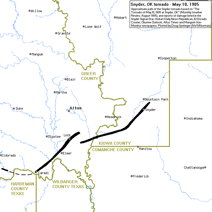 |
05/10/1905 | 2045 | 22# | 880 | F5 | 97* | 58* | Jackson/ Kiowa | 3 SSW Humphreys - Snyder - 3 NE Snyder |
|
This violent tornado developed about 2-3 miles southeast of the Frances school house (~3 miles south-southwest of Humphreys, OK) in old Greer County (now Jackson County). Homes were swept away about 14 miles southeast of Altus, OK. From its inception, this tornado moved east-northeast crossing the North Fork of the Red River near the mouth of Otter Creek. The tornado followed very close to Otter Creek curving to the northeast through what is now northern Tillman County (but was still part of Kiowa County at the time). Three people were killed about 6 miles southwest of Snyder, OK. As the tornado continued to the northeast it struck the city of Snyder around 8:45 pm CST. The tornado moved into the Snyder beginning in the southwest corner of the town, and destroyed or damaged homes and other buildings west of Main Street and from 6th Street northward through the city. No buildings north of the railroad were left standing. After moving through Snyder, the tornado continued northeastward, destroying a couple of small residences within two miles of the townsite, then lifted about three miles northeast of Snyder. * Current "official" numbers. # Path length is approximated and is based on research done by NWS Norman staff. |
|||||||||
| 04/18/1917 | 1855 | 30 | 50 | F3 | 1 | 15 | Jackson/ Tillman/ Kiowa | Near Altus to between Snyder and Manitou | |
|
A tornado destroyed a school 2 miles southwest of Snyder and then swept northeastward through the residence section on the southeast side of the city of Snyder. The path width was about 150 yards wide and about 75 buildings were either damaged or destroyed. No one was killed, but 15 persons were injured. Many horses and cattle were killed, and property losses totaled about $100,000. |
|||||||||
| 06/16/1928 | 1815 | 30 | 880 | F4 | 7 | 21 | Jackson/ Kiowa | Near Blair - near Headrick | |
|
The tornado moved southeast from about 5 miles northwest of Blair and passed directly through the town. Many homes were swept away on the southwest side of Blair, and the tornado killed three persons in the town. The tornado moved southeast and killed four people near Headrick before dissipating. Over 1,000 cattle were killed by the tornado and downburst winds produced by the parent supercell thunderstorm. |
|||||||||
| 06/05/1936 | 1730 | 6 | 75 | F3 | 1 | 1 | Kiowa | SW of Snyder | |
|
This tornado moved to the north and passed 4 miles west of Snyder. One person was killed and one person was injured. Several buildings were demolished, and 20 head of cattle and several horses were killed. |
|||||||||
| 04/28/1950 | 1417 | 21 | 400 | F3 | 1 | 1 | Kiowa/ Washita | Near Lugert (15 SW Hobart) - near Lone Wolf - near Sentinel | |
|
This strong tornado touched down in the vicinity of Altus-Lugert Lake about 15 miles southwest of Hobart, OK in Kiowa County, and progressed north-northeasterly to near Lone Wolf, OK. It then turned more northerly and dissipated near Sentinel, OK in Washita County. The tornado traveled along a 21-mile path. Five homes were demolished and another 6 were damaged. A total of 17 farms were damaged. One person was killed and another person injured. Property loss was estimated at $100,000. |
|||||||||
| 05/01/1954 | 1415 | (69) 34 |
(440) 267 |
F4 | 0 | (2) 0 |
(Foard TX/ Wilbarger TX/) Tillman/ Kiowa | (Crowell and Elliot areas TX) - E of Tipton - near Snyder | |
|
This tornado began near the town of Crowell in Foard County and moved northeastward through Wilbarger County in western north Texas, passing 4 miles to the northwest of Vernon. Five outbuildings were destroyed and 3 homes were demolished. In addition, two homes and an oil mill had lost their roofs. One automobile was picked up by the tornado and thrown a half mile in distance. Only light damage was reported to crops in Texas. The tornado continued moving northeastward and crossed the Red River into southwestern Oklahoma. Damage in western north Texas was estimated at $100,000. The tornado moved north-northeastward through southwestern Oklahoma from near Grandfield in southwestern Tillman County, and then into Kiowa County near Snyder. Considerable damage occurred to 20 homes and barns, 1 school, and 1 cotton gin. The tornado was observed by many people as it passed through the area, and was accompanied by hail to the size of golf balls. Damages in Kiowa County estimated at $5,000 from the tornado and $2,000 from hailstones. Damages from the tornado in Tillman County were estimated at $400,000, with only minor hail damage occurring in the county. |
|||||||||
| 04/02/1957 | 1830 | 44 | 150 | F2 | 0 | 1 | Jackson/ Kiowa | 2.5 E Altus - just W of Mountain View | |
|
This tornado touched 2.5 miles east of Altus and moved northeastward into Jackson County to near Roosevelt before lifting just west of Mountain View. The heaviest damage occurred about southwest and west of Friendship in Jackson County where numerous farms were damaged or destroyed. One injury resulted when the tornado demolished a truck. The parent supercell thunderstorm also produced a swath of damaging hail that covered a 4 miles by 6 mile area near Roosevelt, and resulted in estimated $5,000 in damages. |
|||||||||
| 04/29/1970 | 2225 | 171 | 250 | F2 | 0 | 2 | Jackson/ Kiowa/ Caddo/ Grady/ Canadian/ Oklahoma/ Logan/ Payne | Near Olustee - 5 S Stillwater [tornado family. Not continuous path] | |
|
A supercell thunderstorm developed in southwestern Oklahoma during the evening of April 29th, and went on to produce a series of tornadoes from near Olustee in Jackson County to 5 miles south of Stillwater in Payne County. This event was originally thought to have been produced by a single, long-track tornado, but data analysis done by scientists at the National Severe Storm Laboratory (NSSL) and information collected from storm surveys, eyewitnesses, and media accounts indicate that multiple tornadoes were produced by a cyclic, parent supercell thunderstorm that moved northeastward at 45 mph during its lifetime. A tornado was first reported near Olustee at approximately 10:25 pm CST on April 29th. Several sightings of tornadoes were reported along the path of the supercell, with a report of the dissipation of the last tornado occurring 5 miles south of Stillwater at 2:00 am CST on April 30th. The supercell thunderstorm was tracked on radar by the Nation Weather Service forecast office (then U.S. Weather Bureau) in Oklahoma City near the Will Rogers World Airport. The greatest damage along the storm path was in the extreme northwest section of Oklahoma City. There, 30 homes value at $35,000 to $ 50,000 each were either destroyed of damaged. At one point, southwest of Coyle in Logan County, a tornado picked up a mobile home and moved it 110-150 feet to the west of its original location while the storm continued on in a northeasterly direction. Two people were slightly injured in the mobile home. A pilot flew over the storm path from east of Guthrie in Logan County to south of Stillwater in Payne County, and reported seeing several intermittent damage paths within that flightline. |
|||||||||
| 02/22/1975 | 0100 | 5 | 75 | F2 | 1 | 2 | Kiowa | W of Snyder - Mountain Park | |
|
A tornado touched down just west of Snyder, OK and moved north-northeast into Mountain Park, OK. Power line poles were knocked down between Snyder and Mountain Park. Several homes in Mountain Park had their roofs damaged. A two-year-old boy was killed when the mobile home he was in was destroyed and two other people were injured. |
|||||||||
| 10/09/2001 | 1636-1710 | 13 | 440 | F3 | 0 | 1 | Kiowa/ Washita | 1 N Gotebo - 4.5 SSE Cowden (7 NNE Mountain View) | |
|
A major tornado outbreak occurred across western Oklahoma during the afternoon and early evening of October 9th. Nineteen tornadoes were confirmed, with three rated F3. This multiple-vortex tornado developed 1 mile north of Gotebo, resulting in mostly minor tree damage before crossing into Washita County at 4:49 pm CST. F1 damage was observed, however, 5 miles west of Mountain View, where a wood-frame barn was heavily damage. Extensive tree damage was observed from the Kiowa/Washita County border, northeastward to near OK State Highway 115, where the tornado leveled (rated F2) the Oakdale Schoolhouse, an old structure built in the 1920s. Across the street from the schoolhouse, a diesel shop was leveled, along with a barn, garage, and an unanchored wood-floor home. Several vehicles and large pieces of farm equipment were also tossed and destroyed. About 4 miles north-northeast of Mountain View, 3 homes suffered major damage, with one rated F3. As the tornado continued northeastward, F3 damage was inflicted on a farm, where a house and several barns and outbuildings were leveled. A 10,000-gallon diesel tank ended up in an open field about one-quarter mile away from its original position. |
|||||||||
| 05/16/2015 | 1626-1745 | 42 | 1600 | EF3 | 0 | 0 | Hardeman TX/ Wilbarger TX/ Jackson OK/ Wilbarger TX/Jackson OK/ Tillman OK/ Kiowa OK | 8 N Chillicothe TX - 3 E Snyder OK [EF0 in Texas] | |
|
With an upper low traversing the region, a cold front stationed over the Oklahoma and Texas panhandles, and a developing dryline, storms developed out in the panhandles early on May 16th and made their way eastward across western north Texas through the day. Toward evening, when the severe weather occurred, the front surged eastward with a line of storms forming along it. A storm chaser documented the beginning of a large and long-lived tornado in northeastern Hardeman County. No damage is known to have occurred in Hardeman County. The tornado moved into Wilbarger County and eventually into Oklahoma with a total path length of 40 miles. The tornado that began in northeast Hardeman County moved through the far northwestern corner of Wilbarger County before crossing the Red River into Jackson County, Oklahoma. No damage was known to have occurred in this rural area Wilbarger County. This tornado moved into Oklahoma from Wilbarger County Texas and continued to expand as it moved east-northeast across southern Jackson County. Despite the expansion of the tornado to an estimated 1000 yards wide, no significant damage is known to have occurred in this portion of Jackson County. The tornado crossed the Red River back into Wilbarger County before entering Jackson County again at 4:43 pm CST. The tornado crossed from Jackson County Oklahoma into far northern Wilbarger County between Odell TX and Elmer OK, before crossing the Red River for the third time back into Jackson County Oklahoma. Again, no damage is known to have occurred in this portion of Wilbarger County. The tornado moved back into Jackson County from Wilbarger County Texas and moved across the southeastern section of the county. Damage to trees, metal buildings and outbuildings were observed along U.S. Highway 283 to the southeast of Elmer. Damage to homes and trees continued to be observed as the tornado moved east-northeast. The most significant damage was observed 3 to 4 miles east of Elmer (DI 1, DOD 8; DI 2, DOD 6; DI 21, DOD 7; DI 27, DOD 5). The tornadic motion seen on videos and the radar presentation indicate that this likely was a violent tornado through southeast Jackson County, although only EF3 damage was observed as the tornado moved through this relatively sparsely populated area. KFDR radar measured 115 knot gate-to-gate rotational velocity when the tornado was east of Elmer. The tornado continued east-northeast moving into Tillman County about 4 miles west of Tipton. The tornado moved out of Jackson County and continued northeast passing into Kiowa County north of Manitou. EF2 damage continued to be observed north of Tipton, but again the tornado moved through sparsely populated farmland across northwestern Tillman County. The tornado width decreased from 1300 yards to 700 yards by the time it moved into Kiowa County. The tornado that originally began in northwest Hardeman County Texas moved into Kiowa County from Tillman County and finally ended its 40-mile path about 3 miles east of Snyder. Damage in Kiowa County was confined to broken power poles along U.S. Highway 183 south of Snyder and U.S. Highway 62 just southeast of Snyder and to trees. |
|||||||||
Records taken from the Storm Prediction Center archive data, "Storm Data", and data from the National Weather Service office in Norman. Data modified as described in NOAA Tech Memo NWS SR-209 (Speheger, D., 2001: "Corrections to the Historic Tornado Database").
Historic data, especially before 1950, are likely incomplete.


 Follow us on YouTube