
 |
November 2, 2017
Did you know that November 5 is World Tsunami Awareness Day? The purpose of this day is to educate people around the world about tsunamis. Tsunamis can be generated in all of the world’s oceans, inland seas, and in any large body of water. And they can strike any coast, at any time. This means that those of us who live, work or play on the coast should prepare for tsunamis.
So, in the spirit of the day, I thought I’d share some tips from my National Weather Service friends on how to prepare for a tsunami.
Want to learn more? Visit the National Weather Service’s Tsunami Safety website and test your knowledge with the Tsunami Crossword Puzzle.
|
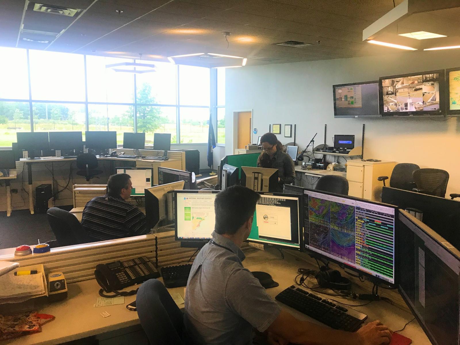
| Lead Forecasters Brian LaSorsa (far left), General Forecaster/Marine Program Lead Bryan Jackson (middle), and Meteorologist Intern Isha Renta (far right) in WFO Baltimore/Washington on July 12, 2017 |
August 31, 2017
Ever wonder how NWS forecasts are made? Are there computer robots constantly updating the forecast in your area? Well, there are actually many meteorologists working hard at 122 weather forecast offices (WFOs) across the U.S. and its territories!
Recently, I got to visit the NWS Weather Forecast Office Baltimore/Washington! Fun fact - though the office forecasts for Maryland and Washington, D.C., it is actually located in Sterling, Virginia and even forecasts for northern Virginia and eastern West Virginia!
Here’s another fun fact - Nearly 10 years ago, the office was physically moved about a mile away from its original location by Dulles Airport when airport officials decided to expand their runways. That now makes WFO Baltimore/Washington one of the newest office buildings in the Weather Service!
This office has a unique forecasting zone starting with the sparsely populated mountains of northern Virginia and eastern West Virginia. They forecast the populated low-lying Chesapeake Bay areas and the extremely populated metro D.C. area as well. These elevation and topographic changes present the forecaster with the challenging task of forecasting all weather types including tornadoes, hurricanes, snow, fire weather, and even water tide levels.
During my visit, I got a first hand look at the daily jobs of the different forecasters in the office. I learned that on a typical day without severe weather events, the WFO has three meteorologists on staff during the daytime hours. You can see them in the photo!
These forecasters make accurate weather predictions, because their information comes from useful sources including weather balloons! Twice everyday, they, and every other WFO launches weather balloons to get upper-air wind, temperature, and moisture data.
One forecaster monitors and posts to social media to keep the public up to date on local and national weather events. Another forecaster issues short-term forecasts (Day 1 - Day 3), Advisories, Watches, and Warnings, as well as writes outlooks and other statements for hazardous weather. The third forecaster focuses on long-term weather (Day 3 - Day 7).
Sometimes, offices work together! There are actually times before issuing warnings, watches and advisories that forecasters collaborate with their surrounding offices. That way, the offices forecast and issue consistent information. WFO Baltimore/Washington has six surrounding offices.
I also got to spend time with the Warning Coordination Meteorologist (WCM). Their job is to interact with the general public and to teach about weather science, safety, and preparedness during outreach events. Another job duty is to provide vital information to public officials and decision makers when hazardous weather strikes to keep you safe in your community. When the boss (who oversees the forecast office day-to-day operations) is absent, or when the lead forecaster is absent, the WCM acts in their place to make sure the job gets done.
I love visiting WFOs and talking with the forecasters! Learn what opportunities lie ahead for a career with NWS here. You can also find your local forecast office and explore their volunteer and shadowing opportunities!
 |
| Presenting the daily weather briefing in the NWS National Operations Center |
August 16, 2017
This summer, I took a trip to the NWS Operations Center (NWSOC) in Silver Spring, Maryland!
Days at the NWSOC are action packed! This important team keeps all of the NWS leadership informed with daily weather briefings, monitoring the weather for significant impacts, updating Weather.gov headlines with the current hazards, and writing a weather summary for each day.
During my visit, I got to participate in the operations briefing - check it out in the photo! The goal of the briefing is to receive and relay relevant and newsworthy information to all branches of NWS. These briefings feature updates from the National Water Center, Weather Prediction Center, Storm Prediction Center, National Hurricane Center, and Climate Prediction Center. They also give updates on the national instrumentation, recent impacts to the organization, and of course the current weather conditions.
I also learned about the four different levels of operation, which vary depending on the current impacts or hazards. On the day of my visit, the NWSOC had normal Level Four operations. They explained that Level One is the most extreme operation and is only in effect during catastrophic emergencies like the levee failure following Hurricane Katrina. Levels Two and Three are for extreme weather events like tropical storms and hurricanes, or specific threats and incidents impacting the operations of NWS as a whole, like a forecast office not being able to operate one day. The office operates 16 hours/day through two shifts during a Level Four day. Anytime something disrupts the normal work flow, NWSOC operates with more shifts between 16 and 20 hours/day for Level Three, and the complete 24 hours/day for Levels Two or One.
Wow! I know so much more about the NWSOC! Their mission is to gather and transmit weather service information internally to keep the agency running as smooth as possible. Just like me, they focus on the NWS mission of saving lives like yours and protecting property from hazardous weather!
 |
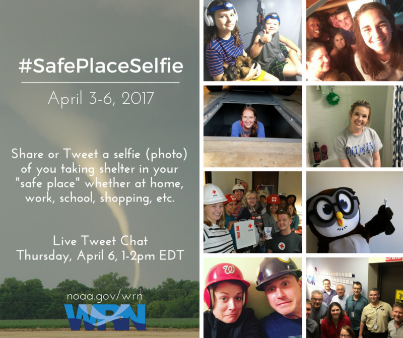
| A GOES-16 Red-Blue-Green forecasting product used by the International Desks |
August 7, 2017
Did you know that NWS has nine National Centers for Environmental Prediction, and five of them are housed under the same roof? Conveniently, Climate Prediction Center, Environmental Modeling Center, Ocean Prediction Center, NCEP Central Operations, and Weather Prediction Center are located at NOAA Center for Weather and Climate Prediction (NCWCP) in College Park, Maryland.
I went to visit the Weather Prediction Center (WPC) specifically. During my trip, I learned some fascinating information about what they do every day! On a given day, WPC is fully staffed with 33 meteorologists!
WPC produces short (days 1 - 2) and medium-range (days 3 - 7) forecasts. Unlike weather forecast offices that examine every county in the U.S., WPC forecasts rain and snowfall amounts for the entire country, write storm summaries every six hours for large precipitation events, and issue tropical advisories when tropical storms make landfall. The Short-Range Desk also creates surface analyses every six hours highlighting fronts, high and low pressure systems, temperatures, dew point temperatures, sea-level pressure, wind speed and direction. If you’re like me, you find learning about weather science fun! There is a Short Range Public Discussion published to explain the current surface analysis so that you can better understand the upcoming U.S. weather patterns over the next two days. That’s not all! There is also a Winter Weather Desk specifically dedicated to forecasting temperatures, wind chill, and analyzing snowfall from mid September through the cold season.
The national forecast process covers almost every part of North America with the exception of Mexico. Fortunately, Mexico isn’t completely forgotten as the WPC collaborated with the World Meteorological Organization to create the International forecasting Desks to cover Mexico through the South America. Since 1988, Latin American forecasters have been trained to forecast weather for Mexico, Central America, and northern South America by the Tropical Desk. Then since 1992, the rest of South America has been covered by Latin American forecasters at the South American Desk. You can see one of their satellite imagery forecasting products in the picture below!
With all of these functions, WPC stays very busy even on days without hazardous weather. From local forecast offices to national centers, the scientists of NWS are working around the clock to ensure your safety and keep everyone informed of the upcoming weather!
 |
July 31, 2017
What a blast it was sharing so many different resources with you! Now’s the time to start creating lesson plans with the different internal NWS Education resources, NOAA resources, and some of our outstanding partner resources. You can even share what you’ve learned with friends.
If you missed a day or just want to further explore any specific resources, you’re in luck! I made a consolidated list of resources which will be available throughout the school year. Feel free to get started today on developing lesson plans using fun ideas, information, learning resources, and classroom ideas for a WEATHERful school year!
|
June 27, 2017
Do you like learning about the weather? I know I do! I have found so many useful online resources from NOAA, the National Weather Service, and their partners highlighting a plethora of weather information. Many of these resources were designed for educators and parents to teach to students in schools, community centers, after school and other programs. Now that I’ve explored them all, I’m just so excited to share everything with you!
The 2017 Back to School Campaign will run from July 16 - 30! It will feature over 30 weather-related resources to help educators and others who support education prepare for the upcoming school year! We will share learning resources like lesson plans, classroom ideas like experiments and activities, and weather safety and preparedness information. Follow me on Facebook and Twitter to see the posts everyday!
Don’t worry, there is still lots of summer left, but your teachers are always working hard planning for the upcoming school year! Have fun checking out some of the fun ideas, information, learning resources, and classroom ideas you might see when you head back to school. Also, if you happen to miss a day, following the campaign, we will provide a consolidated list of the education resources for students of all ages! I’m ready for Back to School!
 |
May 4, 2017
We’ve all experienced thunderstorms and lightning. When lightning flashes and strikes the ground, it can be both an amazing and scary experience. But have you wondered how lightning forms?
Scientists have wondered this as well. The primary theories involve something called “charge separation” (we’ll get to that shortly), which leads to the generation of an electric field within a thunderstorm. In addition, recent studies suggest that the production of ice, hail, and semi-frozen water drops in a thunderstorm are essential to the creation of lightning.
First, you cannot have lightning without electricity! All matter in the universe is made up of particles, and these particles all contain an electric charge, which can either be positive, negative, or neutral. The most common building block of matter is the atom, which is made up of particles called protons, neutrons, and electrons. Protons have a positive charge, neutrons a neutral charge, and electrons a negative charge. Normally, atoms contain the same number of protons and electrons, which results in a neutral charge.
Now that we have a basic understanding of electric charges, let’s talk about how thunderstorms result in charge separation. The inside of a thunderstorm is a very turbulent environment, with strong updraft and downdraft winds regularly occurring very close to each other. Because of this, ice, hail, and semi-frozen water drops get tossed around all over the inside of the thunderstorm. As a result the top of the thunderstorm ends up containing an overall positive charge, while the thunderstorm’s bottom becomes negatively charged. This is charge separation.
Because electricity generates between positive and negative charges, the charge separation causes an electrical field to be generated inside of the thunderstorm. This electrical field creates lightning within the thunderstorm, but it’s not yet enough to cause lightning to strike the ground.
When it comes to electrical charges, opposites attract. Therefore, the massive buildup in negative charge near the base of the thunderstorm can eventually create a lot of positive charge on the ground below it. The buildup of positive charge on the ground can then interact with the buildup of negative charge at the base of the thunderstorm, and the eventual interaction between those positive and negative charges is what we see as lightning.
That’s what we generally know about how lightning is formed. So now the next time you see a lightning strike, you’ll also know the science behind it. But don’t forget that lightning is very dangerous as well. If there’s a thunderstorm happening outside, you should be inside. Remember - When Thunder Roars, Go Indoors!
 |
March 30, 2017
Do you know what to do in a dangerous weather event? No matter the type of weather you’re facing, the most important thing to do is get to a safe place! Knowing your "safe place" when extreme weather threatens is the #1 preparedness action anyone can take.
To encourage the use of safe places by everyone, the National Weather Service will be launching a social media campaign called “Safe Place Selfie”, which will take place April 3-6, 2017. What can you do to participate? It’s simple! Just take a selfie of you in your safe place, and post it on social media with the hashtag #safeplaceselfie.
Whether you’re at home, at school, at work, or out around town, it’s important to know where your safe place is in case dangerous weather strikes. A common safe place would be a basement. A car can also be a safe place in the event of certain kinds of dangerous weather, such as lightning (however, a car is not a safe place in the event of floods).
Focus is broad across the spectrum of hazards, and not just tornadoes. Hazards to consider: lightning, severe (tornadoes, high winds), extreme heat/cold, flooding, rip currents, wildfires, hurricanes, tsunamis. Get creative! Is there a beach nearby or are locals planning vacations to warmer climates? Help spread rip current awareness by focusing on where your safe place would be (hint: between the lifeguard flags).
Find your safe place, take a selfie, and share it with the world to let everyone know that you’re Weather-Ready. Also, be sure to encourage others to share their Safe Places Selfies too! Together, we can all be part of a Weather-Ready Nation!

