
Severe thunderstorms, excessive rainfall, critical fire weather are all in the outlook today and into this last weekend of April. Very large hail, severe wind gusts, and a couple strong tornadoes will all be possible across the central and southern Plains today. Flash flooding also possible for portions of the Plains and Mississippi Valley. Critical fire weather conditions for Southern High Plains Read More >
Overview
|
A warm and very humid air mass was in place over the mid-Atlantic on July 17. A warm front which had sagged south into the region on the night of the 16th pushed back to the north on the morning of the 17th. Meanwhile, a cold front slowly approached by evening, with a pre-frontal surface trough ahead of it. The presence of multiple synoptic and mesoscale boundaries led to a highly complex convective evolution. Several areas and multiple rounds of convection affected the eastern mid-Atlantic over about a 12 hour period from early afternoon on the 17th to a little after midnight on the 18th. With wind shear falling in the weak to moderate range, convection mainly took the form of multi-cellular and linear clusters, though some semi-discrete supercellular structures were noted at times. A number of storms became severe with damaging wind. A weak tornado was confirmed in Burlington County, NJ in association with a line of thunderstorms in the later evening. This was likely aided by a remnant outflow boundary from earlier storms. Areas of heavy rain and flash flooding also occurred due to the widespread and at times slow moving nature of the convection. Flash flooding was especially severe in and around Hunterdon County, NJ. Eventually, by later in the night, the approach of the cold front and significant overturning of the atmosphere from the day's convection caused remaining activity to weaken and shift offshore. |
 KDIX radar loop from 10:20PM to 10:36PM on July 17, 2021, featuring the Burlington County, NJ EF-1 tornado. |
Synoptic Overview at 12z 17 Jul 2021 (courtesy of SPC)
 |
 |
 |
| Figure 1: 250-mb analysis | Figure 2: 300-mb analysis | Figure 3: 500-mb analysis |
 |
 |
 |
| Figure 4: 700-mb analysis | Figure 5: 850-mb analysis | Figure 6: 925-mb analysis |
Synoptic Overview at 00z 18 Jul 2021 (courtesy of SPC)
 |
 |
 |
| Figure 7: 250-mb analysis | Figure 8: 300-mb analysis | Figure 9: 500-mb analysis |
 |
 |
 |
| Figure 10: 700-mb analysis | Figure 11: 850-mb analysis | Figure 12: 925-mb analysis |
Surface Maps (courtesy of WPC)
 |
 |
 |
| Figure 13: 12z surface map | Figure 14: 15z surface map | Figure 15: 18z surface map |
 |
 |
 |
| Figure 16: 21z surface map | Figure 17: 00z surface map | Figure 18: 03z surface map |
 |
 |
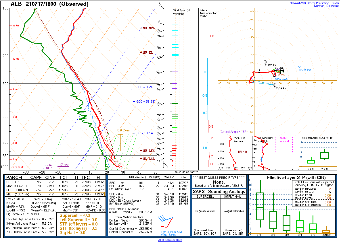 |
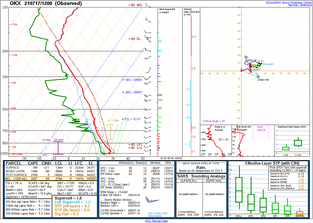
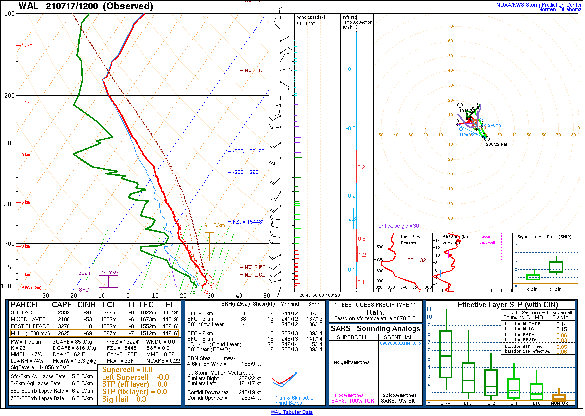
| Figure 19: 12z Long Island, NY sounding | Figure 20: 12z Wallops Island, VA sounding | Figure 21: 18z Albany, NY special sounding |
 |
 |
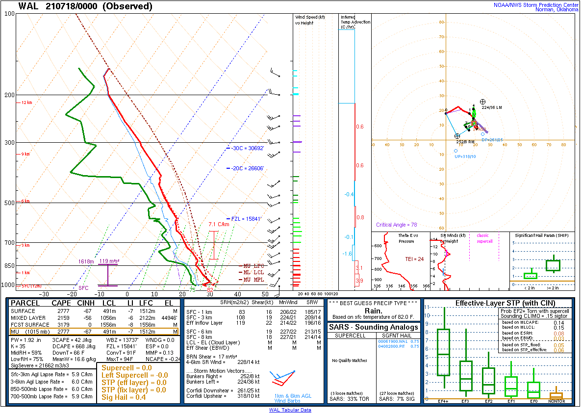 |
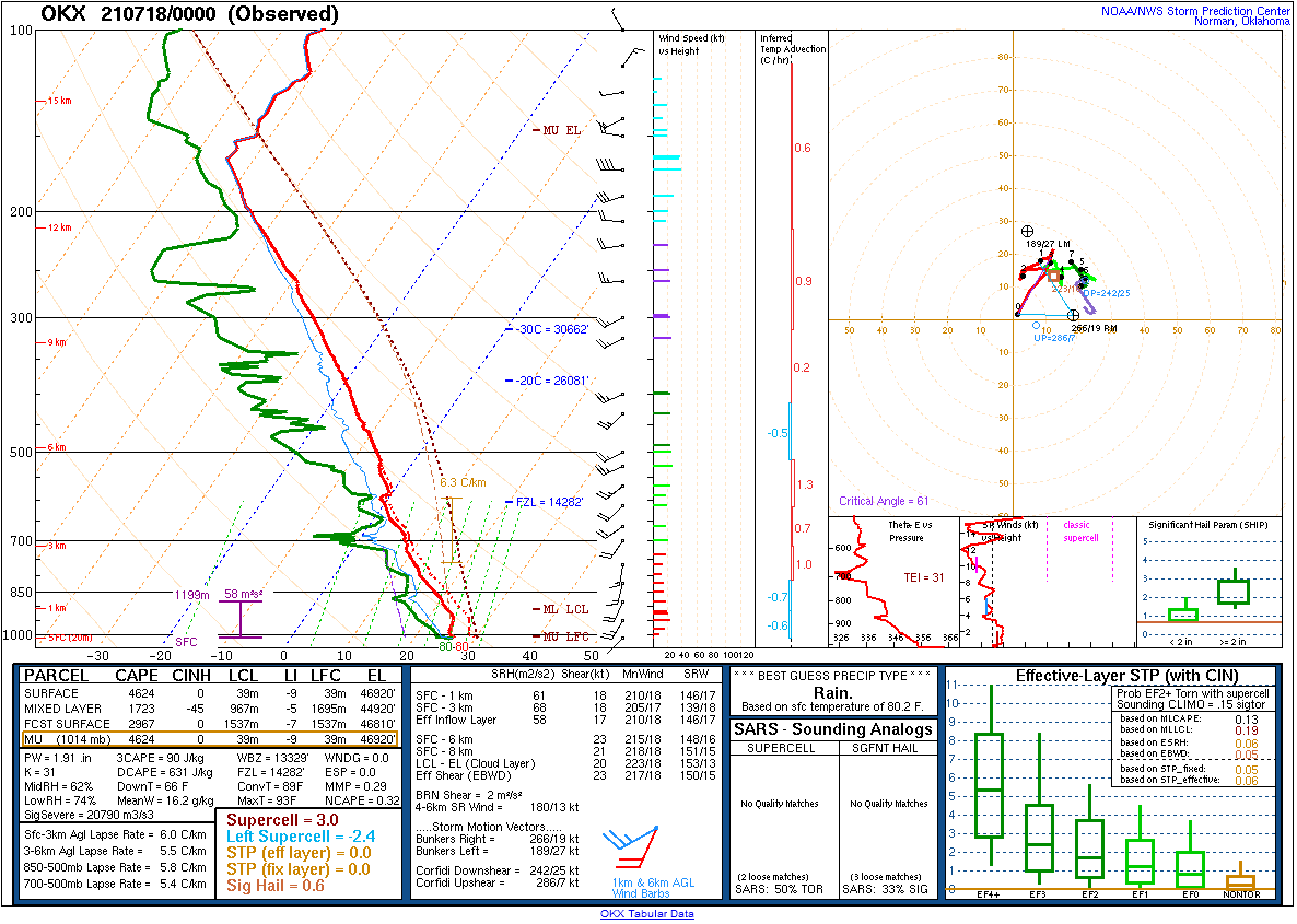
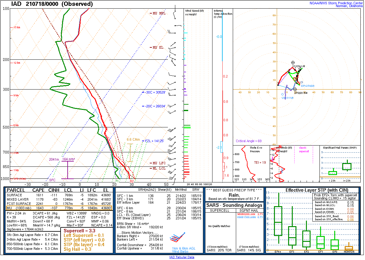
| Figure 22: 00z Long Island, NY sounding | Figure 23: 00z Sterling, VA sounding | Figure 24: 00z Wallops Island, VA sounding |
 |
 |
 |
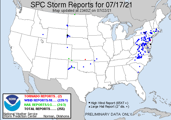
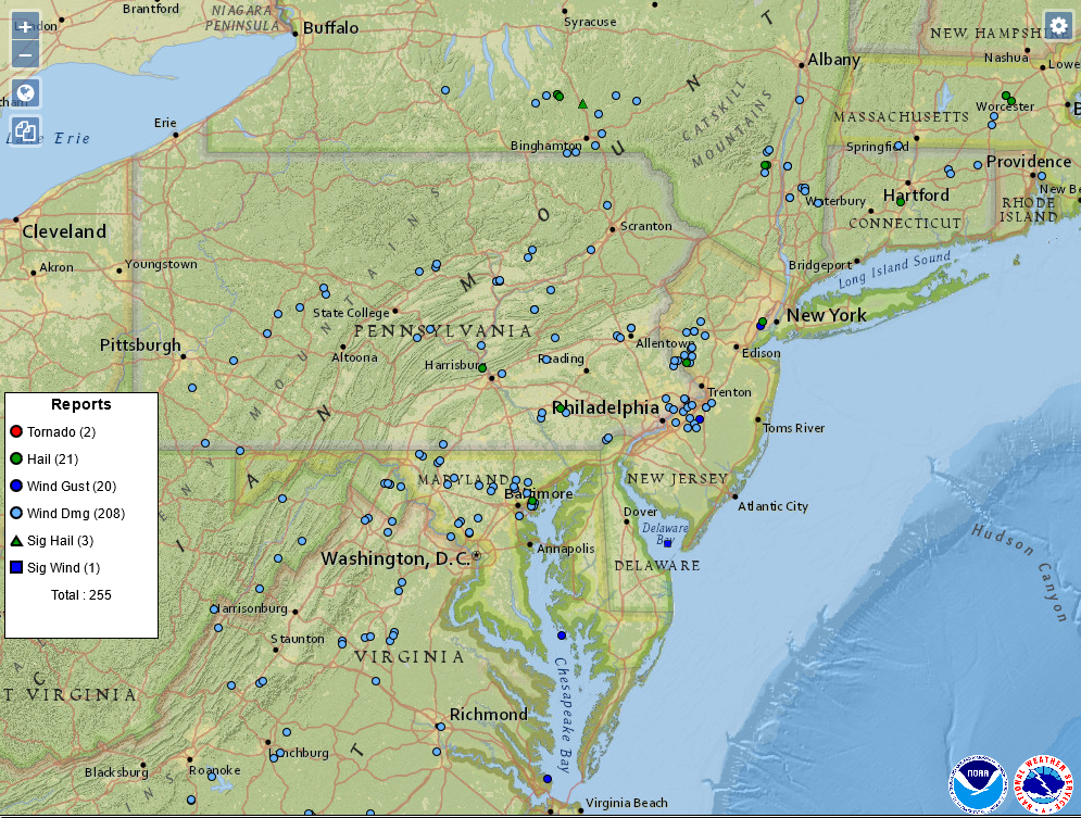
| Figure 1: National Preliminary Reports 12z 17 Jul 2021 to 12z 18 Jul 2021 | Figure 2: Zoomed Preliminary Reports for the same period. | Figure 3: Prelim Reports vs. 1630z SPC Convective Outlook |
Click here for a county warning area based plot of local storm reports and warnings/advisories issued for the 17 Jul 2021 event.
NWUS51 KPHI 182100
LSRPHI
PRELIMINARY LOCAL STORM REPORT...SUMMARY
NATIONAL WEATHER SERVICE MOUNT HOLLY NJ
500 PM EDT SUN JUL 18 2021
..TIME... ...EVENT... ...CITY LOCATION... ...LAT.LON...
..DATE... ....MAG.... ..COUNTY LOCATION..ST.. ...SOURCE....
..REMARKS..
1245 PM HAIL 1 SSE DOYLESTOWN AIRPOR 40.33N 75.12W
07/17/2021 E0.25 INCH BUCKS PA TRAINED SPOTTER
0108 PM TSTM WND DMG 3 E GARDENVILLE 40.37N 75.05W
07/17/2021 BUCKS PA TRAINED SPOTTER
SEVERAL LARGE TREES AND NUMEROUS BRANCHES
DOWN WITH POWER OUTAGES.
0115 PM TSTM WND DMG SERGEANTSVILLE 40.45N 74.94W
07/17/2021 HUNTERDON NJ 911 CALL CENTER
REPORTS OF TREES DOWN AROUND DELAWARE
TOWNSHIP. TIME ESTIMATED FROM RADAR.
0115 PM TSTM WND DMG 2 W STOCKTON 40.41N 75.01W
07/17/2021 HUNTERDON NJ DEPT OF HIGHWAYS
TREE DOWN ON NJ ROUTE 29, ALL LANES AND
RIGHT SHOULDER CLOSED.
0135 PM TSTM WND DMG RARITAN TWP 40.50N 74.87W
07/17/2021 HUNTERDON NJ 911 CALL CENTER
REPORTS OF TREES DOWN AROUND RARITAN
TOWNSHIP.
0200 PM TSTM WND DMG LEBANON 40.64N 74.84W
07/17/2021 HUNTERDON NJ 911 CALL CENTER
REPORTS OF TREES DOWN IN LEBANON AND CLINTON
TOWNSHIPS. TIME ESTIMATED FROM RADAR.
0215 PM TSTM WND DMG TEWKSBURY TWP 40.71N 74.77W
07/17/2021 HUNTERDON NJ 911 CALL CENTER
REPORTS OF TREES DOWN IN TEWKSBURY TOWNSHIP.
TIME ESTIMATED FROM RADAR.
0215 PM HAIL 1 S GLEN GARDNER 40.69N 74.94W
07/17/2021 U0.50 INCH HUNTERDON NJ PUBLIC
REPORT FROM MPING: HALF-INCH (0.50 IN.).
0227 PM FLOOD 1 NW LAKE COMO 40.18N 74.03W
07/17/2021 MONMOUTH NJ DEPT OF HIGHWAYS
FLOODING REPORTED ON NJ 71. ONE LANE CLOSED
IN EACH DIRECTION.
0300 PM TSTM WND GST NORTH CATASAUQUA 40.66N 75.48W
07/17/2021 M58 MPH NORTHAMPTON PA TRAINED SPOTTER
MEASURED WIND GUST FROM THE EAST FROM A
MICROBURST. A SECOND GUST OF 57 MPH OCCURRED
FROM THE WEST A SHORT TIME LATER. TREES AND
TREE BRANCHES SNAPPED NEARBY.
0307 PM FUNNEL CLOUD WOODBRIDGE 40.56N 74.28W
07/17/2021 MIDDLESEX NJ TRAINED SPOTTER
SPOTTER REPORTED A FUNNEL CLOUD AT 3:07 PM.
FROM HIS VANTAGE POINT, IT DID NOT APPEAR TO
MAKE CONTACT WITH THE GROUND.
0310 PM TSTM WND DMG 2 N UPPER MACUNGIE TWP. 40.60N 75.62W
07/17/2021 LEHIGH PA PUBLIC
LARGE TREE SNAPPED. TIME ESTIMATED FROM
RADAR.
0310 PM TSTM WND DMG 2 NE UPPER MACUNGIE TWP 40.59N 75.59W
07/17/2021 LEHIGH PA PUBLIC
SOME SIDING BLOWN OFF A HOME. TIME ESTIMATED
FROM RADAR.
0331 PM HAIL HOPELAWN 40.53N 74.29W
07/17/2021 E0.88 INCH MIDDLESEX NJ TRAINED SPOTTER
0337 PM TSTM WND GST HOPELAWN 40.53N 74.29W
07/17/2021 M54 MPH MIDDLESEX NJ TRAINED SPOTTER
0400 PM HEAVY RAIN HOPELAWN 40.53N 74.29W
07/17/2021 M2.38 INCH MIDDLESEX NJ TRAINED SPOTTER
FELL WITHIN 1 HOUR...BETWEEN 3 PM AND 4 PM.
0500 PM HAIL FLEMINGTON 40.51N 74.86W
07/17/2021 E0.25 INCH HUNTERDON NJ PUBLIC
0510 PM TSTM WND DMG FLEMINGTON 40.51N 74.86W
07/17/2021 HUNTERDON NJ TRAINED SPOTTER
TREE AND WIRES DOWN ACROSS A ROAD IN
FLEMINGTON. TIME ESTIMATED FROM RADAR.
0530 PM TSTM WND DMG 2 ESE WHITEHOUSE STATIO 40.60N 74.73W
07/17/2021 HUNTERDON NJ 911 CALL CENTER
TREE DOWN COMPLETELY BLOCKING THE ROAD. TIME
ESTIMATED FROM RADAR.
0615 PM TSTM WND DMG LEBANON 40.64N 74.84W
07/17/2021 HUNTERDON NJ PUBLIC
TREE AND WIRES DOWN. TIME ESTIMATED FROM
RADAR.
0630 PM TSTM WND GST CHALFONT 40.29N 75.21W
07/17/2021 E50 MPH BUCKS PA TRAINED SPOTTER
ALONG WITH HEAVY RAIN.
0635 PM FLASH FLOOD 3 NE RINGOES 40.47N 74.83W
07/17/2021 HUNTERDON NJ OTHER FEDERAL
FLOODING ALONG THE NESHANIC RIVER AT
REAVILLE BASED ON THE RIVER GAUGE.
0643 PM HAIL 2 NE LAMBERTVILLE 40.39N 74.92W
07/17/2021 E1.00 INCH HUNTERDON NJ TRAINED SPOTTER
0655 PM TSTM WND DMG LAWNDALE 40.05N 75.09W
07/17/2021 PHILADELPHIA PA UTILITY COMPANY
SEVERAL POWER OUTAGES REPORTED IN NORTHEAST
PHILADELPHIA. TIME ESTIMATED FROM RADAR.
0700 PM FLASH FLOOD FLEMINGTON 40.51N 74.86W
07/17/2021 HUNTERDON NJ TRAINED SPOTTER
REPORTS OF SEVERAL ROADS FLOODED. TIME
ESTIMATED.
0700 PM TSTM WND DMG ABINGTON 40.12N 75.13W
07/17/2021 MONTGOMERY PA PUBLIC
SEVERAL TREES DOWN AND POWER OUTAGES. TIME
ESTIMATED FROM RADAR.
0705 PM TSTM WND GST RINGOES 40.44N 74.85W
07/17/2021 E50 MPH HUNTERDON NJ TRAINED SPOTTER
ALONG WITH DIME SIZE HAIL. TIME ESTIMATED
FROM RADAR.
0705 PM TSTM WND DMG LUMBERVILLE 40.41N 75.04W
07/17/2021 BUCKS PA PUBLIC
SEVERAL TREES BLOWN DOWN NEAR THE
INTERSECTION OF FLEECY DALE ROAD AND RIVER
ROAD.
0710 PM FLASH FLOOD 3 SW QUAKERTOWN 40.53N 74.97W
07/17/2021 HUNTERDON NJ PUBLIC
WATER RESCUE IN THE AREA OF OAK GROVE AND
LOWER OAK GROVE IN FRANKLIN TOWNSHIP.
0710 PM FLASH FLOOD 2 ESE STANTON 40.56N 74.80W
07/17/2021 HUNTERDON NJ PUBLIC
WATER RESCUE ON PLEASANT RUN ROAD.
0715 PM FLASH FLOOD 2 WSW MANVILLE 40.53N 74.62W
07/17/2021 SOMERSET NJ 911 CALL CENTER
US ROUTE 206 IS IMPASSABLE AT CAMPLAIN ROAD
IN HILLSBOROUGH TOWNSHIP DUE TO FLOODING.
0720 PM TSTM WND DMG 3 ENE LAMBERTVILLE 40.39N 74.89W
07/17/2021 HUNTERDON NJ TRAINED SPOTTER
FEW TREES SNAPPED. TIME ESTIMATED FROM
RADAR.
0730 PM HEAVY RAIN 3 E FRENCHTOWN 40.53N 75.01W
07/17/2021 M3.75 INCH HUNTERDON NJ MESONET
KINGWOOD TOWNSHIP - NEW JERSEY WEATHER
NETWORK.
0730 PM TSTM WND DMG RINGOES 40.44N 74.86W
07/17/2021 HUNTERDON NJ PUBLIC
REPORT OF A TREE BLOWN DOWN INTO A HOUSE.
TIME ESTIMATED FROM RADAR.
0735 PM TSTM WND DMG 1 WSW CLINTON 40.63N 74.92W
07/17/2021 HUNTERDON NJ DEPT OF HIGHWAYS
TREE DOWN ON INTERSTATE 78. TIME ESTIMATED
FROM RADAR.
0805 PM FLOOD 1 SSW WASHINGTON CROSSI 40.28N 74.88W
07/17/2021 BUCKS PA PUBLIC
REPORT FROM MPING: RIVER/CREEK OVERFLOWING;
CROPLAND/YARD/BASEMENT FLOODING.
0808 PM TSTM WND DMG BENSALEM 40.11N 74.93W
07/17/2021 BUCKS PA TRAINED SPOTTER
SEVERAL POWER OUTAGES. LARGE BRANCHES BLOWN
DOWN AND SIDING BLOWN OFF A HOUSE. SPOTTER
ESTIMATED WINDS ABOVE 60 MPH. TIME ESTIMATED
FROM RADAR.
0815 PM TSTM WND DMG 1 NW BENSALEM 40.12N 74.94W
07/17/2021 BUCKS PA TRAINED SPOTTER
TREE DOWN.
0825 PM TSTM WND DMG MEDFORD 39.89N 74.82W
07/17/2021 BURLINGTON NJ PUBLIC
SEVERAL TREES BLOWN DOWN. TIME ESTIMATED
FROM RADAR.
0830 PM FLASH FLOOD EWING 40.27N 74.80W
07/17/2021 MERCER NJ 911 CALL CENTER
WIDESPREAD ROADWAY FLOODING WITH SOME ROADS
BECOMING IMPASSABLE.
0835 PM TSTM WND GST LAWRENCEVILLE 40.30N 74.73W
07/17/2021 M54 MPH MERCER NJ TRAINED SPOTTER
0850 PM FLASH FLOOD 1 ESE RARITAN TWP 40.50N 74.86W
07/17/2021 HUNTERDON NJ DEPT OF HIGHWAYS
FLOODING ON 202 SOUTHBOUND. ALL LANES
CLOSED. TIME ESTIMATED.
0855 PM TSTM WND GST 1 ESE LUMBERTON TWP 39.96N 74.79W
07/17/2021 M58 MPH BURLINGTON NJ MESONET
CWOP STATION EW8027 MEASURED GUST.
0900 PM FLASH FLOOD 3 NW SAND BROOK 40.50N 74.95W
07/17/2021 HUNTERDON NJ TRAINED SPOTTER
A FEW FEET OF WATER FLOODING WHISKEY LANE.
TIME ESTIMATED FROM RADAR.
0900 PM TSTM WND GST 1 E LUMBERTON TWP 39.96N 74.80W
07/17/2021 M53 MPH BURLINGTON NJ PUBLIC
WUNDERGROUND GAUGE KNJLUMBE10 MEASURED GUST.
A DAVIS STATION.
0915 PM FLASH FLOOD HOPEWELL 40.39N 74.75W
07/17/2021 MERCER NJ 911 CALL CENTER
WIDESPREAD ROADWAY FLOODING WITH SOME ROADS
BECOMING IMPASSABLE.
0920 PM HEAVY RAIN FLEMINGTON 40.51N 74.86W
07/17/2021 M5.41 INCH HUNTERDON NJ TRAINED SPOTTER
UPDATED TOTAL THROUGH 9 PM.
0929 PM TSTM WND DMG 2 ENE LANDENBERG 39.80N 75.73W
07/17/2021 CHESTER PA FIRE DEPT/RESCUE
TREE LIMBS BLOCKING THE ROAD ON KAOLIN RD AT
LIMESTONE RD. TIME ESTIMATED FROM RADAR AND
DISPATCH REPORT.
0930 PM MARINE TSTM WIND 9 WNW CAPE MAY POINT 38.99N 75.11W
07/17/2021 M78 MPH ANZ431 NJ OTHER FEDERAL
BRND1.
0932 PM TSTM WND DMG 2 S KENNETT SQUARE 39.81N 75.71W
07/17/2021 CHESTER PA FIRE DEPT/RESCUE
TREE DOWN BLOCKING THE ROAD ON ROUND HILL RD
AT KAOLI RD. TIME ESTIMATED FROM RADAR AND
DISPATCH REPORT.
1000 PM FLOOD GLOUCESTER CITY 39.89N 75.12W
07/17/2021 CAMDEN NJ TRAINED SPOTTER
REPORT OF STREET FLOODING IN THE AREA OF
BROADWAY AND MARKET. TIME ESTIMATED.
1002 PM TSTM WND DMG CHERRY HILL TWP 39.93N 75.03W
07/17/2021 CAMDEN NJ PUBLIC
SOME TREES BLOWN DOWN IN A CHERRY HILL
NEIGHBORHOOD.
1003 PM HAIL 1 S VILLAS 39.02N 74.94W
07/17/2021 U0.50 INCH CAPE MAY NJ PUBLIC
REPORT FROM MPING: HALF-INCH (0.50 IN.).
1005 PM TSTM WND DMG TACONY 40.03N 75.05W
07/17/2021 PHILADELPHIA PA PUBLIC
REPORT FROM MPING: TREES UPROOTED OR
SNAPPED; TIME ESTIMATED FROM RADAR.
1010 PM TSTM WND DMG DELRAN 40.02N 74.95W
07/17/2021 BURLINGTON NJ PUBLIC
SEVERAL LARGE LIMBS BLOWN DOWN. TIME
ESTIMATED FROM RADAR.
1014 PM TSTM WND DMG EDGEWATER PARK 40.05N 74.91W
07/17/2021 BURLINGTON NJ PUBLIC
NUMEROUS LIMBS DOWN AND POWER OUTAGE IN
EDGEWATER PARK. TIME ESTIMATED FROM RADAR.
REPORT RELAYED FROM NWS EMPLOYEE.
1016 PM FLOOD 1 NW EDDINGTON 40.10N 74.96W
07/17/2021 PHILADELPHIA PA PUBLIC
REPORT FROM MPING: STREET/ROAD FLOODING;
STREET/ROAD CLOSED; VEHICLES STRANDED.
1020 PM TSTM WND DMG 3 N MOUNT LAUREL 39.97N 74.89W
07/17/2021 BURLINGTON NJ PUBLIC
REPORT FROM MPING: TREES UPROOTED OR
SNAPPED; TIME ESTIMATED FROM RADAR.
1020 PM TSTM WND DMG BURLINGTON 40.07N 74.86W
07/17/2021 BURLINGTON NJ PUBLIC
SEVERAL LARGE TREE LIMBS BLOWN DOWN IN
BURLINGTON.
1025 PM FLASH FLOOD 1 NNW HOLMESBURG 40.05N 75.03W
07/17/2021 PHILADELPHIA PA OTHER FEDERAL
FLOODING ALONG THE PENNYPACK CREEK BASED ON
THE RIVER GAUGE.
1025 PM TORNADO 2 NW JOBSTOWN 40.05N 74.72W
07/17/2021 BURLINGTON NJ NWS STORM SURVEY
NWS STORM SURVEY CONFIRMED A TORNADO BEGAN
AT 10:25 PM EDT JUST EAST OF THE ROUTE 206
AND COLUMBUS-JOBSTOWN ROAD INTERSECTION. A
NARROW, DISCONTINUOUS, PATH OF TREE DAMAGE
CONTINUED FOR 7.9 MILES, ENDING NEAR
JACOBSTOWN, NJ. THE TORNADO DISSIPATED
AROUND 10:36 PM EDT. ESTIMATED PEAK WIND WAS
80 TO 90 MPH.
1027 PM TSTM WND DMG EVESHAM TWP 39.89N 74.91W
07/17/2021 BURLINGTON NJ 911 CALL CENTER
SEVERAL TREES WERE DOWNED IN EVESHAM TWP.
TIME ESTIMATED FROM RADAR.
1030 PM FLASH FLOOD 2 NE RINGOES 40.47N 74.83W
07/17/2021 HUNTERDON NJ PUBLIC
3 VEHICLES STRANDED IN FLOOD WATERS ON OLD
YORK ROAD AT THE NESHANIC RIVER. TIME
ESTIMATED.
1030 PM FLASH FLOOD 1 SSW SUMMERDALE 40.02N 75.10W
07/17/2021 PHILADELPHIA PA OTHER FEDERAL
FLOODING ALONG THE FRANKFORD CREEK BASED ON
THE RIVER GAUGE.
1032 PM TSTM WND DMG 3 SSW CHESTERFIELD 40.08N 74.66W
07/17/2021 BURLINGTON NJ TRAINED SPOTTER
LARGE TREE SNAPPED AND SEVERAL LARGE LIMBS
DOWN. TIME ESTIMATED FROM RADAR.
1040 PM MARINE TSTM WIND 20 E FENWICK ISLAND 38.45N 74.68W
07/17/2021 M40 MPH ANZ475 DE OTHER FEDERAL
1045 PM FLASH FLOOD 1 SW NESHANIC STATION 40.49N 74.76W
07/17/2021 SOMERSET NJ PUBLIC
WATER RESCUE REPORTED AT AMWELL ROAD AND
BLACKPOINT ROAD. TIME ESTIMATED.
1050 PM FLOOD 1 ESE ROXBOROUGH 39.99N 75.20W
07/17/2021 PHILADELPHIA PA PUBLIC
REPORT OF FLOODING ON I-76 WESTBOUND BETWEEN
CITY AVE AND MONTGOMERY DR.
1100 PM FLASH FLOOD 1 ESE JACKSONVILLE 40.04N 74.74W
07/17/2021 BURLINGTON NJ NWS EMPLOYEE
WARNER ROAD JUST WEST OF THE FAIRGROUNDS WAS
FLOODED AND IMPASSABLE. THE ROAD REMAINED
CLOSED THE NEXT DAY. TIME ESTIMATED FROM
RADAR.
1100 PM FLASH FLOOD BENSALEM 40.11N 74.94W
07/17/2021 BUCKS PA TRAINED SPOTTER
REPORT OF A WATER RESCUE IN BENSALEM.
SPOTTER ALSO REPORTED OVER 3 INCHES OF RAIN.
TIME ESTIMATED.
1100 PM FLASH FLOOD 1 E BRANCHBURG TWP 40.56N 74.68W
07/17/2021 SOMERSET NJ OTHER FEDERAL
FLOODING ON THE NORTH BRANCH OF THE RARITAN
RIVER AT SOUTH BRANCH BASED ON THE RIVER
GAUGE.
1115 PM FLOOD LEVITTOWN 40.16N 74.89W
07/17/2021 BUCKS PA TRAINED SPOTTER
TRENTON ROAD IN LEVITTOWN IS FLOODED AND
ALMOST IMPASSABLE. TIME ESTIMATED.
1130 PM MARINE TSTM WIND 1 SW SEASIDE PARK 39.93N 74.08W
07/17/2021 M39 MPH ANZ451 NJ PUBLIC
PERSONAL WEATHER STATION KNJSEASI6.
1135 PM MARINE TSTM WIND 1 WNW FORTESCUE 39.24N 75.18W
07/17/2021 M40 MPH ANZ430 NJ MESONET
NJ WEATHERNET SITE NJ67.
1135 PM MARINE TSTM WIND 1 W FORTESCUE 39.24N 75.18W
07/17/2021 M40 MPH ANZ430 NJ MESONET
NJ WEATHERNET SITE NJ67.
1145 PM FLOOD WHITMAN PARK 39.93N 75.11W
07/17/2021 CAMDEN NJ DEPT OF HIGHWAYS
FLOODING ON I-676 RAMP NORTHBOUND AT
ATLANTIC AVE. ALL LANES CLOSED. TIME
ESTIMATED.
0300 AM FLOOD 1 NNW HAMILTON TWP 40.25N 74.73W
07/18/2021 MERCER NJ OTHER FEDERAL
THE MERCERVILLE USGS GAUGE ROSE ABOVE FLOOD
STAGE ON THE ASSUNPINK CREEK AT 3:00 AM.
0400 AM FLOOD 1 NE TRENTON 40.22N 74.75W
07/18/2021 MERCER NJ OTHER FEDERAL
USGS GAUGE IN TRENTON ON THE ASSUNPINK CREEK
HIT MINOR FLOOD STAGE AT 4 AM.
0545 AM HEAVY RAIN 2 SSE STANTON 40.55N 74.82W
07/18/2021 M5.02 INCH HUNTERDON NJ TRAINED SPOTTER
UPDATES PREVIOUS HEAVY RAIN REPORT FROM 2
SSE STANTON.
&&
$$
NOUS41 KPHI 181938
PNSPHI
DEZ001>004-MDZ012-015-019-020-NJZ001-007>010-012>027-PAZ054-055-
060>062-070-071-101>106-190745-

Public Information Statement
National Weather Service Mount Holly NJ
338 PM EDT Sun Jul 18 2021

...NWS Damage Survey for 07/17/2021 Tornado Event...

Thunderstorms developed and moved across the region starting
early Saturday afternoon and continuing into late Saturday night.
Late Saturday evening, a line of thunderstorms developed in far
southeastern Pennsylvania and far northern Delmarva. A surging
segment of this line progressed through Burlington County NJ,
producing a tornado in the northwestern portion of the county.

.Springfield Township NJ Tornado...

Rating:                 EF-1
Estimated Peak Wind:    80-90 mph
Path Length /statute/:  7.9 miles
Path Width /maximum/:   800 yards
Fatalities:             0
Injuries:               0

Start Date:             July 17, 2021
Start Time:             10:25 PM EDT
Start Location:         1.5 Miles South of Columbus, NJ
Start Lat/Lon:          40.051/-74.722

End Date:               July 17, 2021
End Time:               10:36 PM EDT
End Location:           Jacobstown, NJ
End Lat/Lon:            40.079/-74.580

A narrow, discontinuous, path of tree damage began just east of
the Route 206 and Columbus-Jobstown Road intersection. This is 1
mile northeast of the Burlington County Fairgrounds. Significant
tree damage was observed in a neighborhood north of Columbus-
Jobstown Road. From there, several large limbs were snapped off on
Island Road. One tree was uprooted and one was snapped on
Juliustown-Georgetown Road. An additional tree was snapped on NJ
Route 68. Numerous large limbs were blown on powerlines on Monmouth
Road near Tilghmans Corner. Scattered tree damage was observed in
Jacobstown in North Hanover Township. The tornado dissipated
before the Ocean County line.

The National Weather Service thanks Burlington County Emergency
Management, the media, our Skywarn spotters, and the public for
their assistance in identifying areas of damage.

&&

EF Scale: The Enhanced Fujita Scale classifies tornadoes into the
following categories:

EF0...Weak......65 to 85 mph
EF1...Weak......86 to 110 mph
EF2...Strong....111 to 135 mph
EF3...Strong....136 to 165 mph
EF4...Violent...166 to 200 mph
EF5...Violent...>200 mph

NOTE:
The information in this statement is preliminary and subject to
change pending final review of the event and publication in NWS
Storm Data.

$$

Davis/Johnson/O'Brien
Notable Radar Imagery (GR2Analyst)
 |
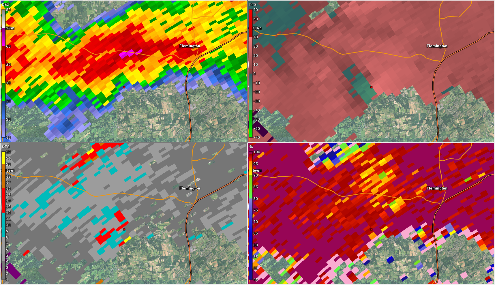 |
| Figure 1: TEWR radar reflectivity loop for the 0.3 degree elevation angle from 1902 UTC to 1916 UTC 17 July 2021. Rotation associated with this storm prompted a Tornado Warning. This is a remarkably good look at the wrapping up of this circulation as it approached the TEWR radar site, with a pronounced hook echo seen. Velocity data (archives for which are unavailable) also showed evidence of a velocity couplet. A funnel cloud was sighted with this storm, and several impressive and ominous photos and videos of strong rotation were received. However, no damage was reported in the area, and there is no indication a tornado ever touched down. | Figure 2: KDIX radar reflectivity factor (z; top left), storm relative velocity (SRM; top right), spectrum width (w, bottom left) and correlation coefficient (CC; bottom right) for the 0.8 degree elevation angle valid at 2117 UTC 17 July 2021. This area of rotation near Flemington also prompted a Tornado Warning. Good vertical continuity of 20 to 25 kt of rotational velocity was observed for several volume scans over the lowest 3 to 4 elevation angles. This area experienced severe thunderstorms in its vicinity for several hours, and a number of reports of downed trees and power lines were received. However, none appeared to occur in concert with this area of rotation. Should a tornado have occurred, confirming it likely would have been difficult due to the long duration of severe storms producing various directions of straight line wind damage as the storms evolved. |
 |
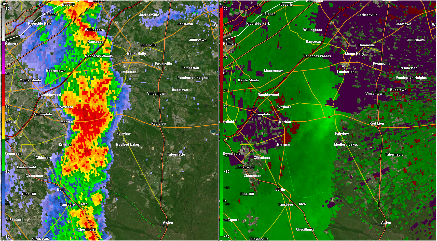 |
| Figure 3: KDIX radar reflectivity loop for the 0.5 degree elevation angle from 2030 UTC 17 July 2021 to 0030 UTC 18 July 2021, at approximately 30 minute intervals. Repeated rounds of convection can be seen affecting the same areas of central and northern New Jersey, especially Hunterdon County. Rainfall totals up to 6 inches were reported in the area. Significant flash flooding occurred. A number of wind damage reports were also received, as these storm clusters were severe for much of their lifespan. An outflow boundary can also be seen surging southward away from the convection. | Figure 4: KDIX radar reflectivity factor (left) and base velocity (right) for the 0.5 degree elevation angle valid at 0019 UTC 18 July 2021. An intense straight line wind event occurred in the area of Medford, NJ around this time. The bright green colors indicate radar estimated wind speeds of near to above 70 mph. A small bowing structure appears evident in the reflectivity. Numerous reports of downed trees and power outages were received. Another line of severe convection would move through Burlington County and surrounding areas about 2 hours later, which would produce additional wind damage and a tornado several miles further northeast. |
 |
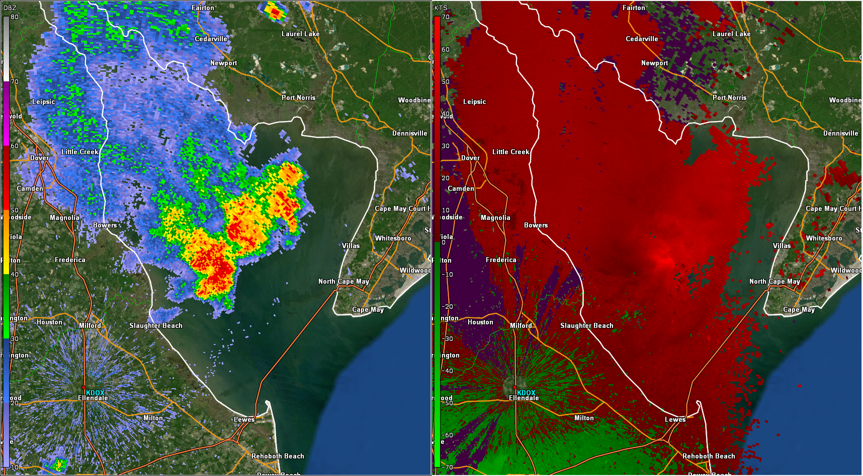 |
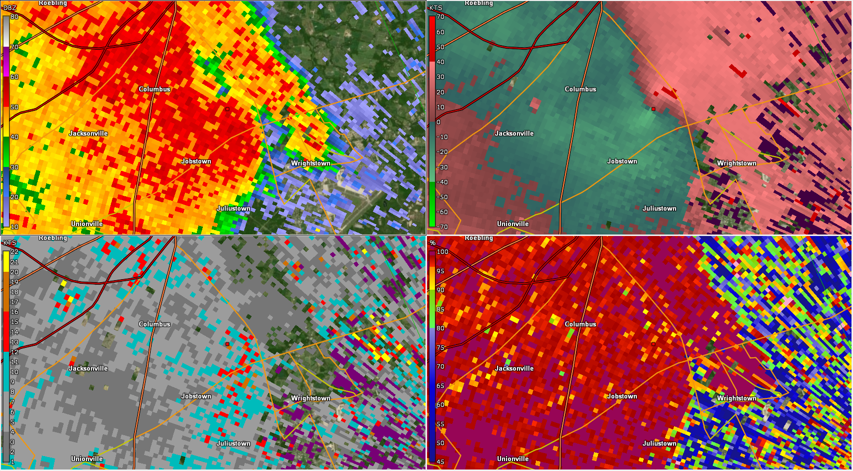
| Figure 5: Same as Figure 2 but for the 0.5 degree elevation angle, valid at 0230 UTC 18 July 2021. The Burlington County, NJ tornado was near its peak intensity at this time. The reflectivity and velocity data show a classic QLCS tornado, with about 40 kt of rotational velocity present, a typical value for EF-0 or EF-1 tornadoes. The CC and spectrum width data are unimpressive, however. There is no evidence of a tornado debris signature (TDS) in the CC data, and while spectrum width values are somewhat elevated within the circulation, they lack the strong maximum often associated with the chaotic circulation of a tornado. As is often the case in our region, damage produced by this tornado was comparable to several other areas of straight line wind damage across NJ and PA. | Figure 6: KDOX radar reflectivity factor (left) and base velocity (right) for the 0.5 degree elevation angle valid at 0122 UTC 18 July 2021. In another example of this event’s complex evolution, a small cluster of storms formed with the help of an outflow boundary over eastern Delaware, and intensified over Delaware Bay. While fairly innocuous in reflectivity, the velocity data reveals strong winds within the southernmost core. A wind gust of 78 mph was measured at Brandywine Shoal Light on Delaware Bay. The storm moved into Cape May County, but weakened significantly as it moved ashore, an occurrence which is frequently observed for storms in that area. |


 Coastal Flood
 Marine Forecasts
 Text Products
 Climate Information
 Skywarn
 Submit Storm Report
 Weather Event Archives
 Forecast Discussion
 Emergency Managers
 Briefing Page
 Follow us on YouTube