Overview
|
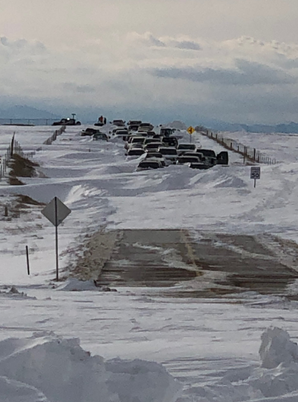
On March 13th, 2019 an extremely powerful low pressure system developed over southern Colorado, setting a record for the lowest pressure recorded over Colorado, bringing widespread rainfall over the plains, creating a blizzard over El Paso County, and dropping feet of snow over the mountains. According to local news sources, around 1,500 motorists were stranded over northern El Paso County. According to CDOT, I-25 north of Woodmen Road closed at 11:23 AM MDT due to "adverse weather conditions" and reopened during the later afternoon hours on March 14th. The lowest recorded pressure was 970.4 hPa over Lamar, Colorado, which is the official state record for lowest pressure ever recorded outside of a tornado. KPUB (Pueblo, Colorado) recorded a 974.2 hPa surface pressure at 9:00 AM MDT, which is a record for the lowest pressure over Pueblo. So what are the impacts of an state record for the lowest pressure recorded? Let's break it up by location: KCOS (City of Colorado Springs Municipal Airport): So how does this happen? Click on the "Environment" tab to find out. |
|
Photos & Video
 |
 |
 |
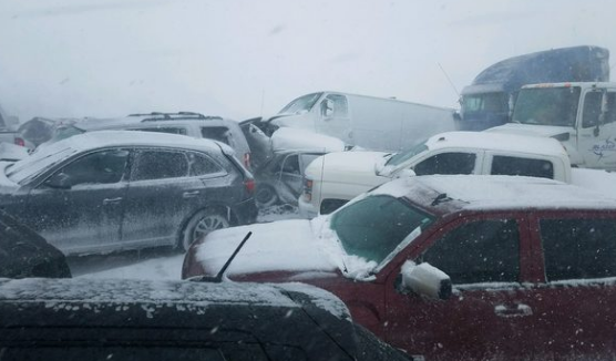 |
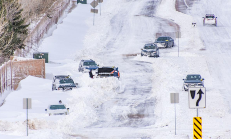
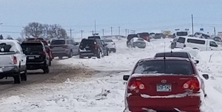
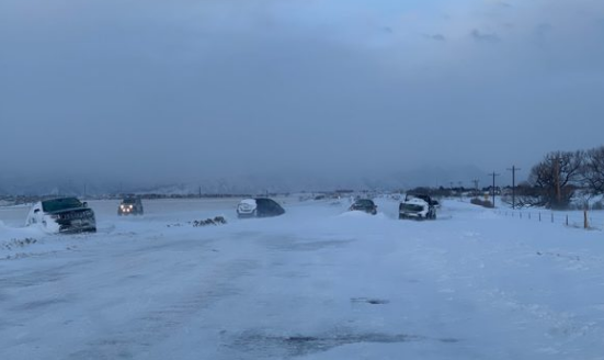
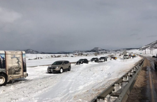
| Abandoned Cars on Baptist Road in El Paso County; Courtesy of Colorado Springs Gazette | Abandoned Cars on Woodmen Road in El Paso County; Courtesy of KOAA | Abandoned Cars on Woodmen Road in El Paso County; Courtesy of the Colorado Springs Gazette | Near Greenland, Colorado; Courtesy of KOAA |
 |
 |
 |
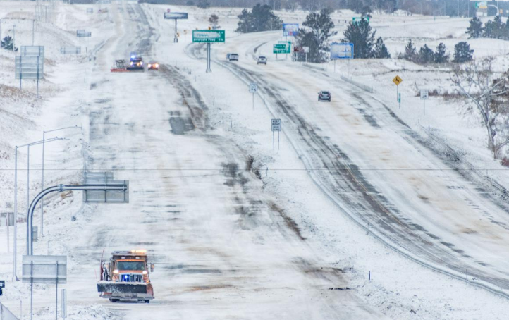 |
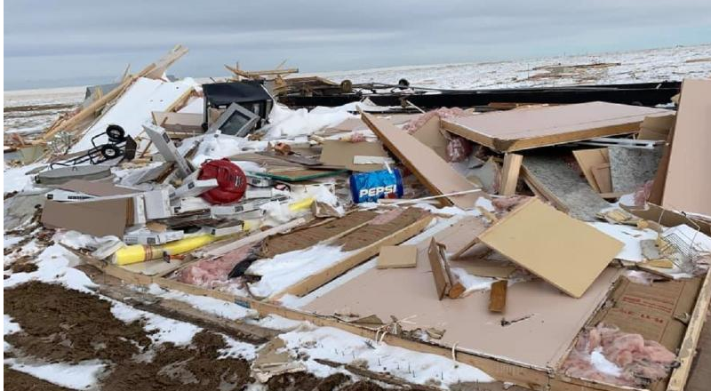
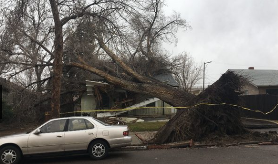
| Abandoned Cars on I-25; Courtesy of Douglas County Sheriff | I-25 North of Colorado Springs | Destroyed Home located in eastern El Paso County; Courtesy of the Colorado Springs Gazette | I-25 and Baptist Road After the Storm; Courtesy of the Colorado Springs Gazette |
 |
 |
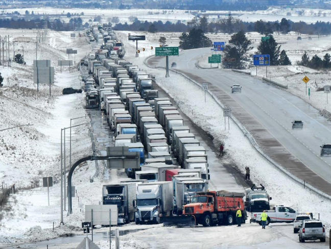 |
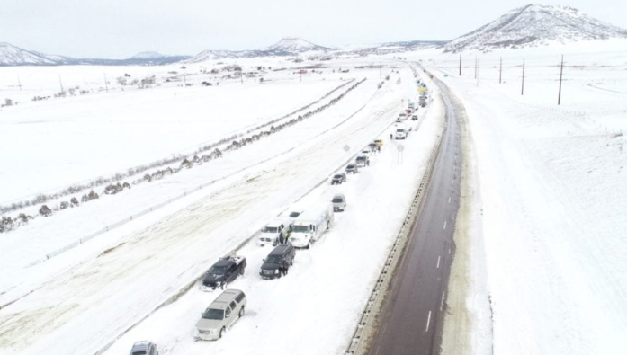
| Courtesy of Arapahoe Sheriff | Tree Toppled in Pueblo | Traffic Waiting for I-25 to Reopen |
Radar
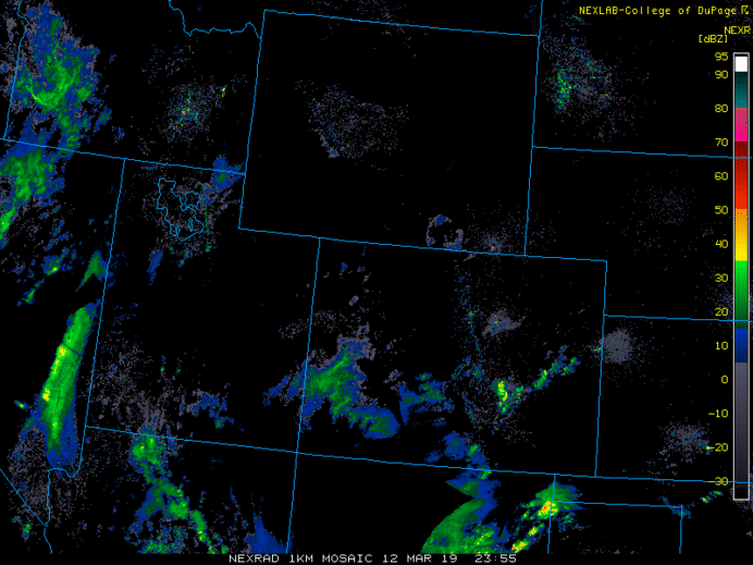 |
| Composite Radar Loop of the Event, images courtesy of UCAR's "MMM" Archive |
 |
| Gravity Waves Formed off of the Palmer Divide (Ripples Located in the Green) |
Storm Reports
- - 000000
WRKKTS
NOUS45 KPUB 141734
PNSPUB
COZ058>089-093>099-150534-
Public Information Statement
National Weather Service Pueblo CO
1134 AM MDT Thu Mar 14 2019
...SNOWFALL REPORTS...
Location Amount Time/Date Lat/Lon
...Wet Mountains between 6300 and 10000Ft...
7 NW San Isabel 11.3 in 1020 PM 03/13 38.06N/105.14W
1 W Rosita 10.6 in 0727 PM 03/13 38.10N/105.35W
...Wet Mountain Valley Below 8500 Ft...
5 W Westcliffe 5.0 in 0857 PM 03/13 38.14N/105.56W
5 W Westcliffe 2.5 in 0524 PM 03/13 38.14N/105.56W
...Teller County/Rampart Range above 7500fT/Pike's Peak Between 7500 And 11000 Ft...
Woodland Park 8.0 in 1243 PM 03/13 39.00N/105.05W
1 WSW Woodland Park 8.0 in 1207 PM 03/13 38.99N/105.07W
4 N Florissant 6.7 in 0719 PM 03/13 39.01N/105.29W
4 N Florissant 5.8 in 1139 AM 03/13 39.01N/105.30W
1 NNW Woodland Park 5.5 in 1214 PM 03/13 39.01N/105.06W
1 W Woodland Park 15.0 in 0942 PM 03/13 39.00N/105.07W
1 W Woodland Park 13.0 in 0512 PM 03/13 39.00N/105.07W
1 W Woodland Park 11.0 in 0109 PM 03/13 39.00N/105.07W
...Southern Sangre De Cristo Mountains Between 7500 and 11000 Ft...
7 E Fort Garland 12.0 in 0452 PM 03/13 37.44N/105.30W
...Northern El Paso County/Monument Ridge/Rampart Range Below 7500 Ft...
3 ESE Falcon 8.0 in 0300 PM 03/13 38.92N/104.56W
2 N Black Forest 7.0 in 0338 PM 03/13 39.05N/104.70W
6 ENE Black Forest 7.0 in 0608 PM 03/13 39.06N/104.60W
3 NW Black Forest 6.5 in 0146 PM 03/13 39.04N/104.74W
2 NNE Monument 4.0 in 0225 PM 03/13 39.13N/104.86W
2 N Black Forest 3.0 in 1137 AM 03/13 39.05N/104.70W
2 ENE Monument 16.0 in 0700 AM 03/14 39.11N/104.83W
3 NW Black Forest 13.5 in 1200 AM 03/14 39.04N/104.74W
3 NW Black Forest 10.5 in 0625 PM 03/13 39.04N/104.74W
2 NNE Monument 10.0 in 0318 PM 03/13 39.13N/104.86W
...Eastern Sawatch Mountains above 11000 Ft...
1 NNW Monarch Pass 12.0 in 0726 AM 03/14 38.51N/106.33W
...Eastern San Juan Mountains Above 10000 Ft...
1 SE Wolf Creek Pass 52.0 in 0753 AM 03/14 37.47N/106.79W
...Colorado Springs Vicinity/Southern El Paso County/Rampart Range Below 7400 Ft...
5 SSE Air Force Academy 9.0 in 0400 AM 03/14 38.94N/104.83W
3 ENE Manitou Springs 5.0 in 0400 PM 03/13 38.87N/104.86W
2 WNW Peterson AFB 3.0 in 0400 AM 03/14 38.84N/104.74W
2 NW Colorado Springs 2.5 in 1050 AM 03/14 38.85N/104.85W
...RAINFALL REPORTS...
Location Amount Time/Date Lat/Lon
...Pueblo Vicinity/Pueblo County Below 6300 Feet...
3 S Pueblo 0.87 in 0426 PM 03/13 38.26N/104.63W
...Colorado Springs Vicinity/Southern El Paso County/Rampart Range Below 7400 Ft...
2 NW Colorado Springs 1.40 in 1048 AM 03/14 38.85N/104.85W
...WIND REPORTS...
Location Speed Time/Date Lat/Lon
...Springfield Vicinity/Baca County...
8 S Springfield 74 MPH 0433 PM 03/13 37.28N/102.61W
8 S Springfield 66 MPH 0251 PM 03/13 37.28N/102.61W
8 S Springfield 63 MPH 1254 PM 03/13 37.28N/102.61W
4 SW Campo 62 MPH 0859 AM 03/14 37.06N/102.63W
...Pueblo Vicinity/Pueblo County Below 6300 Feet...
Pueblo Airport 78 MPH 0254 PM 03/13 38.28N/104.52W
Pueblo Airport 75 MPH 0248 PM 03/13 38.28N/104.52W
Pueblo Airport 74 MPH 0100 PM 03/13 38.28N/104.52W
Pueblo Airport 70 MPH 1219 PM 03/13 38.28N/104.52W
1 NW Pueblo 63 MPH 0427 PM 03/13 38.31N/104.64W
7 SE Boone 63 MPH 0256 PM 03/13 38.17N/104.16W
1 SSE Pueblo West 50 MPH 0125 PM 03/13 38.30N/104.75W
...Northern El Paso County/Monument Ridge/Rampart Range Below 7500 Ft...
4 S Black Forest 84 MPH 1247 PM 03/13 38.95N/104.71W
2 N Black Forest 81 MPH 0530 PM 03/13 39.05N/104.70W
2 N Black Forest 64 MPH 1200 PM 03/13 39.05N/104.70W
1 WNW Palmer Lake 62 MPH 0411 PM 03/13 39.12N/104.92W
Falcon Airport 59 MPH 1155 AM 03/13 38.95N/104.57W
...Lamar Vicinity/Prowers County...
Lamar Airport 82 MPH 0439 PM 03/13 38.07N/102.69W
Lamar Airport 78 MPH 0322 PM 03/13 38.07N/102.69W
Lamar Airport 67 MPH 0829 AM 03/14 38.07N/102.69W
17 NW Two Buttes 60 MPH 0930 AM 03/14 37.75N/102.60W
...La Junta Vicinity/Otero County...
La Junta Airport 89 MPH 0346 PM 03/13 38.05N/103.51W
La Junta Airport 83 MPH 0246 PM 03/13 38.05N/103.51W
4 S Cheraw 81 MPH 0240 PM 03/13 38.06N/103.51W
La Junta Airport 67 MPH 0120 PM 03/13 38.05N/103.51W
...Del Norte Vicinity/Northern San Luis Valley Below 8500 Ft...
Saguache 61 MPH 1154 AM 03/13 38.10N/106.18W
...Crowley County...
18 SW Forder 71 MPH 0215 PM 03/13 38.47N/103.92W
...Colorado Springs Vicinity/Southern El Paso County/Rampart Range Below 7400 Ft...
2 S Peterson AFB 96 MPH 0118 PM 03/13 38.80N/104.70W
6 SW Truckton 85 MPH 0203 PM 03/13 38.66N/104.26W
6 SW Truckton 82 MPH 0113 PM 03/13 38.66N/104.26W
6 SW Truckton 81 MPH 1242 PM 03/13 38.66N/104.26W
Colorado Springs Airport 79 MPH 1254 PM 03/13 38.81N/104.71W
Colorado Springs Airport 74 MPH 1148 AM 03/13 38.81N/104.71W
Observations are collected from a variety of sources with varying
equipment and exposures. We thank all volunteer weather observers
for their dedication. Not all data listed are considered official.
$$
Environment
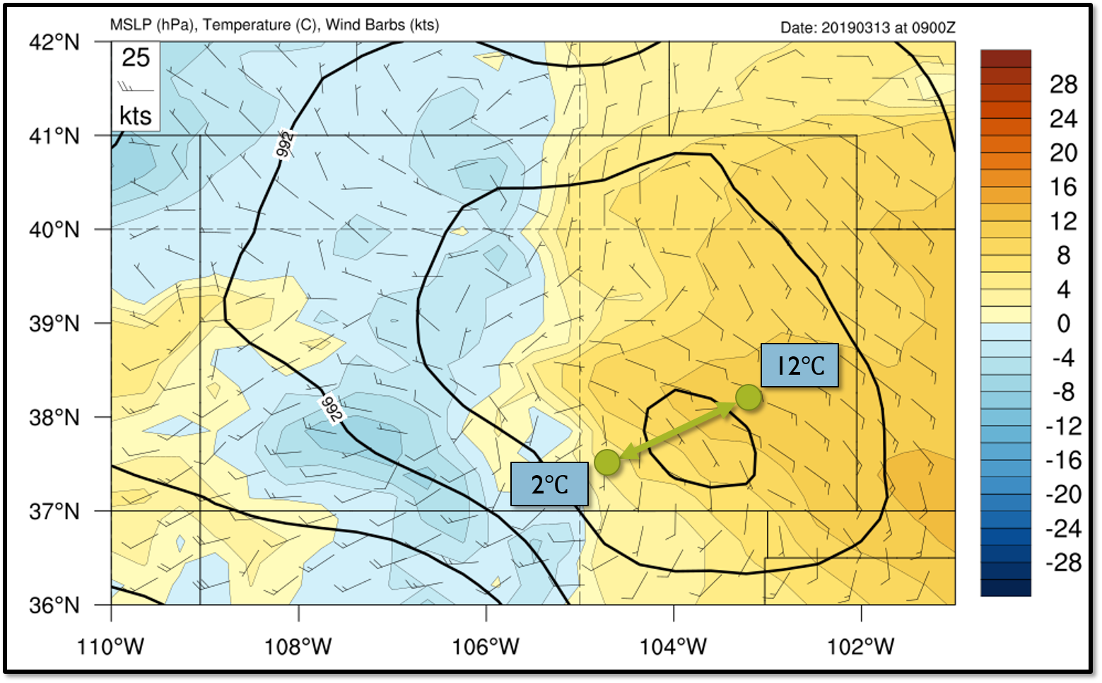
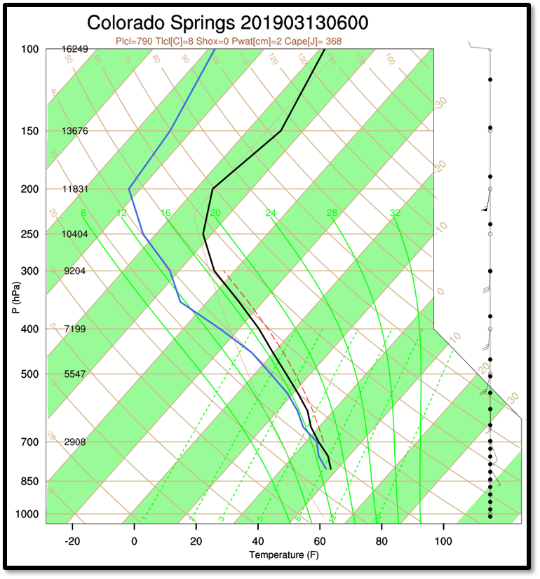
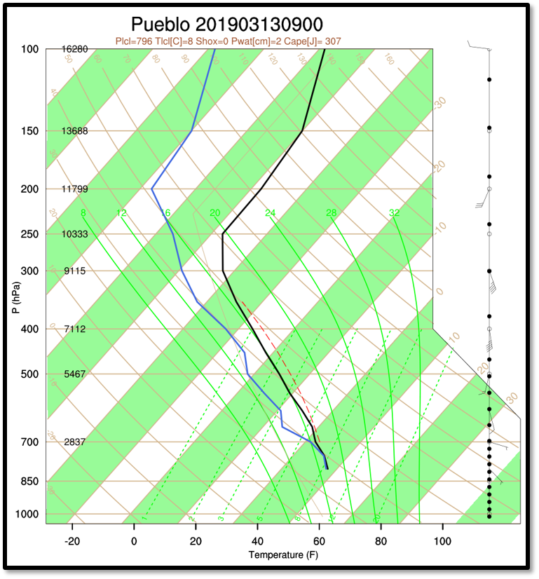
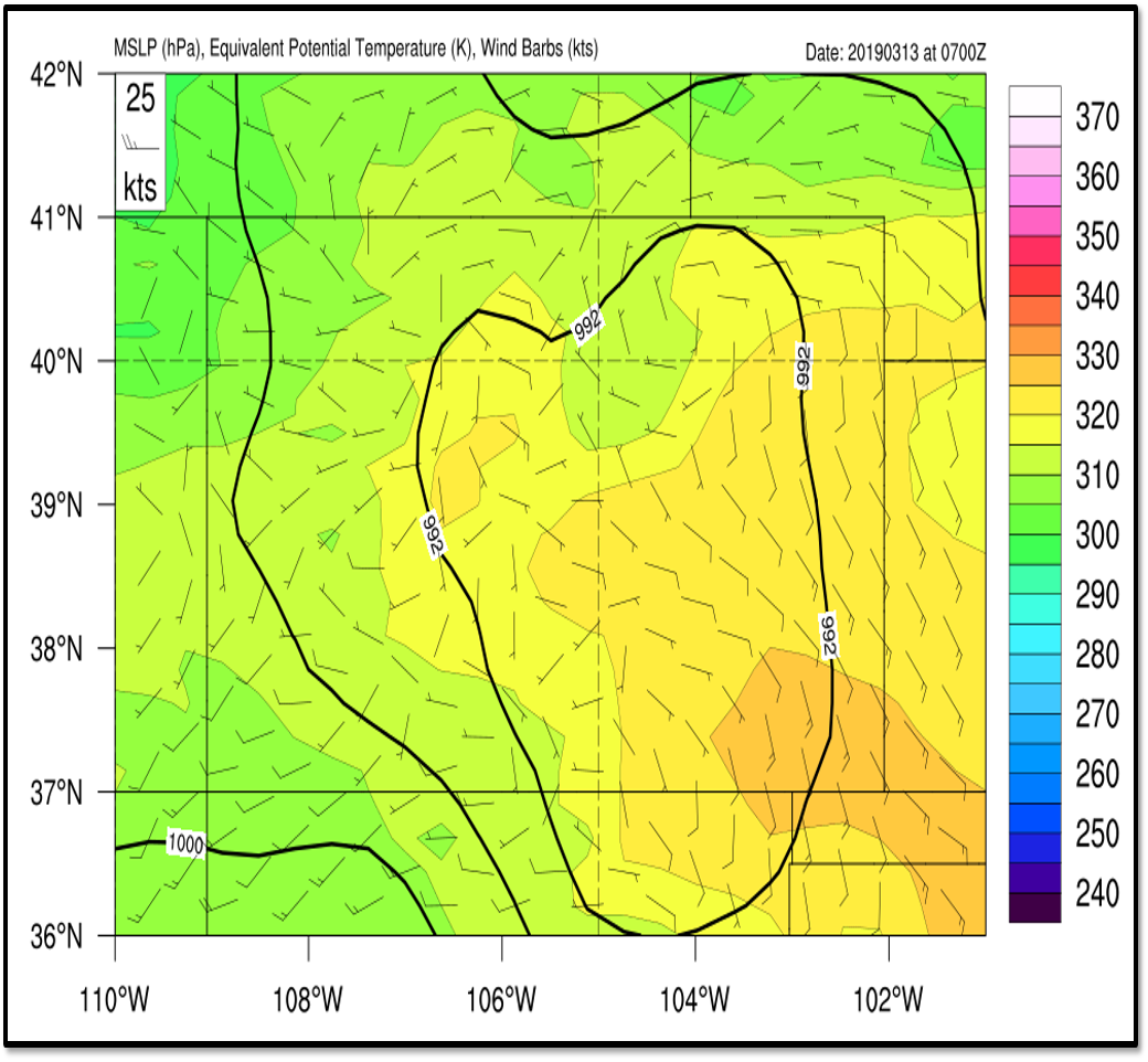
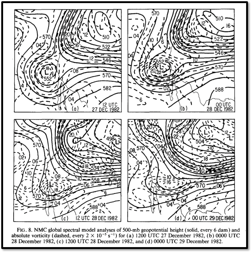
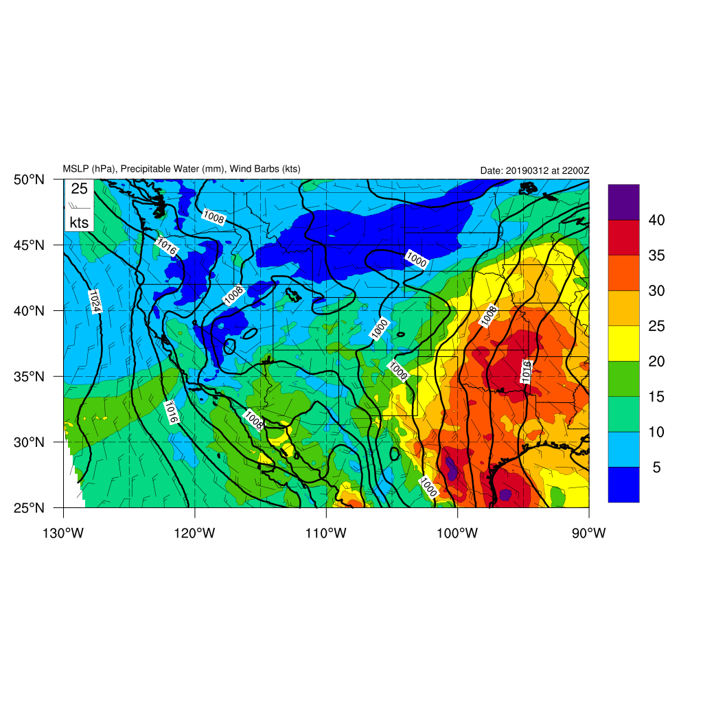
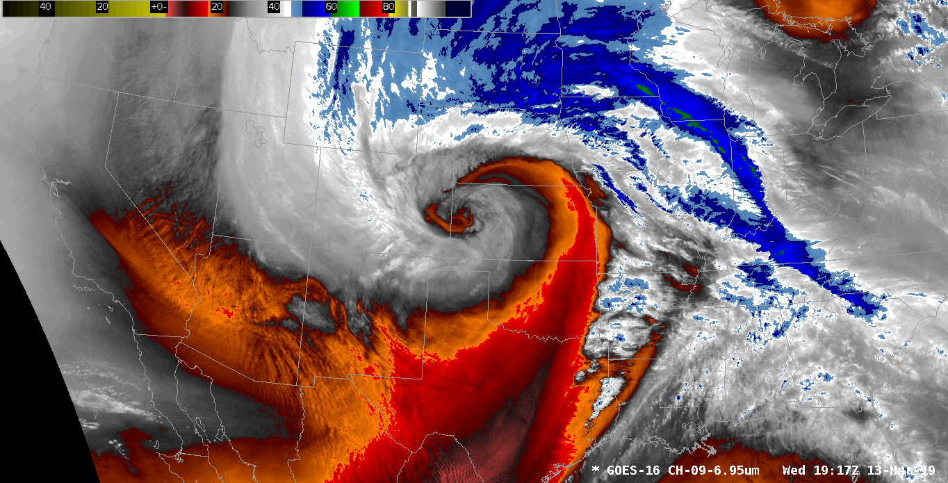
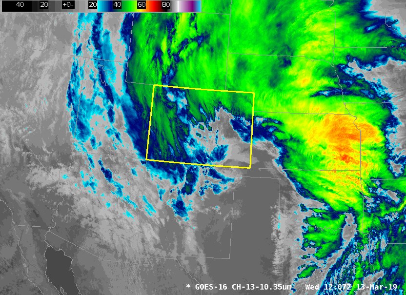
The 13 March 2019 bombogenesis event was a historically strong mid-latitude cyclone that was the result of lee cyclogenesis, baroclinic cylogenesis, and two troughs merging together. The trough merger is what made this particular storm the strongest low pressure center in Colorado history. According to Gaza and Bosart (1990) some characteristics of a trough merger are as follows: 1) Enhance baroclinity in trough 2) Reduce static stability ahead of trough axis and 3) Augment the moisture available for precipitation. Figures 1-4 indicate that a trough merger occurred. Fig. 1 represents the baroclinicity at the surface, with a 10 C temperature gradient with 70 miles, Fig 2-3 illustrate instability ahead of the trough by showing thermodynamic soundings of the atmosphere by proxy of CAPE in the atmosphere at KPUB and KCOS (307 J/kg at 3AM MDT at KPUB and 368 J/kg at KCOS), and Fig 4. surface theta-e plots show the augmented moisture advected from the Pacific and Gulf of Mexico. Figure 5 illustrates a schematic of lee cyclogenesis. Historically, the last major trough merger to occur was the 1982 Christmas blizzard (Fig 5), which set record December low pressure values over the southeastern plains (Fig. 6), which debilitated Colorado and much of the midwest. Another feature to be pointed out a moisture plume extending from the Pacific Ocean towards southwestern Colorado (Fig. 7). As the LSR summary section of this write up states, Wolf Creek Ski Area saw 52 inches of snow from this event. The Pacific moisture, orographics, and implied dynamics was located over the mountains (Fig 8) resulted in heavy snowfall over the mountain.
The "bombogenesis" event is best described in sections. So the sections will be separated into:
1). Pre-cyclogenesis (the overnight hours)
2). "Bombogenesis" (the morning hours)
3). Orographics (the early afternoon hours)
1) Pre-cyclogenesis:
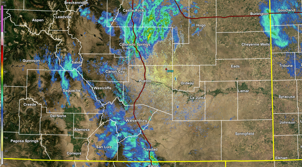
During the late evening hours and overnight hours of March 12th and March 13th, there were rain bands that formed over the I-25 corridor and the eastern plains. The rain band formations were created by warm air advection (WAA) from the south and southeast of Colorado. Generally, the Raton Mesa creates a rain shadow (compressional heating due to downslope flow resulting in temperatures warming and moisture content remaining stationary, meaning a drier atmosphere relative to where the air came from), but in this case the WAA overcame the effects of orographics to create overnight rain showers (Fig 9). The high temperatures on March 13th actually came during the overnight periods. The extra moisture from the Gulf of Mexico and the stratus deck kept the temperature warm overnight, hence the rain bands and not snow bands.
2). "Bombogenesis":
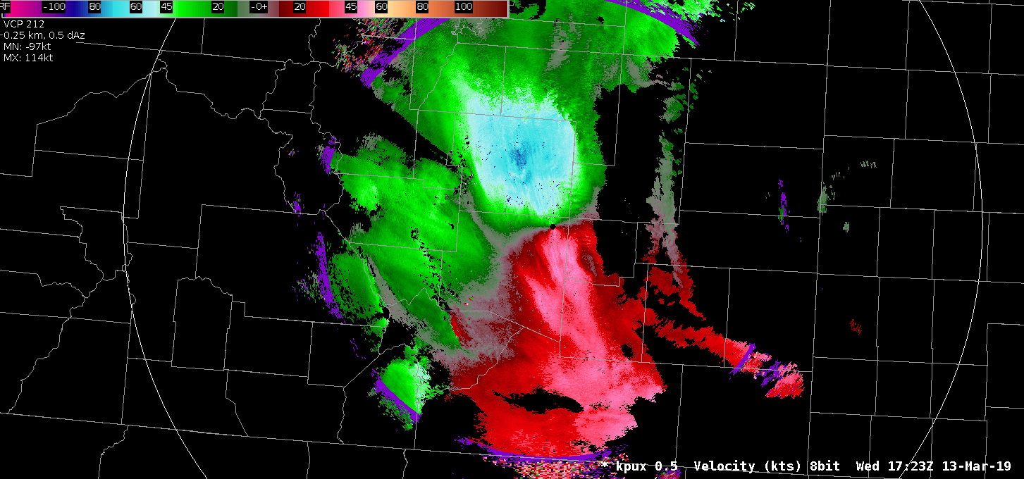
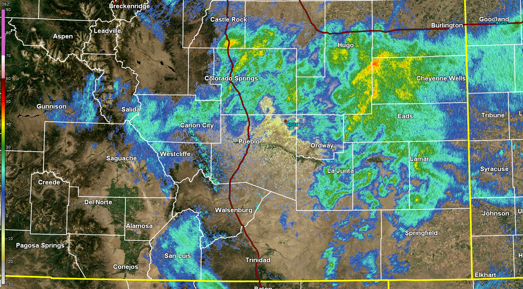
So how did this happen? Why did we see the strongest low pressure system ever recorded in Colorado? Here over the Front Range, we see a phenomena called Lee Cyclogenesis (Fig. 12). Essentially what happens is the upper level low pressure system ejects off of the Rocky Mountains and over the high plains, during that time the upper level circulation must quickly go from the higher elevations all the way down to the lower elevations which causes the low pressure system to stretch and tighten up, causing it to rotate more quickly and therefore intensify. The best way to describe this phenomena is by comparing it to ice skater spinning. When the ice skater has their arms out, they will spin slower, but when they bring in their arms tight to their body, they spin more quickly, which is an application of the conservation of angular momentum. The same thing that was previously described happens to a low pressure system ejecting off of the Rocky Mountains. Lee cyclogenesis happens all of the time, so what made this special? Well, while the low pressure center ejected off of the Rockies there was a baroclinic zone located over southern Colorado. A baroclinic zone is a region in which a temperature gradient (temperature difference) exists, which is also helps intensify the low pressure system (Fig 7). In this particular case, there was a 10C temperatures difference within 50 miles. So there was lee cyclogenesis and baroclinic cyclogenesis occurring, but again, this is a relatively common occurrence. There was another element that helped the cyclone to explosively intensify, and that was a trough merger between a low pressure center located over the Pacific Northwest and a cut-off upper level low over the American Southwest (Fig. 8). All of these interaction created the "bombogenesis" event. The rapid cyclogenesis caused "wrap-around" precipitation bands on the back side of the low pressure center. This kind of precipitation occurs when the upper level low and the surface transition to becoming vertically stacked, or reach the occlusion stage of its life cycle. Isentropic lift (upglide; warm conveyor belt) is responsible for this type of precipitation. The wrap-around precipitation is illustrated in Fig. 10. The timeline of when rain turned into snow and when blizzard conditions started is located in the "Overview" section of this write-up.
3). Orographics:
The final stage is when the low pressure system was located far enough east that the dynamics were overwhelmed by the orographics. The very strong northerly winds (downslope) off of the Palmer Divide ending precipitation over southern El Paso County and Pueblo County is illustrated in Fig. 11. Blizzard conditions still continued over parts of southern El Paso County and all of northern El Paso County (see the "Overview" section), but rain stopped over Pueblo County and south. Generally, the downslope flow off of the Palmer Divide is stronger than the dynamics of the low pressure system, but in this case, the dynamics were stronger, at least for the middle of the event. A key lesson in Colorado forecasting is that topography manipulates the weather around us, and the topography manipulated the outcome of this explosive cyclogenesis event. During afternoon hours, the strongest winds were observed and which was caused (partly) by the topography as well. There was ageostrophic accelerations to the south due to wind hitting the mountains and being forced south, evaporational cooling from the downslope effects of the Palmer Divide causing a density acceleration to the lower elevations, and the shear intensity of the low pressure system.
 |
 |
 |
| Fig 1. Surface Temperatures at 3AM MDT on 3/13/19. NCL Graphic Courtesy of Klint Skelly. | Fig 2. Skew-T Diagram at 12AM MDT on 3/13/19 over Colorado Springs. NCL Graphic Courtesy of Klint Skelly. | Fig 3. Skew-T Diagram at 12AM MDT on 3/13/19 over Pueblo. NCL Graphic Courtesy of Klint Skelly. |
 |
 |
 |
| Fig 4. Surface Theta-E Plot of Southern Colorado at 1AM MDT on 3/13/19. NCL Graphic Courtesy of Klint Skelly. | Fig 5. Synoptic Set-Up of the Halloween Blizzard of 1982, which Highlights a Trough Merger | Fig 6. Record Low Pressure Map for December Highlighting the Magnitude of the Halloween Blizzard on 1982. Courtesy: David Roth; WPC |
 |
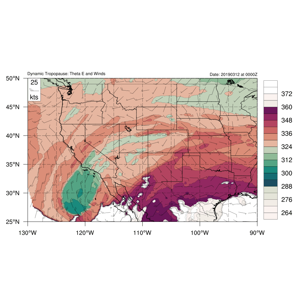 |
| Fig. 7 Precipitable Water Plot Highlighting Available Moisture from the Pacific and from the Gulf of Mexico. NCL Graphic Courtesy of Klint Skelly. | Fig. 8 Dynamic Tropopause plots highlighting the trough merger over Colorado. NCL Graphic Courtesy of Klint Skelly. |
 |
 |
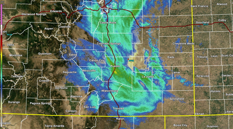 |
| Fig. 9 Warm Air Advection Rain Bands during the early morning hours on March 13th, 2019 (0.5 Z) | Fig. 10 Wrap Around Precipitation Formed from Explosive Cyclogenesis during the morning hours on March 13th, 2019 (0.5 Z) | Fig. 11. Precipitation Ending Over Pueblo and Southern El Paso Counties during the early afternoon hours on March 13th, 2019 (0.5 Z) |
 |
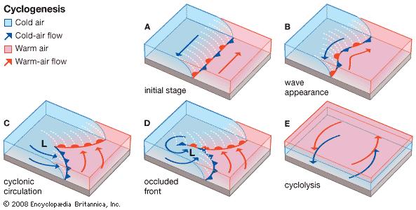 |
| Fig. 12 Schematic of Lee Cyclogenesis over the northern Hemisphere. Graphic Courtesy of Klint Skelly | Fig. 13 Cyclogenesis due to Baroclinicity |
 |
Media use of NWS Web News Stories is encouraged! Please acknowledge the NWS as the source of any news information accessed from this site. |
|


 Follow us on YouTube