Virtual Tour Navigation: Go Back | Go Forward | Tour Directory
Page: 1 2 3 4 5 6 7 8 9 10 11 12 13 14 15 16 17 18
During severe weather operations we will supplement our staffing with additional personnel to handle the increased workload. We will often have more than one meteorologist monitoring the radar. We do this by breaking up our CWA into sectors. This allows the radar operator to focus on a smaller region that will typically have more homogeneous meteorological conditions with storms that possess a similar storm structure and severe weather threat. In addition to the one, two, or three meteorologists actively analyzing the radar and issuing warnings or statements, other meteorologists will be updating our regular forecast products, the gridded forecast database, locating ground truth reports of damage, briefing emergency officials, and relaying damage reports to the public, the media, and other NWS offices.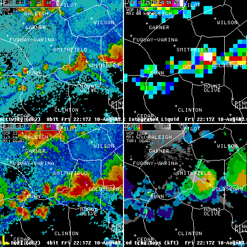
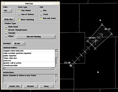
Once a severe thunderstorm or tornado is anticipated or is observed, a Severe Thunderstorm Warning or Tornado Warning will need to be issued. We use a program called WarnGen which is used on AWIPS to quickly and accurately produce severe weather warnings or statements. The radar operator specifies the required warning type, identifies the current storm location, creates a forecast track, and then identifies an area (polygon) which is threatened by the severe weather. The radar operator then specifies the warning duration, adjusts the content of the warning and selects what safety information (Call to Action Statements) is needed. The radar operator clicks on a button and WarnGen creates a pop-up window that contains the text of the severe weather warning. The text automatically includes the counties and cities in the path of the storm, the speed and direction the storm is moving, and how long the warning will be in effect for the affected areas. After quickly proofreading the text, the warning is issued.
Our computer system automatically sends the warning out to the Emergency Alert System, the NOAA Weather Wire, and the internet so our users can access the information. The warning is also relayed immediately to our NOAA All Hazards Radio system which automatically plays the warnings on radio transmitters in the affected areas. See the next page in the tour for more information on NOAA All Hazards Weather Radio.
Since the radar can only tell us what is happening in the sky, spotter reports are essential to severe weather operations. They provide critical feedback on conditions at the ground allowing us to more effectively interpret and utilize the radar data. They can also pass along important details such as the extent of storm damage, the size of hailstones, and specific details on the impacts of flooding in a community.
 Event summaries and case studies for dozens of severe weather events are available on our Event Summaries, Case Studies and Event Maps Web Page.
The most recent short-fused severe weather warnings and statements can be seen below:
Severe Thunderstorm Warning
Tornado Warning
Severe Weather Statement
Flash Flood Warning
Flash Flood Statement
Special Weather Statement
Local Severe Weather Report


 Heat Safety
 Statewide Maps
 Forecaster Discussion
 Follow us on YouTube