 |
The National Weather Service Building a Weather-Ready Nation |

Expected Fire Weather Conditions:
Sunday and Labor Day: Slightly elevated fire weather conditions across portions of southern WY where gusty southwest winds will combine with afternoon relative humidity in the 20 to 25 percent range. Otherwise the sharp trend of decreasing fire weather conditions will continue as cooler and inclement weather continues Sunday. On Monday most of the precipitation will be confined across northwest and northern Wyoming. Minor mountain snow accumulations could occur Sunday night and Monday. Please see the special weather statement for more details.
Looking for information about fuel conditions, precipitation and temperature trends, and drought conditions? You can find it all on our specialized fire weather website.
Evacuations and Closures:
There are local area and trail closures in Grand Teton and Yellowstone national parks. Please check with national park rangers and/or visitor services for the latest closures and re-openings. Berry Fire closure maps can be found at inciweb.nwcg.gov/incident/maps/4954/ and closure maps for the Yellowstone fires can be found at inciweb.nwcg.gov/incident/maps/4944/. All main highways and roads are open in both parks.
 |
|
 |
 |
|
|
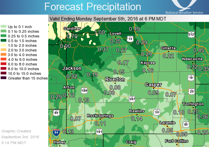
Forecast precipitation amounts from Saturday night through the day Monday. |
 |
 |
 |
|
Click to Enlarge High Temperatures expected |
Click to Enlarge Minimum Relative Humidity |
Click to Enlarge Maximum Wind Gust |
 |
 |
.jpg "Click to enlarge") |
|
 |
Monitor our Severe Weather Summary Page for current Warnings, Watches, and Advisories. What's the difference? |
 |
Check the latest Weather Story graphic for an overview of the area forecast. |
 |
Check out what's on the radar. Riverton | Pocatello | Cheyenne | Billings | Salt Lake City | Rapid City | Mosaic |
| Submit storm reports/images and keep up to date with us on Facebook! | |
 |
Other reporting methods include eSpotter, email (cr.wxriw@noaa.gov), or by phone at 1-800-211-1448. |
 |
Check the latest Public Information Statement for the latest storm reports. |
| Monitor current road conditions by visiting the Wyoming Dept. of Transportation (WYDOT) or by calling 5-1-1. |
|
Learn more about the National Weather Service's efforts to build a Weather-Ready Nation! |


.jpg "Click to enlarge")


 Follow us on YouTube