National Weather Service United States Department of Commerce
The National Weather Service and other local emergency services partners have created this resource to detail the higher probabilities of Flash Flood and Debris Flows across western Wyoming for those people affected by the 2019 Roosevelt Fire.
 

***While this page highlights the burn scar associated with the Roosevelt Fire, these impacts can occur down slope and/or downstream of any burn area, big or small.  Please contact local officials if you are unsure of your risk.***

Roosevelt Wildfire Burn Scar Area

Greatest Risk Area

  • All low lying areas, flood plains, current and historic channels
  • Anywhere that gravity will move water and debris
  • Note: Water and debris can be transported into areas that don't normally see water flow. All areas in and downslope of burned areas should be aware of the increased probability of Flash Flood and Debris Flows

Creeks / Streams Impacted

  • Upper Hoback River
    (above the Jamb Creek confluence)
  • South Fork Hoback River
  • Kilgore Creek
  • Sled Runner Creek
  • Fisherman Creek
  • South Fork Fisherman Creek
  • Stub Creek
  • Muddy Creek

Other Impacted Areas

  • Hoback Ranches
  • Upper Hoback Road (Road 23174)
  • Fisherman Creek Road
  • Riggan Lane
  • Rim Road
  • Deer Haven Road
  • Some locations in Hoback Ranches will be more susceptible to flash flooding and debris flows than other areas (click here for a zoomable map).
Variables Affecting Magnitude of Flash Flood/Debris Flow:
  • Steepness of terrain above your location
  • Intensity of burn
  • Intensity of rainfall
    • Half inch of rain in less than one hour can result in a Flash Flood
    • Any high intensity rain over a short period of time can result in a Flash Flood
    • Age of burn scar
    • Threat lessens over time; highest probability the first year after the fire
  • Most burn areas will be flash flood prone for at least 2 years
Fontenelle Burn Scar Map

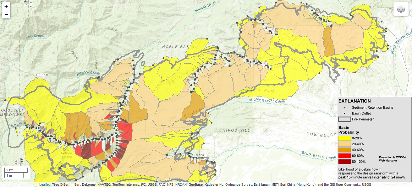
Click map above for close-up picture. Visit this link for a complete
overview of the Roosevelt Fire Burn Scar Hazard Assessment.

What should people who live near burn areas do to protect themselves from potential Flash Flooding and Debris Flows?

  • Have an evacuation/escape route planned that is least likely to be impacted by Flash Flooding or Debris Flows
  • Have an Emergency Supply Kit available
  • Stay informed before and during any potential event; knowing where to obtain National Weather Service (NWS) Outlooks, Watches and Warnings via the NWS, website, Facebook, Twitter, or NOAA Weather Radio
  • Be alert if any precipitation develops. Do not wait for a warning to evacuate should heavy precipitation develop!
  • Call 911 if you are caught in a Flash Flood or Debris Flow
  • Download or read online the "Post Wildfire Flash Flood and Debris Flow Guide" (PDF) created by the NWS office in Oxnard, CA
  • Additional Flood Safety information is available on the web here
  • Contact local officials for additional risk information and potential mitigation efforts