Long Lived Supercell tracks across the Huntington to Charleston Corridor Wednesday August 30th 2006.
A supercell thunderstorm crossed the urban corridor from Huntington to Charleston on Wednesday afternoon August 30th. This storm brought torrential rains, large hail, and damaging winds to the interstate 64 corridor. A supercell is a severe thunderstorm with a mesocyclone or deep rotating updraft.( Doswell and Burgess 1993). Supercells are the largest, most severe class of single cell thunderstorms. Supercells are usually found isolated from other thunderstorms, although they can sometimes be embedded in a squall line. Because they can last for hours, they are known as quasi-state storms. They usually produce copious amounts of hail, torrential rainfall, strong winds, and substantial downdrafts. Supercells also produce tornadoes with the mesocyclone, although only 30% or less do so.
Atmospheric conditions the day of the storm did not indicate the development of supercell storms across central West Virginia, let alone pass through the two largest cities in the state of West Virginia. The 21Z surface analysis from HPC (Figure 1) had low pressure across western North Carolina with a stationary front extending to the Alabama gulf coast. An inverted surface trough extended north from the attendant low location from western North Carolina to Bluefield, WV to Clarksburg, WV. Little, if any, sunshine was observed during the daytime hours, which kept the atmosphere in check. Convective parameters from the 18Z 10 km locally run workstation ETA (Figure 2) forecast 900 j/kg surface based CAPE, 700-500 mb lapse rates of 5.5 c/km, and a -5 C lifted index. The high resolution model did pick up on an area of enhanced shear over central West Virginia from 18Z to 21Z with 0-3 km storm relative helicity ranging from 125 m2/s2 to 175 m2/s2. Winds from the surface through 850mb were out of the northeast less than 10 knots. The 700mb winds shift to the south with the approach of a mid level trough, but also remained fairly week around 20 knots. Despite the mean layer wind from the surface to 500mb less than 20 knots, enough shear existed as the aforementioned trough bisected central West Virginia. Once supercells develop, they manufacture their own environment, and even the finest mesoscale model will not capture the true amount of shear and instability present.
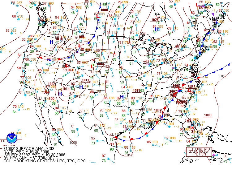
Figure 1: August 30th, 2006 21Z surface analysis from the Hydrometeorological Prediction Center (HPC)
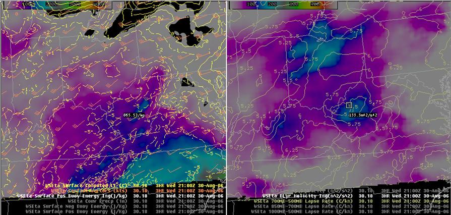
Figure 2: Three hour forecast from the 18Z 10km WSETA valid at 21Z August 30th 2006. The left panel contains surface based Lifted Index values (yellow contours), Corfidi vectors (red), and surface based cape imaged (j/kg). The right panel contains 700-500mb lapse rates (tan contours) with 0-3km storm relative helicity imaged. Areas of blue indicate locations where the WSETA predicts values of 100m2/s2 of helicity.
The first severe report came arrived at 1230 PM from Boyd County Kentucky where trees were toppled along Route 3 in Cannonsburg. At 505 PM, Summersville reported severe hail, which was the last report received for this event. In between, numerous trees and power lines were knocked down as the storm passed through Kanawha and Putnam counties, while hail the size of tennis balls occurred in northern portions of Kanawha County. Torrential rains accompanied this storm with reports of three inches in 30 minutes. Needless to say, this lead to flash flooding across counties in the path of the storm (Cabell, Putnam, and Kanawha). Marshall University's main campus in Huntington, WV shut down for a period of time due to high water surrounding some of the buildings. Storm total precipitation estimates from the Jackson, KY radar (Figure 3) were fairly consistent with amounts received from spotters and cooperative observers. Areas of purple and light green indicate excess of 3.5 inches for the duration of the event. Rainfall estimates in Kanawha County ran on the high side due to hail contamination; however two to three inches were common over northern parts of the county.
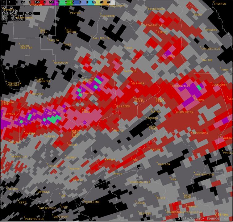
Figure 3: Storm total precipitation from the Jackson, KY radar. Areas of red indicate an inch or more with increasing amounts within the red shading.
As the storm reached western portions of Kanawha County it became clear that it meant business. The 1918Z 0.5 degree storm relative motion (SRM) off the Charleston, WV Doppler radar (Figure 4) illustrated frightening wind measurements just off the ground. A few pixels of hurricane force winds were analyzed east of Cross Lanes with a large area of 55 to 60 mph winds (light green). Area anemometers recorded speeds around 50 mph in Charleston, but wind gust to 70 mph were likely observed given velocity signatures from the Doppler radar.
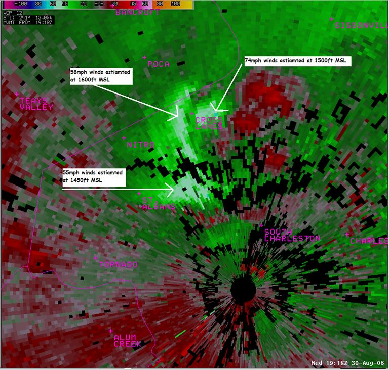
Figure 4: The 1918Z 0.5 degree storm relative velocity image from the Charleston, WV Doppler radar. Arrows indicate estimated wind speeds from the radar just above the surface.
As the storm passed north of Charleston, tennis ball to baseball size hail occurred at Capitol high school, damaging a number of vehicles, as windows were shattered by the large hail. The image below captures the hail which occurred in the Mink Shoals area near Capitol high school. Spotter reports said the hail took about an hour before it completely melted.
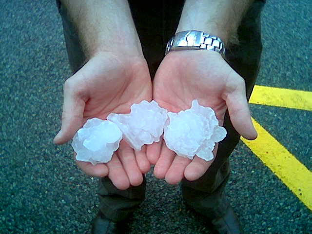
Figure 5: Tennis ball size hail that fell in the Mink Shoals area.
The supercell finally weakened as it encountered the Appalachians, not before hail and strong winds pummeled Nicholas County. A cross section of the storm indicated the strength of the updraft with the hail easily identified in Figure 6. The area of pink denoted at the end of the white arrow shows radar reflectivity of 65 dBZ and greater around 30,000 feet. Storms like the one captured below are not a yearly occurrence in the Charleston, WV forecast area.
It took five hours and 45 minutes for the supercell to traverse from Boyd County Kentucky to Nicholas County West Virginia. The average motion of the storm was 15 mph. All of the severe weather reports relayed to the National Weather Service are listed in the table below. Initially a funnel cloud was reported in Sissonville; however it was later confirmed as a microburst. The area was lucky as the supercell did not produce a tornado.
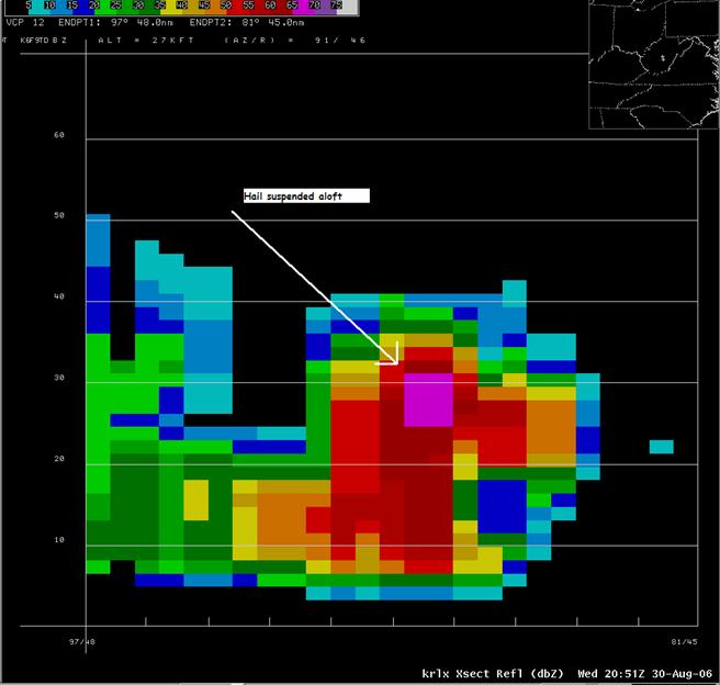
Figure 6: Cross section of the supercell as it crossed the Kanawha Nicholas County border at 2051Z.
Note: All data below are considered preliminary. The tornado report was later verified as a microburst and is denoted in the comments section.
|
TORNADO REPORTS |
||||||||||||||||||||||||||||||||||||||||||||||||||||||||||||||||||||||||||||||||||||||||||||||||||||||||||||||||||||||||||||||||||||||||||||||||
|
||||||||||||||||||||||||||||||||||||||||||||||||||||||||||||||||||||||||||||||||||||||||||||||||||||||||||||||||||||||||||||||||||||||||||||||||
|
FLASH FLOOD REPORTS |
||||||||||||||||||||||||||||||||||||||||||||||||||||||||||||||||||||||||||||||||||||||||||||||||||||||||||||||||||||||||||||||||||||||||||||||||
|
||||||||||||||||||||||||||||||||||||||||||||||||||||||||||||||||||||||||||||||||||||||||||||||||||||||||||||||||||||||||||||||||||||||||||||||||
|
WIND REPORTS |
||||||||||||||||||||||||||||||||||||||||||||||||||||||||||||||||||||||||||||||||||||||||||||||||||||||||||||||||||||||||||||||||||||||||||||||||
|
||||||||||||||||||||||||||||||||||||||||||||||||||||||||||||||||||||||||||||||||||||||||||||||||||||||||||||||||||||||||||||||||||||||||||||||||
|
HAIL REPORTS |
||||||||||||||||||||||||||||||||||||||||||||||||||||||||||||||||||||||||||||||||||||||||||||||||||||||||||||||||||||||||||||||||||||||||||||||||
|
References:
Doswell, C.A. III and D.W. Burgess, 1993: Tornadoes and tornadic storms: A review of conceptual models. The Tornado: Its Structure, Dynamics, Prediction, and Hazards (Church et al., eds). Amer. Geophys. Union, Geophys. Monogr. 79, 161-172.

