December 12th and 13th Snow Event
An upper level storm system moved across the southern Plains and into the Missouri Ozarks on December 12th and 13th. Moisture from the gulf was overriding a cold area of high pressure at the surface and snow developed from late evening on the 12th through the overnight hours and into the morning on the 13th. The heaviest snow ended by late morning with flurries and light snow showers occurring throughout the day on the 13th.
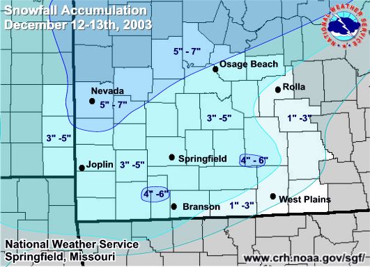
Below is the snowfall map from the event along with county by county measurements received from the event.
THE FOLLOWING ARE UNOFFICIAL STORM TOTAL SNOWFALL ACCUMULATIONS IN
INCHES FROM THE DECEMBER 12TH - 13TH 2003 WINTER STORM.
COUNTY SNOW ACCUMULATION (INCHES)
BARRY........4 TO 8
BARTON.......4 TO 6
BENTON.......4 TO 5
BOURBON......3 TO 5
CAMDEN.......3 TO 4
CEDAR........4 TO 6
CHEROKEE.....2 TO 5
CHRISTIAN....3 TO 5
CRAWFORD.....4 TO 6
DADE.........4 TO 5
DALLAS.......3 TO 4
DENT.........1 INCH
DOUGLAS......3 TO 5
GREENE.......3 TO 4
HICKORY......3 TO 5
HOWELL.......1 TO 2
JASPER.......3 TO 5
LACLEDE......3 TO 4
LAWRENCE.....3 TO 5
MARIES.......3 TO 5
MCDONALD.....2 TO 5
MILLER.......2 TO 4
MORGAN.......3 TO 5
NEWTON.......3 TO 4
OREGON.......TRACE TO 1 INCH
OZARK........2 TO 4
PHELPS.......1 TO 3
POLK.........3 TO 5
PULASKI......2 TO 4
TANEY........4 TO 5
TEXAS........2 TO 6
SHANNON......1 INCH
ST. CLAIR....3 TO 5
STONE........4 TO 6
WEBSTER......3 TO 6
WRIGHT.......3 TO 5
VERNON.......4 TO 6


 Weather Story
 Weather Map
 Local Radar
 Follow us on YouTube