 |
Tornado Outbreak - May 4th, 2003National Weather Service, Springfield, MO |
 |
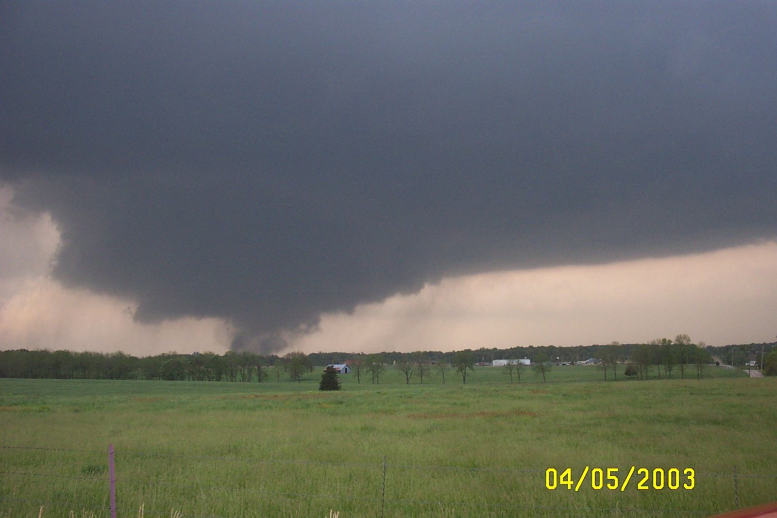
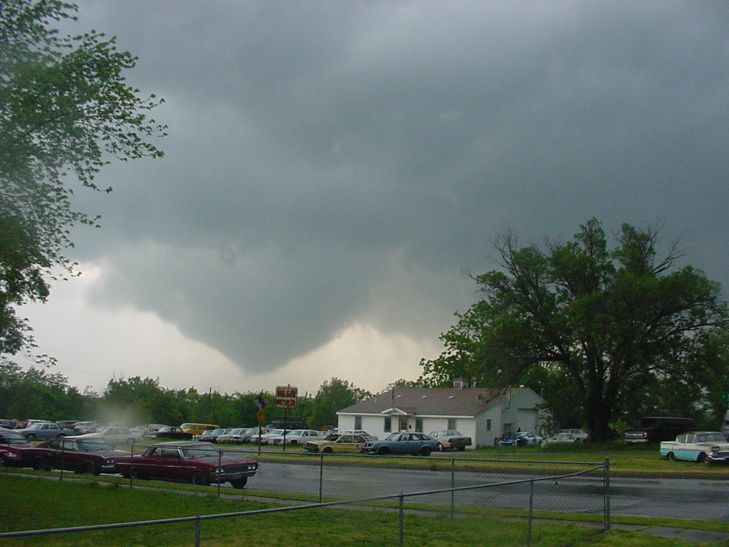
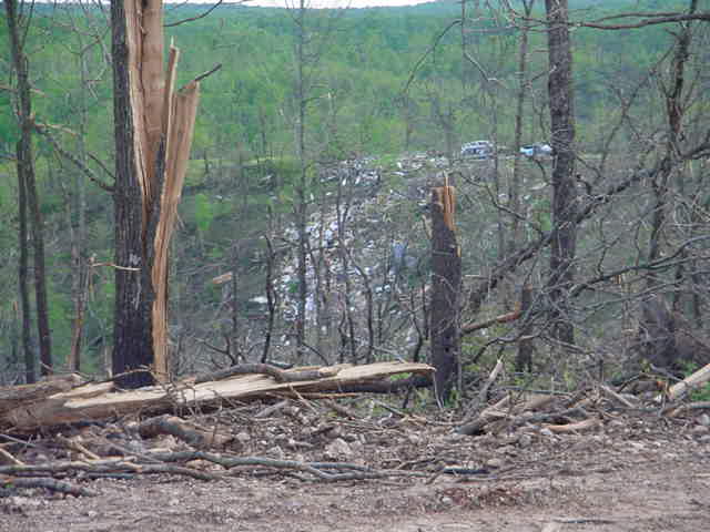
A major tornado outbreak hit the area Sunday afternoon and evening of May 4th, 2003. Supercell thunderstorms produced at least 15 tornadoes that resulted in extensive damage and 25 fatalities. Several of the tornadoes tracked long distances ranging from 15 to 80 miles. More than 3000 homes and businesses were damaged by the tornadoes. 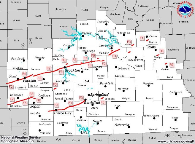
...The Ingredients for a Major Tornado Outbreak...
Meteorological conditions came together Sunday May 4th, 2003, to produce the major tornado outbreak across southeast Kansas and the Missouri Ozarks. Meteorological elements to produce a major severe weather event were in place and included a very moist and unstable airmass, strong lift and strong wind shear. The following information will provide a brief synopsis of these ingredients that produced the outbreak of destructive and deadly tornadoes.
 Sunday May 4th started off relatively cool and damp as the area remained north of a warm front that stretched across northern Oklahoma and Arkansas. A very moist and unstable airmass was located south of the front. The warm front lifted northeast during the day as a strong surface low developed and tracked across Kansas. Warmer air surged north during the day with temperatures rising into the 70s across southeast Kansas and far southwest Missouri by mid afternoon. Temperatures north of the warm front remained in the low to mid 60s.
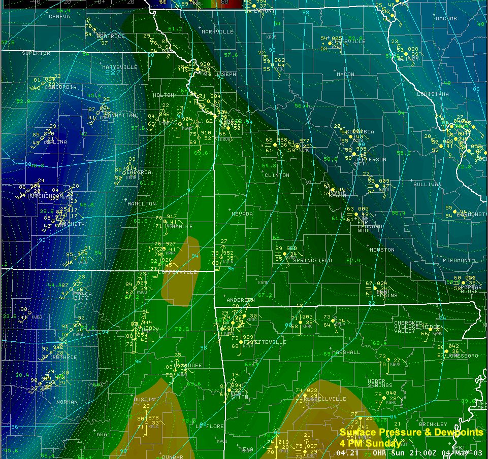 Meanwhile, a dry line surged east into eastern Kansas during the afternoon marking the boundary of very dry air to the west where dewpoints were in the 30s to the very moist air to the east where dewpoints were near 70 degrees.
|
Visible Satellite Radar Reflectivity
415 PM 422 PM
515 PM 457 PM
615 PM 607 PM
645 PM 657 PM
755 PM 753 PM
|
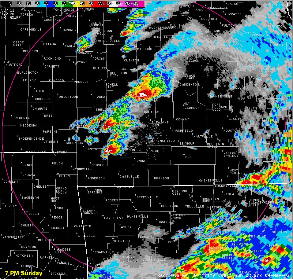
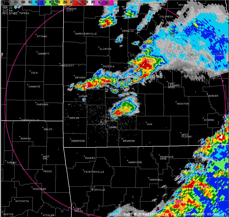
Thunderstorms developed rapidly around 3 PM across east central Kansas just ahead of the approaching surface low. Explosive thunderstorm development continued south along the dry line the remainder of the afternoon as mid level temperatures cooled ahead of the advancing upper level disturbance.
The storms quickly developed supercell characteristics across eastern Kansas. Three dominant supercells formed as the storms moved into southwest Missouri.
These supercells produced long tracked, destructive and deadly tornadoes. Once the supercells developed, they raced eastward at 45 mph. |
Lift
|
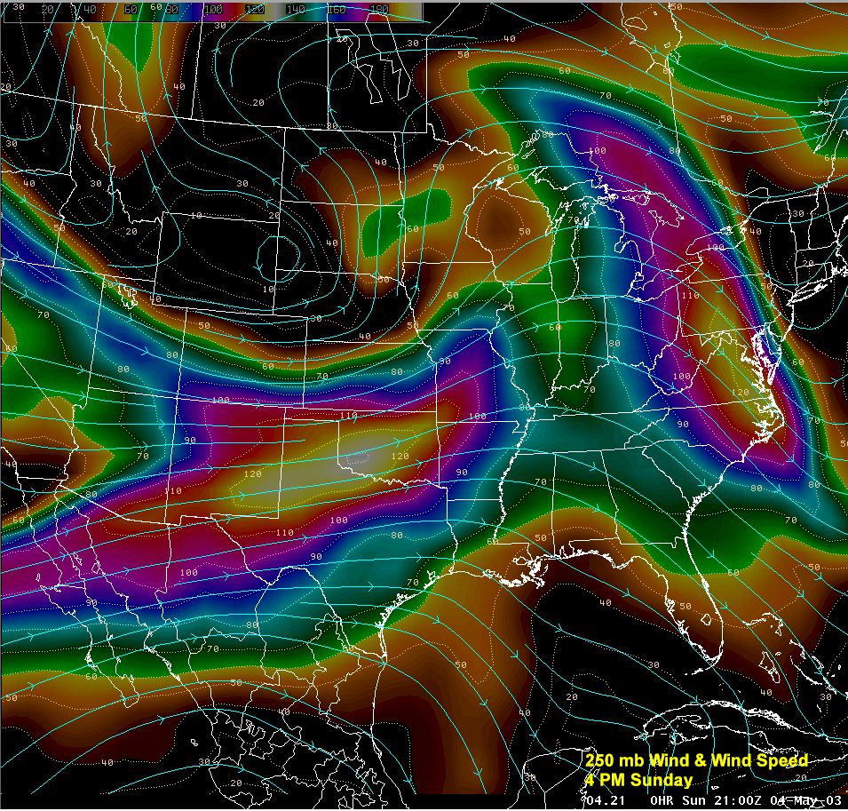
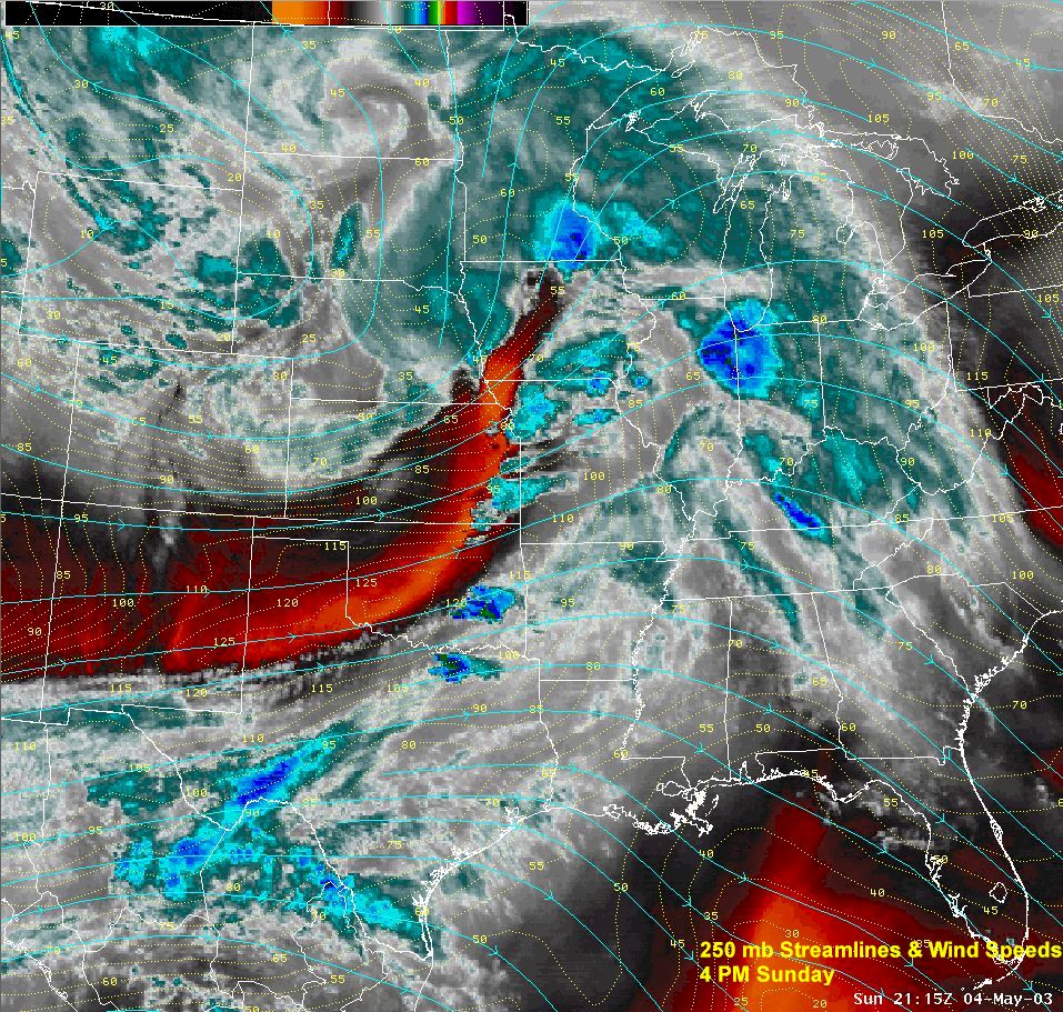
An intense upper level jet stream streaked across the southern Plains while a strong upper level disturbance lifted northeast from the central Rockies into central Plains. Upper level diffluence provided strong vertical lift.
This jet streak is noted by the drying (orange colors) on the water vapor imagery to the far right. Winds at 250 mb or ~35,000 ft. were ~ 125 kts, 75 kts at 500 mb or ~18000 ft. |
 
|
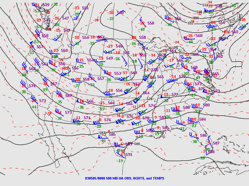 The 00z (7 PM) 500 mb analysis depicts the upper disturbance pushing northeast across the central Plains.
 The 00z ( 7 PM ) 250 mb analysis showed the strong jet stream streaking into the region.
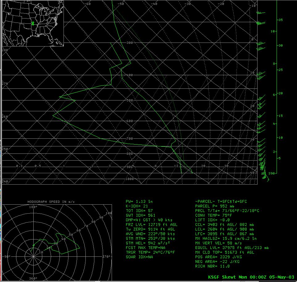
Instability
The upper air soundings below taken at the NWS office in Springfield show the evolution of the atmosphere between 1 and 7 PM. This data provides a profile of temperature, moisture, wind direction and speed from which instability and wind shear values can be calculated.
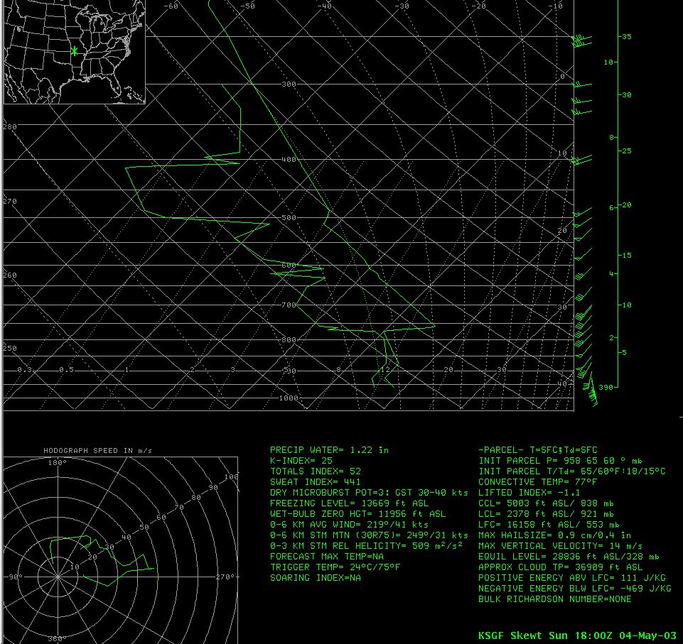

18z (1 PM) 20z (3 PM) 00z (7 PM)
A wedge of very unstable air developed between the warm front and approaching dry line. Lifted indices approached minus 10 and CAPES were near 4000 j/kg near the Kansas border by late afternoon.

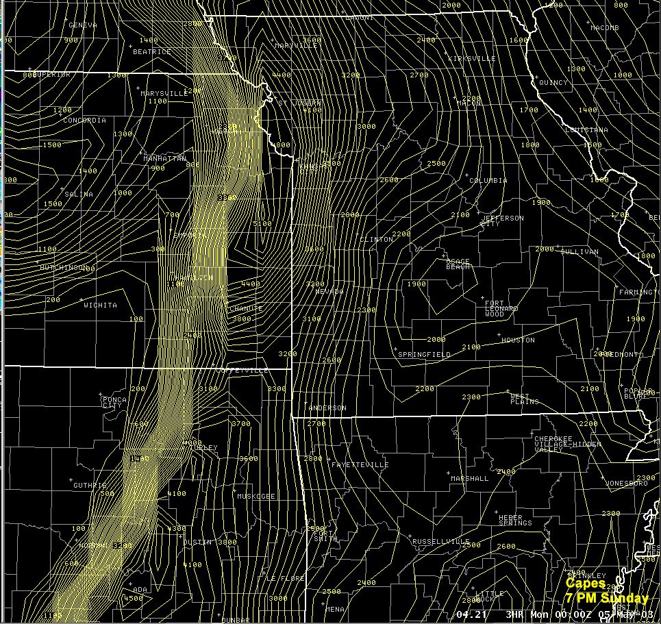
Lifted Index Cape
Wind shear
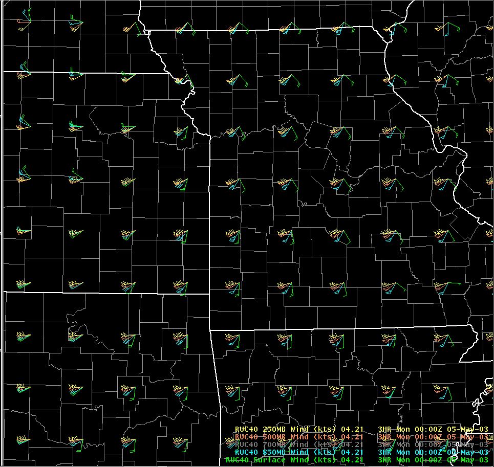
Wind shear is the change in wind direction and/or speed with height. Strong wind speed and directional shear was in place May 4th. Surface winds out of the southeast turned to the south then southwest through the mid and upper levels of the atmosphere. This turning with height combined with the strong instability supported the development of rotating thunderstorms called supercells.
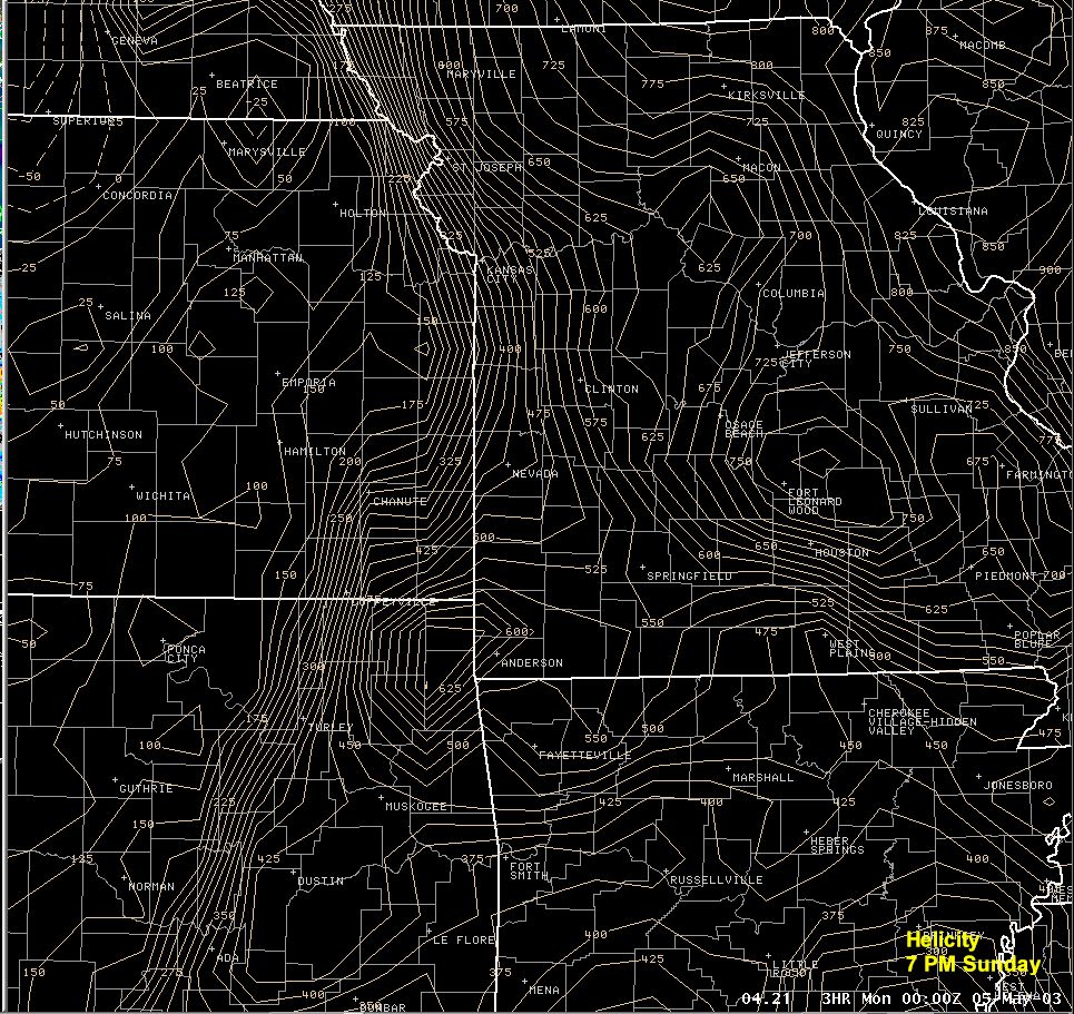
wind profile helicity
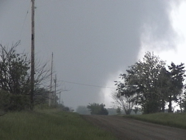
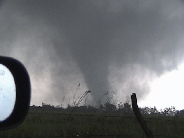
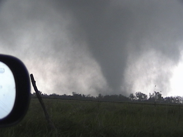
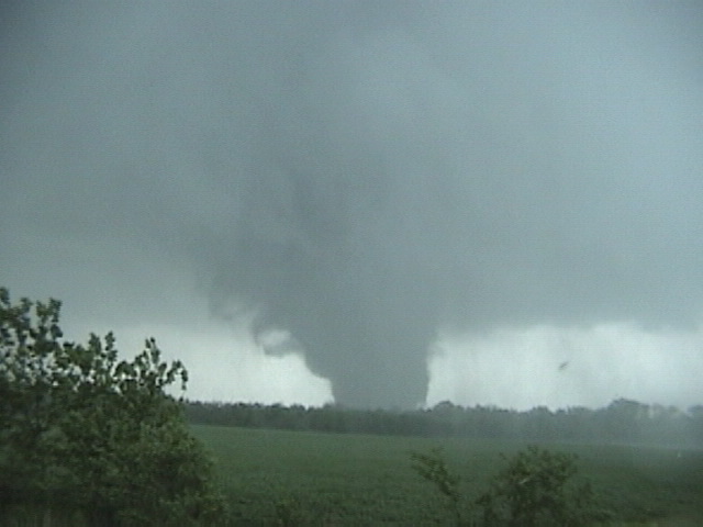
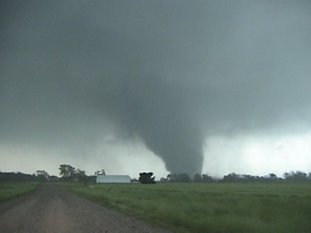
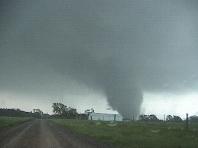
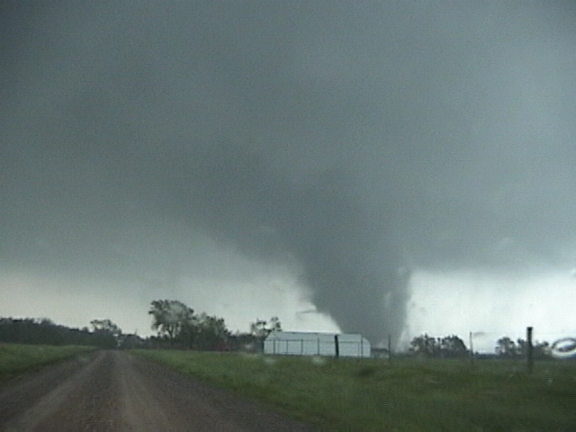
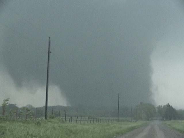
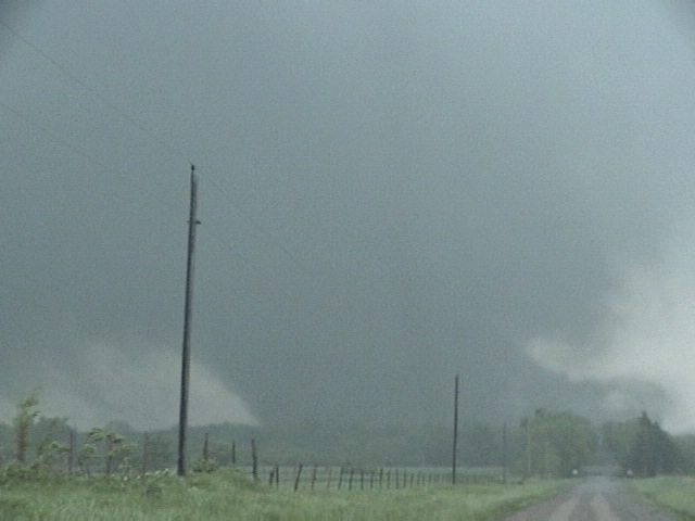
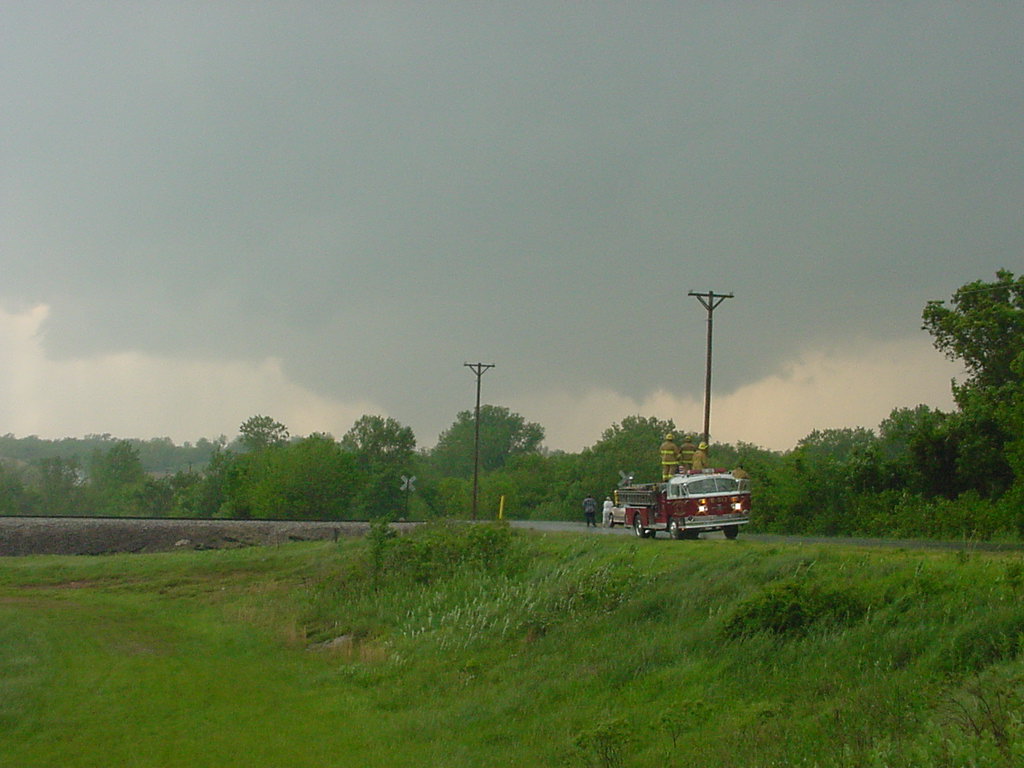
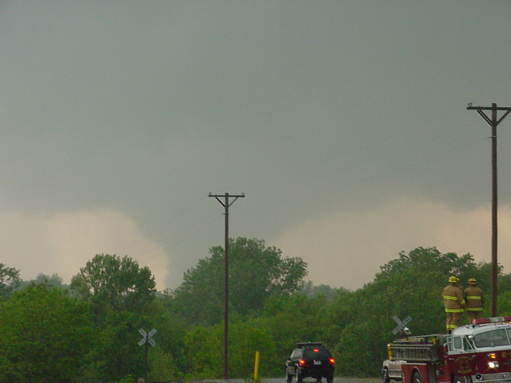
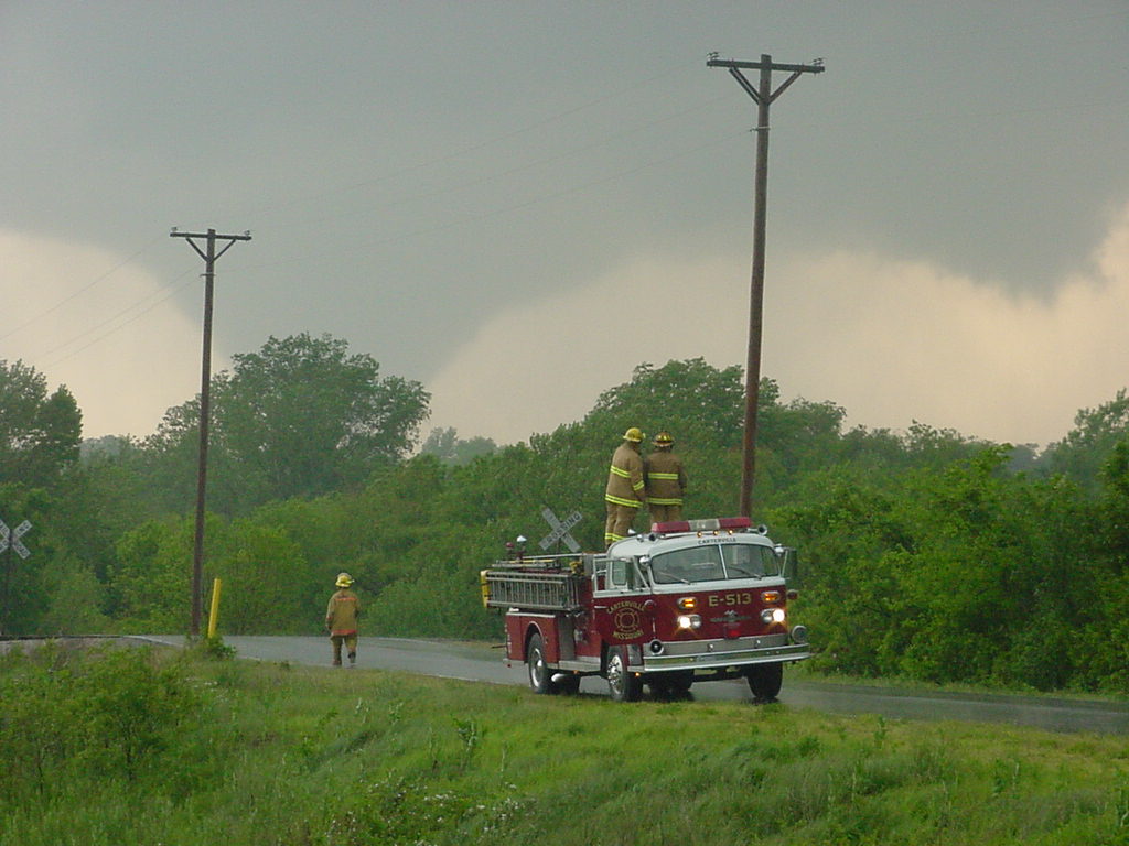
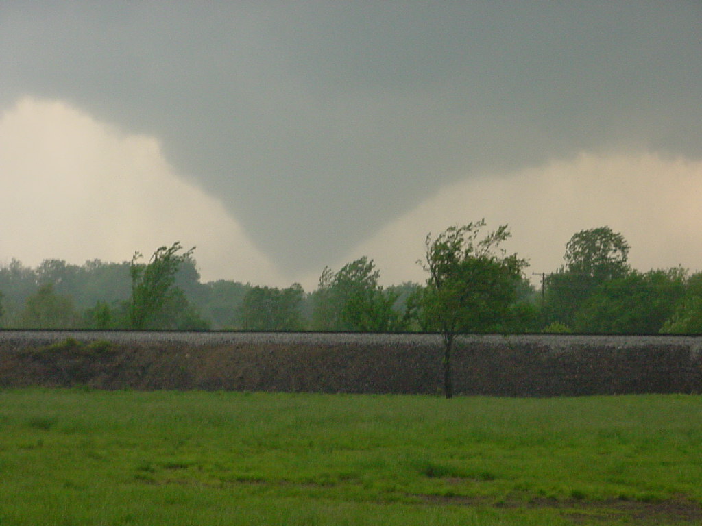
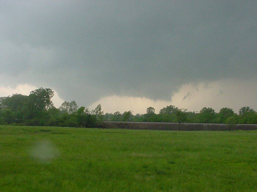
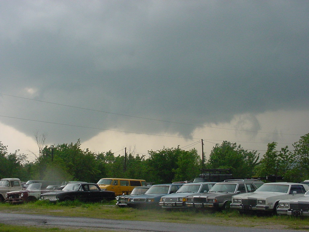
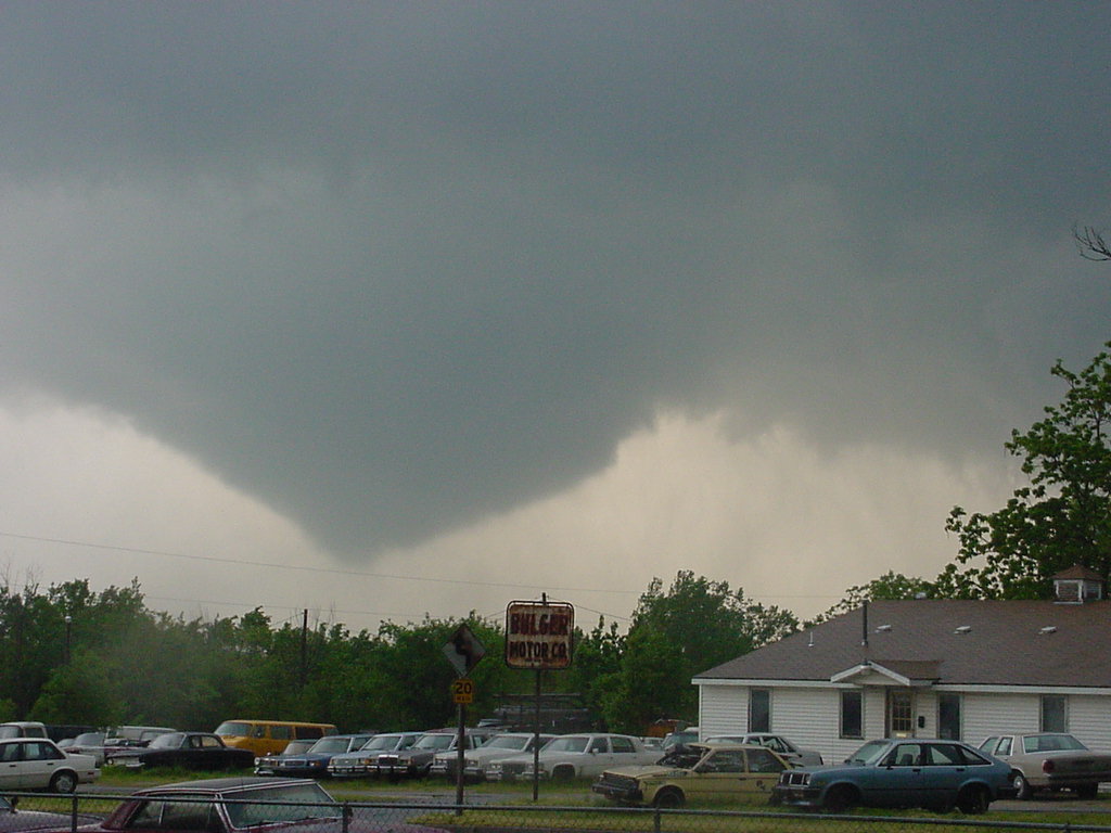
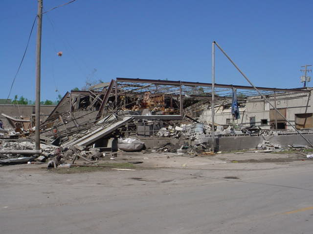
Pierce City - Battlefield Tornado and Damage Pictures
|
|
|
|
|
|
 Tornado near Aurora (Jason Politte) |
 Tornado near Aurora (James Taggart) |
 Clever |
 Battlefield | |
 Battlefield |
 Battlefield |
 Battlefield |

Girard (Chuck Robertson) |
Girard (Chuck Robertson) |
Girard (Chuck Robertson) |
Girard (Chuck Robertson) |
Girard (Chuck Robertson) |
Girard (Chuck Robertson) |
Girard (Chuck Robertson) |
Girard (Chuck Robertson) |
Girard (Chuck Robertson) |
Girard (Chuck Robertson) |

Girard (Chuck Robertson) |

Girard (Chuck Robertson) |

Girard (Chuck Robertson) |

Girard (Chuck Robertson) |
Girard (Chuck Robertson) |
Girard (Chuck Robertson) |
Carterville (Gregory Paul) |

Carterville (Gregory Paul) |
Carterville (Gregory Paul) |
Carterville (Gregory Paul) |
Carterville (Gregory Paul) |
Carterville (Gregory Paul) |
Carterville (Gregory Paul) |
Carterville (Gregory Paul) |

Carterville (Gregory Paul) |

Carl Junction (John Hacker) |

Carl Junction (John Hacker) |
Carterville (Gregory Paul) |
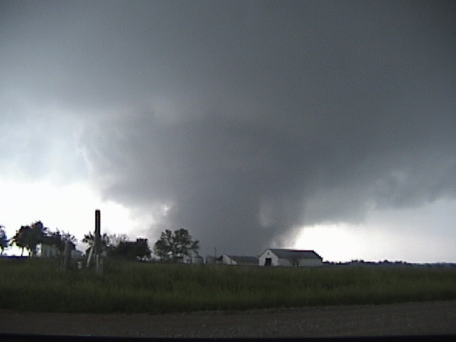
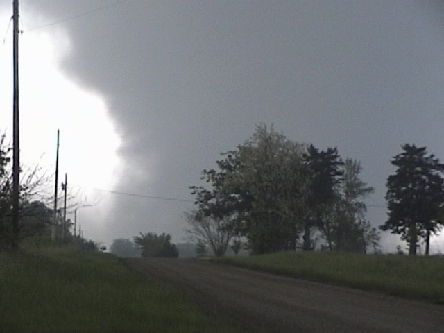
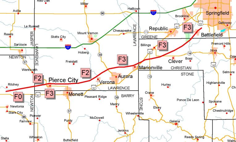
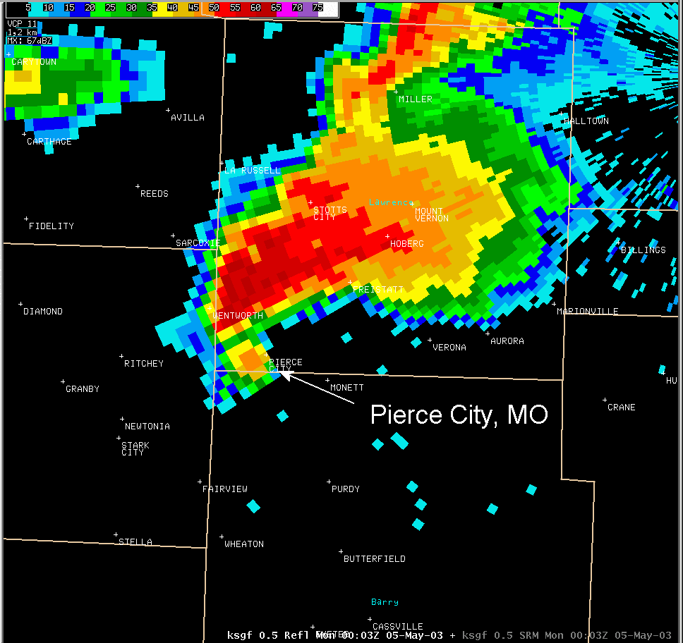
Tornado Path - Pierce City to Battlefield, MO
Sunday May 4th, 2003
F-scale: F3 at Pierce City, and From Northwest of Aurora to Battlefield
Path Length: ~45 miles Width: 1/4 to 1/2 mile Time: 645 - 800 p.m.
Radar Images
Pierce City
|
Reflectivity |
SRM |
Event Summary
This statement will focus on the Newton, Lawrence, Christian and southern Greene county track.
This nearly unbroken tornado track was about 45 miles long from extreme eastern Newton County east of Ritchey west of Pierce City to just northeast of Battlefield in Greene county. Several populated communities like Monett, Verona, Aurora and Marionville were spared the destructive power of this tornado because it moved just to the north of those towns.
Numerous reports of funnel clouds were reported by National Weather Service trained spotters and Chaser as the supercell moved east across McDonald and Newton Counties before the tornado touched down about three miles east of Ritchey and west of Pierce City.
At this point the tornado was rated as an F-0 topping trees and breaking limbs. Once the tornado reached just west of Pierce City it strengthened to an F-2 then F-3 rated tornado (158-206 mph) and moved quickly across the center part of town causing substantial and major damage to just about all buildings, brick and wood framed homes, and other structures. The tornado width was from one quarter mile to 600 yards wide but the debris path was over a mile wide.
Once the tornado moved east of Pierce City it was then rated an F-2 until it reached just north of Aurora and increased to an F-3. It continued the F-3 rating across the rest of its path until it lifted northeast of Battlefield. Along this path, the tornado width ranged from 200 yards to nearly one half mile wide. However, the debris path ranged from one quarter mile to one mile.
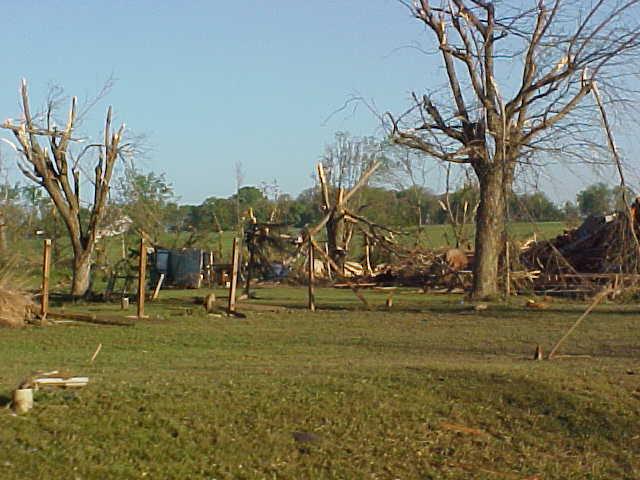
Along this path there were hundreds of large trees uprooted and snapped off, many power poles were snapped at their base that caused numerous power outages, especially in Monett. Also, numerous brick and wood framed homes, trailers, outbuilding, barns and other structures were severely damaged, completely destroyed or sustained minor damage.
Just southwest of Springfield in the community of Battlefield, many residential homes, the fire department, a church, and several small businesses were damaged. In several areas along the tornado path, some trees were stripped of all bark.
Along this very destructive path the following confirmed deaths were reported: Pierce City 1, three miles north of Monett 2, north of Marionville 2, one mile north of Clever 1, and Battlefield 1. There were numerous injuries.
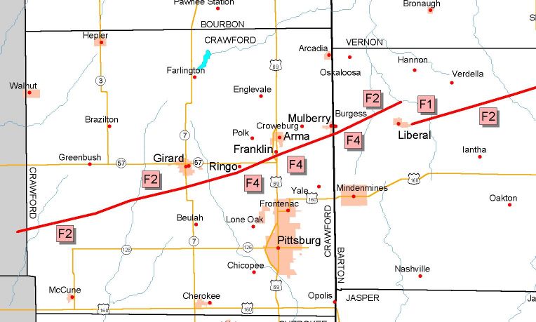
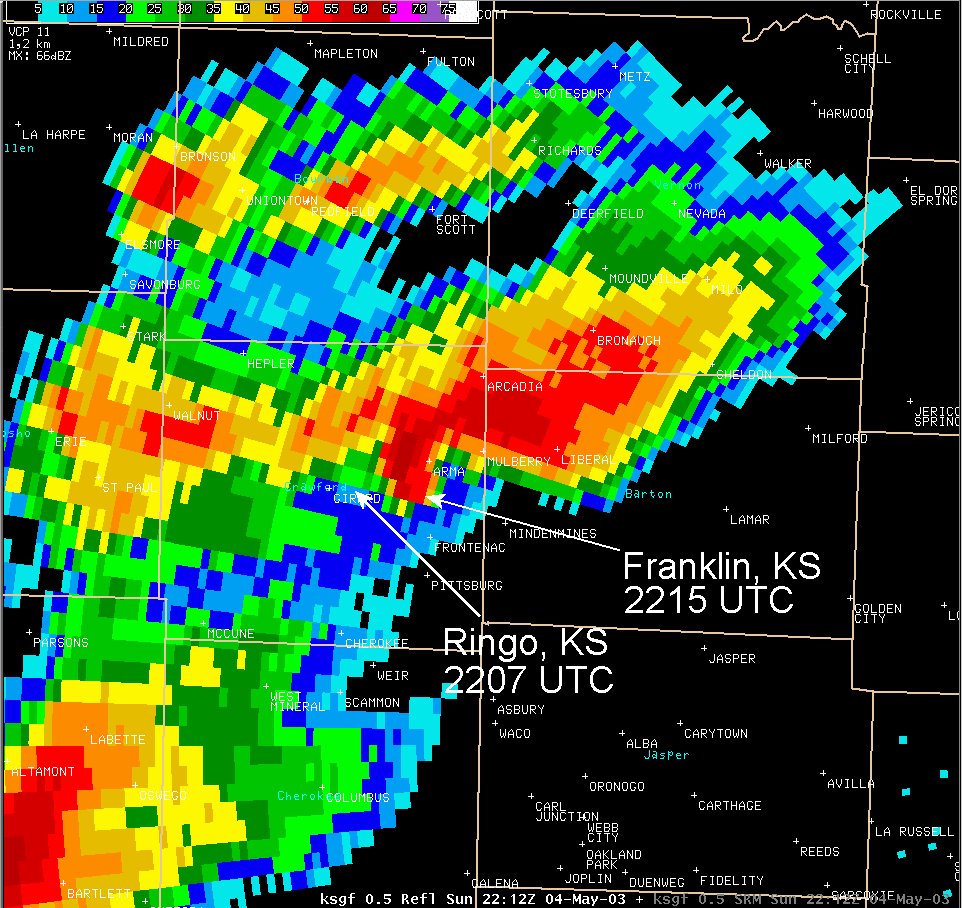
Tornado Path - Girard Ks. to Liberal Mo.
Sunday May 4th, 2003
F-Scale: F4 From Just Southwest of Ringo, Through Franklin, to North of Liberal, MO
Path Length: ~35 miles Width: 1/4 to 1/2 mile Time: ~432 - 532 p.m.
|
Reflectivity |
SRM |
Event Summary
Here’s the final report for the Crawford County Kansas to Barton County Missouri tornado track. First, a high end F-4 (207 - 260 MPH) struck the communities of Ringo and Franklin in eastern Crawford County, and continued to just northwest of Liberal, MO. As fate would have it, the tornado track went between several populated areas sparing them from the destructive damage that befell Ringo and Franklin.
The tornado track extended west across Neosho County Kansas but we picked up the track (by air) beginning about four miles west of South Mound in Neosho County. Here it appeared to be skipping, and topping and uprooting trees. This portion of the tornado track in Neosho County was rated by the Wichita National Weather Service Office.
From the Neosho and Crawford County line, or six miles north northwest of McCune F-2, damage was observed as the tornado moved east northeast until it reached about two miles south of Girard were the tornado intensified. Til this point, the tornado width was about 250 yards wide but increased to about one quarter mile wide about three miles west southwest of the community of Ringo. At this point we observed scouring of the field below and the tornado was rated an F-4 based on the type and scope of structural damage and very heavy objects such as vehicles being tossed several hundred feet away from their original position. The tornado continued its east northeast track as an F-4 as it reached the community of Franklin and caused severe and total devastation to numerous homes and buildings, and tossed heavy objects and vehicles several hundred feet. The tornado width continued over one quarter mile wide across the F-4 track.
It remained an F-4 east of Franklin to just south of Mulberry, KS. As it crossed into Missouri the tornado remained an intense high end F-4 rated tornado until it reached north of Liberal, Missouri, in Barton County, then an F-2 and F-1 as it lifted and became rain wrapped. This feature was observed by a storm chaser who also witnessed the formation of the northeast Barton, Cedar and Polk County tornado described in one of the other reports.
The length of this tornado was about 35 miles long and like the other long track tornadoes from May 4, 2003, it uprooted or snapped off numerous trees and poles, destroyed or severely/totally damaged many homes, barns and outbuildings, not to mention uprooting many large over 50 to 75 year old hardwood trees. Four people were killed along this tornado track. one of the other tragic occurrence from all these tornados was the death of farm animals and pets.
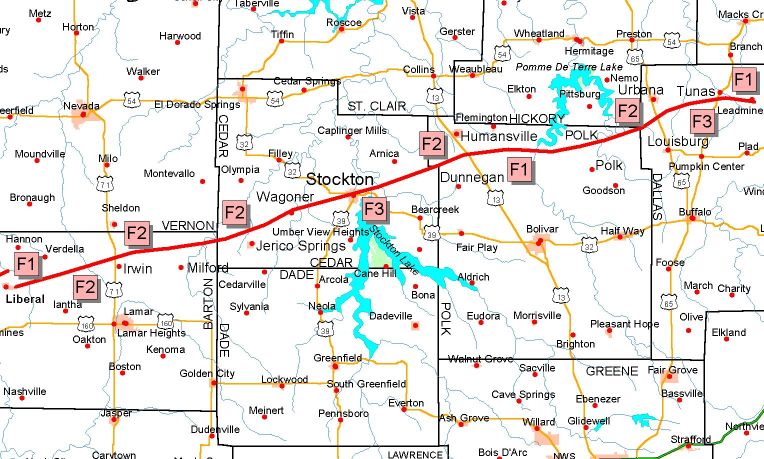
Tornado Path - Cedar, Polk and Dallas counties of Southwest Mo. including the city of Stockton
Sunday May 4th, 2003
F-Scale: F3 at Stockton
Path Length: ~83 miles long Width: 1/4 to 1/2 mile Time: 531 - 742 p.m.
Radar Images
Stockton
|
Reflectivity |
SRM |
Event Summary
This summary is for the tornado that moved from northeast Barton County across Cedar and Polk Counties into Dallas County, including the City of Stockton.
The tornado initially touched down just east of Liberal, MO in Barton County as an F-1. The tornado produced F1 damage to some out buildings and uprooted numerous trees as it moved across the northeastern portion of the county. The storm then entered Cedar county near the Vernon-Barton-Cedar County line northwest of Jerico Springs. The tornado passed to the north of Jerico Springs staying in mainly rural areas. The storm caused roof damage to several homes in the area and destroyed at least one mobile home in this area prompting an F-2 rating.
The storm continued to down power lines and cause tree damage until it reached the intersection of Highway Z and County Road 825. Here the tornado completely destroyed a frame house and two out buildings sweeping debris across the road. This house did appear to have the walls anchored to the foundation warranting an F3 rating. From there, the tornado entered the town of Stockton and passed just to the north of the county courthouse through the city park. At this point the tornado was estimated to be between one-half and three-quarters of a mile wide. Two fatalities occurred in downtown Stockton.
Damage within the town of Stockton was extensive with numerous buildings destroyed or damaged within the downtown area. Two cars from a local dealership were also blown approximately one block to the northeast. Survey of the most extensively damaged buildings was indicative of a high F-3 rating. The tornado proceeded east-northeast of Stockton for about three miles where a two-story frame house had the roof and approximately two-thirds of the upper story destroyed. In addition, a van had been blown onto the road and a pickup truck was flipped over in the ditch also warranting a high F-3 rating.
From this point until the tornado exited the county about two miles northwest of Dunnegan, it remained over mainly rural areas causing damage to trees and power lines. When the storm did come in contact with homes, damage to roofs and exterior walls was noted. A mobile home was blown off its foundation and destroyed prompting an F-2 rating within this area.
In Polk County, two miles north of Dunnegan, a dairy farm sustained high F-1 damage, with trees sheared off and barn roofs blown off. It appeared at this point the tornado briefly became elevated since the tops of trees right up against a well constructed house were sheared off yet the roof of the house remained intact with little damage. Four miles southeast of Humansville, a frame house sustained F-2 damage losing a roof and at least two outside walls. The tornado path remained unbroken through northeast Polk County. The damage path was wide, about 300 to 400 yards from one mile south of Rondo to the Mohawk Corner area. High F-1 damage was observed about one-half mile west of Mohawk Corner where one exterior wall was destroyed on a frame house and several barns were destroyed.
The storm initially entered Dallas county near the Hickory-Polk-Dallas County line southwest of Urbana. At this point, the storm appears to be two tornados running parallel to each other about a quarter of a mile apart. The northern storm was about 200-300 yards wide while the southern storm was about 100 yards wide. Two fatalities occurred in theTunas area.
From the entry point until it reached U.S. Highway 65, damage was confined to the tops of trees being snapped or uprooted. As the northern storm crossed Highway 65, it destroyed three mobile homes throwing debris northeastward across the road warranting an F-2 rating. Both tornados remained over rural areas producing tree damage. The southern storm also took the roof off an equipment shed. The southern storm is rated F-1 between Highway 65 and County Road U while the northern storm remains an F-2.
The southern storm appeared to have dissipated near County Road U. As the northern storm crossed County Road U, it destroyed a mobile home. In addition, the trees across the road were stripped of leaves and many small branches. The tornado then began taking a more eastward track running parallel to Judges Branch Road with a width of about one-quarter mile. Two frame homes along this road sustained damage to the roof and exterior walls and three mobile homes were completely destroyed.
The tornado next encountered two frame homes as it crossed State Highway 73. The brick home had most of the outside walls destroyed while the frame home across the road had the outside walls destroyed on the south and west sides. Also noted at this point was that a compact car was picked up and flipped across the road. Based on this damage, the storm was rated an F-3.
The storm then continued for approximately three miles crossing County Road T south of Lead Mine. Here the tornado caused some roof damage to one home for an F-1 rating at this point. The tornado appears to have dissipated about a half mile east of this point just inside the Lead Mine Conservation area. The total path length of the tornado path was about 83 miles long.
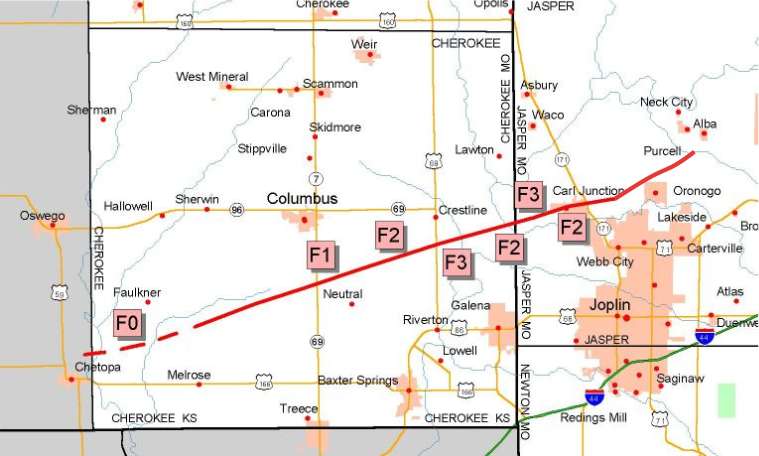
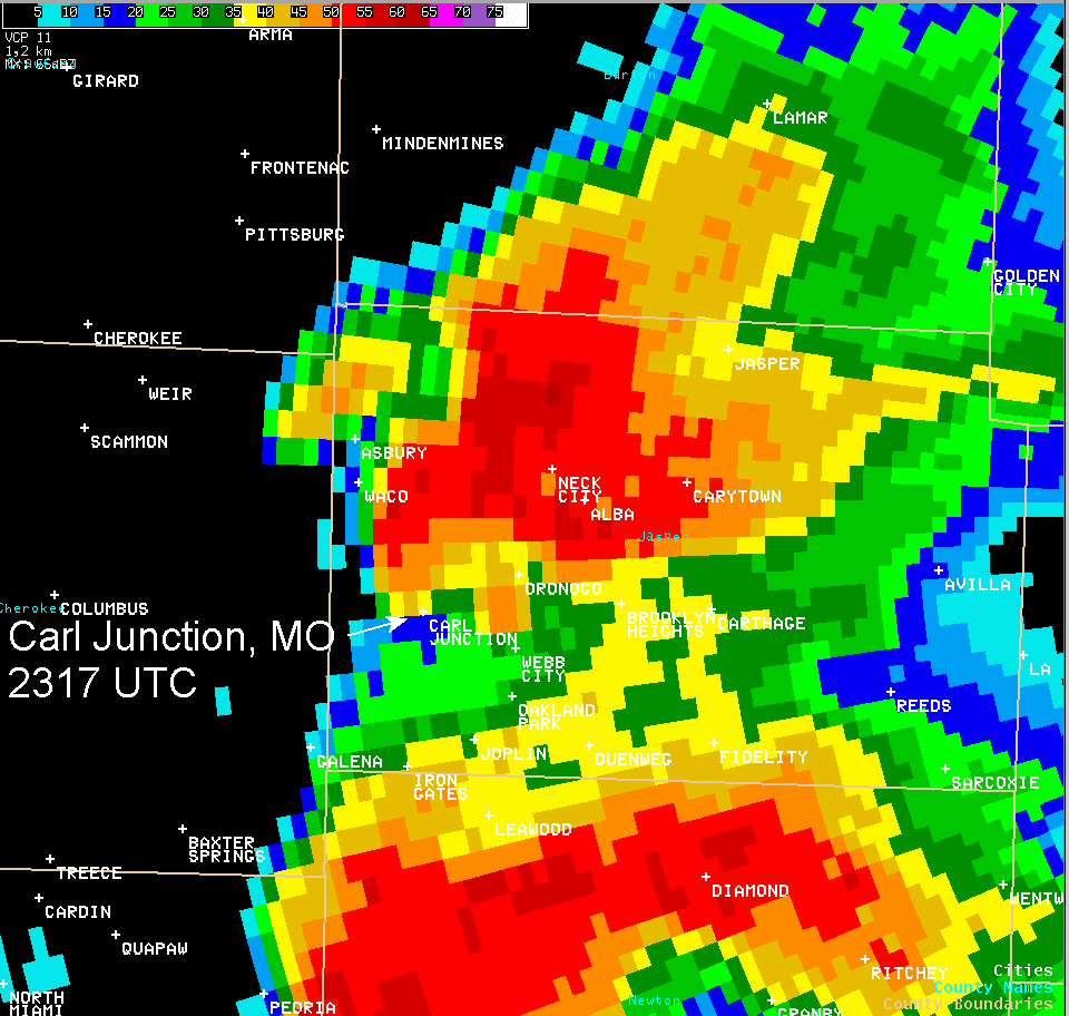
Tornado Path - Cherokee County KS to Carl Junction, Mo.
Sunday May 4th, 2003
F-Scale: F3 From South of Quaker, KS to near Alba, MO
Length: ~33 miles Width: 1/4 to 1/2 mile Time: ~530 - 624 p.m.
|
Reflectivity |
SRM |
Event Summary
Here is an update for the tornado that moved across southern Cherokee County, Kansas and into the Carl Junction area in Jasper County of southwest Missouri. This tornado track extended west into Labette County north of Chetopa but that portion of the survey was completed by the Wichita, Kansas, National Weather Service Office.
After initially touching down southwest of Bartlett in Labette County, the Cherokee - Jasper tornado crossed the Labette/Cherokee county border southwest of Faulkner. For the next 54 minutes, tornadoes from this storm intermittently touched down, with the greatest damage noted south of Columbus, north of Galena, and in the Smithville and Carl Junction areas. All together, the storm resulted in the deaths of three people in Cherokee County, and two people in Jasper County.
In Cherokee County, the tornado moved east northeast and passed north of Melrose where it was rated as an F-0 (40 - 72 MPH) to just west of Highway 69/7 and rated as an F-2 (113 - 157 MPH) until it reached just northeast of Neutral and rated an F-1 (73 - 112 MPH). It was again rated as an F-2 just south of Quaker and rated an F-3 (158 - 206 MPH) just southwest of Badger. After passing south of Badger it was rated an F-2 until it reached just west of Smithfield where it was rated as an F-3 through the community of Smithville and just north of Stringtown until it reached the west portion of Carl Junction. Through most of Carl Junction it was rated a high F-2. After exiting Carl Junction to the east and across Highway 171 it was rated an F-2 skipping until it reached just northwest of Oronogo and lifted near the intersection of Highways 96 and 43.
While moving across this deadly and destructive path, the tornado severely damaged numerous modular and wood framed homes, barns and outbuildings. Hundreds of trees were uprooted or snapped off as were power poles. The tornado width ranged from 200 to 500 yards. Debris from many of the homes and outbuildings was located over one half mile to a mile away.
Perhaps the most significant damage occurred to an A frame house that was positioned perpendicular to the tornado, and to another wood frame home where the entire contents of the home were thrown well away from the foundation. Two deaths occurred at this second residence. Probably the most overall concentrated damage was to the community of Smithville and Carl Junction.
Here the tornado damaged several homes and businesses. Damage to brick buildings downtown and a brick home just east of Highway 171 resulted in an F-2 damage rating. Intermittent tree damage was then noted between Carl Junction and the intersection of Highways 96 and 43, or just northwest of Oronogo.
One notable miracle from this event was a farm home with a mother and three children that was spared the full brunt of the tornado. The home was located about seven miles northeast of Melrose were the tornado was rated an F-2. The tornado was on a direct path of the home but only damaged the roof and windows. However, several large trees right next the house and in back were uprooted or snapped off indicating the power of the tornado.
A second tornado was reported by residents between Carl Junction and the Joplin Airport. No damage was observed with this storm and it was rated as an F-0. Yet a third funnel cloud was reported but did not touch down. At one time, all three rotating vortices were observed.Tornado Path - Camden County Mo.
Sunday May 4th, 2003
F-Scale: F3 North of Decaturville
Path Length: ~15 miles Width: 100 yards to 1/4 mile Time: 736 - 808 p.m.
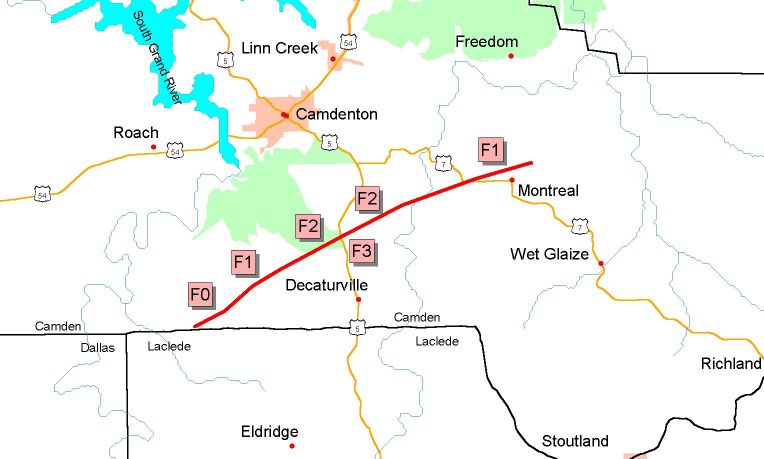
Event Summary
This summary is for the tornado which moved south of Camdenton, MO before lifting just north of Montreal in Camden County. The storm was rated an F-3 north of Decaturville and resulted in the deaths of three individuals in residences along Highway 5 the southeast of Camdenton.
The tornadic storm, called a supercell, earlier produced a deadly tornado in northern Dallas County then moved across the northwest corner of Laclede County before again producing a tornado to the southwest of Camdenton near Tunnel Dam Road. The tornado tracked east northeast, heavily damaging more than a dozen additional homes.
Perhaps the most significant damage was to a wood frame home along Highway 5 approximately five miles southeast of Camdenton. Despite having roof rafters bolted to the walls and the walls bolted to the foundation (a few of which were pulled out of the concrete), this house was swept free a short distance from the foundation. At another location, damage was reported to have been swept against the flow of the storm some 100 - 200 yards. Other significant damage was observed on Spencer Creek Road and off High Point Road. The combined observations of these reports resulted in the National Weather Service to rate the tornado at the high end of an F-3, indicating winds approaching 200 mph.
The total path length of the tornado was approximately 15 miles.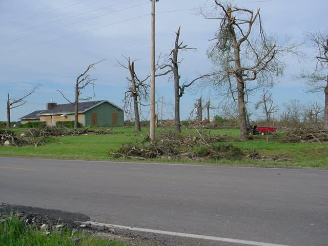 |
 |
 |


 Weather Story
 Weather Map
 Local Radar
 Follow us on YouTube