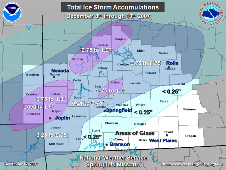
...Ice Storm Event Summary December 8th through 10th...
The second major ice storm of the year impacted much of the Missouri Ozarks and southeast Kansas from Saturday December 8th to Monday December 10th.
Damaging ice accumulations of three quarters of an inch to one and a half inches occurred from the Joplin Missouri and Pittsburg Kansas areas northeast to the Osceola and Versailles areas. These accumulations downed numerous trees...tree branches and power lines resulting in widespread power outages.
Lesser accumulations of one quarter to one half of an inch with locally higher amounts near three quarters of an inch fell along the interstate 44 corridor. This resulted in downed tree branches and scattered power outages.
Ice Storm Accumulation County Summary...
County Ice Accumulation
Kansas:
Bourbon 0.25 to 0.50
Crawford 0.50 to 1.50
Cherokee 0.75 to 1.50
Missouri:
Vernon 0.50 to 1.00
Barton 0.75 to 1.50
Jasper 0.75 to 1.50
Newton 0.25 to 0.75
McDonald 0.25 to 0.50
St. Clair 0.50 to 1.00
Cedar 0.50 to 1.00
Dade 0.25 to 0.75
Lawrence 0.25 to 0.50
Barry 0.10 to 0.50
Stone 0.10 to 0.25
Christian 0.10 to 0.25
Greene 0.25 to 0.75
Polk 0.25 to 0.75
Hickory 0.50 to 1.00
Benton 0.50 to 1.00
Morgan 0.75 to 1.00
Camden 0.25 to 0.75
Dallas 0.50 to 1.00
Webster 0.10 to 0.50
Taney 0.10 or less
Maries 0.25 to 0.75
Laclede 0.25 to 0.75
Wright 0.10 to 0.25
Douglas 0.10 to 0.25
Ozark none
Howell none
Texas 0.10 to 0.25
Pulaski 0.25 TO 0.75
Phelps 0.25 TO 0.75
Dent 0.25 TO 0.50
Shannon 0.10 OR LESS
Oregon NONE
The National Weather Service would like to thank emergency management and law enforcement officials, SKYWARN and volunteer observers and local media for their efforts and cooperation during this ice storm.


 Weather Story
 Weather Map
 Local Radar
 Follow us on YouTube