Overview
|
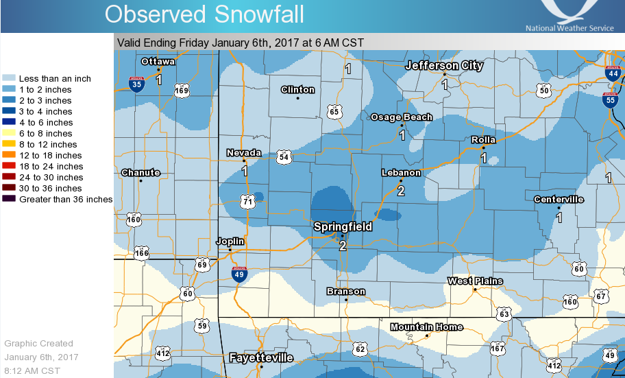
Upper level jet energy combined with a little bit of moisture and very cold temperatures to produce a few bands of snow from the early morning hours of January 5th, 2017 until the early afternoon hours. Because of the colder temperatures, snow ratios were between around 15 to 1 and 20 to 1. So despite the low precipitation totals across the area, most locations received between a half inch to inch of snow, with a main area cutting through the center portion of our forecast area that had between 1 to 2 inches. A couple of spotty localized areas received between 2.8 and 3 inches. |
 Snow Map |
Snow/Ice
...Snowfall Reports for January 5th...

Location                     Amount     Provider

...Kansas...

...Bourbon County...
Devon                        0.5 in     COCORAHS

...Crawford County...
Pittsburg                    0.8 in     COOP
1 NW Opolis                  0.8 in
Cherokee                     0.5 in     COCORAHS

...Missouri...

...Barton County...
1 NNE Irwin                  2.0 in

...Benton County...
Cole Camp                    0.5 in
Warsaw                       0.5 in

...Camden County...
1 ENE Camdenton              2.0 in

...Cedar County...
El Dorado Springs            3.0 in
Umber View Heights           1.9 in     COCORAHS
Stockton 2.5 NNE             1.5 in     COCORAHS


...Christian County...
2 SW Nixa                    0.6 in     COCORAHS

...Dade County...
Lockwood                     2.0 in     COOP
Greenfield                   1.5 in

...Dallas County...
3 S Buffalo                  1.7 in     COOP
2 N Buffalo                  1.5 in
3 NE Foose                   1.5 in

...Dent County...
1 NW Salem                   1.1 in     COCORAHS
1 E Lake Spring              0.5 in     COCORAHS

...Douglas County...
Ava                          0.5 in

...Greene County...
Strafford                    3.0 in
3 WSW Bassville              2.2 in     COCORAHS
3 WNW Ebenezer               2.1 in     COCORAHS
2 E Sacville                 2.0 in
1 N Fair Grove               2.0 in
6 S Springfield              2.0 in
3 SW Springfield             1.8 in
1 W Galloway                 1.5 in     COCORAHS
Springfield, Mo              1.5 in     NWS
3 ENE Springfield            1.4 in
3 E Battlefield              1.1 in     COCORAHS
Republic                     1.0 in
Ash Grove                    1.0 in     COOP

...Hickory County...
1 S Hermitage                1.5 in
Black River                  1.5 in     COOP

...Jasper County...
Joplin                       1.0 in
3 SW Carl Junction           0.3 in     COCORAHS

...Laclede County...
Lebanon 0.6 N                1.5 in     COCORAHS

...Lawrence County...
Mount Vernon                 1.0 in
3 ENE Red Oak                0.3 in     COCORAHS

...Newton County...
Shoal Creek Estate           0.5 in     COCORAHS
Stark City 5.5 ENE           0.1 in     COCORAHS
4 NNW Pioneer                0.1 in

...Phelps County...
3 SSW Rolla                  1.7 in     COCORAHS
Rolla                        1.5 in     COOP
Northwye                     1.5 in     COCORAHS
Saint James                  1.0 in     COCORAHS
4 NNW Lecoma                 0.8 in     COCORAHS

...Polk County...
3 E Flemington               2.0 in
Morrisville                  1.5 in     COOP
Dunnegan 2.4 NNW             1.4 in     COCORAHS
1 SSW Bolivar                1.3 in
1 E Fair Play                1.0 in     COCORAHS


...Pulaski County...
4 NW Waynesville             1.0 in     COCORAHS

...Shannon County...
3 ESE Pine Crest             2.3 in     COCORAHS
Eminence 1n                  1.5 in     COOP
Ranger Station-current River 1.1 in     COOP
Round Spring                 1.0 in
Winona 3 SW                  0.7 in     COOP

...St. Clair County...
2 WNW Gerster                1.0 in     COCORAHS
Osceola                      1.0 in
Appleton City                0.8 in

...Taney County...
Forsyth                      0.2 in     COCORAHS
Branson Airport              0.1 in     COOP
2 NE Ridgedale               0.1 in

...Texas County...
2 WNW Yukon                  2.0 in     COCORAHS
Houston                      1.5 in     COOP

...Vernon County...
3 WNW Nevada                 0.8 in
Nevada 0.2 W                 0.7 in     COCORAHS

...Webster County...
3 NNE Northview              2.8 in
Fordland                     2.5 in
Marshfield                   2.1 in     COOP

...Wright County...
3 N Mansfield                3.0 in
Grovespring                  3.0 in
1 SSW Mountain Grove         2.5 in
Mansfield                    2.0 in     COOP
3 SSW Mansfield              1.5 in

Observations are collected from a variety of sources with varying
equipment and exposures. Not all data listed are considered official.

$$
Radar:

 |
Media use of NWS Web News Stories is encouraged! Please acknowledge the NWS as the source of any news information accessed from this site. |
|


 Weather Story
 Weather Map
 Local Radar
 Follow us on YouTube