National Weather Service United States Department of Commerce

Strong to Severe Thunderstorms May Bring Excessive Rainfall to the Southern U.S. Saturday

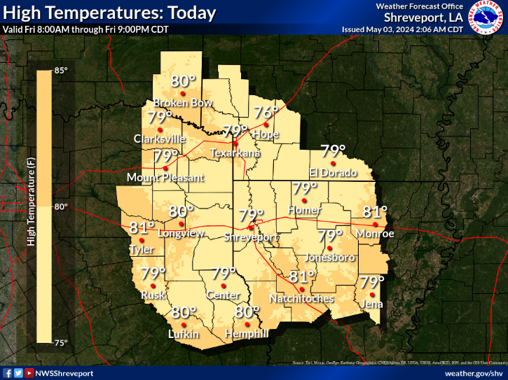
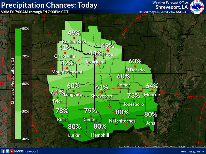
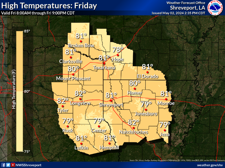
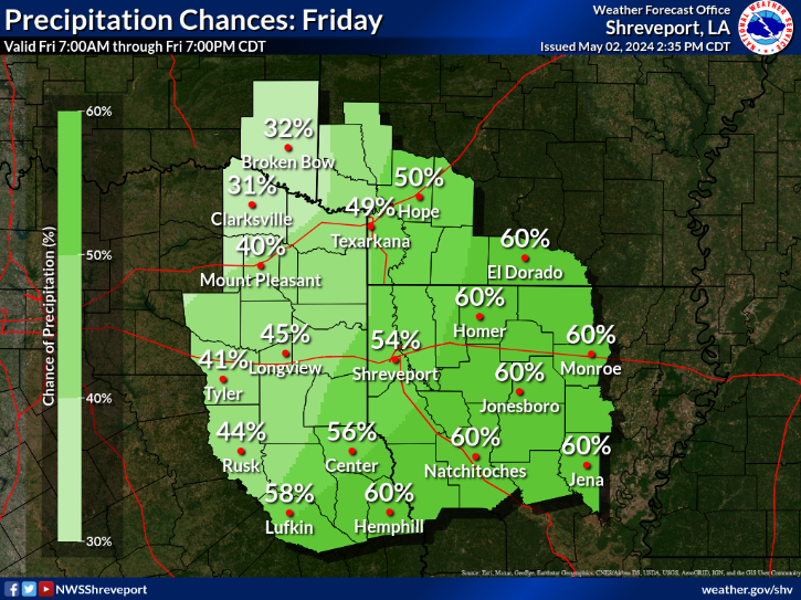
Marginally severe thunderstorms capable of strong wind gusts and hail will be possible Saturday across much of central Texas, and during the afternoon across parts of the Southeast U.S. Heavy rain from thunderstorms may bring isolated flash and urban flooding, along with new and renewed rises on rivers and streams throughout East Texas and the lower Mississippi Valley. Read More >

Click a location below for detailed forecast.

Last Map Update: Fri, Apr. 19, 2024 at 9:10:14 pm CDT

National Weather Service Tulsa, OKNational Weather Service Little Rock, ARNational Weather Service Memphis, TN
National Weather Service Fort Worth/Dallas, TXZoom
Out

National Weather Service Jackson, Mississippi
National Weather Service Houston/Galveston, TXNational Weather Service Lake Charles, LANational Weather Service New Orleans/Baton Rouge


Look for widespread rainfall amounts of one to three inches with isolated higher amounts possible through Sunday. This may result in additional rises on area waterways as well as flooding of flood prone and poor drainage areas.
Cooler temperatures across the region for many as lows will range from the upper 40s across the north to low 60s across the south.
Multiple rounds of heavy rainfall and widespread thunderstorms will move across the region for all of Saturday.
Here are the daily climate data for selected cities in the Four State Area.

Latest Text Product Selector (Selected product opens in a new window)


 Current Weather Observations...
Location Time
(CDT)
Weather Vsby.
(SM)
Temp.
(ºF)
Dewpt.
(ºF)
Hum.
(%)
Wind
(mph)
Wind Chill / Heat Index
(ºF)
Pres.
(in)
De Queen AR20:53Overcast10615580ENE 5-30.08
El Dorado AR20:53Overcast10585590-30.09
Henderson TX20:55Mist5696688NE 5-30.05
Idabel OK20:55Overcast106060100E 9-30.10
Longview TX20:53Overcast10676387NE 6-30.03
Lufkin TX20:53Partly Cloudy10757290N 5-29.99
Monroe LA20:53Overcast10646086NE 10-30.07
Mount Pleasant TX20:55Overcast762NE 5-30.07
Nacogdoches TX20:56Overcast87070100CALM-30.02
Natchitoches LA20:55Overcast10717096NE 9-30.01
Shreveport LA (Regional Airport)20:56Overcast8666082NNE 12-30.04
Shreveport LA (Downtown Airport)20:52Overcast10645982NE 8-30.05
Texarkana AR20:53Light Rain8605583NE 8-30.10
Tyler TX20:53Haze3686383NE 8-30.03


Submit Storm Report Local Shreveport Radar Local Hazards Forecast Maps Graphical Forecasts Rivers and Lakes
Submit Storm Report Local Shreveport Radar Local Hazards Local Forecast Page Graphical Forecasts Rivers and Lakes
           
Current Observations Aviation Weather Fire Weather CoCoRAHS Information Hourly Forecasts Tropical Weather
           
Drought Information COOP Program Latest Public Information Statement Weather Radio Past Events Storm Spotter Training
Drought Information Cooperative Observer Program Public Information Statement Weather Radio Past Events Spotter Training