National Weather Service United States Department of Commerce

Severe Thunderstorms in West-Central Texas; Critical Fire Weather Threat in the Rockies and Plains

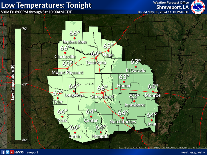
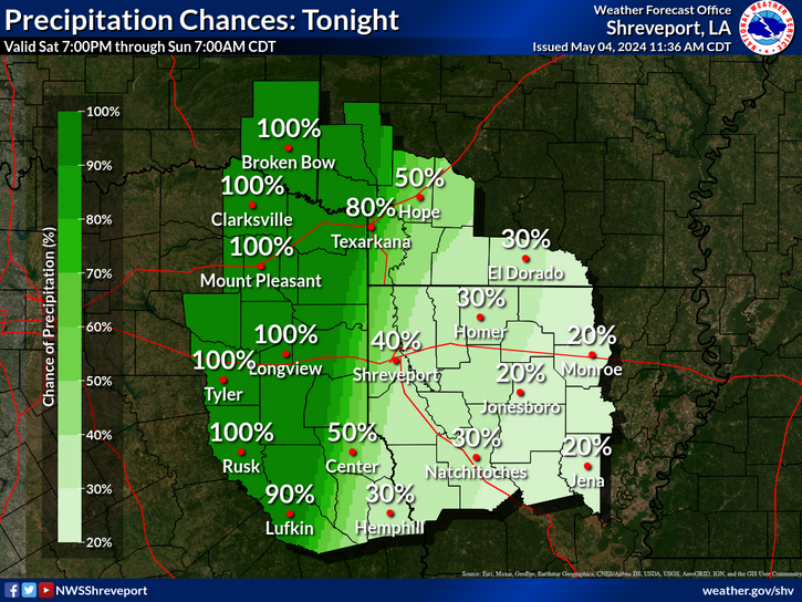
Isolated strong to severe thunderstorms capable of producing large hail and damaging wind gusts will be possible this evening across west-central Texas. Elevated to Critical fire weather conditions will persist across the southern Rockies and portions of the southern Plains through this weekend. Read More >

Click a location below for detailed forecast.

Last Map Update: Wed, Apr. 24, 2024 at 11:10:16 pm CDT

National Weather Service Tulsa, OKNational Weather Service Little Rock, ARNational Weather Service Memphis, TN
National Weather Service Fort Worth/Dallas, TXZoom
Out

National Weather Service Jackson, Mississippi
National Weather Service Houston/Galveston, TXNational Weather Service Lake Charles, LANational Weather Service New Orleans/Baton Rouge


There is a risk for severe thunderstorms beginning Friday and continuing through the weekend. The severe risk expands to include nearly all of the region on Sunday. Stay tuned to the latest forecast, and review your severe weather safety plan as this potential comes into better focus over the next few days.
Can't rule out an isolated shower or thunderstorm near a stalled boundary overnight.
Expect overnight low temperatures to range from the lower to mid 60s with partly to mostly cloudy skies and light winds.
Here are the daily climate data for selected cities in our Four-State area.

Latest Text Product Selector (Selected product opens in a new window)


 Current Weather Observations...
Location Time
(CDT)
Weather Vsby.
(SM)
Temp.
(ºF)
Dewpt.
(ºF)
Hum.
(%)
Wind
(mph)
Wind Chill / Heat Index
(ºF)
Pres.
(in)
De Queen AR21:53Clear10676490E 3-30.06
El Dorado AR21:53Clear10666493CALM-30.11
Henderson TX22:35Clear10726683CALM-30.08
Idabel OK22:35Mostly Cloudy106868100E 8-30.08
Longview TX21:53Clear10706790SE 3-30.07
Lufkin TX21:53Clear10726681SSE 6-30.07
Monroe LA21:53Clear10726681SE 3-30.10
Mount Pleasant TX22:35Clear1068CALM-30.07
Nacogdoches TX22:53Mist1 1/466CALM-30.09
Natchitoches LA22:35Clear106767100CALM-30.09
Shreveport LA (Regional Airport)21:56Mostly Clear10736678CALM-30.07
Shreveport LA (Downtown Airport)21:53Clear10726578E 3-30.08
Texarkana AR21:53Clear10706584ENE 6-30.09
Tyler TX21:53Clear10736678E 5-30.06


Submit Storm Report Local Shreveport Radar Local Hazards Forecast Maps Graphical Forecasts Rivers and Lakes
Submit Storm Report Local Shreveport Radar Local Hazards Local Forecast Page Graphical Forecasts Rivers and Lakes
           
Current Observations Aviation Weather Fire Weather CoCoRAHS Information Hourly Forecasts Tropical Weather
           
Drought Information COOP Program Latest Public Information Statement Weather Radio Past Events Storm Spotter Training
Drought Information Cooperative Observer Program Public Information Statement Weather Radio Past Events Spotter Training