
Severe thunderstorms capable of producing damaging wind gusts, large hail, and a few tornadoes, are likely to develop this afternoon from parts of the lower Ohio Valley into the southern Plains. An Enhanced Risk (Level 3 of 5) outlook has been issued. Further north, widespread rain showers are expected across portions of the Great Lakes and Northeast U.S. Read More >
| Overview | |||||||||||||||||||||||
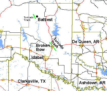
| Severe thunderstorms brought tornadoes to McCurtain County in Southeast Oklahoma on May 1st, 2003. One tornado, rated F0, affected areas near Battiest. Another tornado, rated F2, impacted Broken Bow. Below is a summary of the tornadoes that were confirmed by National Weather Service officials. | |||||||||||||||||||||||
|
TOTAL TORNADO COUNT = 2
|
|||||||||||||||||||||||
|
Tornado Table
Graphics
|
|||||||||||||||||||||||
| Back to Top | |||||||||||||||||||||||


 Follow us on YouTube