
Isolated strong to severe thunderstorms capable of producing large hail and damaging wind gusts will be possible this evening across west-central Texas. Elevated to Critical fire weather conditions will persist across the southern Rockies and portions of the southern Plains through this weekend. Read More >
| Overview | ||||||||||||||||||||||||||||||||||||||||||||||||||||
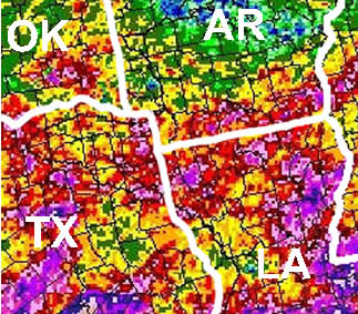
| The month of June was quite soggy across the Four State Region. Rainfall generally ranged between 8 and 12 inches. A dry day across the area was hard to come by as the weather pattern was quite persistent. An unusually strong and almost stationary upper low across Southeast Canada pushed cold fronts unusually far to the south. These fronts would move in the Lower Mississippi Valley and stall out before reaching the coast. In addition, a persistent weak trough was located across Texas for most of June cut off from the main flow. These features combined with a very moist and unstable atmosphere to make for one of the wettest Junes on record. A few daily rainfall and coolest high temperature records were set during the month. The first couple of days of June saw widespread damage from winds and some hail by a few complexes of storms that moved through the area. These thunderstorms also produced some heavy rainfall. Almost daily rainfall from late May through early June saturated the ground setting up the possibility of flash flooding. Some flooding was observed, mainly in urban, low-lying or poor drainage areas when thunderstorms moved very little or moved over the same area for hours at a time. River flooding was kept to a minimum. However, rivers such as the Glover River in Southeast Oklahoma, would rise 6 to 8 feet over a few hours due to the excessive rainfall. |
|
|||||||||||||||||||||||||||||||||||||||||||||||||||
| Rainfall Totals | ||||||||||||||||||||||||||||||||||||||||||||||||||||
|
||||||||||||||||||||||||||||||||||||||||||||||||||||
| Back to top | ||||||||||||||||||||||||||||||||||||||||||||||||||||


 Follow us on YouTube