Severe Thunderstorms Likely Across the Ozarks and Lower Ohio Valley
Severe thunderstorms capable of producing damaging wind gusts, large hail, and a few tornadoes, are likely to develop this afternoon from parts of the lower Ohio Valley into the southern Plains. An Enhanced Risk (Level 3 of 5) outlook has been issued. Further north, widespread rain showers are expected across portions of the Great Lakes and Northeast U.S.
Read More >
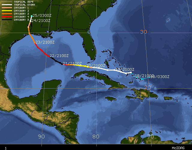
Tropical Depression Eighteen formed just east of the Turks late on September 17th, 2005. This depression became the 17th named storm of the 2005 Atlantic Hurricane Season on Sunday, September 18th, in the Bahamas. Tropical Storm Rita became the ninth hurricane in the Atlantic Basin during the morning of September 20th. She intensified to a Category 5 hurricane on Wednesday, September 21st. Her lowest pressure measured by Hurricane Hunters was 897 mb, or 26.49 inches. This made her the third most intense hurricane in terms of pressure in the Atlantic Basin behind Hurricane Gilbert in 1988 and the Labor Day Hurricane in 1935. Hurricane Katrina, only a month earlier, had the distinction of being of being the third most intense hurricane in terms of pressure prior to Rita. Hurricane Rita's top sustained winds were 175 mph. Thankfully, she did weaken somewhat before making landfall early on Saturday, September 24th, near the Texas and Louisiana border near Sabine Pass, with sustained winds of 120 mph (Category 3). Due to the strength and speed of Rita, Inland Hurricane Warnings had to be issued as far north as the East Texas Lakes Region as well as Inland Tropical Storm Warnings for portions of East Texas and West Central Louisiana.
Shreveport recorded its second lowest pressure ever recorded as the center of Rita moved through Shreveport around 6pm on Saturday, September 24th, 2005. The pressure recorded was 29.05 inches (983.7 mb), which was only 0.01 inch higher than the lowest pressure on record of 29.04 inches on February 27th, 1902.
Track of Hurricane Rita. This track map is courtesy of the University of Wisconsin-Madison, Cooperative Institute for Meteorological Satellite Studies. Click here for an interactive map.
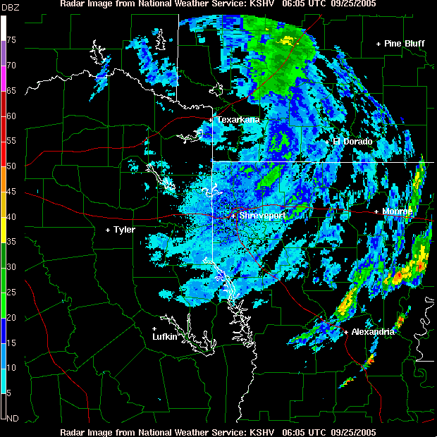
Radar loop from Shreveport, LA, of Hurricane Rita moving northward through the Four State Region.
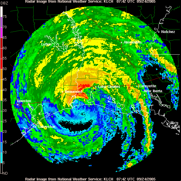
Radar loop from Lake Charles, LA, of Hurricane Rita making landfall near Sabine Pass and the Texas/Louisiana border.
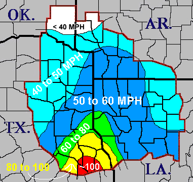
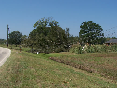
Peak wind gusts of 40 to 60 mph occurred Saturday, September 24th, across extreme Southeast Oklahoma, Southwest Arkansas, and the western sections of Northeast Texas and also across all of Northwest Louisiana and North Central Louisiana as Rita pushed northward. Peak wind gusts were much greater closer to the remnant eyewall over Deep East Texas with estimated gusts near 85 mph in Center, TX, and also an unofficial wind gusts of around 100 mph near Sam Rayburn Reservoir in Lower East Texas. The most widespread structural damage occurred in Angelina and San Augustine Counties, but widespread tree and power line damage was also reported in Angelina, Nacogdoches, Sabine, San Augustine, and Shelby Counties in Deep East Texas and in Sabine Parish in West Central Louisiana. In Angelina County, approximately 50 to 75 homes and businesses suffered mostly minor structural damage from either high winds or fallen trees. The damage from Rita was not as extensive across the rest of Northeast Texas and Northern Louisiana, but still many trees and power lines were down due to the strong winds. At the height of the storm over 175,000 people had lost power in the NWS Shreveport forecast area, mainly across Deep East Texas into Northwest Louisiana. Two fatalities occurred in Angelina county. A tree fell on a person, and the other fatality occurred when a teenager was electrocuted when picking up a "hot" power line.
Map of peak winds from Hurricane Rita
These photos were taken in Angelina County, but these scense could be
repeated across much of East and Southeast Texas and Western Louisiana.
Selected Peak Wind Gusts
LOCATION
PEAK WIND GUSTS
Sam Reyburn Reservoir, TX
~100 mph
Center, TX
~85 mph
Shreveport, LA
53 mph
Texarkana, AR
52 mph
Longivew, TX
51 mph
Downtown Shreveport, LA
49 mph
Tyler, TX
49 mph
Idabel, OK
49 mph
El Dorado, AR
49 mph
Monroe, LA
43 mph
Broken Bow, OK
36 mph
De Queen, AR
33 mph
Mount Herman, OK
27 mph
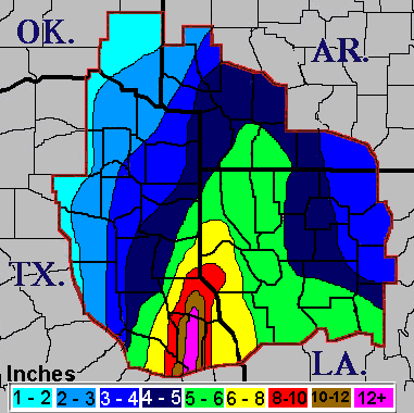
Although Hurricane Rita did not stall across East Texas, the storm still dropped copious amounts of rainfall. Two to five inches of rain were common across the area, with 10.48 inches recorded at Center, TX.


 Follow us on YouTube