
Severe thunderstorms, excessive rainfall, critical fire weather are all in the outlook today and into this last weekend of April. Very large hail, severe wind gusts, and a couple strong tornadoes will all be possible across the central and southern Plains today. Flash flooding also possible for portions of the Plains and Mississippi Valley. Critical fire weather conditions for Southern High Plains Read More >
| Overview | |||||||||||||||||||||||||||
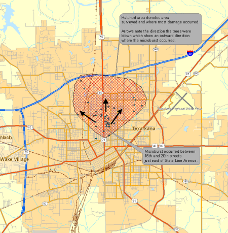
| The National Weather Service in Shreveport conducted a survey of damage that occurred in the city of Texarkana on both the Arkansas side and Texas side and found that a microburst producing winds up to 100 mph occurred. An analysis of radar data leading up to the damage shows two severe thunderstorms coming together on the south side of the city. One severe storm was moving northeastward from Southern Bowie County while the other was moving northwestward through Miller County. Both storms collided in an area just south of Downtown Texarkana. As a result of the collision, the storm cores collapsed in an area just east of State Line Avenue over a several block area between 16th and 20th Streets. Numerous large trees were snapped or uprooted onto homes and cars in the Glendale subdivision. As the survey expanded outward to the north near 24th Street and Woodlawn Cemetery, trees were noted to have fallen in a north or northeastward direction typical of a microburst. Damage was found as far northeast as the Calvary Cemetery area with trees downed in a north to northeast direction. Trees were also uprooted and snapped on the Texas side of State Line Ave., with a heavier concentration along Magnolia Street between 24th and 30th Streets. It was noted that the trees fell in a northwesterly direction, which would be expected if a microburst had occurred to the south and east of those locations. Numerous homes were damaged on the Texas side of State Line Avenue as a result. Power lines were also downed throughout the area as a result of either poles snapping or trees falling on the lines. The area impacted by the microburst is approximately 3.5 miles long to the northeast of the origin and 4 miles in width from one end of the damage swath to the other. City and county officials estimate at least 44 homes sustained major damage with an unknown number of cars damaged. At least 100 damage reports have been collected. Officials also reported that over 900 911 calls were made during the first hour following the storm. Only one minor injury occurred when a tree fell on a house injuring the elderly woman inside. |
|||||||||||||||||||||||||||
|
Graphics
Photos
|
|||||||||||||||||||||||||||
| Back to Top | |||||||||||||||||||||||||||


 Follow us on YouTube