
A few strong to marginally severe thunderstorms are possible across the Southeast U.S. Friday. A Marginal Risk (Level 1 of 5) outlook has been issued. Strong winds and hail will be the main threats. Elevated to locally critical fire weather conditions will persist across south-central Colorado today due to dry conditions and gusty winds. Read More >
| Overview | ||||||||||||||||||||||||||||||||||||||||||||||||||||||||||||||||||
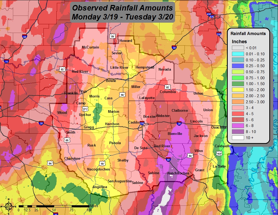
| A large, and slow-moving upper level storm system brought heavy rain and tornadoes to the Four State Region during the night of March 19, 2012, before exiting the area during the evening hours of March 21, 2012. The upper level trough dove south across the Pacific Coast and moved east across the Desert Southwest. By Monday, this large upper trough became "cut off" from the main upper level jet stream. With no main flow steering the trough, it moved very slowly eastward into West Texas and near the Red River between Texas and Oklahoma. Southerly flow aloft and at the surface ahead of the low provided a rich stream of moisture from the Pacific Ocean and the Gulf of Mexico. The abundant moisture, combined with the slow moving storm system set the stage for a long-duration heavy rain event over much of the Four State Region beginning late Monday, March 19. | ||||||||||||||||||||||||||||||||||||||||||||||||||||||||||||||||||
|
Rainfall began first across portions of Northeast Texas where several inches fell during the late night of Monday, March 19. By mid morning on Tuesday, March 20, heavy rain had spread into adjacent portions of Northwest Louisiana and Southwest Arkansas. The strongest thunderstorms within the main convective band continually occurred south of Interstate 20 and along and just east of Interstate 49, particularly in Natchitoches Parish. Flash flooding occurred through Northwest Louisiana with several roads being closed. There were also a few swift water rescues. Flooding was very severe around Natchitoches and Nachez. Some schools were closed due to the flooding in Natchitoches Parish. Rainfall amounts in excess of 8" were common in Central and Southern Natchitoches Parish. An automated RAWS observation site at Natchitoches recorded over 10" of rain!
|
|
|||||||||||||||||||||||||||||||||||||||||||||||||||||||||||||||||
| In addition to the flooding threat, a high amount of low-level wind shear contributed to produce a few tornadoes with the strongest storms on Tuesday and Wednesday, March 21. Several reports of suspected tornado damage were received from various locations in Northwest and North Central Louisiana Tuesday and early Wednesday. Meteorologists from the National Weather Service in Shreveport conducted surveyed the damage on March 21, 2012. The report is presented in chronological order of when the tornadoes occurred. | ||||||||||||||||||||||||||||||||||||||||||||||||||||||||||||||||||
|
TOTAL TORNADO COUNT = 5
|
||||||||||||||||||||||||||||||||||||||||||||||||||||||||||||||||||
|
Tornado Table
Damage Map
Coming Soon |
||||||||||||||||||||||||||||||||||||||||||||||||||||||||||||||||||
| Back to Top | ||||||||||||||||||||||||||||||||||||||||||||||||||||||||||||||||||


 Follow us on YouTube