| TOR. # |
START POINT |
END
POINT |
RATING |
PEAK WIND |
START TIME |
END TIME |
LENGTH/
WIDTH |
FATALITIES/
INJURIES |
REMARKS |
| APRIL 29, 2016 |
| #1 |
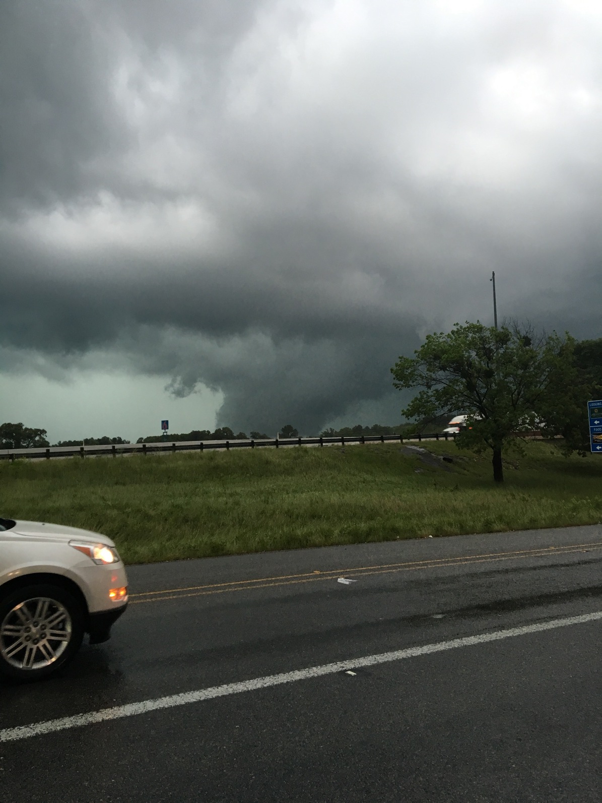
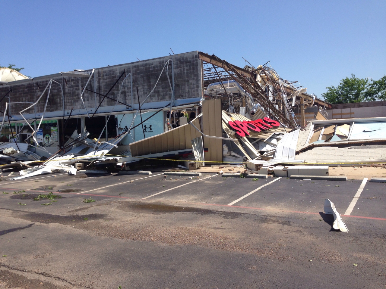
1 mile S of Lindale, Smith County, TX |
0.5 mile SE of Lindale, Smith County, TX |
EF2 |
110-115 mph |
5:50pm CDT |
5:54pm CDT |
5 miles/
550 yards |
None |
This tornado began just west of US-69 near the intersection of US-69 and Mayor Street. Initial damage was to trees and minor roof damage to homes. As the tornado crossed US-69, it caused major damage to the Hibbett Sports and Dollar Tree stores on the east side of US-69. Roof damage occurred in subdivisions between US-69 and County Road 431. The tornado lifted near the intersection of County Road 431 and Pierce Street. |
| #2 |
2.5 miles SE of Lindale, Smith County, TX |
9 miles WSW of Bettie, Upshur County, TX |
EF2 |
120-125 mph |
5:55pm CDT |
6:32pm CDT |
27.36 miles/
1.83 miles |
2 injuries |
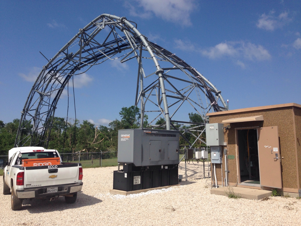
This long-track, multi-vortex tornado began near the intersection of CR 499 and CR 4100 near Lindale, TX. The tornado traveled northeast through Smith, Wood, and Upshur Counties. Most of the damage consisted of numerous trees being snapped and uprooted. The Ozarka Water bottling plant north of Hawkins, TX, sustained major roof damage. Damage consistent with EF-2 wind speeds was found in Smith County between Farm-to-Market Roads 16 and 2710 where a cell phone tower, a house, and two mobile homes sustained major damage. This tornado eventually lifted in Upshur County near Farm-to-Market Road 852 between Horse Road and Greyhound Road. |
| #3 |
4.32 miles SW of Alto, Cherokee County, TX |
3.09 miles N of Alto, Cherokee County, TX |
EF2 |
105-115 mph |
7:33pm CDT |
7:45pm CDT |
7.3 miles/
820 yards |
None |
This tornado began along County Road 2807 just east of Farm-to-Market Road 220. Over 27 homes sustained damage, including two homes that completely lost their roofs. Several outbuildings were damaged or destroyed, and at least two travel trailers were destroyed. The tornado lifted north of County Road 2438. |
| #4 |
5.71 miles SW of Reklaw, Cherokee County, TX |
4.66 miles SW of Reklaw, Cherokee County, TX |
EF1 |
95-105 mph |
7:54pm CDT |
7:56pm CDT |
0.75 miles/ 150 yards |
None |
This tornado touched down in a wooded area southwest of Reklaw and moved through a cluster of new chicken coops before lifting. |
| |
10 miles S of Longview, Rusk County, TX |
--- |
Straight-line
winds |
85-95 mph |
8:48pm CDT |
--- |
--- |
None |
Several trees were uprooted or snapped along County Road 240 and County Road 246. |
| #5 |
13.5 miles SSE of Marshall, Harrison County, TX |
12.0 miles SE of Marshall, Harrison County, TX |
EF1 |
95 mph |
10:21pm CDT |
10:33pm CDT |
5.65 miles/
820 yards |
None |
This tornado began in extreme southern Harrison County just south of County Road 1311. It traveled northeast and parallel with Caney Creek before lifting just west of County Road 1207. Most of the damage consisted of uprooted, broken, and twisted trees. |
| #6 |
4.0 miles NW of Waskom, Harrison County, TX |
8.4 miles N of Waskom, Harrison County, TX |
EF1 |
105 mph |
10:46pm CDT |
10:59pm CDT |
5.75 miles/ 200 yards |
None |
This tornado began east of County Road 2705 and just north of Farm-to-Market Road 134. It uprooted several trees and traveled north-northeast severely damaging two mobile homes along Bennett Road off of County Road 2705. Scattered tree and power line damage occurred along FM 9 and several trees were uprooted and snapped along FM 1999. |
| APRIL 30, 2016 |
| #7 |
4.9 miles NNW of Marshall, Harrison County, TX |
7.8 miles NE of Marshall, Harrison County, TX |
EF1 |
110 mph |
12:34am CDT |
12:46am CDT |
6.63 miles/
350 yards |
None |
This tornado began just west of County Road 4000 twisting and knocking down numerous trees. It traveled east-northeast crossing US Hwy 59 near the Karma Farm. Two homes were damaged in this area. The tornado continued east-northeast clearing huge swaths of trees and eventually lifted near the intersection of County Road 2107 and Buckhorn Road. |
| #8 |
8.0 miles S of Stamps, Columbia County, AR |
6.5 miles SSW of Buckner, Lafayette County, AR |
EF1 |
90-100 mph |
12:41am CDT |
12:44am CDT |
1.5 miles/
900 yards |
None |
The tornado began just south of Columbia County Road 1 and traveled north-northeast crossing into Lafayette County and lifted along County Road 21 just south of the intersection with County Road 81. Damage consisted of snapped and uprooted trees. |
| #9 |
3.0 miles N of Waldo, Columbia County, AR |
3.0 miles N of Waldo, Columbia County, AR |
EF1 |
95 mph |
1:09am CDT |
1:09am CDT |
0.25 miles/
130 yards |
None |
This brief tornado touched down just southwest of US Highway 371 south of the intersection with Columbia County Road 60. The tornado cross Highway 371, snapped several trees, and quickly dissipated. |
| #10 |
9.0 miles SE of Broaddus, San Augustine County, TX |
11.6 miles SE of Broaddus, San Augstuine County, TX |
EF1 |
95-105 mph |
4:44am CDT |
4:51am CDT |
3.3 miles/
380 yards |
None |
The tornado began along the northern shore of Sam Reyburn Lake in the Anthony Harbor subdivision. Numerous trees were snapped as it moved northeast to Highway 83. The tornado crossed the lake north of the Ayish Bayou Bridge damaging two electrical transmission line towers. The tornado snapped and uprooted more trees before finally lifting as it cross Farm-to-Market Road 1751. |


 Follow us on YouTube