
Isolated strong to severe thunderstorms capable of producing large hail and damaging wind gusts will be possible this evening across west-central Texas. Elevated to Critical fire weather conditions will persist across the southern Rockies and portions of the southern Plains through this weekend. Read More >
Overview
The NWS Spot Forecast Request and Dissemination System provides users a way to request fire weather spot forecasts and National Weather Service (NWS) forecasters a way to post those forecasts to a national web server. It was developed with three main design principles:
- ease of use for the spot forecast requestor,
- quicker production of spot forecasts at the NWS office,
- provision of a "one-stop-shopping" location on the web for weather information pertaining to a particular burn or wildfire.
Features
NWS Spot centers around a daily spot forecast "monitor" page that shows all the spot forecast requests for a particular office on a particular day. Links are provided on this page to
- request a spot forecast,
- view detailed information about each spot forecast, and (
- view information for other days.
The ‘detailed' web page for each spot forecast contains information about the request, maps of the area, and the completed forecast, and is set to automatically update on most browsers as information is released.
Spot Forecast Monitor Page
The main spot forecast monitoring page shows you all of today's spot forecasts on the map and also in the list at the bottom of the page.
This page auto-updates every minute, so as new spot forecasts are requested or their status changes, you immediately see the changes on the page.
The dots on the map show the locations of the burns, and the status of the spot forecast requests. Green squares indicate requests that are still pending. Purple squares indicate burns where questions have been asked. Red squares indicate burns where the forecast has been completed. You can either click on the dots on the map, or the list of spot names at the bottom of the page to view the individual webpage for each request.
You can use the arrow buttons next to the date to view spot requests from other days, or you can use the "CALENDAR" link to move to other days more quickly.
Each request has its own webpage where all the information about that request is displayed, including maps, information about the request and, eventually, the forecast. Sensitive information about the request (such as phone numbers, names of contact persons, and the exact location of the burn) are NOT visible by everyone, but only on the computer that made the original request and NWS computers.
When you request a new spot forecast, you provide information in a web-based form. The information you provide on the form is checked for consistency, and after you complete the form, the NWS is notified of a new request and a new webpage is created for this burn.
Once you have submitted a request, you will probably want to view the webpage for your burn, or check back frequently to view it's status. To view the webpage for any burn or wildfire, go to the main spot forecast webpage, click either on the name of the burn in the listing, or on the dot on the map for the burn. This page will also automatically update every minute so that when new information becomes available, you will see it right away. If we find any errors in your request, we might even send you a question that will show up on this page. You can answer the question, or make other changes to your request from this webpage, but ONLY from the computer that made the original request. Since the forecast screen is automatically updated very minute, you will see the forecast within a minute of it being issued.
When the forecast is complete, you can print the webpage, or do whatever you want with the information. From the main spot forecast page, you have the ability to switch to a similar screen for days other than today. You can use this to send us feedback on earlier forecasts, or to copy the information from one request to a new request for today.
To request a spot forecast, click on the link labeled "Submit a new Spot Request", and you will be taken to the Spot Request Form.
Spot Requestor Form and instructions
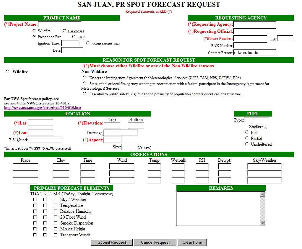
Required Fields ( are in red on the request page)
Project Name - If your incident has a name, go ahead and put it in. Otherwise, use a combination of the nearest city or town and the distance from that location. For example, if the incident site is approximately 5 miles west of Guanica. Then the fire name would be 5W Guanica.
Select whether the type of incident is a wildfire, prescribed burn or HAZMAT. If it is a prescribed burn, please enter the Ignition Time (using a 24 hour clock) and Date.
Requesting Agency - The requesting agency name and telephone number. Fax number and contact person are optional, but we consider those important if we have any questions or a breakdown in dissemination capabilities.
Reason for Spot Forecast - The requester of a spot forecast must provide the "REASON FOR THE SPOT FORECAST". The NWS cannot provide spot forecasts to private citizens or commercial entities not acting in a capacity as agent to a government agency.
Spot forecasts for WILDFIRES or HAZMAT will be provided to any federal, state, or local official who represents that the spot forecast is required to support an incident for protection of life or property.
Spot forecasts for NON-WILDFIRE purposes will be provided for any of the following criteria:
Under the Interagency Agreement for Meteorological Services (USFS, NPS, USFWS, DOD).
State, or local fire agency working in coordination with a federal participant in the Interagency Agreement for Meteorological Services.
Essential to public safety, e.g. due to the proximity of population centers or critical infrastructure.
...IMPORTANT...
Location - Enter the Latitude and Longitude of the fire location. You can either specify:
Degrees in hundredths, in the following format example: latitude 18.20 longitude -66.25
or
Degrees/minutes/seconds as in this format example: latitude 27 48 34 longitude 80 34 05 (note the space between numbers.)
The NWS prefers to receive location information in latitude and longitude coordinates because it is easier to locate the incident location more precisely on our computer equipment. However, you may also use a legal description of Township, Range and Section (TRS) format.
If you enter the location in TRS format, follow this example: T39N R7E SEC8. The NWS Spot program will convert the TRS description to latitude/longitude when it is processing the request.
Proper location data will give us detailed information on the location of the fire and relation to bodies of water or population centers..etc..
Elevation - If the burn or fire is on flat ground, you can enter a value in only one of the boxes, preferably the one labeled Top.
Drainage references the river drainage basin the fire is in. This field is optional, but the information would be helpful if known.
Aspect - The direction the slope (if any) faces. Use direction references such as N, NE, E, SE, S, SW, W, NW. If the fire or burn is in flat terrain, you can type in "FLAT".
Enter the size or acreage of the spot burn if known, however it is not a required field.
Observation - Although not shown in red, a recent observation should be provided. For each observation, we need to know its relation to the site of the prescribed burn or wildfire, the elevation in feet, and the time. The wind information can be specified as N12 gust 25 mph or West at 10 mph. Please specify the height off the ground at which your wind measurement was taken, i.e. eye level or 20 foot winds. The forecast will be for 20 foot winds.
The temperature and wet bulb values in degrees F should be entered, and the RH (in percent) and the Dew point (F) if known. Finally, any remarks about clouds, weather or other important information would be helpful.
Primary Forecast Elements - You may request data for Today, Tonight and Tomorrow by checking the boxes under "Primary Forecast Elements" in the lower left corner of the Spot Forecast Request page illustrated in figure 2 above. The NWS asks that you request no more than you actually need at the time to perform your work that day.
Remarks - If a meteorological parameter is not listed and you would like a forecast of that information, enter the request in the Remarks section. You can also ask questions or state any concerns or problems.
Action - You have three options. When your request for a forecast is complete, click on the "Submit Request" button at the bottom of the page. Various checks are performed on the data you have entered. If an error is found, you will be taken to a page that describes the error. You would then click on "Go Back and Fix" which would take you back to the Spot Request Forecast page. Correct any errors, and then click on the Submit Request button once again.
The "Cancel Request" will end your request. The "Clear Form" button will erase all your entries, enabling you to start over.
The spot request will alarm at the NWS - San Juan fire weather forecaster's work station, but to ensure we received the request, please call us to ensure that the request was received.
Once your request is submitted, the NWS Spot program will respond with a forecast page.


 Graphical Hazardous Weather Outlook
 Tropical Analysis
 Tropical Weather
 Regional Satellite
  Puerto Rico and U.S. Virgin Islands
 Local Radar