Deadly Tornado Outbreak
January 22, 2017
An Analysis of the Synoptic and Mesoscale Environments (PDF)
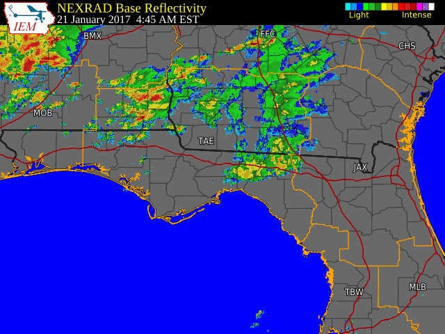
A multi-day severe weather event struck the southeast January 21-22, 2017 with three rounds of severe weather moving through the area. The first round of severe weather started during the mid-morning hours on Saturday, January 21, 2017 as a squall line pushed into southeast Alabama and the Florida panhandle. As it pushed eastward nine warnings were issued with a total of 18 damaging wind reports (trees and power lines downed) related to these storms.
After a brief lull during Saturday evening as the aforementioned squall line washed out near the Gulf Coast, strong southerly flow returned late Saturday night as a warm front pushed northward across the Florida Big Bend and southern Georgia. Initially with this late Saturday night to early Sunday morning event, a strong supercell moved across southern Georgia producing a tornado that moved across Thomas and northern Brooks Counties. This was the first tornado across the area with this multi-day event. From the same supercell that produced the tornado in Thomas and northern Brooks Counties, another tornado developed that tracked across Brooks, Berrien and Cook Counties and this tornado resulted in 11 fatalities. This overnight into early Sunday morning event produced one more tornado, an EF-1 that struck Lowndes County.
A final round of severe weather moved through Sunday afternoon as a warm front continued to push northward into southeast Alabama and southern Georgia while the main low and trailing cold front pushed eastward across the Florida panhandle and offshore regions. This afternoon round of supercells first produced a tornado in Henry County, AL. An hour and a half after the Henry County tornado, two more tornadoes developed, an EF-2 that struck Clay, Randolph and Calhoun Counties (Georgia) and an EF-1 tornado that hit Franklin County, FL. After this, a long tracked tornado (track length of more than 70 miles) moved across Albany (Dougherty County) and into Worth and Turner Counties, causing extensive damage and five fatalities.
Overall this multi-day event resulted in seven tornadoes, 16 deaths and numerous injuries. Three days of damage surveys were conducted to rate the tornadoes on the Enhanced Fujita scale and the results for each tornado are presented below. Thank you to our emergency management and media partners for their help in disseminating the weather warnings and gathering damage information.

| Click on tornado tracks for details Full Size Image |
| Figure Courtesy of Iowa Environmental Mesonet Copyright Iowa State University |
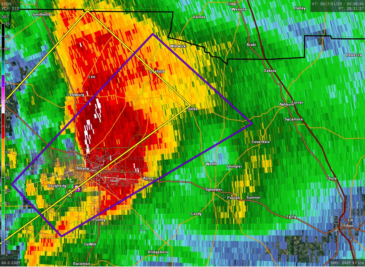
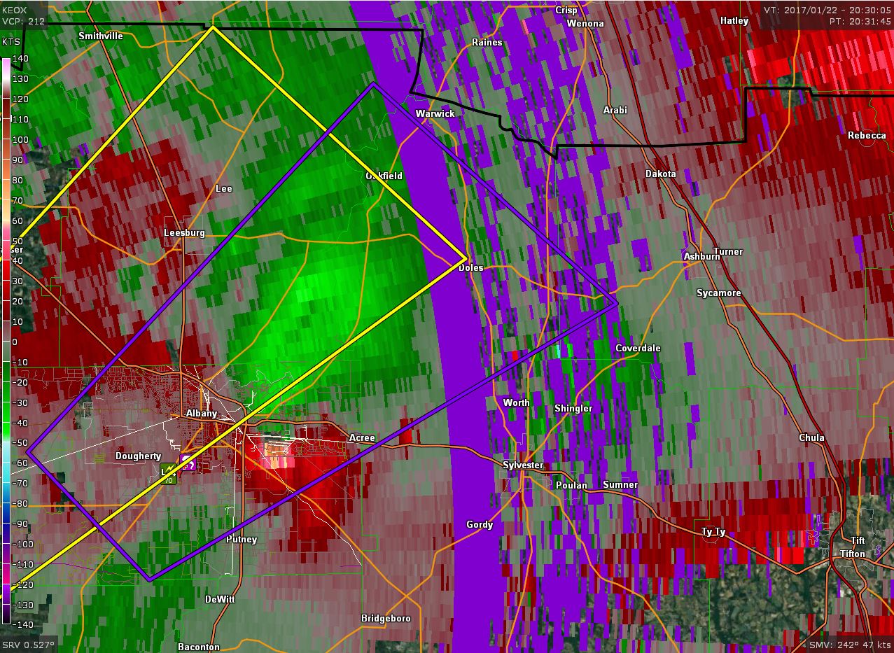
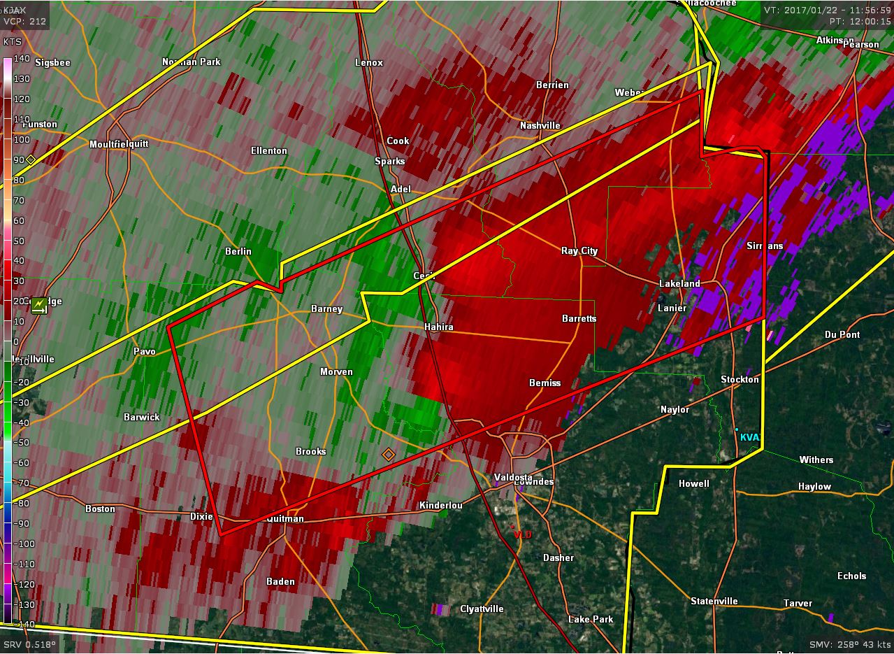
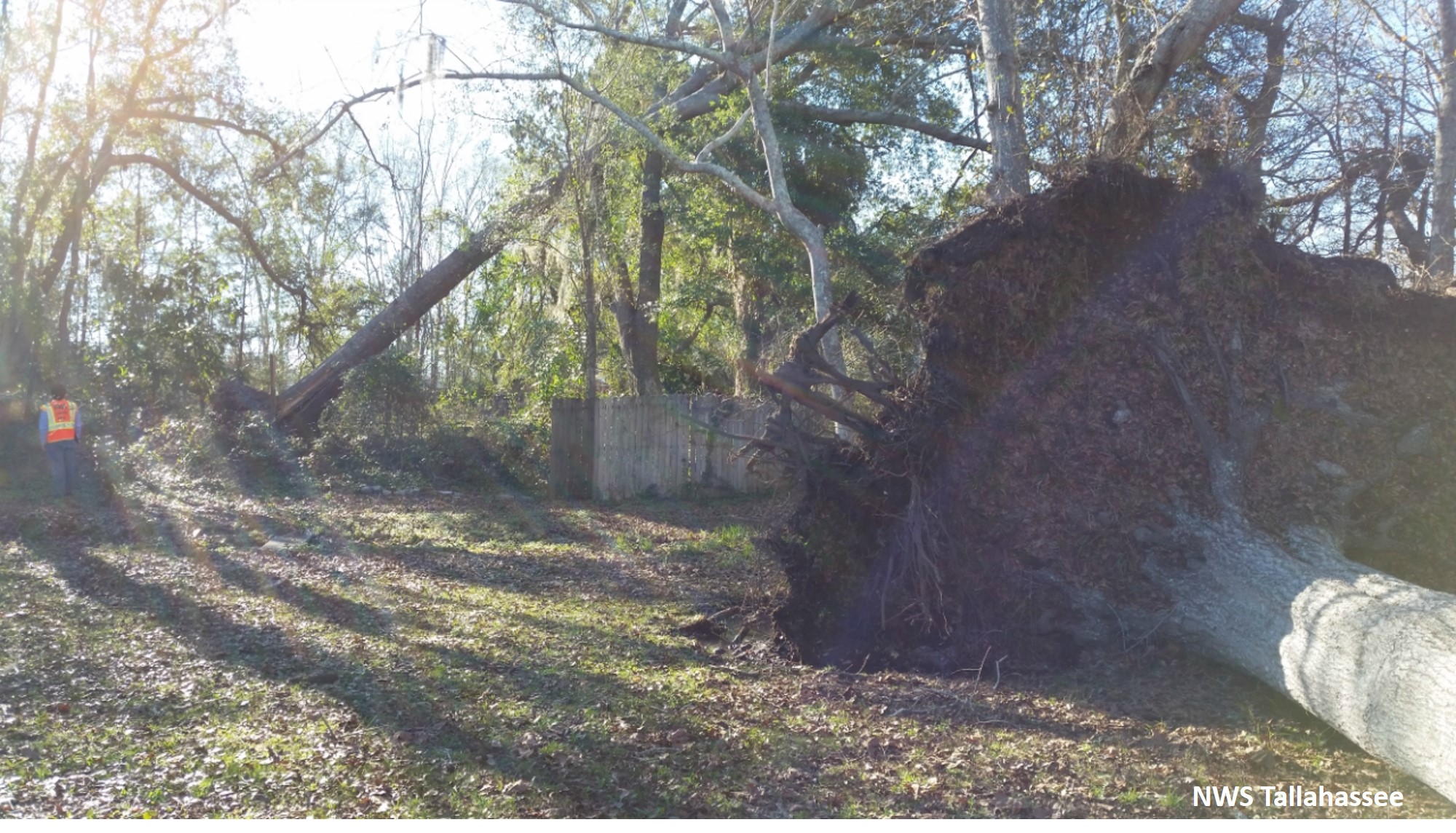
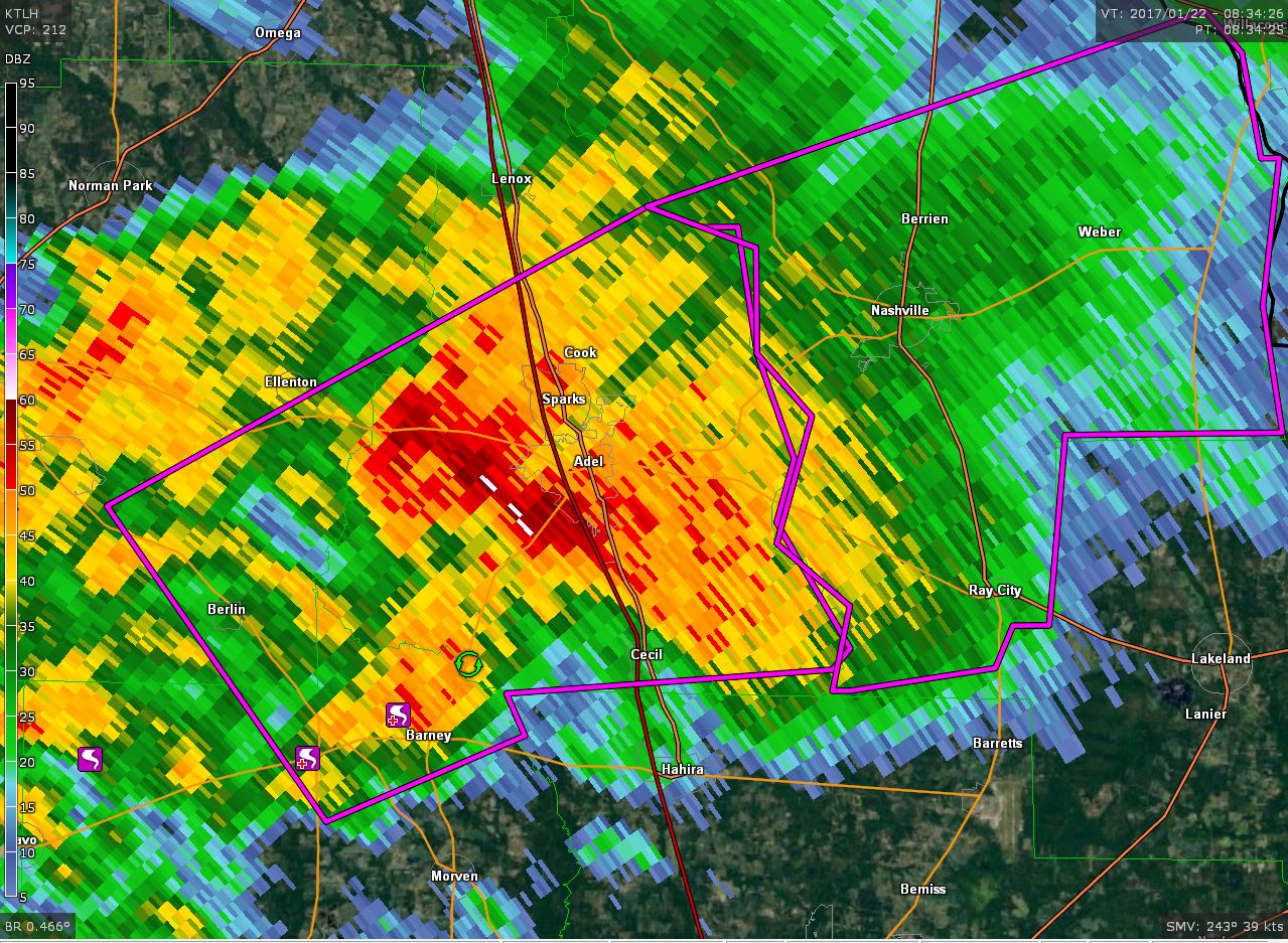
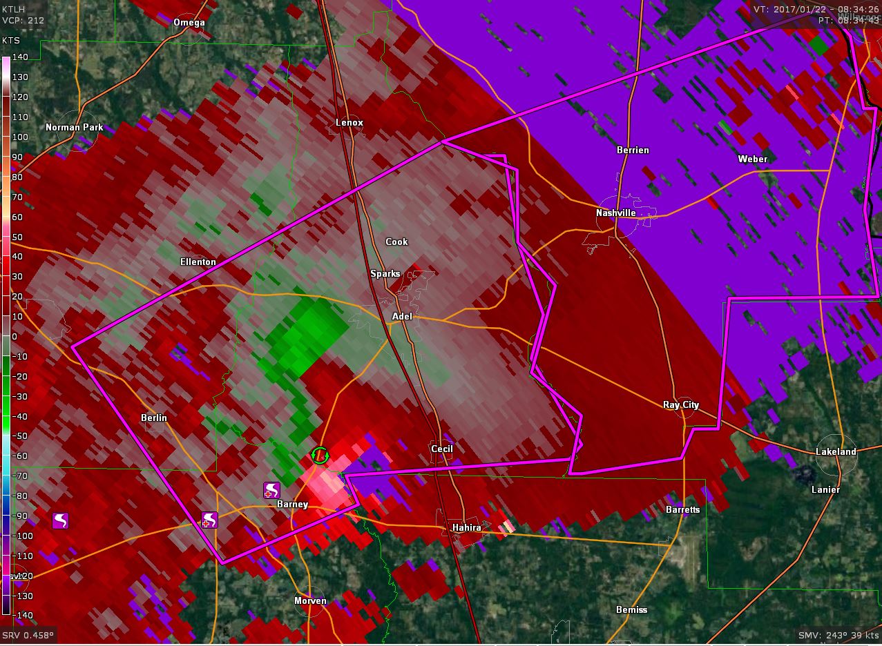
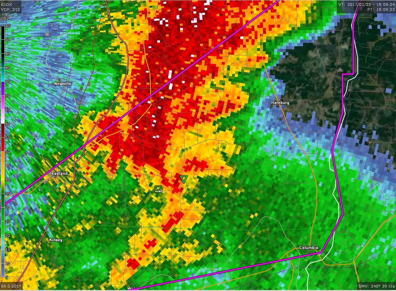
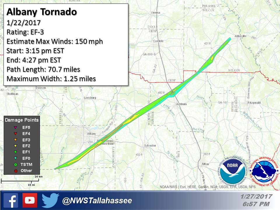
Rating:                 EF3
Estimated Peak Wind:    150 mph
Path Length /statute/:  70.73 miles
Path Width /maximum/:   1.25 miles
Fatalities:             5
Injuries:               At least 40
Start Date:             01/22/2017
Start Time:             03:15 PM EST
Start Location:         4 WNW Red Store Crossroads/Dougherty Co/GA
Start Lat/Lon:          31.4373 / -84.3447

End Date:               01/22/2017
End Time:               04:27 PM EST
End Location:           2 W Abbeville / Wilcox Co / GA
End Lat/Lon:            31.9924 / -83.3474
|
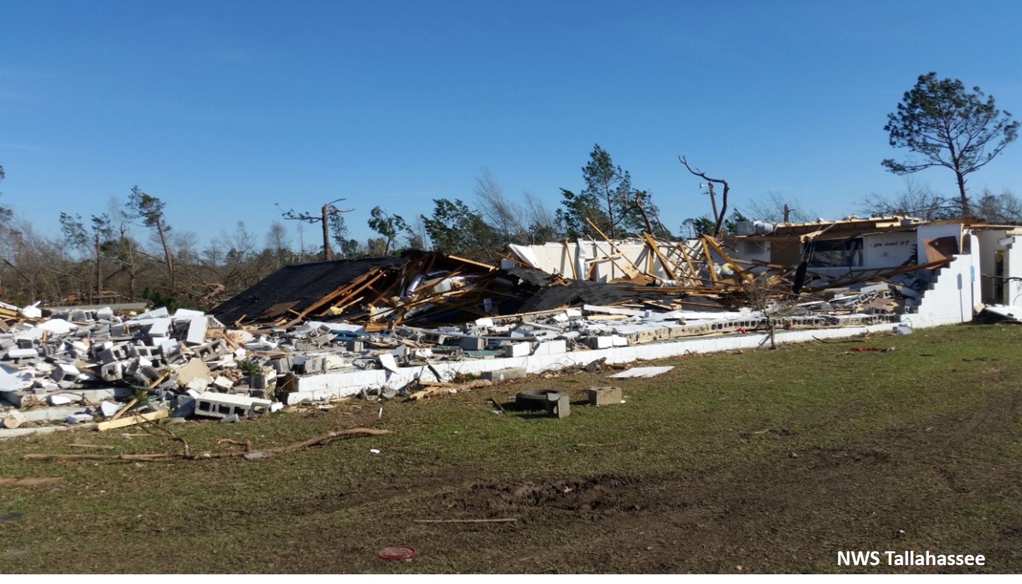
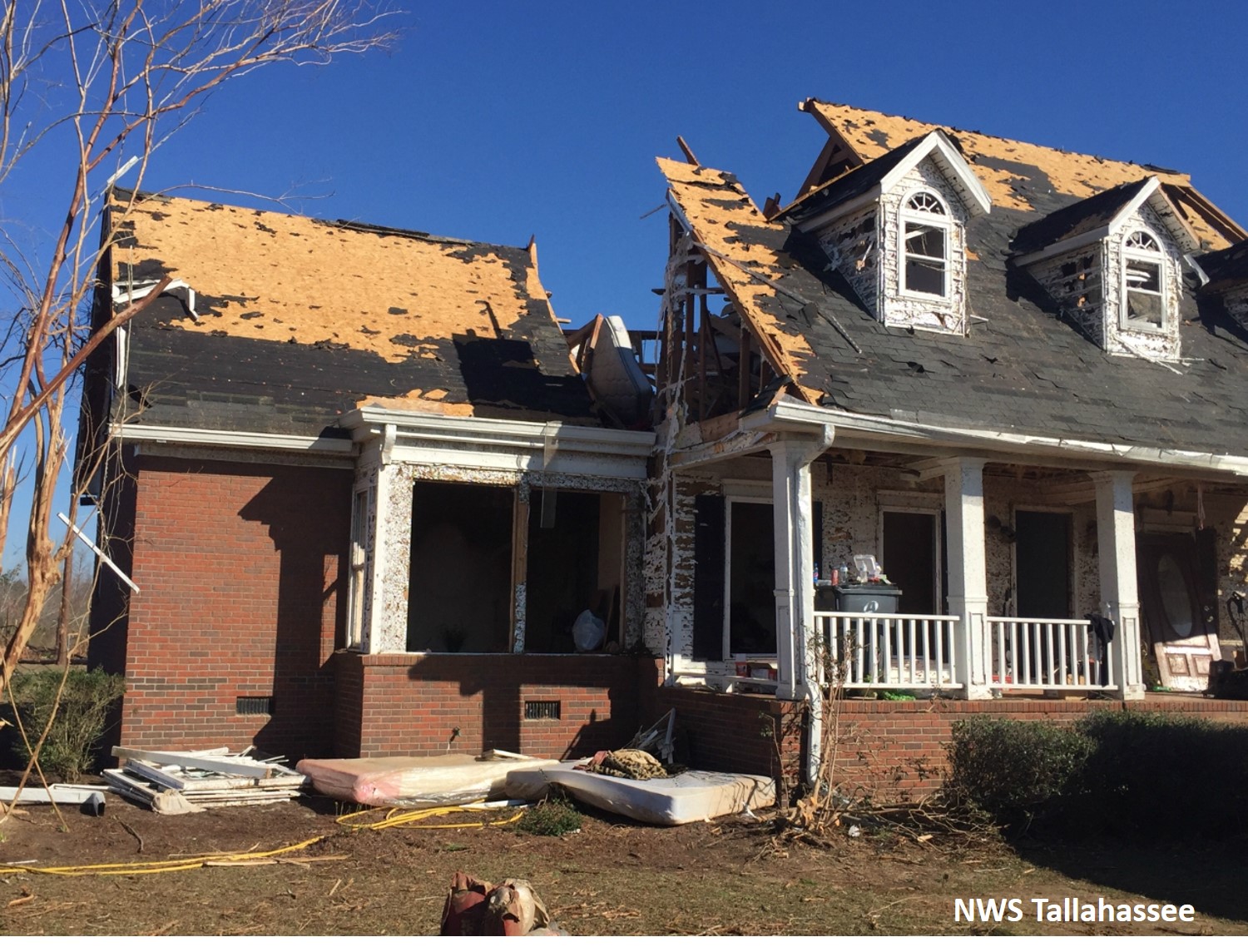
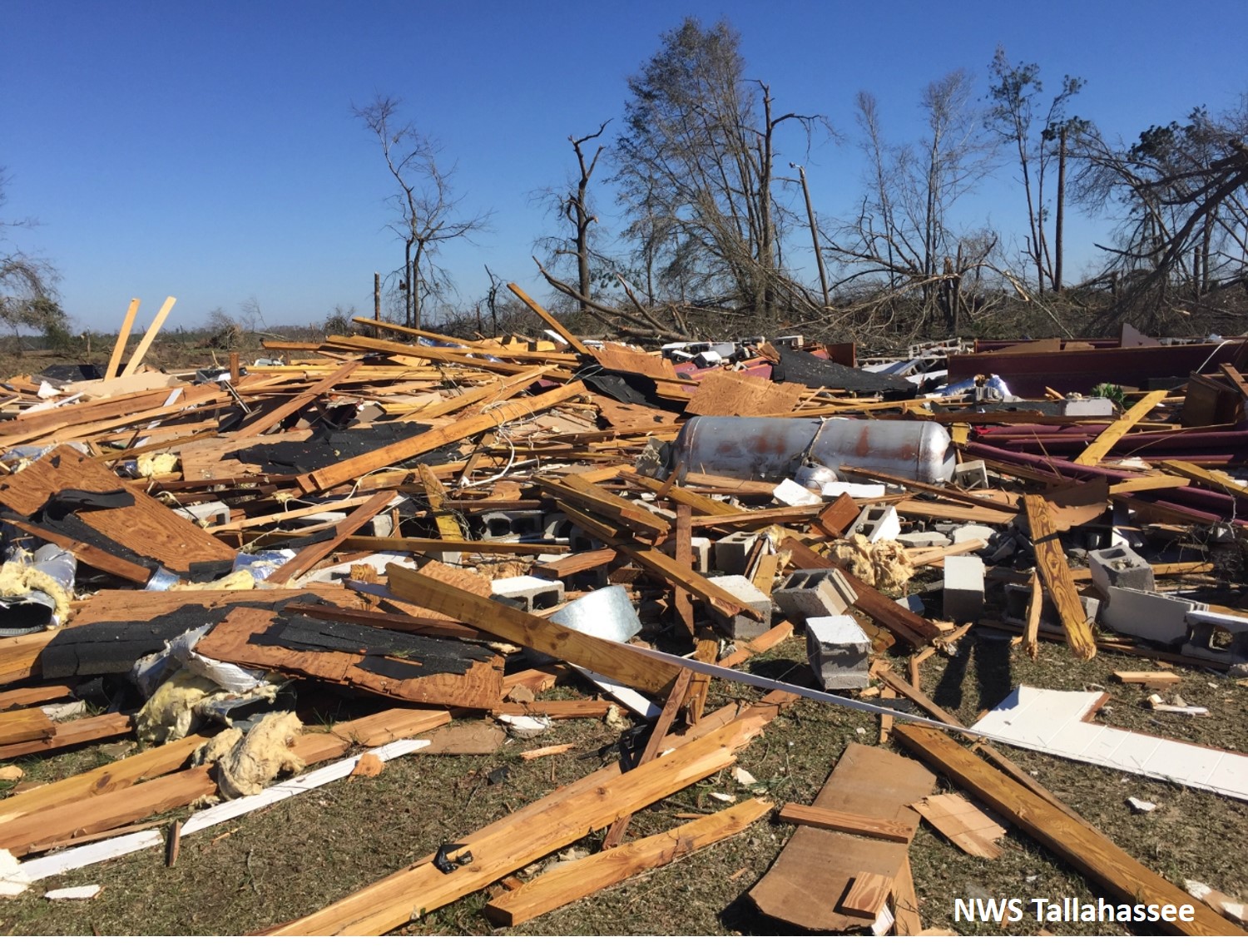
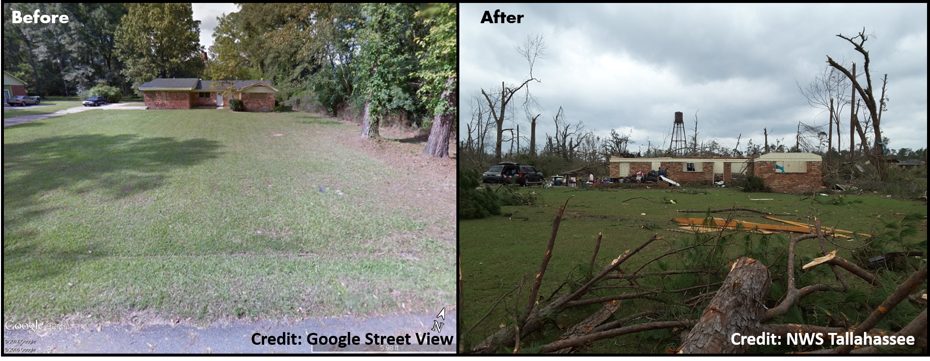
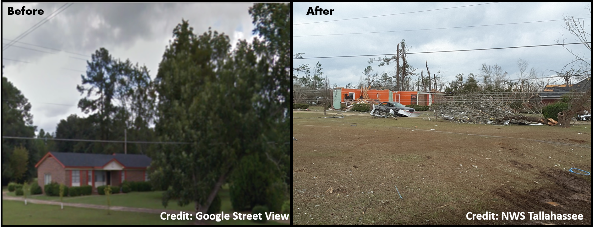
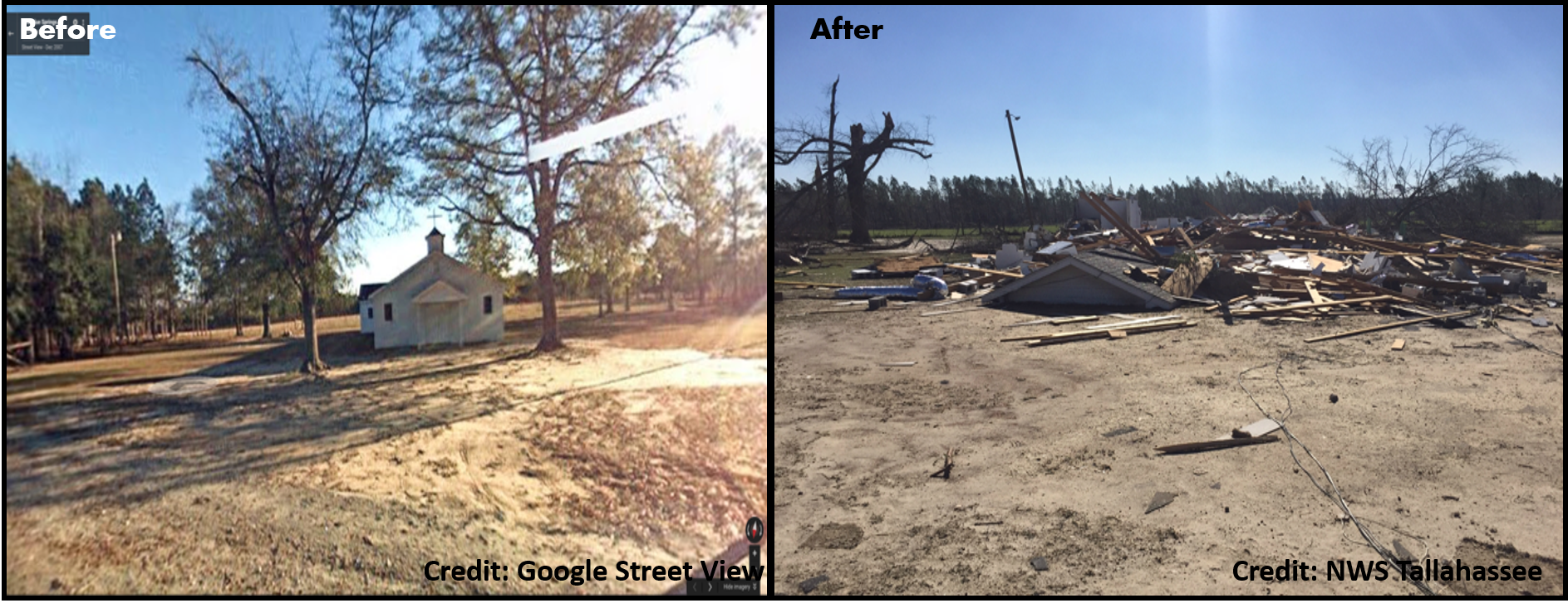
Large long-track tornado touched down near Dougherty/Baker Co. line and travelled over 70 miles across Dougherty, Worth, Turner, and Wilcox Counties in South Georgia. The tornado lifted just east of Abbeville. The tornado caused significant damage along the track, resulting in 4 fatalities in Albany. Severe tree damage was observed along the entire path which was up to 1.2 miles wide. In many spots, 90 to 100 percent of the trees in the path were uprooted or snapped. In Dougherty County, the tornado touched down on Tarva Road. By the time it reached Newton, the tornado was approximately 1.25 miles wide. There was extensive tree damage and some minor to moderate damage to a few homes in this area, consistent with EF2 damage. The tornado moved through the Radium Springs area, destroying nearly every tree in its path and causing EF2 damage to several houses. Most houses in this area had significant damage from falling trees. The tornado then moved through several mobile home parks just west of U.S. 19, destroying many mobile homes and causing the 4 fatalities. Damage consistent with an EF3 tornado was observed just east of U.S. 19. The tornado caused a large portion of a warehouse at the Proctor and Gamble Plant to collapse and tossed several semi-trailers across Mock Road. Additional EF3 damage was observed at the Marine Corp Logistics Base, where multiple anchored double-wide trailers were completely destroyed. In addition, several concrete light poles were snapped near the base, and a large solid concrete building had its solid concrete roof shifted more than 2 inches. A well-built concrete block church on Sylvester Rd was demolished with only parts of a few walls remaining. The estimated wind speed at this point is 150 mph, the highest analyzed along the track. EF3 damage was also observed on Harris Road where a cement block church was destroyed. The tornado then entered Worth County and caused extensive damage to homes along Jewel Crowe Road. This was consistent with EF3 damage. Damage to homes and outbuildings consistent with EF2 damage was observed along Camp Osborn Road. A concrete block church on Zion Church Road was completely destroyed, justifying an EF3 rating at that point. The tornado entered Turner County along and north of Son Story Road. Damage to a frame home along Ireland road was consistent with EF3 damage. Additional EF2 damage was found along this road. There was also some evidence for multiple vortices near the intersection of Ireland Road and U.S. 41. Additional EF3 damage was observed on King Burgess Circle where a large frame house was severely damaged and multiple mobile homes were destroyed. The tornado continued northeast across Interstate 75 causing EF2 damage to several frame homes and mobile homes. Tree damage diminished as the tornado approach the Wilcox county line, suggesting that the tornado temporarily weakened. The tornado continued its track into extreme southeast Crisp County and southwest Wilcox County. Damage was seen off Double Run Road (CR 42) and CR 41 where a small farm building was completely destroyed. Windows were broken at two residences and several small trees were uprooted. Just northeast, significant damage occurred along Crawford Dairy Road between July Road and Loblolly Road. A metal building structure was significantly damaged with the several anchored metal trusses completely pulled off the concrete foundation, resulting in a total collapse of the building. Additional farm outhouses/metal barns around the property were severely damaged, and hundreds of pines were flattened (snapped near their base) or uprooted. Farther along Crawford Dairy Road, just before SR 233, several large wooden electrical transmission towers were snapped (near the base) or leaning. The width of the tornado around this location is estimated to be at least one half mile. Along American Legion Road, between Bayberry Lane and Elderberry Lane, a large (semi-truck) trailer was flipped, flattened and moved across a road. One (southeast) corner of a metal building structure was completely destroyed with 2+ foot (deep) concrete support beams ripped out of the ground. Numerous large trees were snapped near their bases around this location. A small home nearby sustained minor roof and siding damage. At this location, winds estimated to be 110-120 MPH, putting into an EF-2 category. Moving northeast along Willingham road, trees were snapped or uprooted. As the tornado went over Mount Olive Road, just south of Highway 280, several single, and double-wide manufactured homes were completely destroyed. Debris was moved 50-100 yards away from the original foundations. Based on this damage, the tornado may have briefly strengthened to around 135 MPH, but a large house just up the hill from this location only sustained minor roof damage. Additionally, trees around the manufactured home remained standing. These reasons increased the survey teams confidence to maintain the tornado at EF-2 strength in this area. The tornado crossed Highway 280 leveling numerous trees and destroying several small wooden sheds/barns. From this point, the tornado and parent supercell appeared to weaken considerably, with only some trees snapped or uprooted seen along Kingfisher Road, just west of Abbeville. No other damage was seen beyond Kingfisher and Harvey Road. |
 |
 |
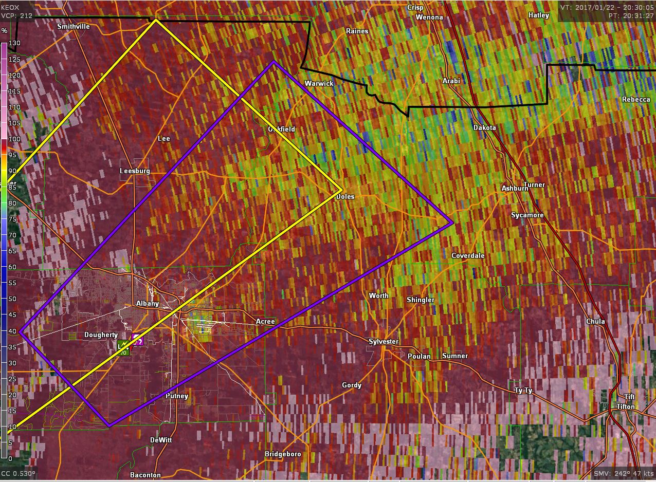 |
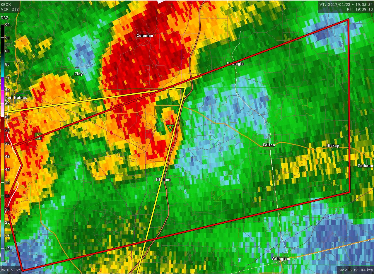
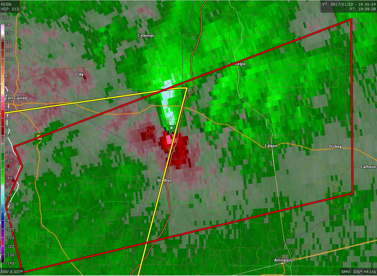
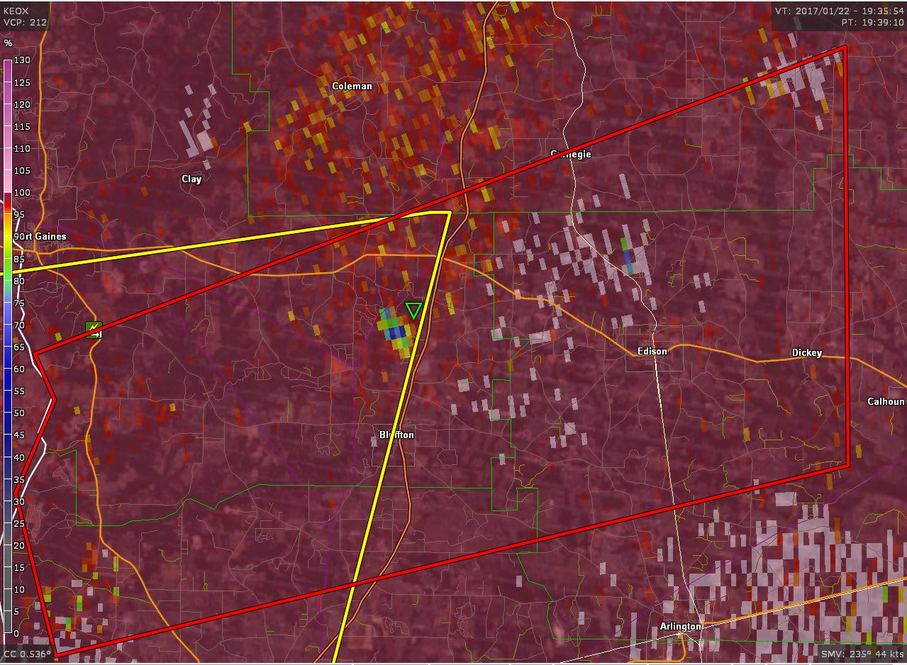
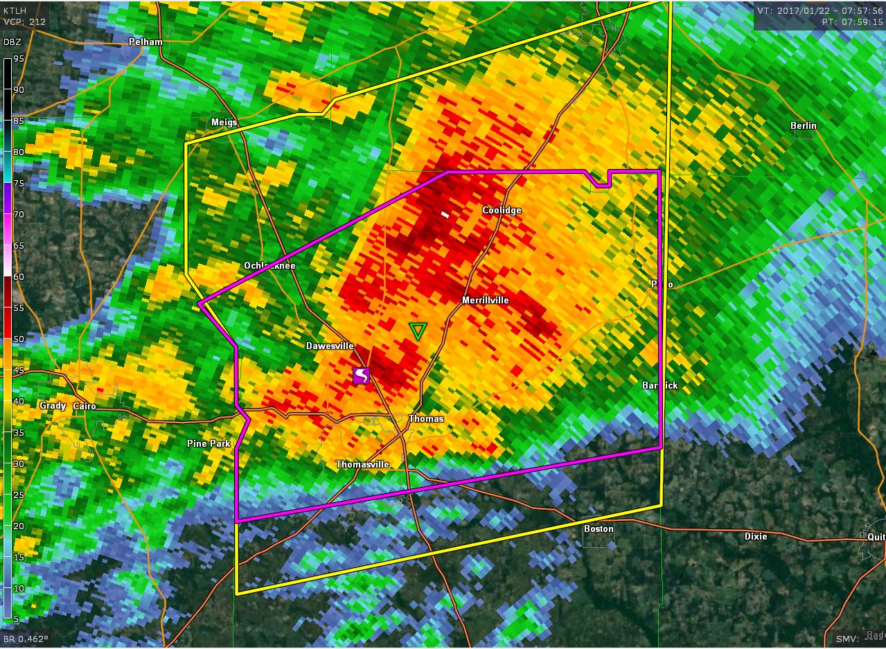
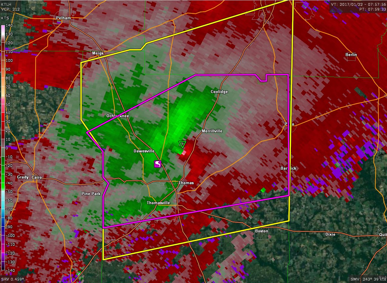
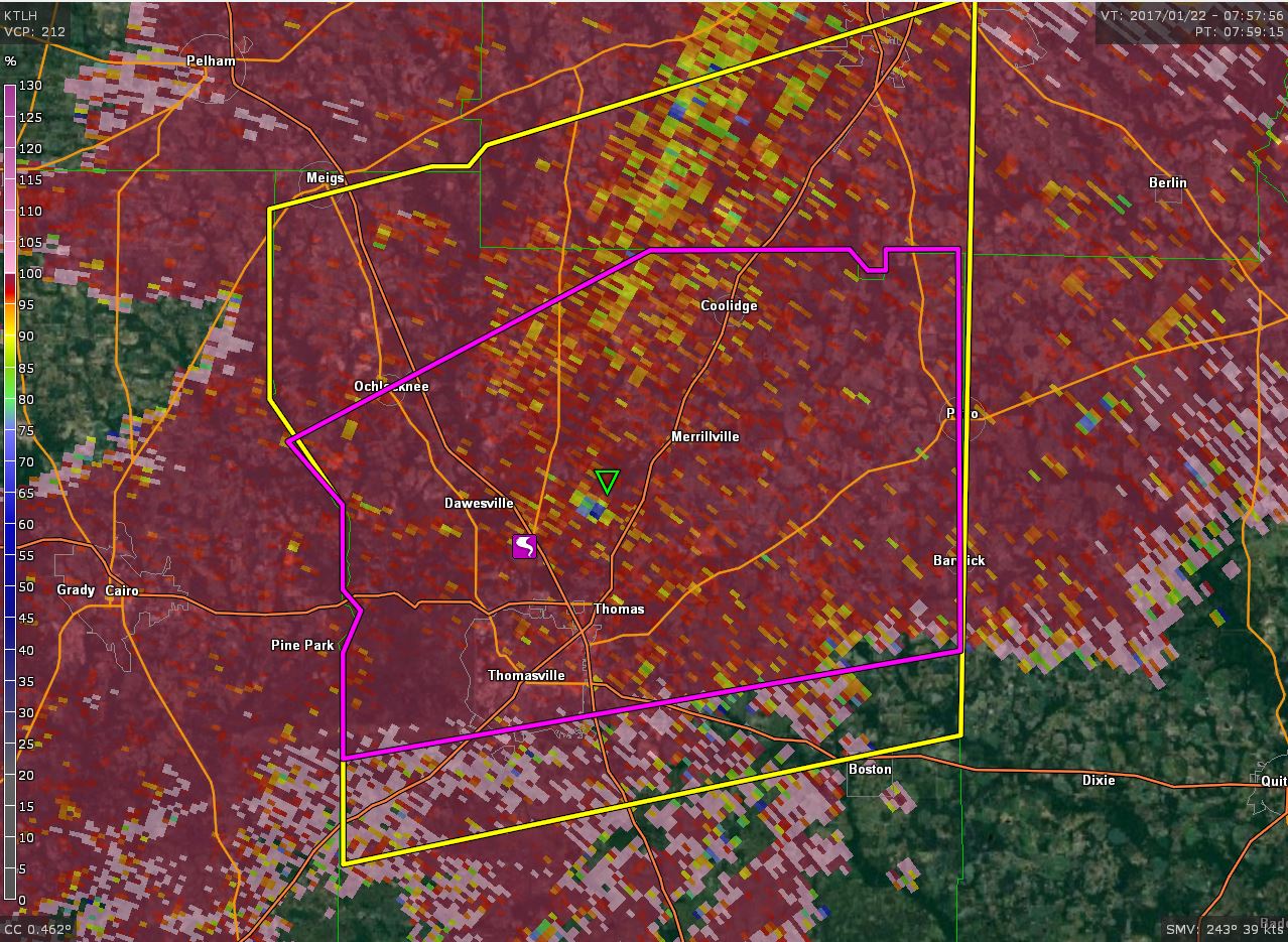
| Reflectivity image in Dougherty County | Velocity image in Dougherty County | Correlation coefficient image in Dougherty County |
 |
 |
 |
| Dougherty County building destroyed by tornado | Major damage to a home in Dougherty County | Church in Worth County destroyed by tornado |
 |
 |
| Damage on Camellia Road in Albany | Damage on Holly Drive in Albany |
 |
 |
| Damage on Holly Drive in Albany | Church destroyed on North County Line Road |
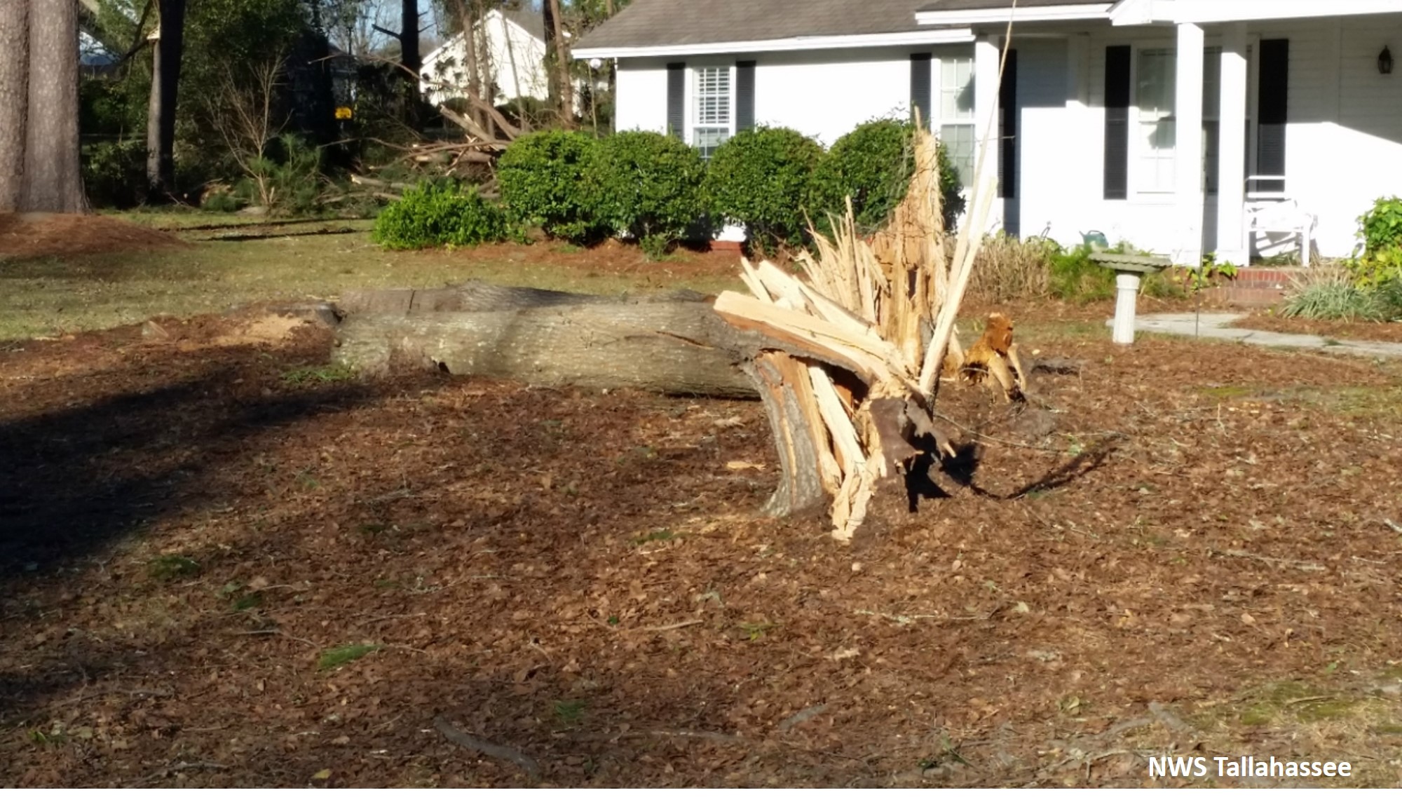
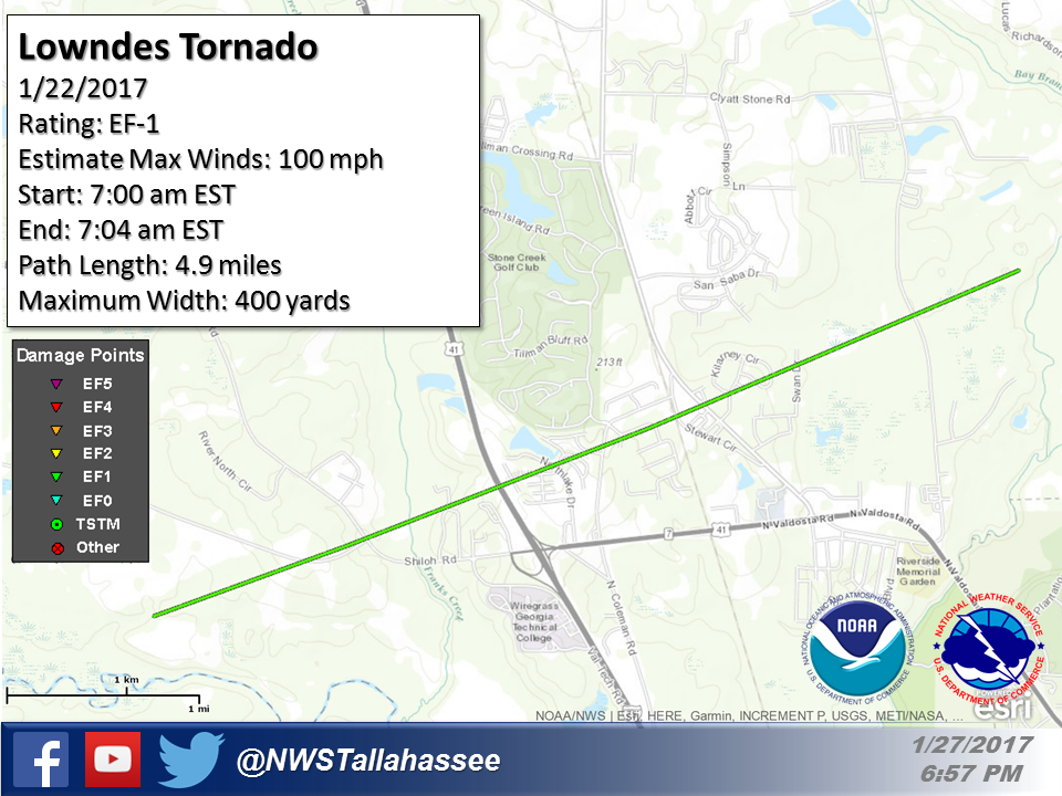
Rating:                 EF1
Estimated Peak Wind:    100 mph
Path Length /statute/:  4.85 miles
Path Width /maximum/:   400 yards
Fatalities:             0
Injuries:               0

Start Date:             01/22/2017
Start Time:             07:00 AM EST
Start Location:         2 WSW I-75 At Exit 22 / Lowndes County /
GA
Start Lat/Lon:          30.8897 / -83.3891

End Date:               01/22/2017
End Time:               07:04 AM EST
End Location:           3 NE I-75 At Exit 22 / Lowndes County /
GA
End Lat/Lon:            30.9158 / -83.3134
|
The tornado initially touched down just east of the Withlacoochee River in Lowndes County and tracked toward Interstate 75. On the west side of the interstate, a few trees were snapped along Shiloh Road. Additionally, billboards along the interstate were also damaged. After crossing Interstate 75, the tornado impacted a subdivision on both the west and east side of North Coleman Road. Damage in this area was primarily limited to minor roof damage. Multiple homes had shingles removed. Additionally several large pines were snapped in the area as well. Damage in this area was consistent with lower end EF-1 damage. As the tornado approached US-41, a large barn was destroyed and several large trees were also uprooted. Several other large trees were uprooted just east of US-41 on Kilarney Circle. Damage in these areas was consistent with an EF-1 tornado with winds around 100 MPH. The tornado snapped a few more pine trees when passing Val Del Road before lifting about 1 mile east of the road. |
 |
 |
| Reflectivity image in Lowndes County | Velocity image in Lowndes County |
 |
 |
| Tree snapped from Lowndes County tornado | Tree uprooted from Lowndes County tornado |
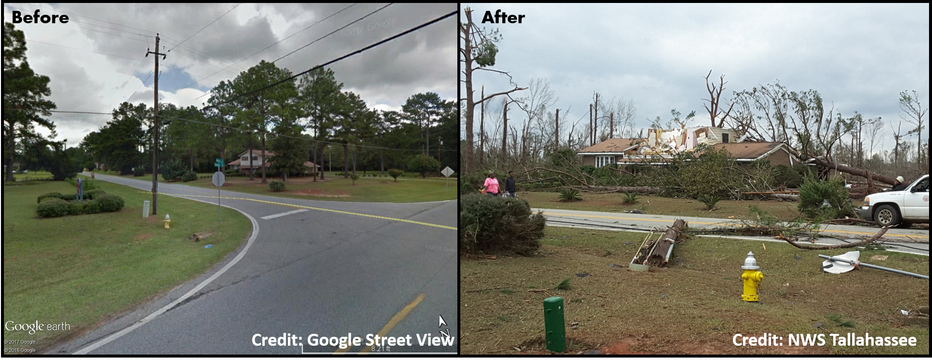
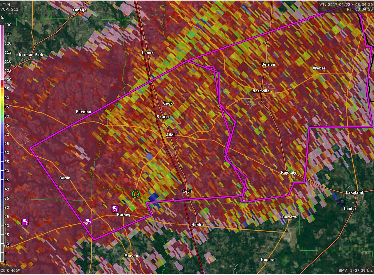
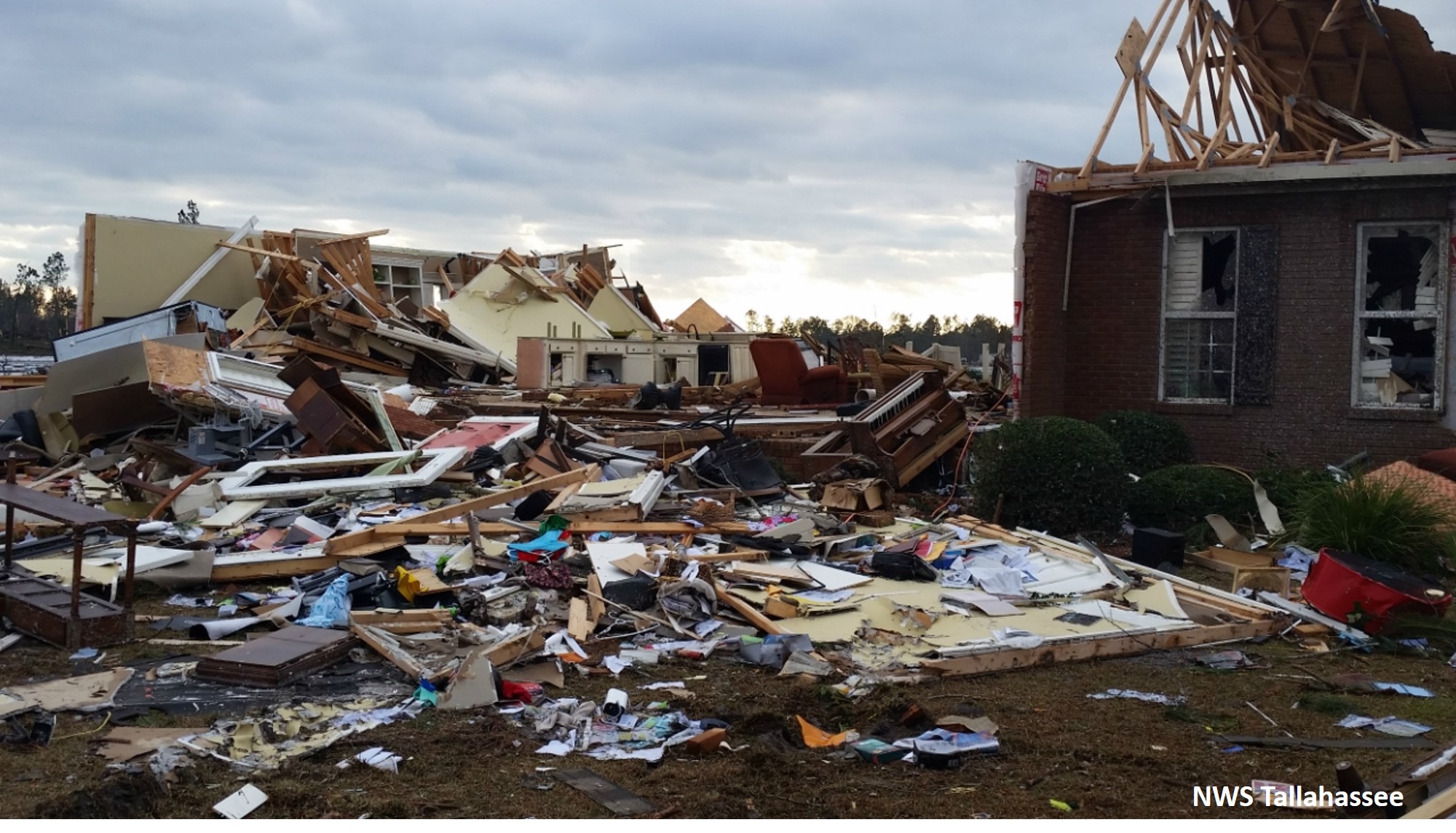
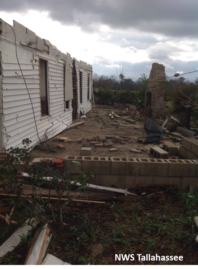
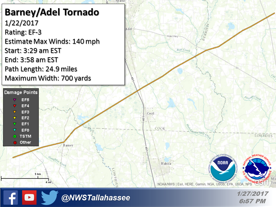
Rating:                 EF3
Estimated Peak Wind:    140 mph
Path Length /statute/:  24.88 miles
Path Width /maximum/:   700 yards
Fatalities:             11
Injuries:               0

Start Date:             01/22/2017
Start Time:             03:29 AM EST
Start Location:         4 ENE Sand Hill / Brooks County / GA
Start Lat/Lon:          30.9998 / -83.5841

End Date:               01/22/2017
End Time:               03:58 AM EST
End Location:           2 N Allenville / Berrien County / GA
End Lat/Lon:            31.1557 / -83.2095
|
This was the second tornado to touch down from the same parent tornado that impacted Thomas and northwest Brooks Counties. The tornado touched down at EF-1 strength in northern Brooks County near Georgia Route 122 just west of the Moultrie Highway, snapping trees along the highway. Near the intersection of Georgia Route 133, or the Valdosta Highway, the tornado strengthened to EF-3 blowing out two of the four concrete walls of a small business building. A short distance later, the tornado flipped a strapped-down double wide mobile home and tossed it about 100 feet into a drainage ditch and across Route 122. Two people inside the home were killed. Several nearby trees had their bark stripped off. The tornado then crossed Georgia Route 76 at EF-3 strength and ripped about a third of the second story from a well- built brick home. A short distance up the road, the tornado shifted a wood-framed home about 12 feet off its foundation while removing its second story. |
 |
 |
 |
| Reflectivity image in Brooks County | Velocity image in Brooks County | Correlation coefficient image in Brooks County |
 |
 |
| Home destroyed in Berrien County | Home that slide off its foundation in Brooks County |
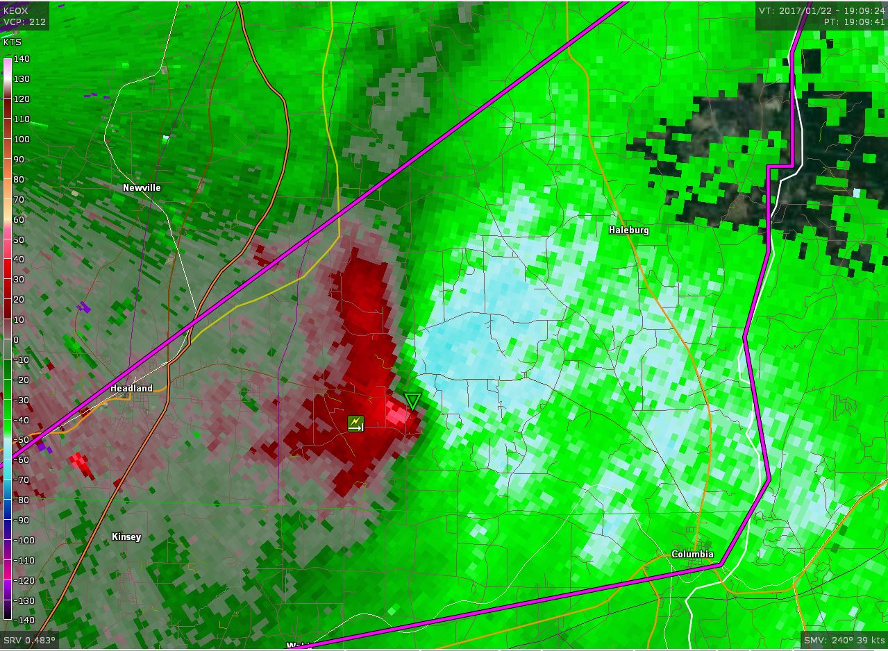
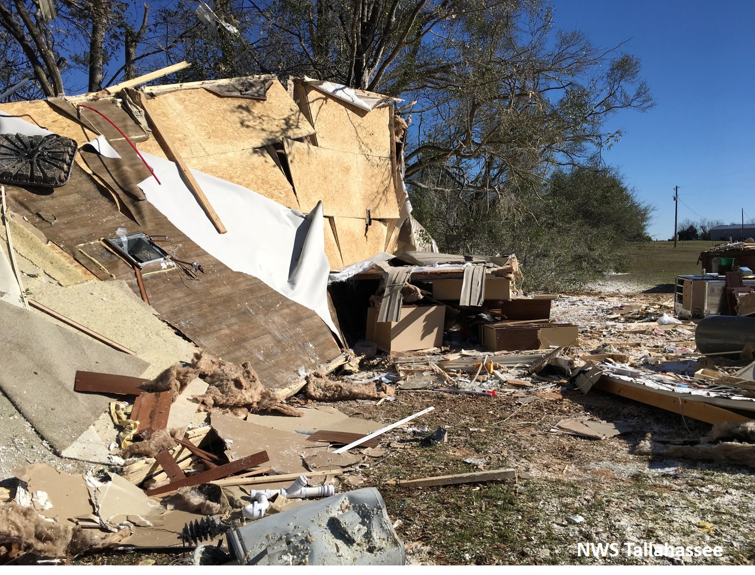
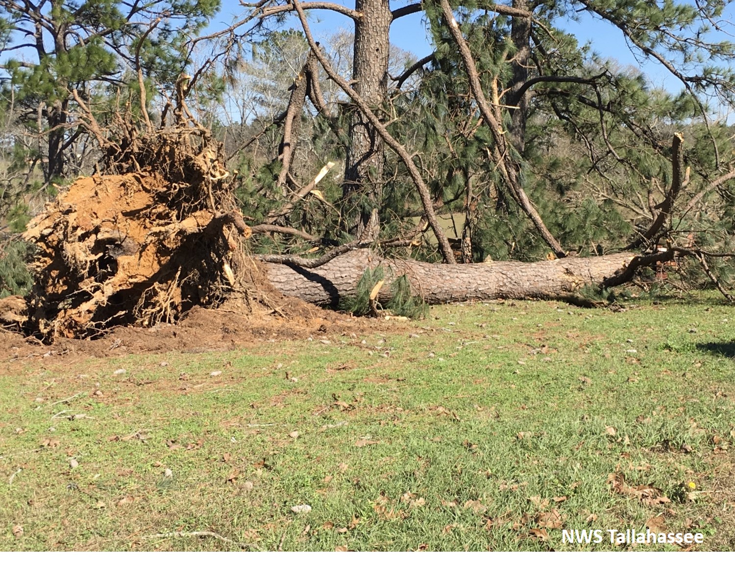
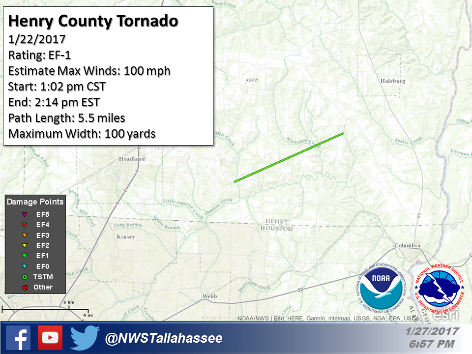
Rating:                 EF1
Estimated Peak Wind:    110 mph
Path Length /statute/:  5.53 miles
Path Width /maximum/:   100 yards
Fatalities:             0
Injuries:               0

Start Date:             01/22/2017
Start Time:             02:02 PM EST
Start Location:         2 SW Grandberry Crossroads / Henry County / AL
Start Lat/Lon:          31.3377 / -85.2515

End Date:               01/22/2017
End Time:               02:14 PM EST
End Location:           3 SSW Haleburg / Henry County / AL
End Lat/Lon:            31.3706 / -85.1662
|
EF1 tornado tracked across southern Henry County snapping and uprooting numerous trees, destroying a mobile home and causing minor roof damage to a few structures. |
 |
 |
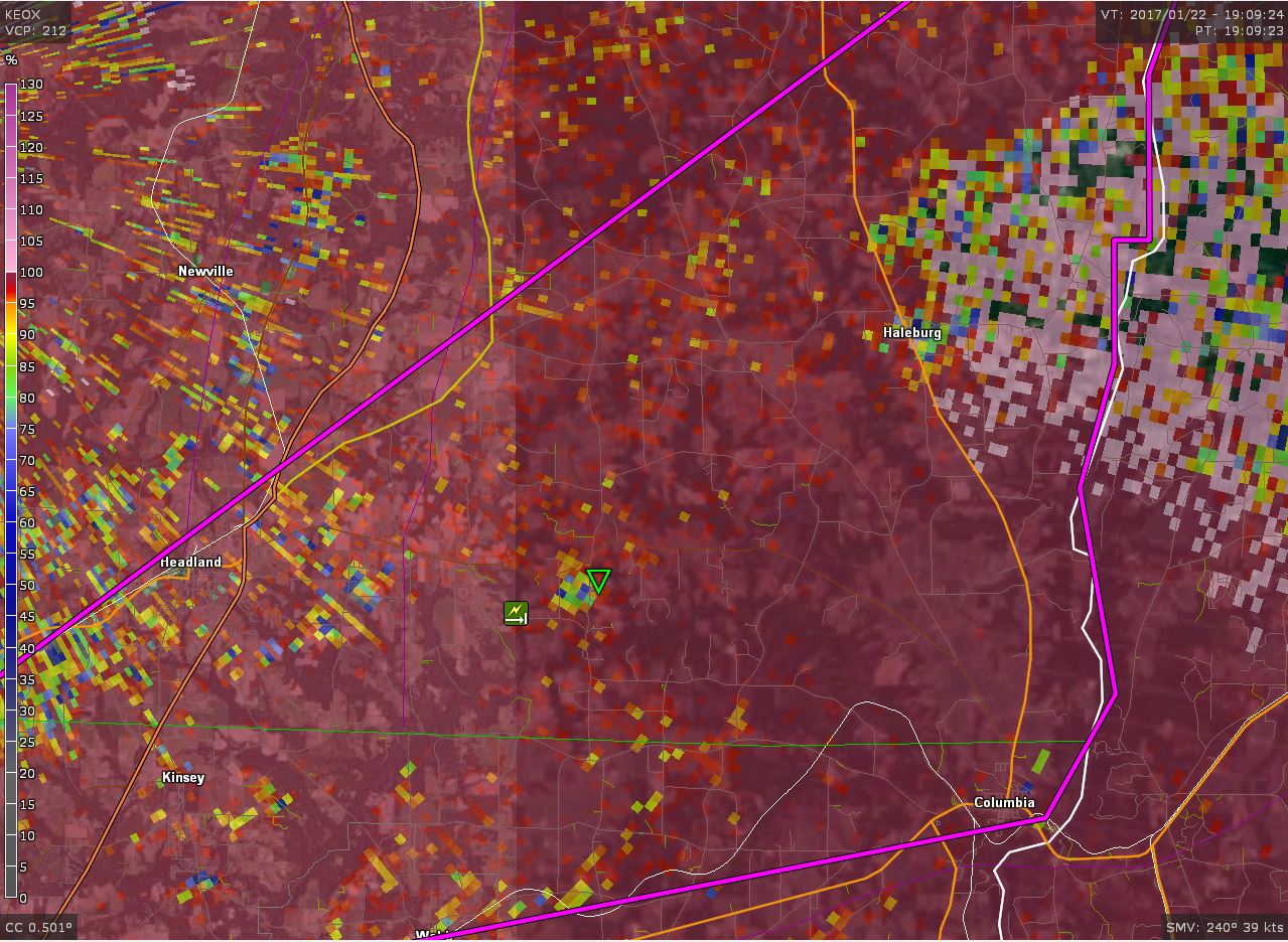 |
| Reflectivity image in Henry County | Velocity image in Henry County | Correlation coefficient image in Henry County |
 |
 |
| Mobile home in Henry County was flipped and destroyed while residents took shelter in a near by home |
Tree uprooted from the Henry County tornado |
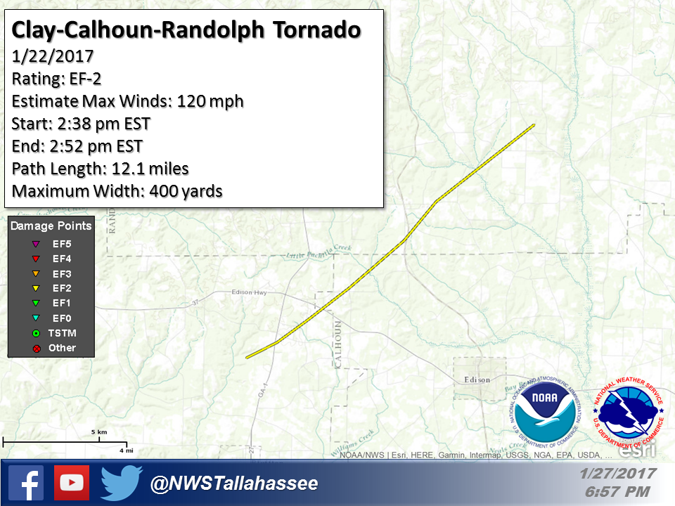
Rating:                 EF2
Estimated Peak Wind:    125 mph
Path Length /statute/:  12.07 miles
Path Width /maximum/:   400 yards
Fatalities:             0
Injuries:               1

Start Date:             01/22/2017
Start Time:             02:38 PM EST
Start Location:         2 NNE Harrisons Mill / Clay County / GA
Start Lat/Lon:          31.5704 / -84.8654

End Date:               01/25/2017
End Time:               02:52 PM EST
End Location:           1 S Goffs Mill / Randolph County / GA
End Lat/Lon:            31.6805 / -84.7076
|
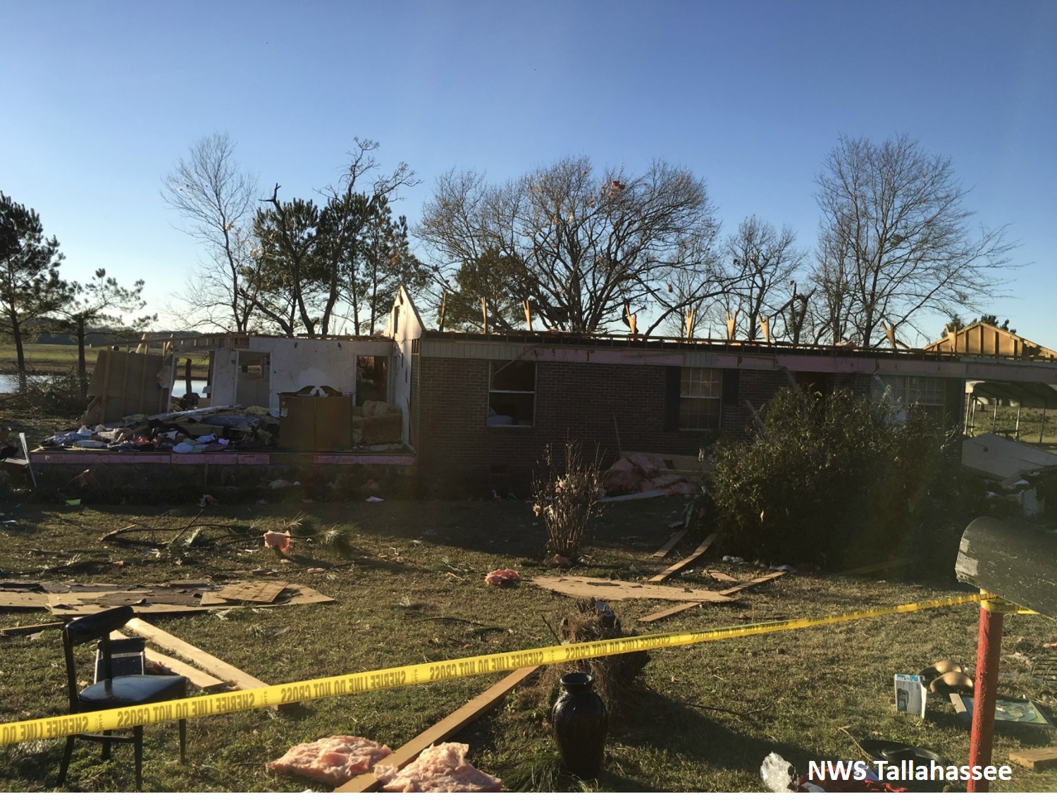
The tornado touched down in Clay County and moved northeast through the northwest corner of Calhoun County and into southern Randolph County. It caused extensive tree damage with nearly every tree in its path snapped through the Clay and Calhoun portions of the track. In addition, it flipped a mobile home in Clay County, injuring one person who was inside. The tornado caused major roof damage in Clay and Calhoun counties removing the roofing structure from two homes. It also caused minor roofing damage to several homes in all three counties. |
 |
 |
 |
| Reflectivity image in Clay County | Velocity image in Clay County | Correlation coefficient image in Clay County |
 |
 |
| Roof and addition of a brick home destroyed by the tornado |
Mobile home destroyed by the tornado in Calhoun County |
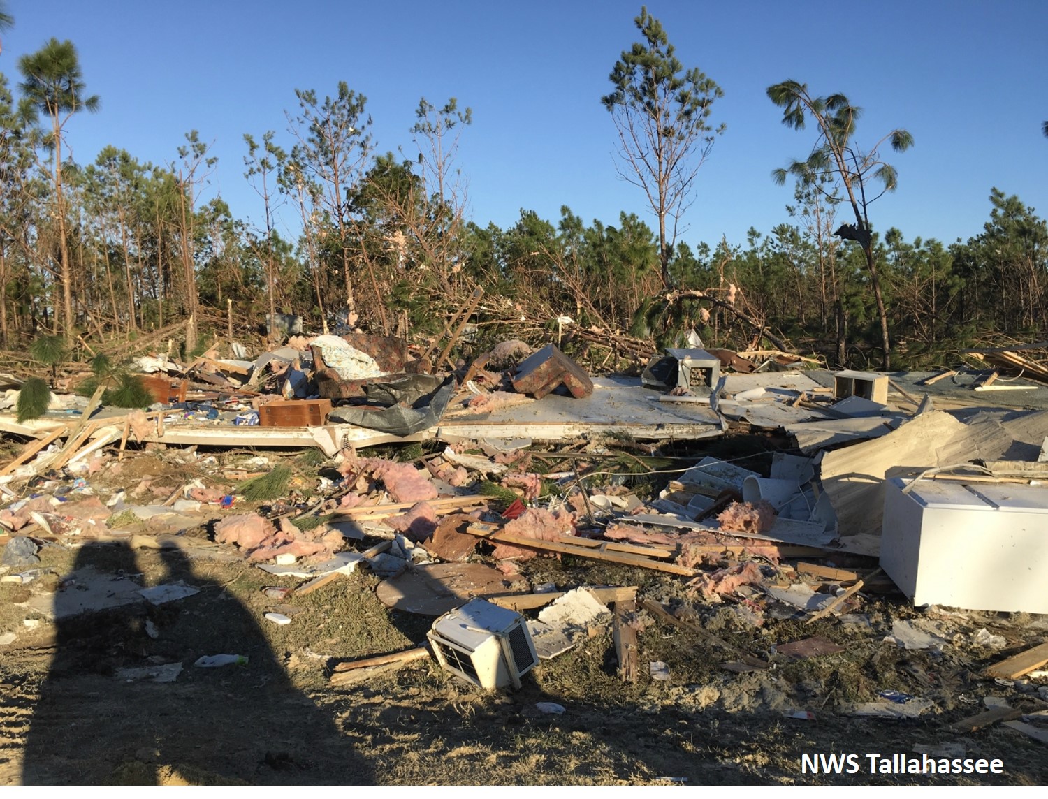
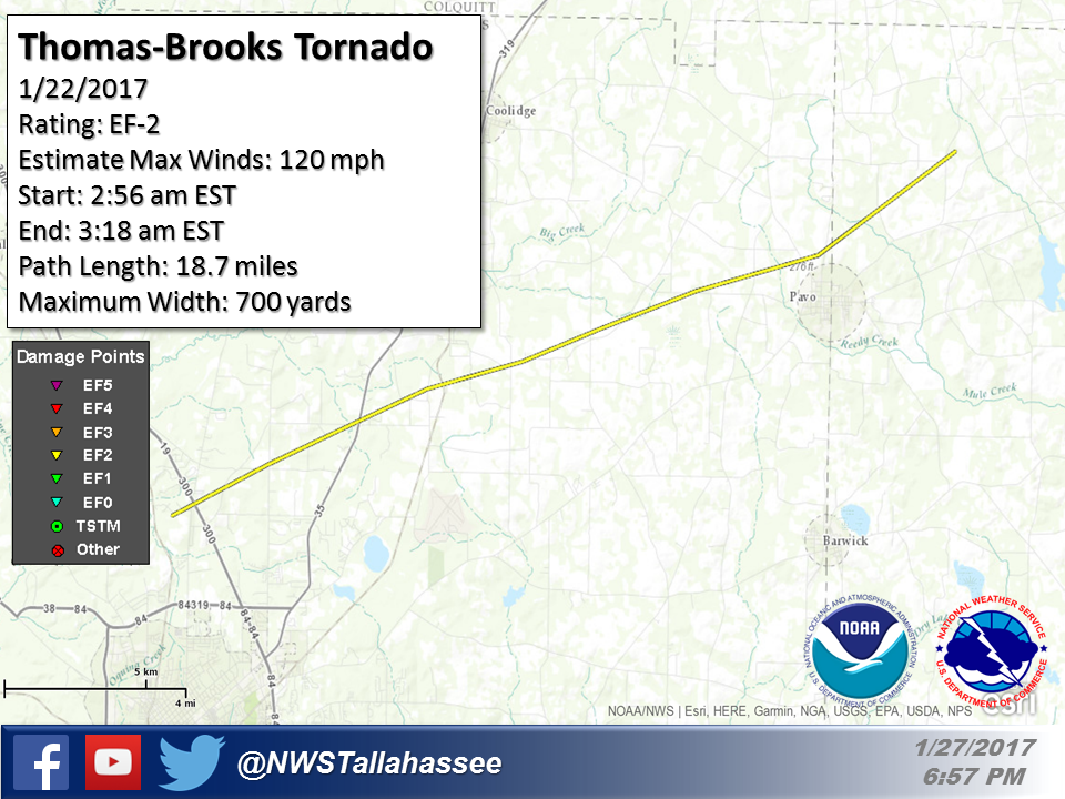
Rating:                 EF2
Estimated Peak Wind:    120 mph
Path Length /statute/:  18.74 miles
Path Width /maximum/:   700 yards
Fatalities:             0
Injuries:               3

Start Date:             01/22/2017
Start Time:             02:56 AM EST
Start Location:         1 S Pasco / Thomas County / GA
Start Lat/Lon:          30.8997 / -83.9821

End Date:               01/22/2017
End Time:               03:18 AM EST
End Location:           3 WNW Sand Hill / Brooks County / GA
End Lat/Lon:            31.0016 / -83.6917
|
This tornado was the first of two produced by the same thunderstorm that moved across South Georgia early Sunday morning. The tornado initially touched down just west of US-19 in Thomas County and then moved NE across mainly rural areas of the county. Damage was initially limited in the vicinity of US-19 to snapped and uprooted pine trees. The tornado began to strengthen and produced more significant damage near the vicinity of Crowley and Hall Roads where a home lost a significant amount of roof deck and numerous large trees were snapped and uprooted. Damage in this area was consistent with higher end EF-1 to lower end EF-2 intensity. |
 |
 |
 |
| Reflectivity image in Thomas County | Velocity image in Thomas County | Correlation coefficient image in Thomas County |
 |
 |
| Home in Thomas County damaged by tornado | Pine trees snapped from Thomas County tornado |
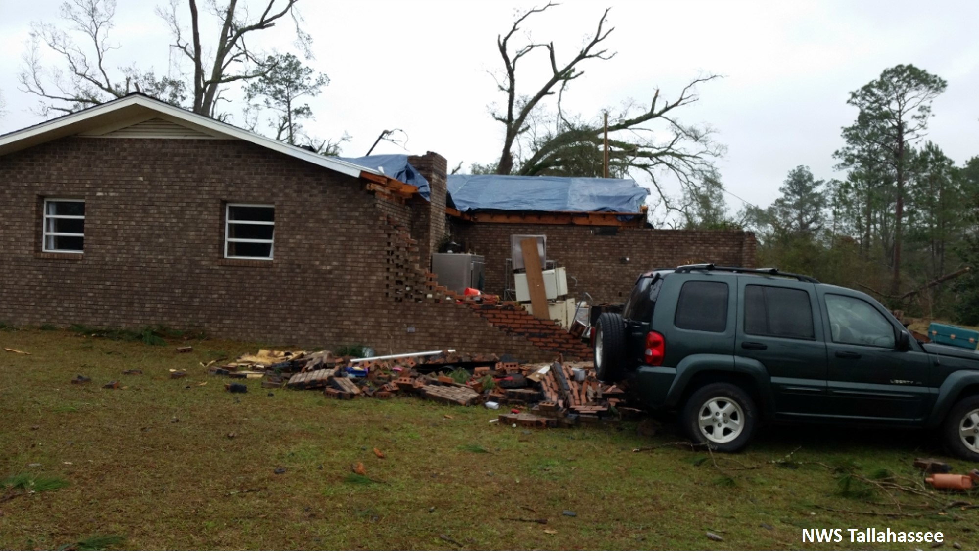
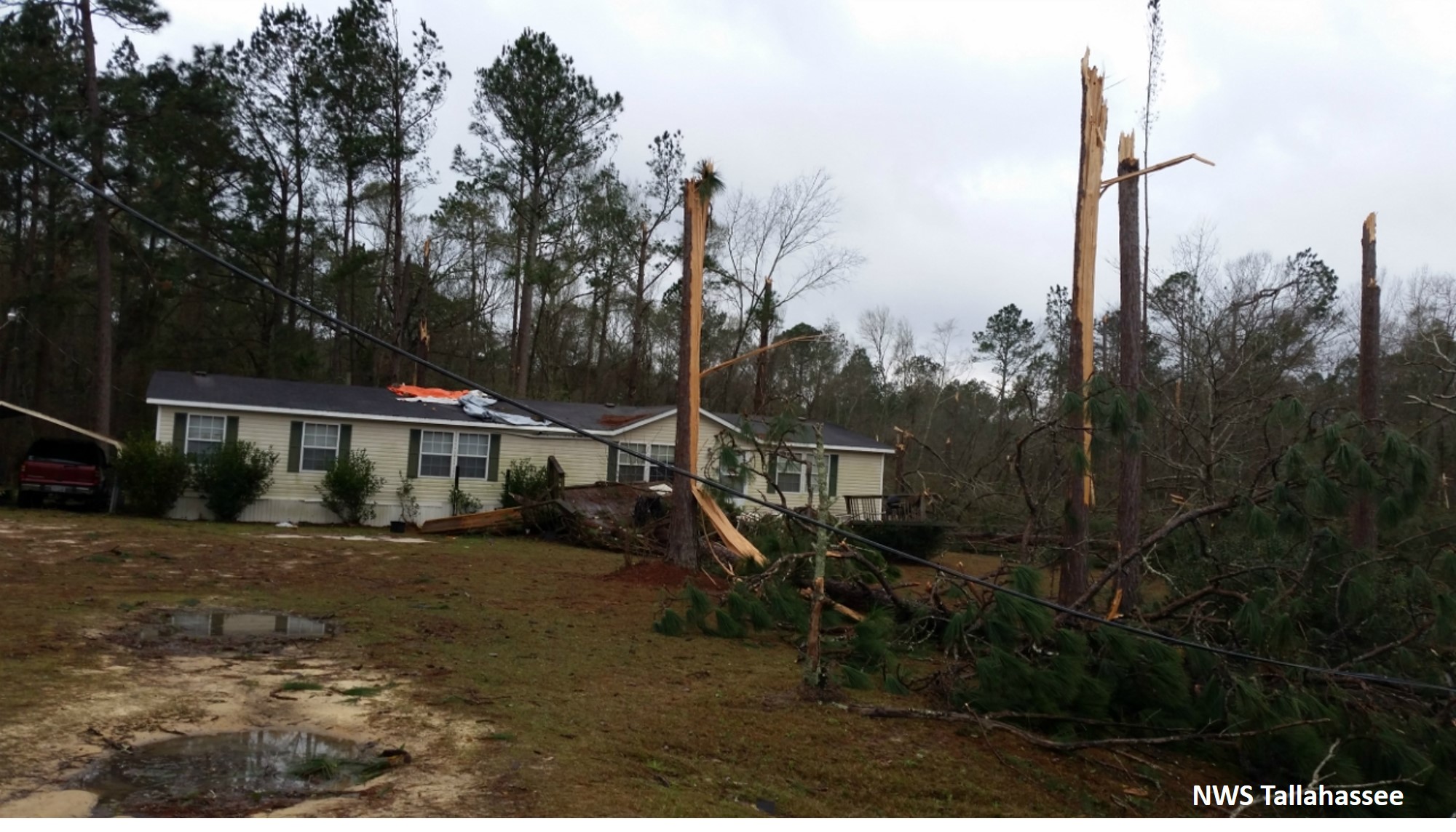
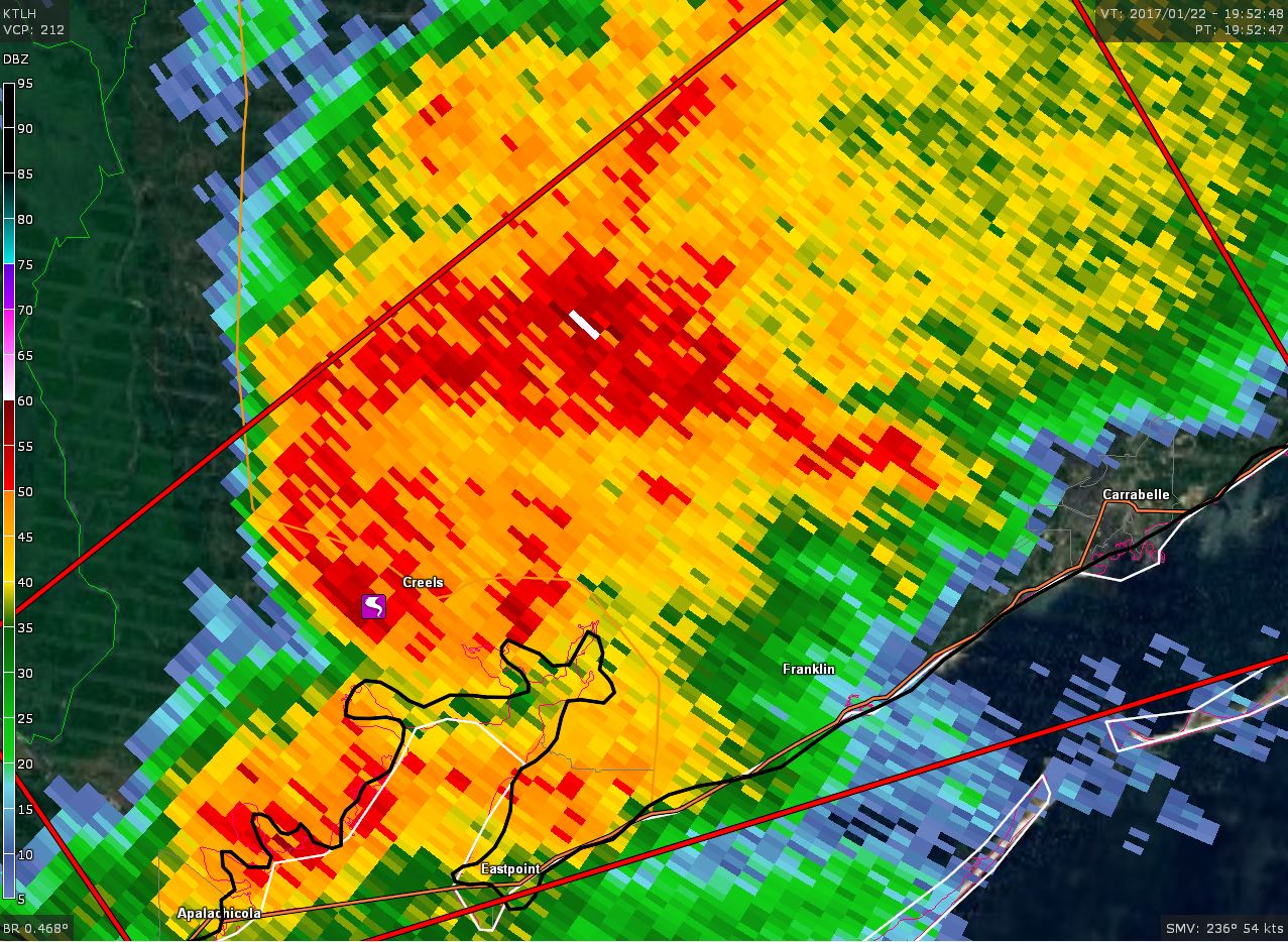
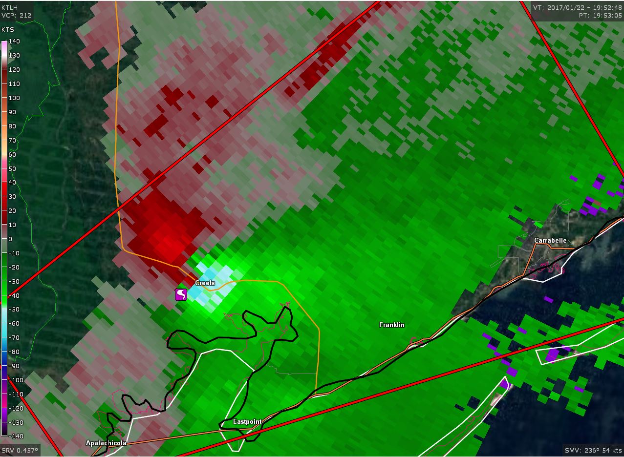
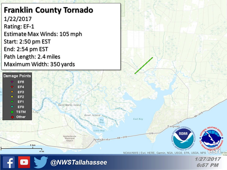
Rating:                 EF1
Estimated Peak Wind:    105 mph
Path Length /statute/:  2.35 miles
Path Width /maximum/:   350 yards
Fatalities:             0
Injuries:               0

Start Date:             01/22/2017
Start Time:             02:50 PM EST
Start Location:         1 W Creels / Franklin County / FL
Start Lat/Lon:          29.8217 / -84.9188

End Date:               01/22/2017
End Time:               02:54 PM EST
End Location:           2 NNE Creels / Franklin County / FL
End Lat/Lon:            29.8449 / -84.89
|
Across rural Franklin County, a tornado touched down just west of SR-65 on the north side of East Bay. This tornado tracked across SR-65 before dissipating prior to reaching Juniper Creek Road. Damage along the path of the tornado was limited to snapped or uprooted pine trees. Damage along the track was consistent with an EF-1 tornado with maximum winds of 105 mph. |
 |
 |
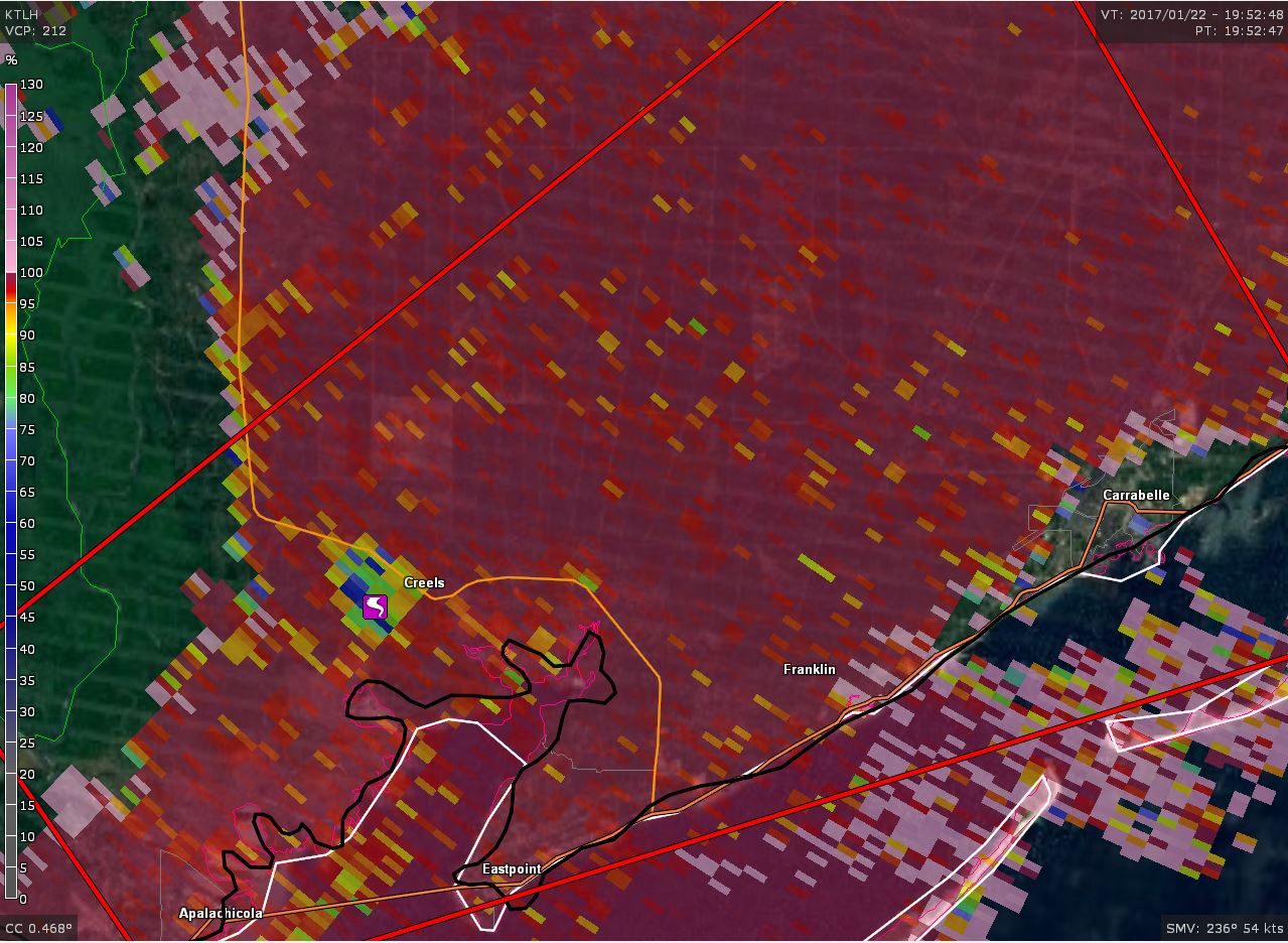 |
| Reflectivity image in Franklin County | Velocity image in Franklin County | Correlation coefficient image in Franklin County |
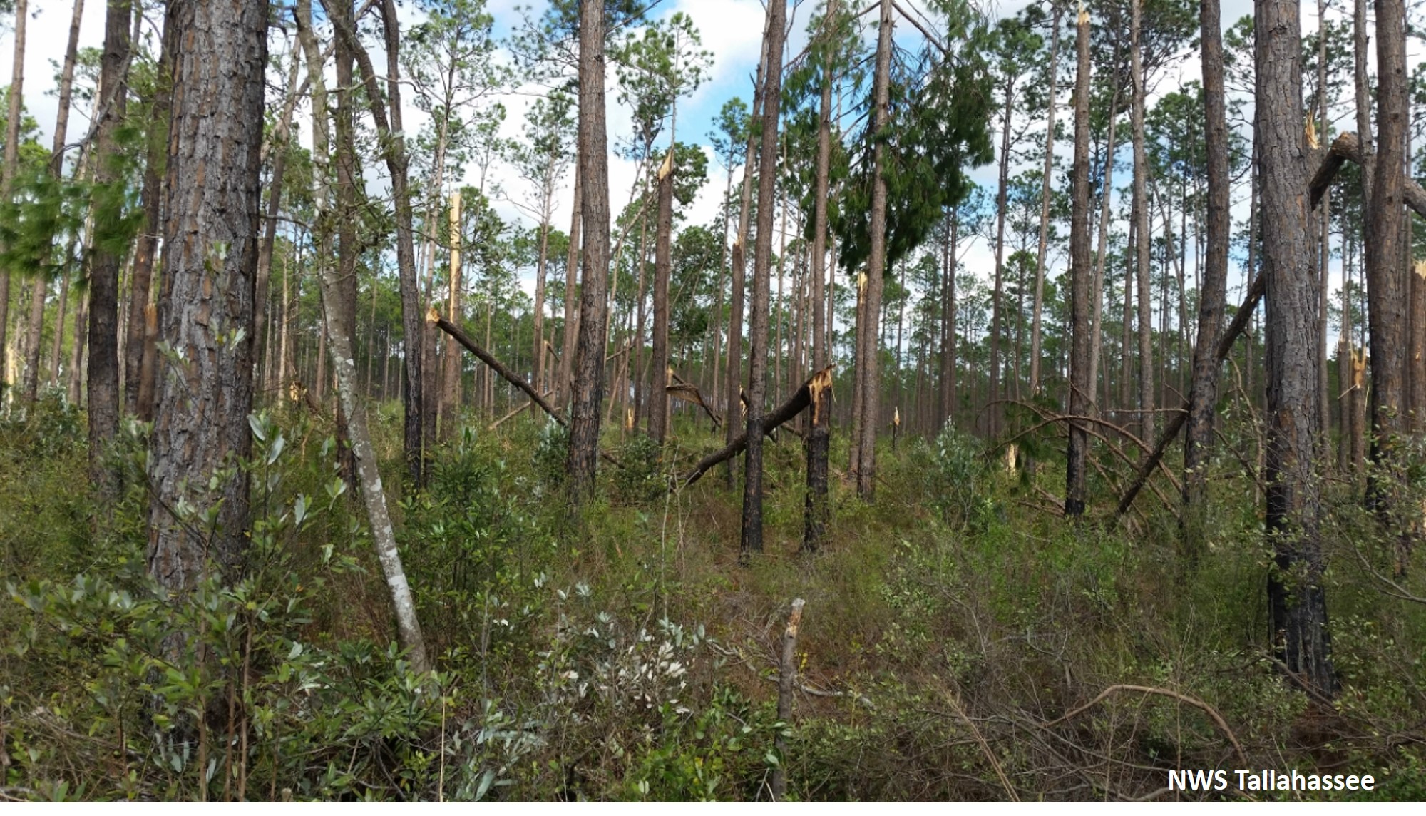 |
| Trees snapped from the Franklin County tornado |


 Follow us on YouTube