Hurricane Irma Synopsis
Hurricane Irma was a classic Cape Verde hurricane that will long be remembered for its severity and wide-ranging impacts to several islands in the Caribbean Sea and Florida. Like many of the most notorious Atlantic hurricanes, Irma began as a weak wave of low pressure accompanied by disorganized showers and thunderstorms which emerged off the west African coast on August 27th, near the peak of the Atlantic hurricane season (Fig. 1). Such disturbances move off the African coast every few days during August and September, however, most of them fail to develop into tropical cyclones. This can be due to a number of factors, including blasts of dry, stable air from the Saharan desert, strong upper-level westerly winds, or a lack of the necessary atmospheric “spin” needed to generate a counterclockwise circulation.
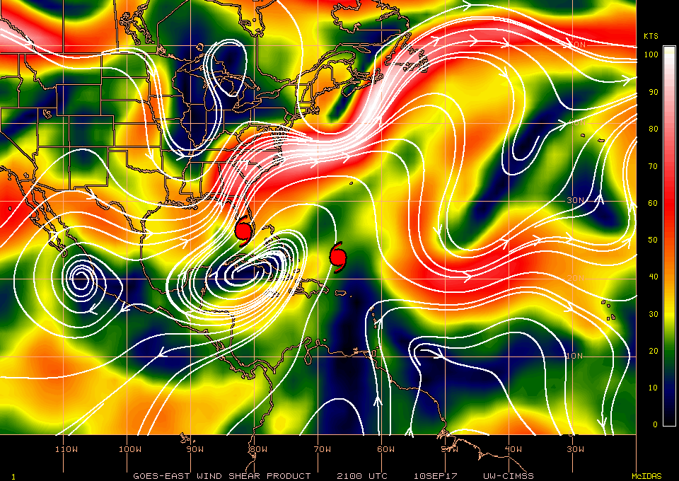
In late August and early September, however, the atmospheric and oceanic conditions in the tropical Atlantic were favorable for tropical cyclone development. Sea surface temperatures were above average (generally in the lower to mid 80s F across the tropical Atlantic), and there was an area of light winds in the upper atmosphere, which allowed the developing storm circulation to grow vertically deep (Fig. 2).
 |
| Fig. 1 National Hurricane Center’s 5-day forecast probability for a tropical disturbance emerging off the west African coast on August 27th. Image courtesy of NHC. |
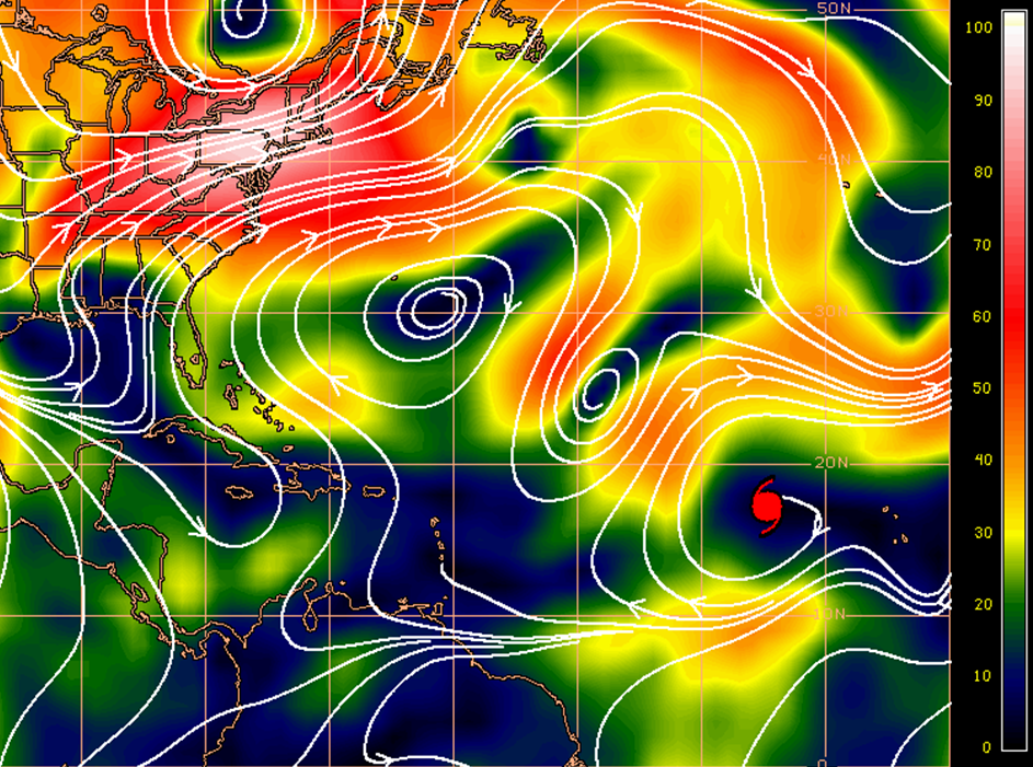 |
| Fig. 2 Upper-level flow (white lines with arrows), based on satellite estimates of 200 mb winds (40,000 ft AGL). Image is vertical wind shear in knots, with black and dark blue being most favorable for tropical cyclone intensification (i.e. light wind shear). Hurricane Irma shown using red hurricane symbol. Image courtesy of UW CIMSS. |
Tropical Storm Irma formed in the far eastern Atlantic Ocean, just west of the Cape Verde Islands, on the morning of August 30th. Over the following 30 hours Irma intensified into a major hurricane with highest sustained winds of 115 MPH, a category-3 storm on the Saffir-Simpson Hurricane Wind Scale. Such rapid strengthening is unusual for storms in the far eastern Atlantic. Irma’s intensity remained fairly steady for the next few days while moving into a region with drier air aloft (Fig. 3)
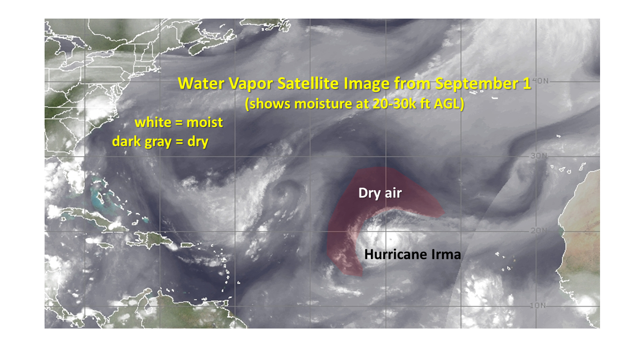 |
| Fig. 3 Water vapor image. Image courtesy of UW CIMSS. |
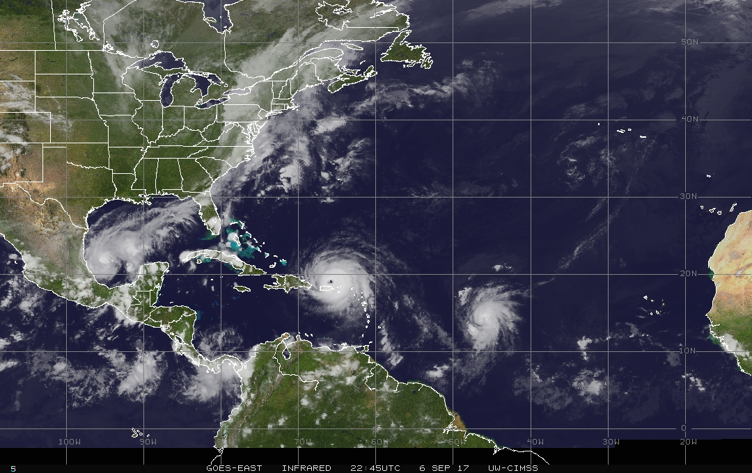
As Irma began to approach the northern Leeward Islands on September 4th and 5th, the hurricane rapidly intensified while moving over warmer water and into a more moist atmosphere. The storm became a rare category-5 hurricane on September 5th, with maximum sustained winds of 185 MPH. This made Irma the strongest hurricane ever observed in the open Atlantic Ocean, and one of only 5 hurricanes with measured winds of 185 MPH or higher in the entire Atlantic basin. Over the next few days Irma continued moving west, passing through the northeast Leeward Islands, Virgin Islands, and just north of the islands of Puerto Rico and Hispaniola, while maintaining its category-5 winds. While category-5 hurricanes are rare, it is even more rare for such storms to maintain this status for such a long period of time. Irma was a category-5 hurricane for 3 days (Fig. 4).
 |
| Fig. 4 Satellite montage of Irma using GOES IR images and NHC advisories. Courtesy of UW CIMSS. |
While it will take time to realize all of the impacts from Irma, some were immediately apparent, even from space. Fig. 5 shows the massive defoliation across some of the Virgin Islands which were struck by Irma at peak intensity. The islands, which used to appear green to the special satellite sensor due to their dense coverage of plants and trees, are now brown.
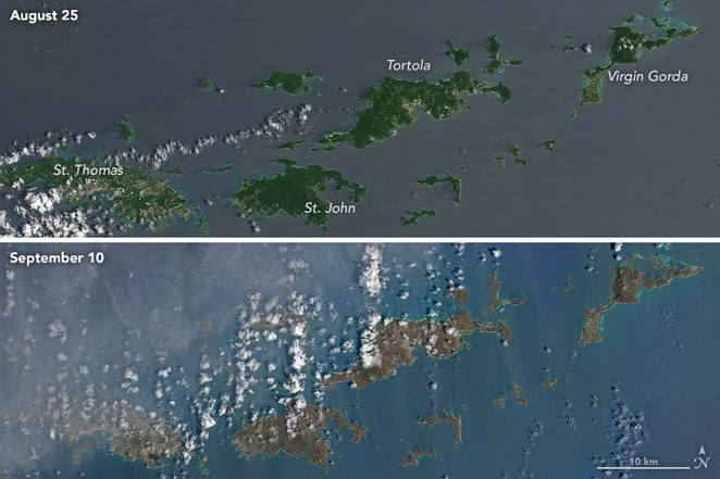 |
| Fig. 5 NASA’s landsat-8 satellite images, before & after Irma. |
The storm finally “weakened” to a category-4 hurricane on September 8th, but still had devastating winds of 155 MPH while moving through the southern Bahamas. Irma intensified to a category-5 level once again that evening, with top winds of 160 MPH, as it approached the northern coast of Cuba. Irma moved west along or just inland from the northern coast of Cuba on September 9th. This interaction with land disrupted Irma’s structure a bit, as a hurricane requires plenty of deep warm water beneath the storm’s center to maintain the extremely low pressure and strong winds. Thus Irma weakened slightly to a category-3 hurricane with winds of 125 MPH.
For many days Irma had been steered steadily westward across the tropical Atlantic and Caribbean islands by a strong ridge in the mid to upper atmosphere (10k to 30k ft AGL) to Irma’s north. The numerical weather prediction models, which are used by forecasters to help them predict the future track and intensity of hurricanes, had consistently forecast this ridge to weaken somewhere around Florida. However, these models differed as to exactly when or where this would occur, so that Irma’s forecast tracks ranged from just off the east coast of Florida to the extreme eastern Gulf of Mexico. This breakdown in the high pressure ridge finally began to develop September 9th, and Irma made its much anticipated turn to the northwest, into the Florida Straits (Fig. 6).
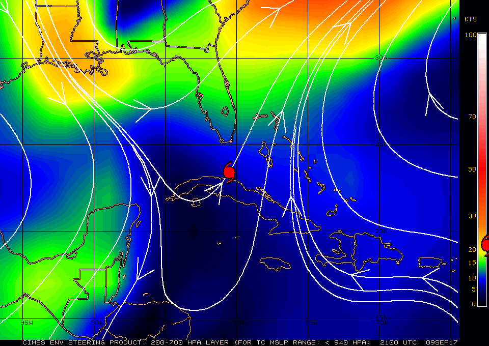 |
| Fig. 6 Estimated steering currents for Hurricane Irma on the afternoon of September 9th. White lines with arrows indicate direction of steering, image indicates forward speed. Note Irma’s location over the north coast of Cuba, between the Bermuda ridge to the east and a ridge over the western Gulf of Mexico. The mid-upper trough between these ridges steered Irma to the northwest, then north. Image courtesy of UW CIMSS. |
Resilient Irma made a final attempt to re-intensify while crossing the open waters of the Florida Straits. The storm quickly reached category-4 intensity with 130 MPH winds early in the morning of September 10th, while approaching the vulnerable Florida Keys. Fortunately for much of the rest of Florida, Irma finally began to encounter unfavorable atmospheric conditions for hurricanes. The shear, which had been so light for so long, was rapidly increasing in Irma’s path as a trough of low pressure developed in the Gulf of Mexico (Fig. 7). Additionally, dry air associated with this trough was beginning to disrupt Irma’s inner core.
 |
| Fig. 7 Upper-level flow (white lines with arrows), based on satellite estimates of 200 mb winds (40,000 ft AGL). Image is vertical wind shear in knots, with yellows and reds being unfavorable for tropical cyclones (i.e. strong wind shear). Note Irma’s location over southwest Florida on the afternoon of September 10th. Image courtesy of UW CIMSS. |
The major hurricane made landfall near Marco Island in southwest Florida around 3 pm EDT on September 10th, as a category-3 storm with 115 MPH. Naples, Florida reported a peak wind gust of 142 MPH. Irma moved quickly northward, just inland from the west coast of Florida on September 10th and 11th. When Irma first developed in the far eastern Atlantic, despite its strength, its wind field was quite small. As the storm approached Florida, however, its wind field expanded dramatically. As Irma hit Florida, tropical storm force winds extended outward up to 400 miles from the center, and hurricane force winds extended up to 80 miles. Hurricane force wind gusts (i.e. 74 MPH or more) were reported along much of the east coast of Florida, from Jacksonville to Miami. In addition to the long periods of heavy rain and strong winds, storm surge flooding also occurred well away from the storm center, including the Jacksonville area, where strong and persistent onshore winds had been occurring for days before Irma’s center made its closest approach.
By the time the minimal hurricane reached northwest Florida (on the morning of September 11th), the wind gusts across south Georgia and northwest Florida were generally in the 45 to 60 MPH range (Fig. 8). Conditions improved rapidly once the storm center passed by as strong, dry southwest winds aloft made the system asymmetric, with nearly all of the rain and most of the strongest winds being along and north of the poorly-defined center. Irma weakened to a tropical storm in south Georgia in the afternoon, and further into a tropical depression while moving north across central Georgia in the evening.
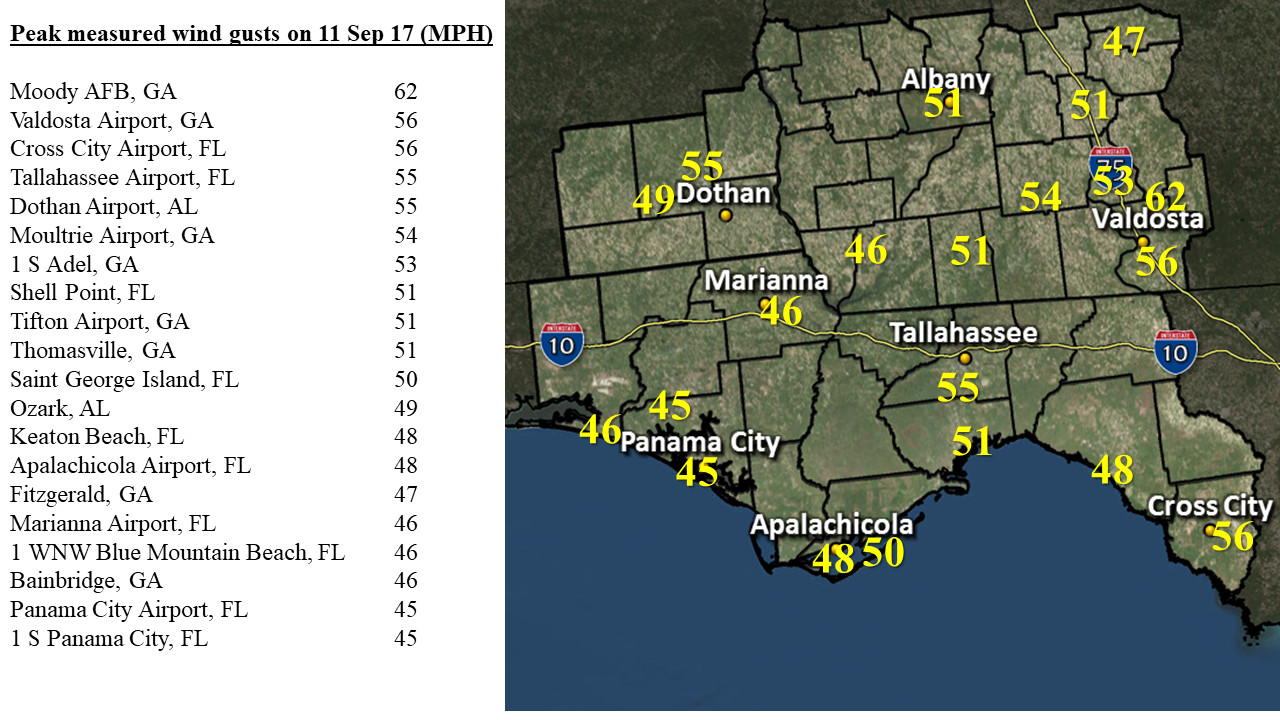 |
| Fig. 8 Measured local wind gusts associated with Irma. |
The residents of northwest Florida and south Georgia were fortunate compared to much of the rest of Florida. Had Irma taken its turn to the north slightly later, the center of Irma would have remained offshore the Florida west coast. Irma would still have weakened due to the increasingly unfavorable atmospheric conditions, but this weakening trend may have been slower with the center still over the warm waters of the eastern Gulf of Mexico. A slightly more western track could also have allowed for a brief period of onshore winds in Apalachee Bay, increasing the risk for storm surge. Irma’s track to the east of Tallahassee resulted in a prolonged period of strong offshore winds, which actually kept the tides in Apalachee Bay lower than normal for much of the event (Fig. 9).
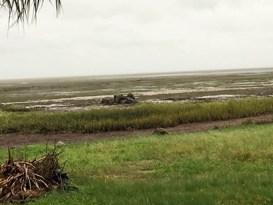 |
| Fig. 9 Picture taken by Taylor County Emergency Manager showing the coast of Taylor County on the morning of September 11th. During this time the strong offshore winds actually caused below-normal tides along the coast of Apalachee Bay. In this picture, the Gulf of Mexico waters, which normally covers much of the area shown, appear far away. The tide did come up later in the day as the winds shifted from north to west after the passage of Irma’s center, but no significant flooding was reported. |
 |
| Fig. 10 Satellite IR image showing Hurricane Irma, one of the strongest hurricanes ever in the Atlantic basin, near peak intensity on the afternoon of September 6th, just north of Puerto Rico. Maximum sustained winds are 185 MPH, and central pressure is 914 mb on the 5 pm EDT NHC advisory. Image courtesy of UW CIMSS. |
Coldest clouds are shown in white, warmest surface temperatures in blue. Note the perfectly circular cloud pattern, the warm spot (the eye of the hurricane, where the satellite sensor can “see” to the warm ocean surface) surrounded by the symmetrical ring of extremely cold (tall) thunderstorm cloud tops, and the fanning out of thin, high-level clouds indicative of air being evacuated from the core of the storm. This is a textbook image of how an intense hurricane appears in a low shear, moist atmosphere with very warm water below.
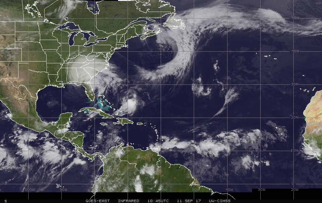 |
| Fig. 11 Satellite IR image showing the center of Hurricane Irma, as a minimal hurricane, along the northwest Florida coast just inland from Cedar Key early in the morning of September 11th. Maximum sustained winds are 75 MPH, and central pressure is 965 mb on the 5 am EDT NHC advisory. Image courtesy of UW CIMSS. |
Note how the coldest cloud tops (white) are north and east of the storm center. This is due to strong wind shear (from strong southwest winds in the upper atmosphere), and dry air in the mid and upper levels of the atmosphere wrapping into the storm, and the fact that the hurricane’s center had been over land for at least 12 hours.


 Follow us on YouTube