| A Review of Local Weather in 2005 |
The 2004 hurricane season will long be remembered by residents of Florida due to the number of tropical storms and hurricanes that affected the state in the 6-week period from mid August through late September. However, the 2005 season actually saw a greater number of tropical cyclones impact the state. The 2005 season set many all-time records for the Atlantic Basin as a whole. Five hurricanes and three tropical storms menaced the state of Florida this year. Three of the hurricanes made landfall in Florida (Dennis, Katrina, and Wilma), while a fourth (Rita) passed just 50 miles south of the Keys. Both Dennis and Wilma made landfall as major hurricanes, Dennis near Navarre Beach on the afternoon of July 10, and Wilma in Southwest Florida around Cape Romano, on 24 October. Cindy made landfall in Louisiana, but brought tropical storm force gusts to the western Panhandle on July 6. Two tropical storms made landfall in the Sunshine State (Arlene and Tammy), while a third (Ophelia) remained off the east coast on 7-8 Sept., briefly reaching hurricane strength. Wind and rainfall impacts to the local forecast area this season were far less than what the area experienced in 2004. However, Hurricane Dennis brought devastating storm surge flooding to the Big Bend and Panhandle coastline on July 10. The local area was also impacted to a much lesser degree by Hurricanes Cindy, Katrina and Wilma, and Tropical Storm Arlene. Details on local impacts from this season's tropical cyclones can be found further down the page.
As can be seen in Figure 1 (below), temperatures started out above normal at the beginning of the year, with a transition to cooler than normal temperatures for the late winter and most of the spring, particularly April and May. The summer months were near normal for the most part. However, a lengthy period of above normal temperatures commenced in mid August, and continued for the next three months. Temperatures in September and most of October were well above normal. The holiday season saw a return to below normal temperatures, but a warm spell ended the year much the same way it began. For the third summer in a row, and the fourth time in five seasons, temperatures failed to reach the century mark in Tallahassee. Figure 2 (below) shows that Tallahassee ran a precipitation deficit through the first three months of the year, due mainly to a very dry January. Frequent heavy spring rains in March and early April nearly erased the initial deficit. The remainder of the spring saw near normal rainfall. Summer rains were plentiful in early June and through most of July and August. Tallahassee experienced its third wettest August and summer season (June-August) on record. The spigot was abruptly turned off on September 1, with significant rain falling only once during the next two and a half months. Frequent rains returned around Thanksgiving, commensurate with the shift to cooler temperatures, and continued through most of December. The annual rainfall total was 68.29 inches in The Capital City, which is 5.08 inches above normal. Following are some of the weather highlights that occurred in the NWS Tallahassee County Warning & Forecast Area in 2005.
Very Warm & Dry Start to the Year
An unusual stretch of warm and dry weather that began just before the new year continued through the first two weeks of January. Temperatures reached the 70-degree mark each day from December 31 through January 13. Temperatures did not dip below the mid 40s at night until the 16th. No daily record maximum temperature records were set in Tallahassee during this period. However, Apalachicola broke a record high on the 8th and tied the record for the 9th. Panama City tied a record high on the 3rd and broke a record on the 12th. This period was also quite dry, with only 0.01" of rainfall at TLH from December 27th through January 12th. A cold front brought showers and thunderstorms and a little over an inch of rain to Tallahassee on the 13-14th, and a transition to a period where temperatures were cooler than normal for much of the rest of the month. Morning low temperatures finally dipped below freezing in Tallahassee on the 18th. Freezing temperatures were observed on only 6 of the 31 days in January, which is 5 below normal. Three of these were hard freezes. The coldest temperature of the year occurred on January 24th when the mercury dipped to 19 degrees in Tallahassee. January 2005 was 2.9 degrees warmer than normal, despite the cooler temperatures later in the month. The rainfall total of 1.46 inches was nearly 4 inches below normal. The coldest afternoon of the 2004-2005 winter season occurred on December 24th, when the mercury never rose above 39 degrees. February was about a degree warmer than normal with four freezes during the month, and no temperature records were set.
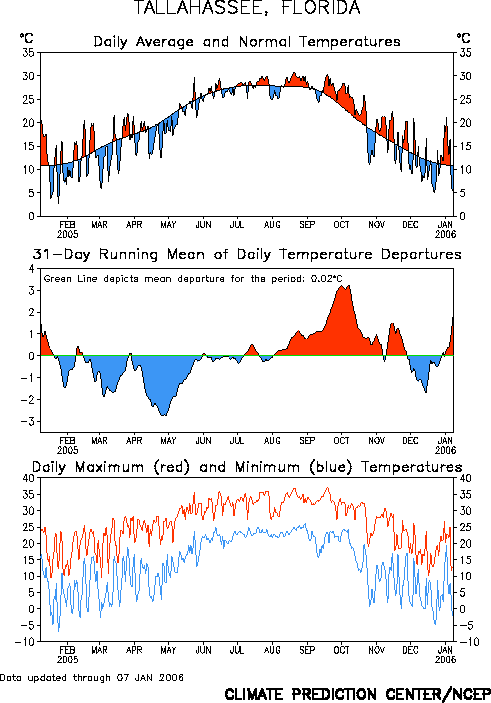
Figure 1. Temperatures in Tallahassee during the year 2005.
Cool and Wet Spring
The spring months of March-May were all cooler than normal, with wetter than normal conditions in March and April. March, typically a stormy month, saw 7.10 inches of rainfall in Tallahassee, 0.63 inches above normal, along with several severe weather outbreaks. In Apalachicola, 7.72 inches of rain fell, which is 2.77 inches above normal. In Panama City, a whopping 9.79 inches fell, just over 3.5 inches above normal. Albany, GA, had 9.62 inches of rain in March, nearly 4 inches above normal. Valdosta, GA, also received about nine inches of rain for the month. April, typically the driest month of spring, saw four days with greater than an inch of rainfall in Tallahassee, and a monthly total of 6.67 inches, nearly twice normal. Apalachicola was even wetter with three days recording over two inches of rain and a monthly total of 9.33 inches, over three times normal and the 7th wettest on record. Three inches of rain fell on April 1st alone. In Panama City, 9.49 inches of rain fell during April, over 250% of normal. Additional monthly rainfall totals include 9.09 inches at Dothan, 7.06 inches at Albany, and 6.12 inches at Valdosta. May was drier than normal across the region, with just one inch of rain falling in Albany and 1.07 inches in Panama City.
There were only seven days in April with above normal temperatures in Tallahassee. The monthly average temperature was four degrees cooler than normal, with the maximum temperature of the month just 83 degrees. At Apalachicola, new daily record minimum temperatures were set on the 17th and 25th. The city also tied record lows on May 7th and 8th. Panama City broke their daily record high temperature on May 11th. The mercury reached the 90-degree mark for the first time of the season in Tallahassee on May 20th.
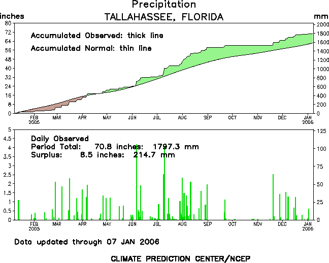
Figure 2. Rainfall in Tallahassee during the year 2005.
Very Wet Summer without Extreme Temperatures
For the third summer in a row, the mercury never reached the century mark across most the forecast area during meteorological summer (June-August). The maximum temperature in Tallahassee during this period was 98 degrees, which occurred on August 20th and 21st. The city tied is all-time warmest minimum daily temperature when the mercury never fell below 80 degrees on August 30th. Albany, GA, also peaked at 98 degrees on July 27th and 28th, and again on August 21st. Apalachicola's summer maximum of 95 degrees was recorded on July 23rd. The summer maximum at Dothan, AL, was also 95 degrees on July 23rd, as well as August 21st and 22nd. Valdosta, GA, managed to reach 100 degrees on August 22nd. This was the hottest temperature of the summer recorded anywhere in the local forecast area. While temperatures were near normal across most areas, Panama City saw temperatures well above normal during the summer, likely due to a continuation of the dry conditions that commenced there in May and continued through the summer (see below). Panama City reached its peak summer temperature on July 24th when the mercury reached 98 degrees. Interestingly, this is the exact date and temperature for Panama City's summer maximum in 2004. The city tied a record high temperature on June 15th at 94 degrees. While no other daily records were established, June, July and August were all much warmer than average, with departures of 3.7, 4.0, and 3.5 degrees above normal, respectively. Only six days over the three month period saw below normal temperatures, with none occurring in June.
Temperatures were once again tempered by abundant summer rains. Tallahassee experienced its 3rd wettest summer on record, as well as the 3rd wettest August. Over the three month period, 34.49 inches of rain fell in the Capital City, with 14.33 inches coming in August alone, more than twice normal. Daily rainfall exceeded one inch on twelve days during the season. The biggest rain event of the year was associated with Hurricane Dennis, when 6.64 inches of rain fell in Tallahassee on July 9-10th. Albany, GA, and Dothan, AL, also saw rainfall totals well in excess of normal. Conditions were much drier during the summer for coastal communities, with Apalachicola receiving near normal rainfall. In Panama City, all three months were drier than normal, with just 16.56 inches of rain falling during the season, 5.71 inches below normal.
Very Warm & Dry Autumn
The area began transitioning to consistently above normal temperatures and below normal rainfall beginning in late August, with the warm weather continuing through early November. Annual maximum temperatures were actually set in the third week of September across many areas. Tallahassee tied their summer maximum temperature on Sept. 18th, when the mercury hit 98 degrees, breaking the daily record. However, the annual maximum occurred the next day, with a high temperature of 99 degrees on Sept. 19th, the hottest temperature since July 2002. The average daily maximum temperature for the month was 92 degrees, which is normal for July. Temperatures reached the mid to upper 90s on eight consecutive days from the 14th through the 21st. Only two of the first 25 days of the month failed to reach 90. This was the 5th hottest September on record in Tallahassee. The month was also quite dry with only a trace of rain falling during the first 20 days of the month. The monthly total of 1.60 inches was less than a third of normal. Apalachicola did not set any temperature records, but also went without measurable rain for the first 20 days. Their monthly total of 1.31 inches was just 18% of normal. Dothan tied their summer maximum temperature on the 18-19th, with 95 degrees both days, and monthly rainfall totaled just over one inch. Albany failed to set any daily temperature records, but did see mid to upper 90s on nine consecutive days from the 13th-22nd, tying their summer maximum of 98 degrees on the 16th, 18th, and 19th. Temperatures for the month averaged over four degrees above normal. Albany went without measurable rain for 21 days, from the 2nd through the 22nd. The monthly total of 1.24 inches was less than a third of normal.
Panama City shattered temperature records during September. Daily maximum temperature records were tied or broken on six consecutive days from the 16th to the 21st. The 100-degree reading on the 19th, broke the all-time maximum temperature record for the month of 98 degrees, set previously on Sept. 2nd, 1989. The average monthly temperature of 83.0 degrees was the hottest on record as well, breaking the old record of 81.9 degrees set three years earlier. Finally, the average daily maximum temperature for the month of 92.3 degrees broke the previous record of 91.5 degrees set in 1954. The city was completely rain-free for the frist 18 days of the month and recorded just 0.99 inches thereafter, just 16% of the normal monthly total.
October continued the hot and dry spell. While September temperatures were reminiscent of July, those observed during the first three weeks of October were more typical of September. In Tallahassee, temperatures reached the 90-degree mark eight times, including a four day stretch from the 18th through the 21st that saw daily maximum temperature records either tied or broken. The high of 91 on the 19th marks the latest date in the season that the mercury has exceeded 90 degrees. Temperatures turned sharply colder for the last week of the month with temperatures failing to reach 70 on the 24th & 25th and morning lows in the 30s on four of the last six days of the month. The low of 33 degrees on the 26th broke the record for the date of 35 degrees set in 1968. Despite the late month cool down, temperature still averaged 2.3 degrees above normal. Only 0.08 inches of rain fell during the month, just 2.5% of normal and tying for the 8th driest on record. Absolutely no rain fell over the final 24 days of the month. In Panama City, no temperature records were set. However, temperatures averaged over 4 degrees above normal for the month, and rainfall was just 9% of normal at 0.32 inches.
Unseasonably hot and dry weather continued through the first half of November. In Tallahassee, the mercury reached 87 degrees on the 8th & 9th, breaking and tying records respectively. The high of 85 on the 14th also broke a daily record. Temperatures reached 80 or better on 15 of the first 16 days of the month. Temperatures turned colder once again during the 2nd half of the month with Tallahassee recording the first freezing temperature of the season the day before Thanksgiving, when the mercury dipped to 32 degrees on the 23rd. Despite this chill, temperatures averaged nearly three degrees above normal for the month. Only 0.08 inches of rain fell over the first 19 days of the month, with that total also representing total rainfall over the 43-day period from October 5th through November 19th. The first significant rainfall in two months fell on the 20th when the airport picked up 2.46 inches of rain. An additional rainfall event later in the month brought the monthly total to 4.35 inches, which was actually almost a half an inch above normal. Rainfall for the entire fall season (Sept.-Nov.) totaled just 6.03 inches, or half of normal. In Panama City, daily record high temperatures were broken on the 8th and tied on the 14th. Temperatures for the month average five degrees above normal. Albany, GA, tied their record high temperature for November 15th at 85 degrees, and monthly temperatures averaged 3.5 degrees above normal.
Tropical Storm Arlene
Tropical Storm Arlene came ashore just west of Pensacola, FL, on the afternoon of Friday, June 11. Maximum sustained winds reached 40 mph at Buoy 42039 located 80 miles south of Panama City, FL, with a peak gust of 52 mph late Thursday evening. The lowest sea-level pressure recorded in the forecast area was 997.7 mb at Buoy 42039. Storm total rainfall ranged from two to four inches throughout much of the Florida Panhandle and Big Bend. Storm surge heights associated with Arlene ranged from five feet along the Walton County coast to three to four feet along the Wakulla County coast. Moderate beach erosion occurred from Walton to Franklin County. Storm surges and moderate to heavy wave action, which accounted for 80 percent of the damage, marred walkways in Bay County, washed out much of Alligator Point Road in Franklin County, and pushed seaweed ashore in Wakulla County. Downed trees on power lines caused an estimated 500 customers to lose power in Walton, Washington, and Bay counties. Additional information on Tropical Storm Arlene can be found here.
Hurricane Cindy
Cindy came ashore just southwest of Grand Isle, LA, early on Monday, July 6. Cindy briefly reached minimal hurricane strength before landfall. Local impacts from Cindy were minor. Only one tropical storm force wind gust was observed in the area at Destin, FL. Dothan, AL picked up a little over an inch and a half of rain. No storm surge was reported. However, there was some minor beach erosion. Additional information on Hurricane Cindy can be found here.
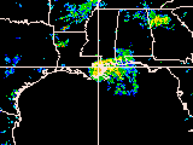
Figure 3. Doppler radar mosaic image of Hurricane Cindy just before the storm made landfall in Southeast Louisiana, during the early morning hours of July 6, 2005. Click on the image for a long radar loop of the storm.
Hurricane Dennis
Just five days after Cindy made landfall, Dennis, a Category 3 hurricane, moved inland between Gulf Breeze and Navarre, FL, early Sunday afternoon, July 10. While hurricane-force winds associated with Dennis covered only a small area near the eye, the hurricane had a large cyclonic envelope with tropical storm-force winds extending well to the east of the center over southern Florida and the Florida Panhandle. Tropical storm conditions also occurred over the Florida Big Bend region. The highest wind gust reported in the local forecast area was 73 mph at Panama City Beach. This is just shy of hurricane force. Sustained winds there peaked at 59 mph. Sustained tropical storm force winds were also observed at Apalachicola, where winds peaked at 47 mph and gusts reached 64 mph. Tropical storm force gusts were also observed at Panama City (55 mph), Dothan, AL (51 mph), Tallahassee (51 mph), Albany, GA (43 mph), and Valdosta, GA (39 mph). The worst property damage occurred along the coast from Walton to Wakulla County, where more than a 1,000 homes and businesses were affected. Also, there were numerous reports of downed trees and power lines across the Florida Panhandle and Big Bend, leaving about 75,000 customers without power. The Coffee County AL EMA reported trees down on eight county roads, several downed trees on power lines causing scattered power outages, and debris on roads. Wind gusts blew a carport into a wall of a house on County Road 656. About 1,000 customers were without power. In Dale County, the EMA reported James Street in Ozark washed out and a tree down on a house. There were many reports of trees and power lines down, with nearly 3,000 customers without power. In Geneva and Henry counties, EMA officials reported minor tree and power line damage, with about 1,500 customers without power. The Houston County EMA reported numerous downed trees and power lines, with nearly 6,500 customers without power. Several streets in and around Dothan were littered with fallen debris. Some homes reported minor damage from fallen trees. In Southwest and South Central Georgia, dozens of homes and businesses in Putney lost power. About 5,000 Albany customers were without power. At Mitchell County Middle School, strong winds caused roof damage. 6,000 customers were without power in Decatur, Grady, and Thomas counties. Disaster assistance was granted to Colquitt and Worth counties.
Heavy rainfall commenced July 10, and persisted into the early morning hours of July 11. A nearly stationary feeder band from the eastern Florida Panhandle into southwest Georgia produced four to eight inches of rain, with isolated amounts up to a foot. Rainfall totals ranged from 3 to 4 inches in the eastern Florida Panhandle, with 6 to 10 inches reported in the Florida Big Bend. Tallahassee picked up 6.64 inches of rain, which flooded many county and city roads. Extensive flooding was reported in southern Leon County where several areas were under 3 to 4 feet of water. Some of the worst flooding in the area occurred in Worth County, GA, where 8-11 inches of rain caused flooding that displaced 78 families in Sylvester. A total of 300 homes were evacuated, and 80 damaged by flood waters in the county. In Colquitt County, flash flooding along the Okapilco Creek in Moultrie damaged many homes, washed out roads, and forced the evacuation of 100 homes. Several Decatur County roads were washed out. In Terrell County, many roads were flooded. Fishpond Drain in Seminole County flashed with several homes surrounded by rising flood water. A pond dam burst and caused a torrent of water to overrun a road in Tift County. Rainfall amounts ranged from two to four inches across extreme southeast Alabama. A large portion of eastern Thomas County observed between 6 and 11 inches of rain. A few Boston homes were evacuated and many county roads were washed out. Heavy rains in the upper Flint River basin generated high flows which reached as far south as Bainbridge, GA. Minor flooding occurred along the Flint and Withlacoochee River basins with a few homes affected by high water.
The biggest story with Dennis was the incredible storm surge that occurred well east of the landfall point. Maximum coastal storm surge heights ranged from 4 to 8 feet in Walton, Bay, Gulf, Taylor and Dixie counties, and 8 to 12 feet in Franklin, Wakulla and Jefferson counties. The storm surge was 6-9 ft above normal tide levels in the Apalachee Bay, which inundated parts of the town of St. Marks and nearby areas with waist deep water. This surge was higher than currently known wind reports would support for that area, and roughly 3.5 ft higher that the surge forecast from the Sea, Lake, and Overland Surge from Hurricanes (SLOSH) model. This surge was likely triggered by an oceanic trapped shelf wave that propagated northward along the Florida west coast. Modeling results from the Center for Ocean-Atmospheric Prediction Studies at Florida State University suggest that although Dennis was roughly 150 nautical miles west of the area, this remotely generated sea-level rise added 3-4 ft to the surge in and around Apalachee Bay. Moderate to severe beach erosion was observed along the beaches of Walton, Bay, Gulf, Franklin and Wakulla counties. Across coastal Walton County, all public dunes and walkovers were damaged. At St George Island, five miles of road and numerous structures were damaged or destroyed by Dennis' storm surge. Dennis' deluge caused several rivers and creeks in the Florida Panhandle and Big Bend to exceed their flood stages, including the Ocklockonee, Aucilla, and St Marks rivers, and Spring Creek. An interesting aspect to the flooding is the remarkable surge of up to 8 feet that propagated up the rivers. This surge was evident from the mouth of the Suwannee River to as far west as the Choctawhatchee River. Bay, Dixie, Franklin, Gulf, Taylor, Wakulla and Walton counties were declared federal disaster areas. Overall, the surge destroyed dozens of home and businesses along the Big Bend and Panhandle coast,with several hundred others damaged. An 18-year-old male drown in heavy surf off Panama City Beach, while 13-year-old girl was dragged 600 yards out to sea by a rip current and also drowned. Additional information on Hurricane Dennis can be found here.
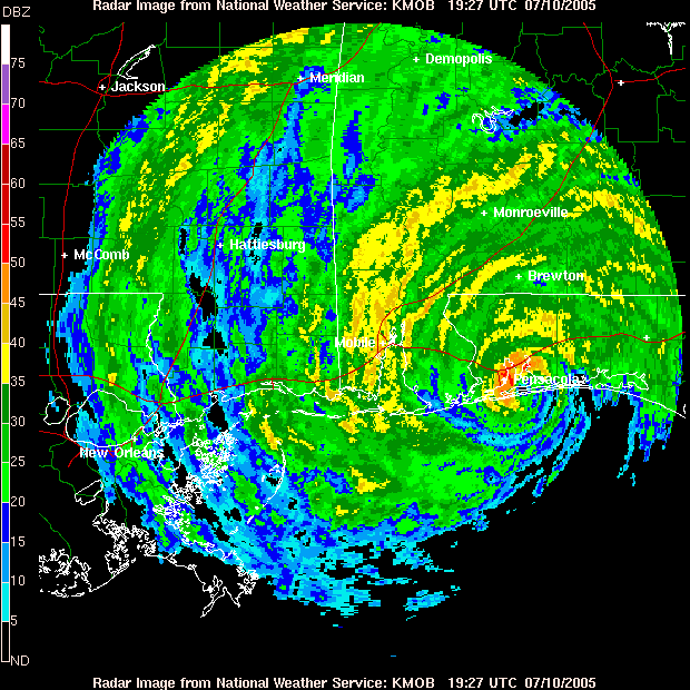
Figure 4. Doppler radar image of Hurricane Dennis as it made landfall between Navarre and Gulf Breeze, FL, on the afternoon of July 10, 2005. Click on the image for a larger view.
Katrina
Catastrophic Hurricane Katrina came ashore early Monday morning, August 29, just east of Grand Isle in southeast Louisiana with 125-mph winds. Locally, the impacts from Katrina were rather minor. The maximum sustained and peak winds in the local area of 37 and 46 knots, respectively, were recorded at the Buoy 42039, 80 miles south of Panama City, FL. The lowest sea level pressure recorded in the area was 1000.2 mb at Buoy 42039. Rainfall totals for the 48-hour period ranged from one to three inches. Maximum storm surge heights were around five feet from Wakulla County westward and two feet across Taylor and Dixie counties. Severe beach erosion occurred across coastal Walton County as well as coastal portions of Bay and Gulf counties. Moderate beach erosion was observed from St George Island to Bald Point of Franklin County. Law enforcement officials reported some county roads flooded across coastal Walton County. Mandatory evacuations were ordered for coastal areas of Walton, Gulf, Franklin and Wakulla counties. Additional information on Hurricane Katrina can be found here.

Figure 5. Doppler radar image of Hurricane Katrina at the time of its closest approach to New Orleans, LA, on the morning of August 29, 2005. Click on the image for an animated loop.
Wilma
While Wilma ravaged much of South Florida on the morning of October 24, only peripheral affects were felt this far north. Cross City in Dixie County recorded a peak wind gust of 38 mph, just shy of tropical storm force. The city received about an inch and a half of rain, and no flooding was reported. Some minor beach erosion occurred at Cape San Blas, Alligator Point, and on St. George and Dog Islands, all of which had sustained more significant damage from Arlene, Dennis and the 2004 storms. All of this activity over the past two seasons was too much for the 153-year-old lighthouse on Little St. George Island, which toppled on October 20. Additional information on Hurricane Wilma can be found here.
Cold and Wet Late Fall to Early Winter - Sharp Warm-up at Year's End
The cool and wet pattern of late November continued through the first three weeks of December. Temperatures in Tallahassee averaged below normal on all but six of the first 27 days in the month. While it was cool, their were few freezes until just before Christmas. Tallahassee briefly dipped to 32 on the morning's of the 13th, 14th and 21st. However, the first widespread freeze of the season occurred on the 22nd, when the mercury dropped to 25 degrees at Tallahassee. The next morning dropped to 23 degrees, the coldest temperature of the month. Valdosta also reached 25 degrees that morning. Albany dropped to 22 degrees on the 22nd, the coldest temperature in the area during December. Freezes occurred all the way to the coast on the 22nd and 23rd, with lows at Apalachicola dropping to 29 and 28 degrees respectively. Panama City also reached 28 degrees on the 23rd. Overall, there were seven days where temperatures dropped to 32 or lower in Tallahassee, which was three fewer than normal. There was a nice warm up at year's end with the mercury climbing all the way to 80 degrees on New Year's Eve in the Capital City. This tied the record for the date, set previously in 1971. Apalachicola reached 77 degrees, which broke their record by a degree. Overall, temperatures averaged about two degrees below normal for the month in Tallahassee, where several rain events during the early and middle part of the month resulted in a monthly total of 5.36 inches, 1.26 inches above normal.
Severe Weather
Typically, this part of the country sees a peak in severe weather activity during the spring months with a secondary maximum in November. Through summer, isolated severe storms are possible on almost any day, although large outbreaks are much less common. Occasionally severe weather occurs in the winter months, and some of these can be major outbreaks. 2005 generally followed these trends, although the secondary autumn peak occurred in December, rather than November. The peak spring severe weather season was active, particularly in March. Monthly summaries of severe weather occurrences in 2005 can be obtained by clicking the links below.
Previous Years
Reviews of local weather in 2004, 2003, 2002, 2001 and 2000 are also available.
National Weather in 2005
An article summarizing last year's weather across the global has been published by NOAA. A more detailed summary has been posted by NCDC. Also included in this site is a collection of significant weather events that occurred nationally in 2005.


 Follow us on YouTube