| Severe Weather of April 14-15, 2007 |
Beginning Saturday evening, April 14, and continuing into the early morning hours of Sunday, April 15, 2007, the NWS Weather Forecast Office in Tallahassee issued 34 warnings. These included 8 tornado, 21 severe thunderstorm, and 5 special marine warnings. Three tornadoes were confirmed by NWS survey crews, one each in Dale County, AL, and Lee and Worth Counties in GA. Fortunately, there were no fatalities or injuries during this event. Figure 1 shows the damage paths of the tornadoes, indicated by the charcoal gray ovals. Following the image is a preliminary assessment of the three tornadic stroms, and other severe weather that occurred during the event.
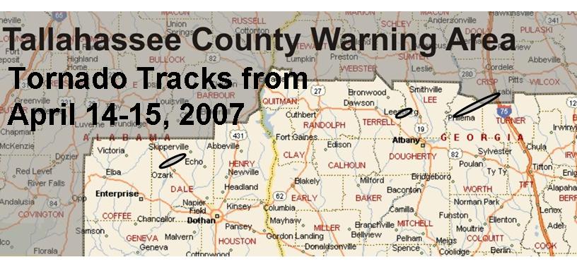
Figure 1. Damage paths of the three tornadoes of April 14-15, 2007, indicated by the charcoal gray ovals. Click on the image for a larger view.
The first tornado of the evening touched down in Dale County, AL, at 0005 UTC 15 April (7:05 PM CST 14 April). An NWS Storm Survey Team determined that a tornado rated EF-1 on the new enhanced Fujita Scale touched down approximately one mile west of the Marley Mill community and stayed on the ground for seven minutes, lifting at around 0012 UTC 15 April (7:12 PM CST 14 April) just east of Beamon. The tornado skipped along the ground along a 4.5-mile damage track, with a maximum width of 150 yd.
Figures 2 and 3 show the base reflectivity and storm-relative velocity images at the time the twister first touched the ground. In the velocity image, note that this tornado was located in the head of a bookend vortex.
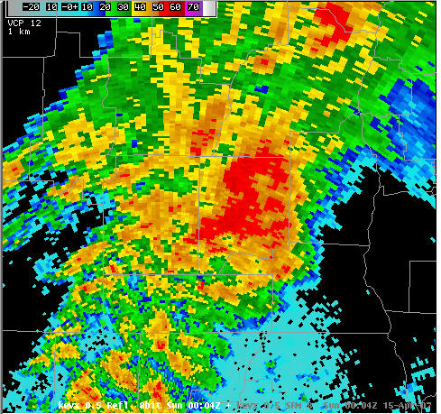
Figure 2. The base reflectivity image from the Eglin AFB, FL, Doppler Radar (KEVX) for 0004 UTC 15 April 2007 (7:04 PM CST April 14).

Figure 3. The base storm-relative velocity image from the Ft. Rucker, AL, Doppler Radar (KEOX) for 0005 UTC 15 April 2007 (7:05 PM CST April 14).
Another probable tornado produced EF-1 type damage near the Lee-Terrell County line, mostly near Highway 32, at approximately 0230 UTC 15 April (10:30 PM EST 14 April). Eight to ten structures were damaged with two destroyed. Figure 4 shows the worst of the damage found during an NWS survey of the area.
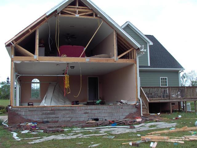
Figure 4. Damage sustained by a home in Lee County, GA, from a tornado that struck on Saturday evening, April 14, 2007.
The final confirmed tornado of the night touched down in Worth County, GA, four miles southeast of Warwick at 0723 UTC 15 April (3:23 AM EST), crossing into Crisp Co. before lifting at 0739 UTC 15 April (3:39 AM EST). The tornado stayed on the ground for 16 minutes, with a total path length of 14 miles across the two counties, and a maximum width of 200 yd. Figures 5 and 6 show the base reflectivity and storm-relative velocity images from the Tallahassee, FL, (KTLH) Doppler radar at the time the twister first touched the ground. Figure 7 shows some damage from the tornado.

Figure 5. The base reflectivity image from the Tallahassee, FL, Doppler Radar (KTLH) for 0723 UTC 15 April 2007 (3:23 AM EST).

Figure 6. The base storm-relative velocity image from the Tallahassee, FL, Doppler Radar (KTLH) for 0723 UTC 15 April 2007 (3:23 AM EST).

Figure 7. Damage sustained by a home in Worth County, GA, from a tornado that struck early Sunday morning, April 15, 2007.
The SPC reports archive summarizes all of the severe weather that occurred.


 Follow us on YouTube