| Severe Weather of February 17-18, 2008 |
Beginning Saturday afternoon, February 17, and continuing into the early morning hours of Monday, February 18, 2008, the NWS Forecast Office in Tallahassee issued 34 warnings. These included 9 tornado, 17 severe thunderstorm, and 8 special marine warnings. So far, two tornadic thunderstorms were confirmed by NWS survey crews. One tracked across northwest Coffee County, AL. A second affected northern Gadsden County, FL , and Decatur and Grady Counties in GA. Fortunately, there were no fatalities associated with this severe weather episode. However, two people were injured in the Tallahassee County Warning Area: one on Interstate 10 in Gadsden County, and another in a trailer home in Grady County. There were 46 other injuries reported across Central AL and northern GA.
The first confirmed tornado touched down in Crenshaw County in AL, and crossed far northwestern Coffee County before moving into Pike County, AL. Damage in this area was rated EF-1 by a NWS survery crew from NWS Birmingham, AL. In Coffee County. roofs were torn off a couple of barns with the roof of one single family home partially removed. The damage path of the tornado was estimated to be 100 yards with maximum winds around 95 mph in Pike County. Figure 1 shows the tornadic storm as it cross northwest Coffee County Sunday afternoon. note the classic "hook echo" in the reflectivity image.
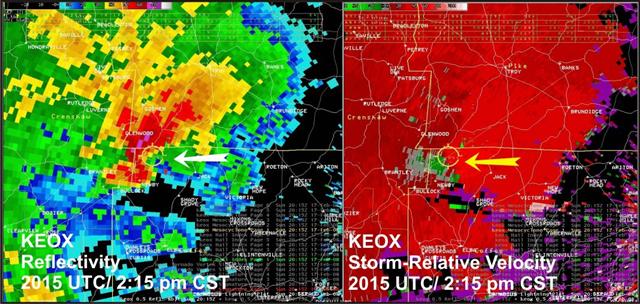
Figure 1. Reflectivity and base velocity images from the Ft. Rucker WSR-88D radar at 2015 UTC 17 February (2:15 pm CST). Click on the image for a larger view.
Figure 2 shows the track of the second tornadic thunderstorm, indicated by the charcoal gray oval, with damage survey locations indicated by orange circles. Following the image is a preliminary assessment of the tornadic storms, and other severe weather that occurred during the event.
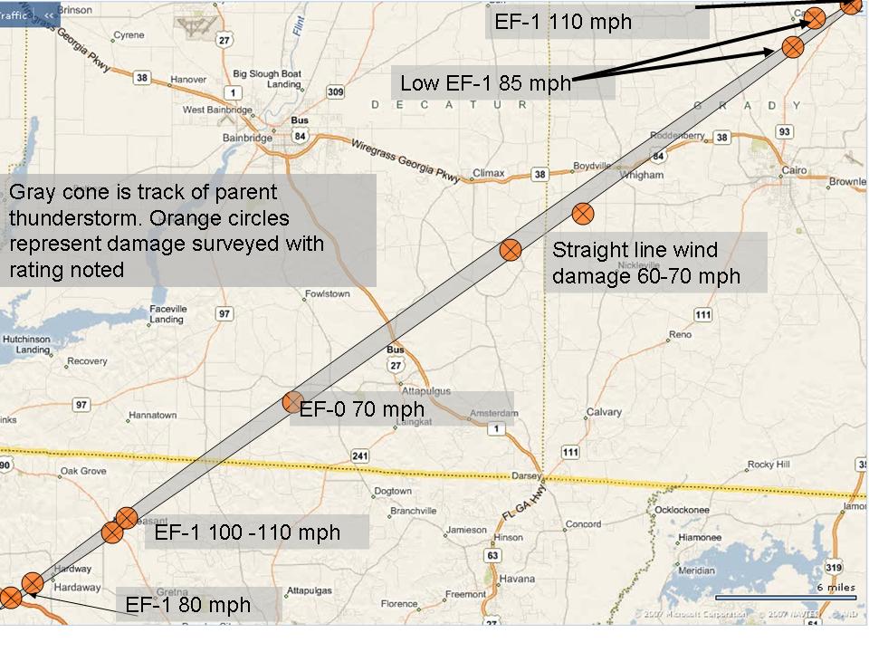
Figure 2. Track of the tornadic thunderstorm of February 18, 2008, indicated by the charcoal gray oval. Damage survey locations are indicated by orange circles. Click on the image for a larger view.
The Gadsden-Decatur-Grady tornadic thunderstorm first touched down near mile marker 168 on Interstate 10 in Gadsden County, FL. The tornado tossed an 18-wheeler off the interstate, injuring the driver. A multi-car accident also occurred. Many trees were felled in the area with debris on both the east- and west-bound lanes. The tornado then moved northeast to near Hardaway where it snapped or uprooted several trees and damaged a couple of mobile homes. The tornado was rated at EF-0 intensity in these areas. The most significant damage in Gadsden County occurred in Mt. Pleasant, where EF-1 damage occurred in an area with estimated 110 mph winds. Figure 3 shows the storm as it passed through the Mt. Pleasant area. Note the tight rotation indicated in the storm-relative velocity data. The maximum width of the damage path was 150 yards. Several homes were significantly damaged with several large trees uprooted. The storm weakened a bit as it crossed the state line into southeastern Decatur County, GA. Tornado damage in this area was rated EF-0 between Attapulgus and Fowlstown. The storm spun up again in neighboring Grady County, where straight-line wind damage was reported southwest of Whigham. Another tornado touched down just east of GA Route 93 near Courtney Lane, several miles north of Cairo in areas south and east of Capel. EF-1 damage was surveyed in this area, with maximum winds estimated at 110 mph and a damage path as wide as 75 yards. Figure 4 shows the storm as it crossed this area. This is an example of a classic book end vortex.

Figure 3. Reflectivity and base velocity images from the Tallahassee WSR-88D radar at 0613 UTC 18 February (1:13 am EST). Click on the image for a larger view.

Figure 4. Reflectivity and base velocity images from the Tallahassee WSR-88D radar at 0656 UTC 18 February (1:56 am EST). Click on the image for a larger view.
Narratives for this event is available for the AL, GA, and FL storms through the Storm Data publication. The SPC archived reports page summarizes all of the severe weather that occurred.


 Follow us on YouTube