SOUTHWEST GEORGIA TORNADO OUTBREAK OF 13-14 FEBRUARY 2000:
AN OVERVIEW
Kenneth J. Gould , T.J. Turnage, Jeffrey D. Fournier, Andrew I. Watson, Robert C. Goree, Ronald L. Block, and Martin C. Trexler
NOAA/National Weather Service
Tallahassee, Florida
1. INTRODUCTION
Beginning Sunday evening, February 13, and continuing into the early morning hours of Monday, February 14th, WFO Tallahassee issued 51 warnings. These included 25 tornado, 23 severe thunderstorm, and 3 special marine warnings. During this time, warnings were issued for four deadly tornadoes, which caused the loss of 18 lives in three southwest Georgia Counties, an event unequaled in south Georgia in nearly 50 years.
This paper will briefly discuss the environment in which these storms developed, as well as the storms themselves. The paper will concentrate on the assessment of the damage these storms inflicted, showing storm and damage tracks. Office performance will also be evaluated. This paper is a companion paper to Turnage et al. (2000), which examines the WSR-88D Mesocyclone Detection and Tornado Detection Algorithm characteristics during the tornado outbreak episode.
A strong moist low-level flow had developed in advance of an approaching cold front. A 100-kt digging jetstreak was observed dropping into the base of a negatively tilted trough aloft. A 50 to 60-kt low-level jet was present, along with a significant vertical shear profile, and ample CAPE. Thus the necessary and sufficient ingredients were in place for severe convective development late on the evening of 13-14 February 2000 in southwest Georgia.
Based upon surveys, interviews, and radar analysis, there appear to have been four "killer" tornadoes that struck southwest Georgia. Preliminary surveys had suggested three tornadoes. A map of the affected area and tornado tracks are shown in Fig. 1. To put the map in prospective, the Florida-Georgia border runs near but just off the bottom of Fig. 1. Interstate-75 is located along the right side of the display.
3.1 Camilla Tornadoes
The first Camilla tornadic storm came ashore from the Gulf of Mexico in extreme southwest Bay County, Florida, at approximately 0130 (all times UTC). The cell rapidly developed a circulation and became Supercell #1. The storm was responsible for extensive straight line wind damage in extreme northern Bay County around 0200 and southwestern Washington County around 0215, before continuing across the northeastern Florida Panhandle into Jackson County. It weakened slightly as it crossed Lake Seminole at 0400, which is the dividing line between Alabama, Florida, and Georgia. Supercell #1 then rapidly regained strength across Seminole County, Georgia. It become tornadic at 0442 near Branchville, Georgia in Mitchell County (Figs. 1 and 2) and remained tornadic (F3) as it passed just south of Camilla before dissipating around 0505. This tornado was responsible for 10 deaths in a mobile home subdivision near Camilla.
The second Camilla tornadic supercell developed in western Seminole County at 0430. Supercell #2 can be observed in Fig. 2 to the southwest of Supercell #1 as the next major area of reflectivity. This supercell ultimately developed a circulation as intense as that of Supercell #1. Ironically, it followed almost the same track as the first Camilla tornado, and may have become tornadic as early as 0529.
Aerial and ground surveys were unable to resolve an individual track associated with this tornado because it overlapped the track of the first. Interviews with survivors and rescue crews seem to corroborate the existence of this tornado. One death is now attributed to this tornado, in the same mobile home subdivision that was struck by the first tornado. An aerial photo (Fig. 3) shows the devastation of the mobile home subdivision. The center of the first Camilla tornado path can be seen from left to right in the center of the picture. The single fatality occurred approximately 250 m south of the first tornado apparently near the lower right of the photo (Fig. 3).
Turnage et al. (2000) discusses the strong evidence of the existence of a second Camilla tornado. The authors know of no reports of "training" tornadoes from separate mesocyclones such as this having occurred before. The 9.3-mile damage swath of the first Camilla tornado is shown in Fig. 4. Fujita scale damage assessments are also shown along the track. The short dashed line south of Camilla represents the only known probable touchdown point of the second Camilla tornado. Radar analyses, however, imply other possible touchdown locations (Turnage et al. (2000).
3.2 Supercell #3
Supercell #3 also developed in southern Seminole County, Georgia, at about 0500. The storm developed on the heels of Supercell #2, exhibiting TVS signatures as it moved rapidly across Decatur County into Grady County. It became tornadic around 0549, approximately 10 miles north of Cairo, and then passed along the northern outskirts of Meigs, Georgia at 0600. By far, the longest tornado track (14.5 miles) belongs to the Grady County tornado (Fig. 5). The tornado, rated F3, killed six people.
The mesocyclone weakened and the tornado dissipated northeast of Meigs. However, it reintensified at 0621 just west of Moultrie, Georgia, in Colquitt County, and became tornadic again around 0639 as it passed near Crosland and Omega, Georgia. The Omega tornado was rated F2, and produced one fatality in Colquitt County near Crosland. Tha damage track (Fig. 6) was approximately 6 miles in length.
During the event, eight personnel handled office functions, five forecasters, two hydrometeorological technicians (HMTs), and one HAM/SKYWARN volunteer operator. Work was divided between a coordinator, who directed office operations, two forecasters who maintained a metwatch over radar and warnings, one forecaster who performed normal public, aviation, and short-term forecasting duties, and two individuals who answered telephones, coordinated with emergency management, and assessed preliminary damage reports. One HMT monitored NOAA Weather Radio (NWR) functions, as the office had just converted over to the new Console Replacement System (CRS) two days prior to the event. As the outbreak developed, the WFO staff performed in an outstanding manner, under very stressful and rapidly-changing conditions. The key to their success included preparation, the ability to anticipate developments, and their skill in using the new technology (e.g., AWIPS, WarnGen, etc.) to quickly and accurately identify the developing supercells which ultimately produced the killer tornadoes. Despite the fact that 51 county and marine warnings were issued in the space of only a few hours, warning lead times for the most dangerous storms were impressive, including 24 minutes for the first Camilla tornado, 39 minutes for the second Camilla tornado, 10 minutes for the Grady County storm, and 20 minutes for the Colquitt County storm. Of the 25 county tornado warnings issued, 16 warnings verified with an average lead time of 32 minutes. Figure 7 summarizes the tornado statistics for the event. It also compares the Tallahassee WFO with national as well as other NWS Southern Region offices.
The Southwest Georgia tornado outbreak struck during the late night and early morning hours. "You couldn't ask for any worse time for a tornado to strike", said Robbie Hopkins, assistant coordinator of Mitchell County's Emergency Management Agency. By far the most critical aspect of warning operations is to make individuals aware that they are in danger, far enough ahead of time so that they can take protective action. In this instance, notification of the potential for severe weather took place over 15 hours in advance with the issuance of a Hazardous Weather Outlook at 6 AM EST on February 13.
Later in the day, the WFO Tallahassee forecasters coordinated with the Storm Prediction Center, the scenario was discussed, and follow-up calls lead to the issuance of a Tornado Watch nearly six hours prior to the deadly tornadoes. Additional WFO staff were called in to deal with the expected outbreak. It is particularly noteworthy that several staff members, alerted to the potential for severe weather during the WFO routine daily coordination briefing on the previous Friday morning, voluntarily called the office and arranged to come in to help prepare for and "work the event". The SKYWARN network was activated, and the Amateur Radio Emergency Services (ARES) coordinator was notified. Arrangements were made for an operator to come to the WFO, activate the office amateur radio station (WX4TAE), and begin collecting real-time reports from amateur radio volunteer spotters. The information he relayed to the WFO team during the event was crucial, and was utilized in statements to emphasize the deadly nature of the storm.
The success in this event is a credit to the personnel at the Tallahassee WFO. The office had "spun-up" to WFO status in November 1999, which included new responsibilities such as public and marine forecasts. The newly-installed Advanced Weather Interactive Processing System (AWIPS) was in commissioning test mode at the time of the outbreak. The new technology was critical to the timeliness of the warnings. The ability to examine 3 to 4 radars simultaneously was extremely important. The warning software package, WarnGen, had just been localized and tailored for the region in December. The NWR CRS system had only been commissioned several days before. Had it not been for the performance and superb teamwork exhibited by the WFO staff, working together to correctly identify and track the developing storms, and then issue exceptionally accurate warnings with long lead times, many more lives would undoubtedly have been lost.
Turnage, T.J., R.R. Lee, and E. D. Mitchell, 2000: WSR-88D mesocyclone characteristics of selected thunderstorms during the southwest Georgia tornado outbreak. Preprints, 20th Conference on Severe Local Storms, Orlando, FL, Amer. Meteor. Soc.
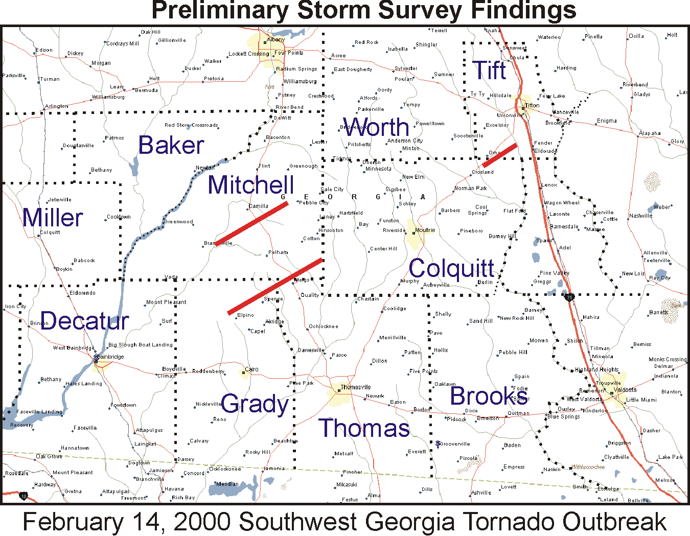
Fig. 1. Tornado tracks associated with the 13-14 February 2000 Southwest Georgia Tornado Outbreak. Dotted lines are county borders.
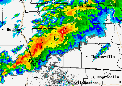
Fig. 2. WSR-88D reflectivity display at 0436 UTC, 14 February 2000. Camilla Supercell #1 is located in western Mitchell County (center of image). Camilla Supercell #2 is developing in Seminole County (two counties to the southwest).
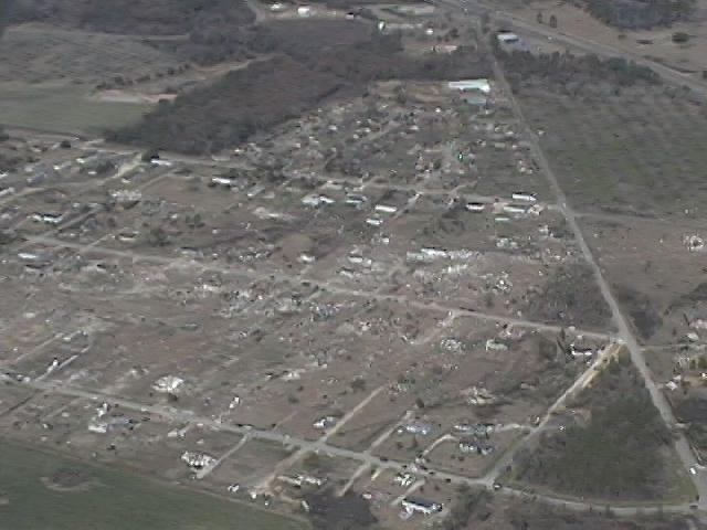
Fig. 3. Aerial photo of Camilla mobile home subdivision.
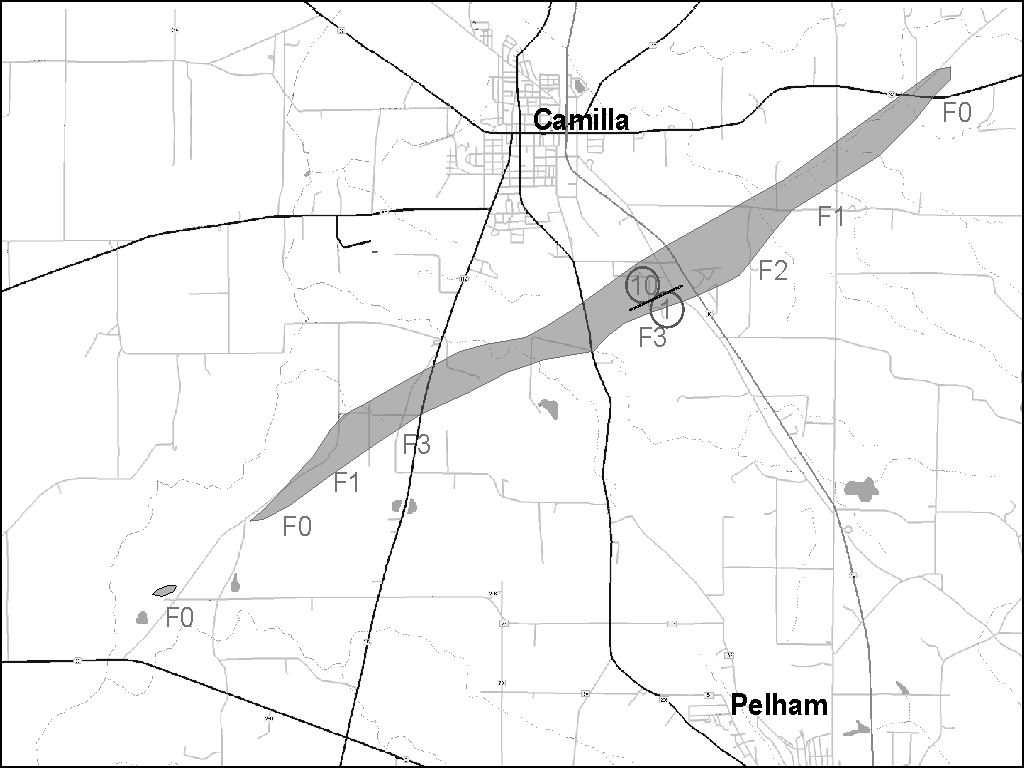
Fig. 4. Surveyed damage track (9.3 miles) for the Camilla tornadoes. F-scale damage and fatality locations (circled numbers) are also displayed. Short line marks only known touchdown point of second Camilla tornado.
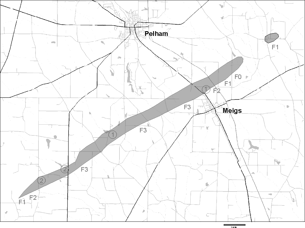
Fig. 5. Surveyed damage track (14.5 miles) of the Grady County tornado. F-scale damage and fatality locations (circled numbers) are displayed.
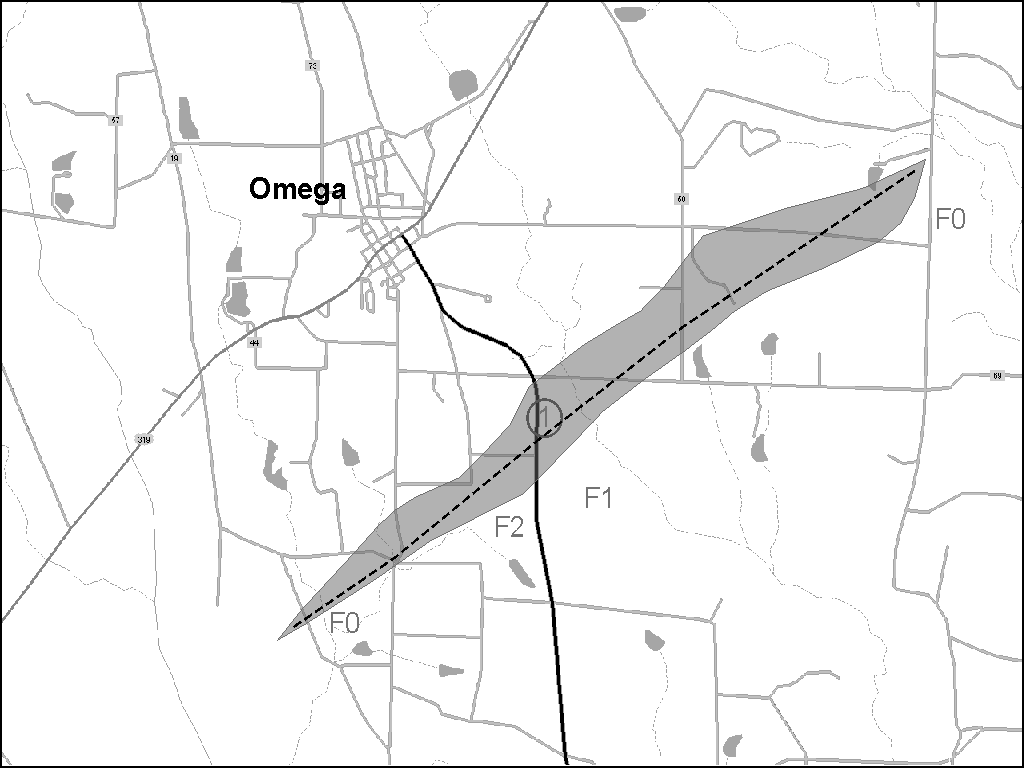
Fig. 6. Surveyed damage track (6 miles) of the Omega tornado. F-scale damage and fatality location (circled number) are displayed.
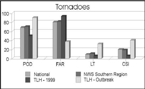
Fig. 7. Tornado statistics for this case compared to National, Southern Region, and Tallahassee WFO for 1999.


 Follow us on YouTube