
A few strong to marginally severe thunderstorms are possible across the Southeast U.S. Friday. A Marginal Risk (Level 1 of 5) outlook has been issued. Strong winds and hail will be the main threats. Elevated to locally critical fire weather conditions will persist across south-central Colorado today due to dry conditions and gusty winds. Read More >

Synopsis:
Synopsis for the state of Montana:
Current Hazards- Click On Left Menu For More Options
Snowfall - See Winter Probability Site Here
 |
| NWS Snow Event Forecast Click to Enlarge |
 |
 |
 |
|
Percent Chance of Measurable Snowfall |
Percent Chance of Snowfall Greater Than 2 inches |
Percent Chance of Snowfall Greater Than 6 Inches |
Precipitation (Liquid)
 |
| WPC 7-Day Liquid QPF Forecast Click to Enlarge |
 |
 |
 |
| Day 1 Liquid QPF Forecast Click to Enlarge |
Day 2 Liquid QPF Forecast Click to Enlarge |
Day 3 Liquid QPF Forecast Click to Enlarge |
Temperatures
 |
 |
 |
| Day 1 Forecast High Temperatures Click to Enlarge |
Day 2 Forecast High Temperatures Click to Enlarge |
Day 3 Forecast High Temperatures Click to Enlarge |
 |
 |
 |
| Tonight Forecast Low Temperatures Click to Enlarge |
Tomorrow Night Forecast Low Temperatures |
Night 3 Low Temperatures Forecast |
Wind Chill Forecast
 |
| 2 Day Wind Chill Forecast Click to Enlarge |
Wind Gusts
 |
| Maximum Wind Gust Forecast Click to Enlarge |
Ice Forecast - Central MT Only
 |
| NWS Snow Event Forecast Click to Enlarge |
Long Range Forecast
Day 4-7 Precipitation (Liquid)
|
| WPC 7-Day Liquid QPF Forecast Click to Enlarge |
 |
 |
 |
| Day 4 Liquid QPF Forecast Click to Enlarge |
Day 5 Liquid QPF Forecast Click to Enlarge |
Day 6 Liquid QPF Forecast Click to Enlarge |
Day 4-7 Temperatures
 |
|
| Day 4 Forecast High Temperatures Click to Enlarge |
Day 5 Forecast High Temperatures Click to Enlarge |
 |
 |
| Day 4 Forecast Low Temperatures Click to Enlarge |
Day 5 Forecast Low Temperatures |
Extended Range Forecast
 |
 |
|
Climate Prediction Center (CPC) 6-10 Day Temperature Outlook Click to Enlarge |
Climate Prediction Center (CPC) 6-10 Day Precipitation Outlook Click to Enlarge |
 |
 |
|
Climate Prediction Center (CPC) 8-14 Day Temperature Outlook Click to Enlarge |
Climate Prediction Center (CPC) 8-14 Day Precipitation Outlook Click to Enlarge |
*Note: Images are based on latest published forecast. Refresh browser for the most up to date forecast details.
 |
| The current Road Conditions from MTDOT. Click on the image or here for an interactive road conditions map. You can also dial 5-1-1 on your phone. Want a mobile app version of this information? Click here. |
 |
| Click on the image for an interactive road forecast travel map. Note...this site is currently a prototype and under development - not to be relied upon for operational decision making. |
 |
 |
 |
 |
|
Missoula Radar Loop Click to Enlarge |
Great Falls Radar Loop Click to Enlarge |
Billings Radar Loop Click to Enlarge |
Glasgow Radar Loop Click to Enlarge |
 |
 |
 |
 |
|
Regional Radar Loop Click to Enlarge |
Visible Satellite |
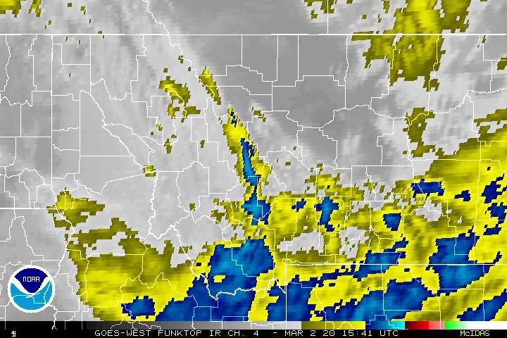
Infrared Satellite Click to Enlarge |
Water Vapor Satellite Click to Enlarge |


 Great Falls Radar
 Satellite
 Current Observations
 Forecast Discussion
 Montana Weather
 Fire Weather
 Winter Weather Forecasts
 Transportation Forecasts
 Weather Prediction Center
 Storm Prediction Center
 Aviation Weather
 Follow us on YouTube