National Weather Service United States Department of Commerce

Active Pattern for the Center of the Nation

Severe thunderstorms, excessive rainfall, critical fire weather are all in the outlook today and into this last weekend of April. Very large hail, severe wind gusts, and a couple strong tornadoes will all be possible across the central and southern Plains today. Flash flooding also possible for portions of the Plains and Mississippi Valley. Critical fire weather conditions for Southern High Plains Read More >

Click a location below for detailed forecast.

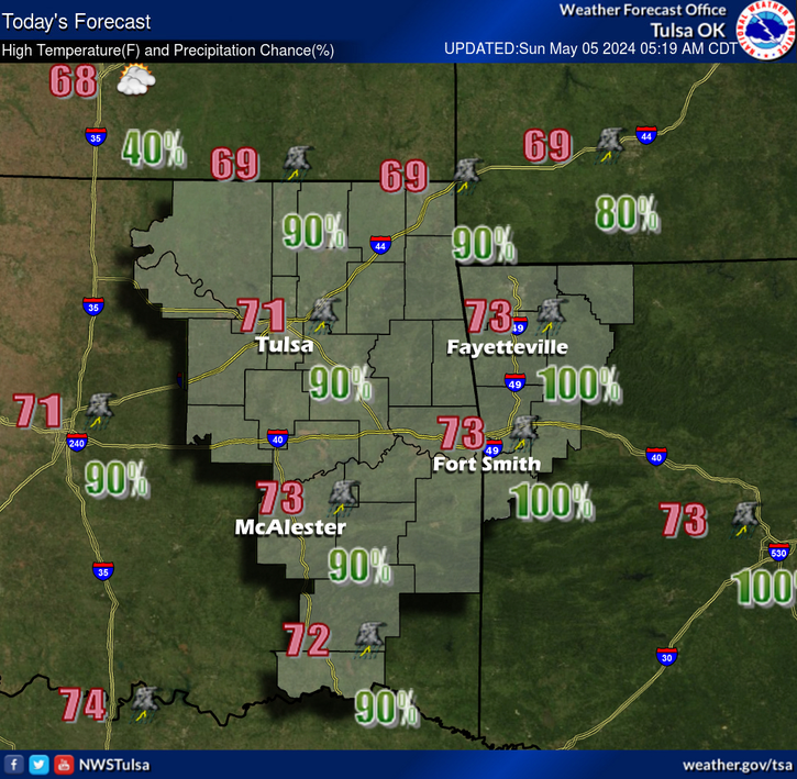
Last Map Update: Thu, Apr. 25, 2024 at 2:33:38 pm CDT

National Weather Service Goodland, KSNational Weather Service Wichita, KansasNational Weather Service Springfield, MO
National Weather Service Norman, OKZoom
Out

National Weather Service Little Rock, AR
National Weather Service Fort Worth/Dallas, TXNational Weather Service Fort Worth/Dallas, TXNational Weather Service Shreveport, LA
Strong to severe thunderstorms are expected to continue this morning and remain possible into this afternoon across northeast Oklahoma and Northwest Arkansas. Large hail will be the primary severe threat into this afternoon. Additional storms are forecast to develop out west and move into eastern Oklahoma late tonight. These late night storms will be capable of all modes of severe weather, including a limited tornado threat.
Severe storm threat continues Friday as thunderstorms are forecast to be ongoing across parts of eastern OK and northwest AR early Friday morning. This activity is expected to continue into the afternoon hours as it spreads through the region. Additional thunderstorm development Friday mid to late afternoon remains dependent on the amount heating and destabilization that can occur Friday afternoon. All modes of severe weather, including a limited tornado threat will be possible Friday.
Severe storm threat continues again Saturday across eastern Oklahoma and northwest Arkansas. Storms are forecast to develop out west and move into the region during the afternoon hours and continue into Saturday night. All modes of severe weather, including a limited tornado threat are possible Saturday afternoon into Saturday night.
Multiple rounds of heavy rainfall are forecast through Sunday night across eastern Oklahoma and northwest Arkansas. Three main rounds look to provide the greater amounts of rainfall with widespread 3 to 5 inches are forecast. Locally higher amounts are possible with a 10 percent chance of locally exceeding 8 inches by Sunday night. Multiple rounds of storms moving over the same locations will help to create a flash flood threat through the weekend. Continue to monitor latest forecasts as details are refined.
.Today...Mostly cloudy. Chance of showers and thunderstorms. Highs 63 to 82.
Latest Text Product Selector (Selected product opens in a new window)

Decision Support Hazards Models Observations Climate Hydrology
 
 
Social Media Satellite Fire Weather Weather Radio Spotter Training Text Products