
Isolated strong to severe thunderstorms capable of producing large hail and damaging wind gusts will be possible this evening across west-central Texas. Elevated to Critical fire weather conditions will persist across the southern Rockies and portions of the southern Plains through this weekend. Read More >
Winter 2012-2013 Highlights
The winter months of December - February across eastern Oklahoma and northwest Arkansas brought a mix of wintery and severe weather, with snow storms dropping several inches of snow, and severe storms producing hail, damaging winds, and tornadoes. The winter started out dry and cool, with below normal temperatures and below normal precipitation in December. By February, average temperatures were near normal, with above normal precipitation, helping to alleviate the persistent drought across the region.
Temperatures . . .
The following line graphs depict the mean temperature for the months of December - February (in blue) along with the expected mean temperature (in red) for Tulsa, OK, Fort Smith, AR and Fayetteville, AR. The mean temperatures were taken from 1980 - 2010.
 |
 |
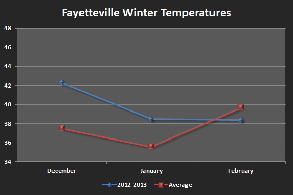 |
The three sites follow much the same pattern, with this seasons temperatures above normal for December and January, followed by normal to slightly below normal temperatures in February. The start of winter was very warm, with well above normal temperatures for the first week of December. Several new high temperature records were set, including Dec 1-2 for Tulsa and Dec 2-3 for Fort Smith and Fayetteville. January temperatures remained warm, with mean temperatures for the month running about 3-4°F above normal. Conditions cooled for February, with the increased rainfall, dropping average temperatures back to, or slightly below normal.
Precipitation . . .
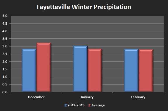
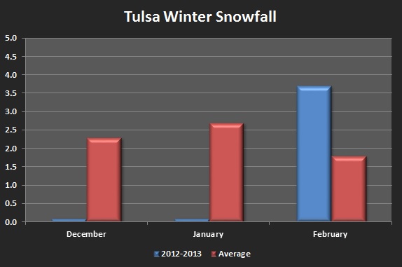
The following bar graphs depict the mean precipitation and snowfall for the months of December - February (in blue) along with the expected mean precipitation and snowfall (in red) for Tulsa, OK, Fort Smith, AR and Fayetteville, AR. The mean precipitation and snowfall amounts were taken from 1980 - 2010.
 |
 |
 |
 |
 |
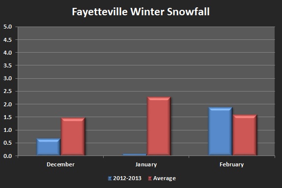 |
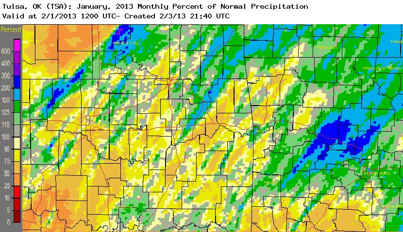
First, looking at the precipitation amounts (top row), December brought below normal (Tulsa) to slightly below normal (Fort Smith and Fayetteville) moisture amounts. Tulsa only received 0.85", which is 1.64" below normal. As we went into the months of January and February, precipitation amounts increased, helping to alleviate the persistent drought conditions across the region. Tulsa had the 12th wettest February on record, with nearly 60% extra rainfall. Unlike the winter season of 2011-12, the forecast area received much more snow this season. Tulsa saw 3.7" (1.7" last season), Fort Smith saw 8.0" (2.0" last season), and Fayetteville saw 2.6" (0.8" last season). Even if Fort Smith does not receive any additional snowfall in March or April, it will rank 31st snowiest winter with 8.0".
Drought Progression . . .
The following chart depicts the amount of precipitation that fell leading up to, and during the winter months, and how that impacted the current drought across the area. The first image is the amount of rainfall that fell during the month (observed precipitation). The second image is the percentage of expected rainfall that fell during the month (percent of normal). The third image is the state of drought near the end of that month (drought progression).
| Observed Preciptation | Percent of Normal | Drought Progression | |
| November 2012 |  |
 |
November 27, 2012 |
| December 2012 |  |
 |
December 25, 2012 |
| January 2013 |  |
 |
January 29, 2013 |
| February 2013 |  |
 |
February 26, 2013 |
At the end of fall 2012, the region was still experiencing a persistent drought, with much of the forecast area under a D3 (extreme) or greater drought. During the month of November, nearly all of the forecast area received less than 50% of the normal precipitation, continuing or worsening the drought conditions as we transitioned into winter. December precipitation remained below normal for most of eastern Oklahoma and northwest Arkansas, especially across northeast Oklahoma where the drought increased to D4 (exceptional) in some locations. January brought some relief for portions of the forecast area, mainly western Arkansas (Fort Smith received over an inch of above normal rainfall), helping to lessen the drought there. Above normal precipitation fell across much of eastern Oklahoma during the month of February, helping to reduce the drought severity by one whole grade, taking it from a mixture of D3 and D4 levels, to D2 and D3.
Averages and Records . . .
Below are tables for Tulsa, OK, Fort Smith, AR and Fayetteville, AR with monthly averages and records for temperatures, precipitation, and snowfall for the winter months of December - February, along with a winter seasonal average.
Tulsa:
| Tulsa, OK |
Average Temperature |
Departure from Normal |
Rank | Record | Precipitation | Departure from Normal | Rank | Record | Snowfall | Departure from Normal | Rank | Record | ||
| December 2012 | 43.6°F | +4.1°F | 18th warmest | 47.3°F 1931 | 0.85" | -1.64" | 30th driest | 0.00" 1889 | Trace | -2.3" | 28th driest | 11.4" 2000 | ||
| January 2013 | 40.5°F | +2.8°F | 25th warmest | 48.4°F 2006 | 1.54" | -0.12" | 70th driest | 0.00" 1986 | Trace | -2.7" | 12th driest | 12.7" 1979 | ||
| February 2013 | 41.0°F | -1.3°F | 48th coolest | 27.5°F 1905 | 3.18" |
+1.33" |
12th wettest | 5.74" 1985 | 3.7" | +1.9" | 27th snowiest | 22.5" 2011 | ||
| Winter Season | 41.7°F | +2.0°F | 25th warmest | 46.1°F 1931-32 | 5.57" | -0.43" | 71st driest | 1.59" 2005-06 | 3.7" | -3.1" | - | - |
Fort Smith:
| Fort Smith, AR | Average Temperature | Departure from Normal | Rank | Record | Precipitation | Departure from Normal | Rank | Record | Snowfall | Departure from Normal | Rank | Record | ||
| December 2012 | 46.2°F | +4.9°F | 13th warmest | 57.7°F 1889 | 2.75" | -0.54" | 69th driest | 0.09" 1908 | 4.0" | +3.2" | 9th snowiest | 8.3" 1916 | ||
| January 2013 | 43.2°F | +3.8°F | 20th warmest | 48.9°F 1923 | 3.97" | +1.16" | 23rd wettest | 11.33" 1949 | Trace | -2.4" | 29th driest | 13.6" 1918 | ||
| February 2013 | 44.6°F | +0.4°F | 53rd warmest | 53.0°F 1930 | 4.46" | +1.70" | 25th wettest | 10.72" 1884 | 4.0" | +2.9" | 22nd snowiest | 18.3" 1921 | ||
| Winter Season | 44.7°F | +3.1°F | 16th warmest | 50.8°F 1889-90 | 11.18" | +2.32" | 21st wettest | 21.06" 1948-49 | 8.0" | +3.7" | - | - |
Fayetteville:
| Fayetteville, AR | Average Temperature | Departure from Normal | Rank | Record | Precipitation | Departure from Normal | Rank | Record | Snowfall | Departure from Normal | Rank | Record | ||
| December 2012 | 42.3°F | +4.8°F | 10th warmest | 45.8°F 1984 | 2.85" | -0.39" | 35th driest | 0.26" 1955 | 0.7" | -0.8" | 42nd driest | 6.0" 2000 | ||
| January 2013 | 38.5°F | +2.9°F | 15th warmest | 44.9°F 2006 | 3.03" | +0.19" | 18th wettest | 9.17" 1998 | Trace | -2.3" | 11th driest | 14.0" 1977 | ||
| February 2013 | 38.4°F | -1.3°F | 26th coolest | 28.9°F 1978 | 2.82" | +0.01" | 29th wettest | 8.60" 1990 | 1.9" | +0.3" | 27th snowiest | 18.8" 2011 | ||
| Winter Season | 39.8°F | +2.3°F | 16th warmest | 43.0°F 1991-92 | 8.70" | -0.19" | 42nd driest | 2.84" 1958-59 | 2.6" | -2.8" | - | - |
Weather Highlights . . .
Here are a few of the more significant events of the winter season 2012-13, including winter weather of snow and ice, as well as severe weather in both December and January.
 |
 |
 |
|
December 19 - Severe Weather Event Photo Credit: NWS Tulsa, OK |
December 25 - Snowfall Event Photo Credit: NWS Tulsa, OK |
December 28 - Snowfall Event Photo Credit: NWS Tulsa, OK |
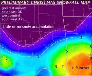
December started out very warm, with spring-like conditions, which led to severe weather occurring during the evening on December 19th. A line of severe thunderstorms developed across eastern Oklahoma, and moved toward the east, producing large hail and damaging winds across southeast Oklahoma and western Arkansas. A tornado formed out of one of these storms in northern Sebastian County, damaging numerous trees, along with several homes and outbuildings. The tornado was on the ground for about 3 miles, and was rated an EF-1, with winds between 95 and 105 miles per hour. The first chance for accumulating snowfall arrived Christmas Day, as a strong low pressure system moved over the region. While we initially thought most of the snow would fall along and south of the highway 40 corridor, the system tracked a little more south than expected, shifting the snow band across southeast Oklahoma and western Arkansas. Central Le Flore County received 8 inches, and Fort Smith received 4 inches, while Tulsa and Fayetteville only received a trace. A few days later, a second system brought another round of snow to portions of far eastern Oklahoma and northwest Arkansas. Amounts were much lighter, with accumulations reaching 1 inch near Stilwell, OK and Eldon, OK, as well as Bella Vista, AR and Fayetteville. Tulsa and Fort Smith only received a trace.
 |
 |
|
January 12 - Snowfall Event Photo Credit: NWS Tulsa, OK |
January 29 - Severe Weather Event Photo Credit: NWS Tulsa, OK |
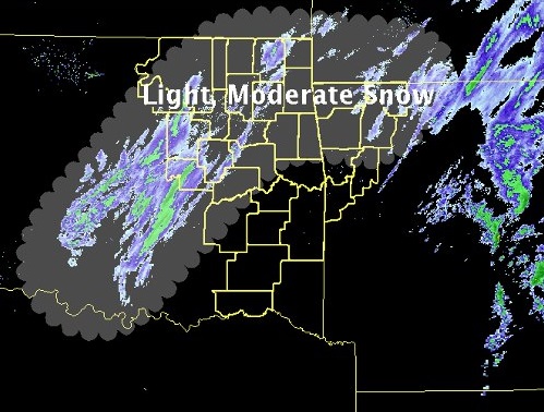
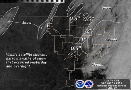
The month of January brought both winter and severe weather with snowfall on January 12th, and 3 tornadoes on January 29th. On January 12th, a low pressure system moved into the area, dropping small amounts of snow over the forecast area. Though most of the snow fell north of the Kansas and Missouri borders, a couple swaths of snow were observed the following day using satellite data. One swath extended across the far western portions of Osage and Pawnee counties, while the other spread from near Jay, OK southwest toward Checotah, OK. Snowfall amounts topped out at 2 inches in Delaware County. Tulsa, Fort Smith, and Fayetteville all received a trace of snowfall. Unusually warm and spring-like weather triggered severe storms on January 29th, as a low pressure system and cold front pushed across the area. 3 tornadoes were reported in far eastern Oklahoma and northwest Arkansas. The first started in far northeast Sequoyah County a little before 3pm, and tracked northeast for about 9 miles, damaging numerous trees, along with power poles and 1 home. This tornado was ranked an EF-2, with winds of 110-120 mph. The second tornado occurred NW of Elkins in Washington County, AR about 3:34 pm, and damaged between 40-50 homes, some losing their roofs. The tornado was ranked an EF-1, with winds between 95-105 mph. The third tornado touched down north of Rockhouse in Madison County, AR about 3:57pm. Numerous trees were snapped, along with several barns and a couple homes giving it an EF-1 ranking with winds between 100-110 mph.
 |
 |
 |
|
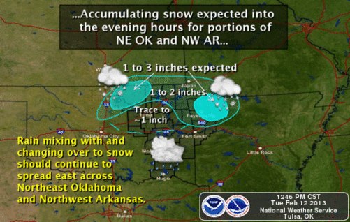
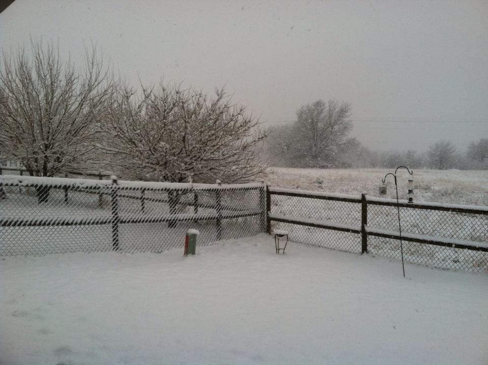
February 12,13 - Snowfall Event Photo Credit: NWS Tulsa, OK |
February 20, 21 - Snowfall Event Broken Arrow, OK - 2.8 inches Photo Credit: NWS Tulsa, OK Employee |
February 25, 26 - Snowfall Event Photo Credit: NWS Tulsa, OK |
February brought several snow events starting the evening of February 12, when a system affected northeast Oklahoma and northwest Arkansas, dropping several inches of snow, mainly near the Kansas border, and across the higher terrain of northwest Arkansas. Snowfall amounts included 3 inches in Osage County, 2 inches in Washington County, along with 2 to 3 inches in Benton and Madison counties. Tulsa received 0.1 inches, Fort Smith 0.0, and Fayetteville a trace. Another snow storm moved over the region on February 20th and 21st, bringing a mix of snow, sleet, and freezing rain to the area. Some locations in northwest Arkansas lost power due to downed power lines and tree limbs. Snowfall totals of 4 inches or greater included Sequoyah, Delaware, Okfuskee, Le Flore, Crawford, and Sebastian counties. Ice accumulations of at least a quarter of an inch were reported in Madison, Benton, Carroll, Osage, and Washington counties. Sleet accumulations of an inch were reported in Carroll and Madison counties. Tulsa received 3.2 inches, Fort Smith 4.0 inches, and Fayetteville 1.4 inches. A third low pressure system affected the region toward the end of the month during February 25th and 26th. Whiteout conditions were reported in Pawnee County in northeast Oklahoma, as strong winds of 44mph reduced visibilities. Snowfall amounts ranged from 5 inches in Osage County, 4 in Washington County, 3 inches in Nowata, Ottawa, and Benton counties. Tulsa received 0.4 inches, Fort Smith 0.0, and Fayetteville 0.5 inches.
Spring 2013 Forecast . . .
Below is a chart with the Climate Prediction Center's forecast for both temperatures and precipitation for the spring 2013 season, along with the seasonal drought outlook. For temperatures, there is an increased chance of above than normal temperatures for the entire forecast area, including all of eastern Oklahoma and northwest Arkansas. For precipitation, while western Oklahoma has a slight chance for below normal precipitation, eastern Oklahoma and northwest Arkansas show an "equal chance" rating. This means that there are no indications that the precipitation amounts will be either above or below normal, thus normal precipitation, below normal, and above normal are all equally likely. The third image depicts the drought outlook for the nation, and places eastern Oklahoma in the persistent or intensifying drought category, while northwest Arkansas should expect ongoing drought conditions with slight improvement possible.
 |
 |
 |
| Spring 2013 Temperature Outlook | Spring 2013 Precipitation Outlook | Spring 2013 Drought Outlook |
Updated: March 27, 2013


 Follow us on YouTube