
Isolated strong to severe thunderstorms capable of producing large hail and damaging wind gusts will be possible this evening across west-central Texas. Elevated to Critical fire weather conditions will persist across the southern Rockies and portions of the southern Plains through this weekend. Read More >
July 23-24, 2013: Derecho and Flooding Event
Information on this webpage is considered preliminary.
| Jump to: | Event Summary | SPC Data | Wagoner Tornado | SPC Storm Reports | Event Images, Maps, and Data |
Event Summary:
Severe thunderstorms developed during the late afternoon and evening hours of July 23rd over southern Kansas. The airmass was extremely hot and unstable south of these storms where afternoon heat indices reached 110 degrees. An upper-level disturbance moved southeastward during the evening, and helped drive a complex of severe storms into eastern Oklahoma between 10pm and 3am.
The severe storms had a history of producing wind gusts to 80mph earlier in the evening in the Wichita area, and they continued to do the same as the complex moved into the Tulsa area. The Tulsa International Airport recorded a 76 mph wind gust as the storms rolled in, the highest ever recorded at the site.
The damaging winds pushed across Tulsa and surrounding areas, causing widespread tree and power line damage leaving over 100,000 without power during the overnight and early morning hours. An EF-1 tornado developed along the leading edge of the bow west of Wagoner, snapping or uprooting several trees, and damaging some buildings and homes. The bow echo or derecho continued southward reaching Choctaw County shortly after 2am.
Heavy rains also fell during the night, with some flooding reported in the Tahlequah and Miami areas. The heaviest rains fell along the Oklahoma-Arkansas border where between 3 to 5 inches fell.
| Radar Loop From Between 11:30 pm - Midnight July 23, 2013 |
 |
Preliminary Tornado Information (last updated 3:15 pm 07/29/2013):
Information from this event is still considered preliminary. Anyone with information that could enhance the record of this event should contact the National Weather Service Office in Tulsa at 918-838-7838 during business hours, or send us an email at sr-tsa.stormreport@noaa.gov.
Images related to each tornado can be enlarged by clicking. Hover your mouse over the image for a caption.
| Wagoner Tornado (Wagoner County OK) | ||
| EF-Scale | EF-1 |
Damage:
|
| Maximum Estimated Wind Speed | 90-100 mph |
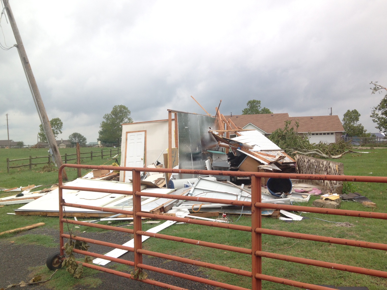
A tornado developed on the leading edge of the line of thunderstorms that moved through northeastern Oklahoma during the late evening of the 23rd and early morning of the 24th. The tornado developed just north of Highway 51, about 3 miles west of downtown Wagoner, where it produced minor damage to trees and outbuildings. As it moved southeast and crossed Highway 51, it tore a large section of roof from a large metal building, damaged the roof of a wood-framed office building, and destroyed portions of two wood-framed storage units. Several homes received damage to their roofs and siding, barns were damaged or destroyed, and large tree limbs were snapped in this area. The tornado produced minor damage to homes and light tree damage until it neared Higheay 69. Several trees were uprooted to the north, a travel trailer was blown 35 yards to the north-northeast, a number of homes received roof damage, and numerous large tree limbs were snapped along and near Highway 69. Several businesses also received damage to their roofs. Other homes were damaged south of SW 15th Street, an apartment complex received roof damage, and trees had large limbs snapped as it moved southeast before dissipating west of Highway 16. Other wind damage was noted by the survey team around Wagoner, but this was part of a broader swath of wind damage associated with the line of thunderstorms. |
| Path Length | 3.5 miles | |
| Maximum Path Width | 850 yards | |
| Start Location and Time | 3.3 miles west of Wagoner, OK at 12:06 am CDT July 24, 2013 | |
| End Location and Time | 1.7 miles south of Wagoner, OK at 12:12 am CDT July 24, 2013 | |
Here is a link to the Storm Prediction Center's (SPC) severe weather report map showing all the severe hail, wind, and tornado reports from July 23.
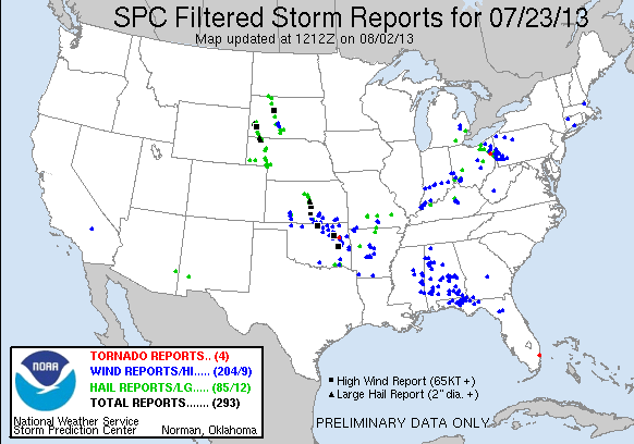 |
Click on image for larger version in a new window.
Event Images, Maps, and Data:
| 24-hr Rainfall Amounts Ending 7am July 24 | Strongest Measured Winds July 23 - July 24 | |||
| Poteau 1ENE, OK | 5.20" | Tulsa - near 37th & Nogales - July 23 at 11:45 pm | 91 mph | |
| Tahlequah 4NNW, OK | 5.18" | Tulsa International Airport - July 23 at 11:42 pm | 76 mph | |
| Wister 3ENE, OK | 4.56" | Burbank Mesonet - July 23 at 10:54 pm | 73 mph | |
| Barber 3NE, OK | 4.00" | Tulsa Mesonet - July 23 at 11:40 pm | 71 mph | |
| Pryor 7ESE, OK | 3.60" | Foraker Mesonet - July 23 at 10:50 pm | 66 mph | |
| Locust Grove 4S, OK | 3.55" | Wynona Mesonet - July 23 at 11:04 pm | 66 mph | |
| Van Buren, AR | 3.08" | Hectorville Mesonet - July 24 at 12:04 am | 66 mph | |
| Jay 3NNE, OK | 3.05" | Tulsa - near 121st & Peoria - July 23 at 11:43 pm | 60 mph | |
| Rogers Municipal Airport - July 23 at 10:17 pm | 59 mph | |||
| Tulsa, OK | 0.63" | Burbank Mesonet - July 23 at 10:50 pm | 58 mph | |
| Fort Smith, AR | 2.94" | |||
| Fayetteville, AR | 1.03" | |||
 |
 |
|
24-hr Rainfall Amounts Ending at 7am July 24th Photo Credit: NWS Tulsa, OK |
Tulsa, OK Storm Damage Photo Credit: AP |
 |
|
|
Wagoner County, OK EF-1 Tornado Damage Photo Credit: NWS Tulsa, OK |
Updated: July 29, 2013


 Follow us on YouTube