Overview
|
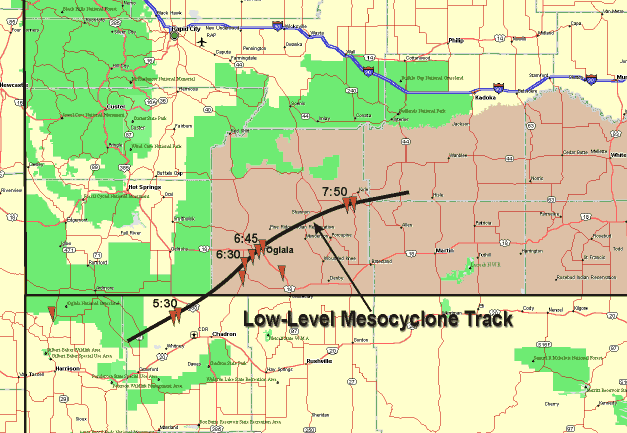
A deadly tornadic storm moved across southwestern South Dakota during the late afternoon and evening of 4 June, 1999. Multiple tornadoes were observed from several supercells that moved toward the northeast from west of Chadron, NE, to near Kyle, SD between 5:30 and 8 pm MDT. The most severe damage occurred where the paths of these storms passed near the community of Oglala, SD. The figure to the right illustrates the preliminary locations of sighted tornadoes and/or tornadic damage, as well as the path of the primary circulation (mesocyclone) within the Oglala storm that produced the tornadoes. As can be seen in the graphic, the storm that affected Oglala initiated to the west of Chadron, NE (radar imagery indicated it was a "classic" supercell). The first sighting of a tornado was around 5:30 pm, north of Whitney, NE. This storm (and another supercell that developed close to its southwest) moved into extreme southeastern Fall River county and southwestern Oglala Lakota county between 5:45 and 6:00 pm MDT. Several sightings of tornadoes (likely of the same one or two tornadoes) were made around 6:30 as the storms moved to the west-northwest of Pine Ridge (5–10 miles southeast of Oglala). As the storm moved toward Oglala between 6:33 and 6:40 pm, heavy rain and hail wrapped around the tornado making sighting difficult, if not impossible. As the tornadic storm moved through the Oglala area between 6:40 and 6:50 pm, residents observed that the sky was black with rain and hail with very low visibility. After the storm passed Oglala, the Rapid City WSR-88D radar indicated that the storm circulation weakened somewhat as it merged with the other supercell storm just to its south. The storm reorganized into a larger, "high-precipitation" supercell south of Sharps Corner around 7:15 pm. Soon after this time, another tornado (with multiple sightings) formed east of Sharps Corner, about 5 miles to the southwest of Kyle, SD. This was the last observed tornado from this storm, though radar indications suggest that it may have remained tornadic as it approached the Hisle area in Jackson County. |
|
Tornadoes:
|
Tornadoes - Kyle, Martin, Oglala, Pine Ridge, and Slim Buttes
Track Map 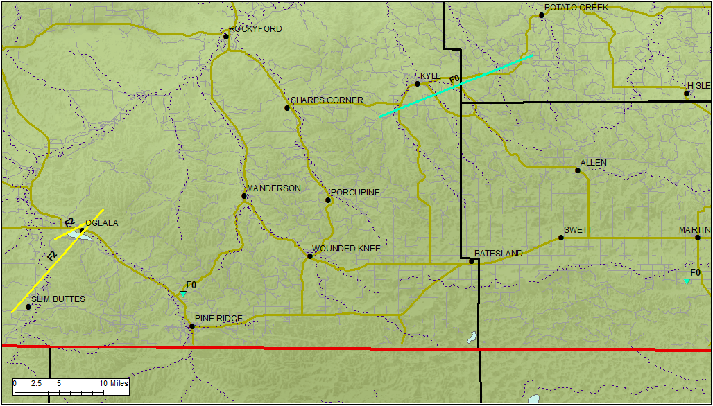  |
||||||||||||||||
Tornado ratings are assigned based on the amount of damage they cause. The tornadoes in Oglala Lakota, Jackson, and Bennett Counties were rated using the original Fujita tornado damage scale (http://www.spc.noaa.gov/faq/tornado/f-scale.html). In 2007, the National Weather Service began using the Enhanced Fujita (EF) scale (http://www.spc.noaa.gov/faq/tornado/ef-scale.html), which is an updated F-scale developed by a team of meteorologists and wind engineers.
The Enhanced Fujita (EF) Scale classifies tornadoes into the following categories:
| EF0 Weak 65-85 mph |
EF1 Moderate 86-110 mph |
EF2 Significant 111-135 mph |
EF3 Severe 136-165 mph |
EF4 Extreme 166-200 mph |
EF5 Catastrophic 200+ mph |
 |
|||||
Additional Facts
Photos
NWS Storm Survey Photos
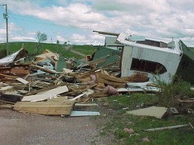
Drs. Brian Klimowski and Matthew Bunkers from the NWS office in Rapid City, SD, went to the Oglala area early on June 5 to conduct a damage survey and assess the severity of this event. The damage that was observed generally was in the F1-F2 range, with the most severe damage just to the east of the main intersection in Oglala. One, or perhaps two, tornadoes were responsible for the most severe damage.
With the lack of trees and structures in the area, it was difficult to identify any "path" of the tornado(es). If the tornado was retrograding at the time it struck Oglala (moving westward as it was rotating around the mesocyclone), the damage could have been caused by one tornado. However, if the tornado(es) were moving with the storm and low-level circulation, there likely would have been two tornadoes to explain the damage that was observed over the Oglala area.
The area in and around Oglala also experienced very strong straight-line winds from the north to northwest, which accounted for F1-type damage on the western and northern parts of Oglala. The images below are typical of what was observed north and south of the main intersection in Oglala, where F1-type damage was noted.
|
|
 |
 |
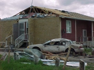
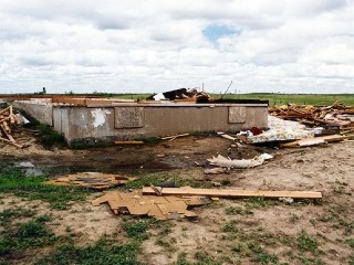
Further to the east, several locations experienced F2-type damage. The spread of the debris indicated that there was one, and perhaps two F2 tornadoes that affected the area. One such area was near the primary church in town. Below, you can see a mix of F1 and F2 damage---from the movement of framed structures off their foundations (below left), to the destruction of an unsecured framed structure that was tossed 80 feet (below middle), and the destruction of a mobile home that was sheltered within trees (below right).
 |
 |
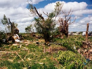 |
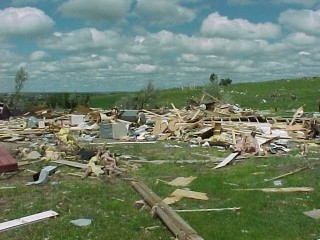
One-half to three-quarters of a mile further to the east there was a more continuous region of severe (F2) damage. In this area, all of the telephone and utility poles were snapped and tossed, mobile homes were thrown over 100 yards (below left and middle) with debris strewn over a quarter of a mile, and a relatively "new" framed house was leveled (below right), with wood projectiles in the ground 100 yards downstream.
 |
 |
 |
Radar
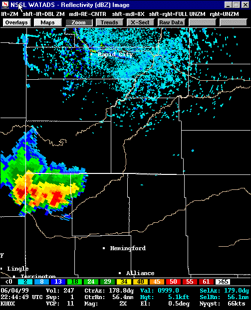
Radar images from the Oglala tornado event are below. The first image (below left) shows the storms as they appeared at 5:29 pm MDT, close to the time that the first tornadoes were reported in Nebraska. Though the storm was quite distant from the radar at this time, it exhibited may classic features of a severe supercell, including strong rotation, an appendage (possibly a "hook"), and a bounded weak echo region (BWER, below right).
 |
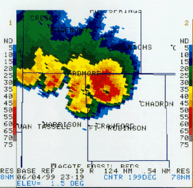 |
| Radar reflectivity at 5:29 pm MDT on June 4, 1999 | Radar reflectivity at 1.5 degree elevation at 5:19 pm MDT on June 4, 1999 |
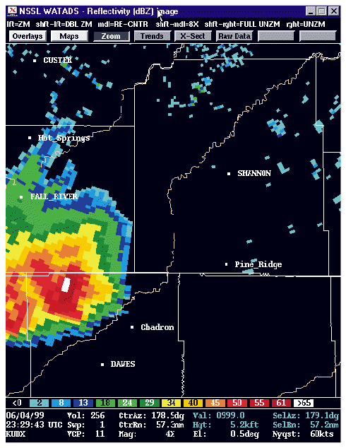
An hour later, at 6:29 pm MDT (below) we received our first confirmation of a tornadoes in South Dakota. At this time, two tornadoes were reported west of Pine Ridge. The Doppler velocity image (below right) shows two areas of high gate-to-gate shear, indicating the possible position of these two tornadoes. The northernmost tornado was within the well-formed hook echo west-northwest of Pine Ridge. Note a second supercell to the southwest of the first storm, just entering South Dakota at this time (below left). This second storm also exhibited a hook echo, and eventually produced a tornado about 5 miles north of Pine Ridge.
 |
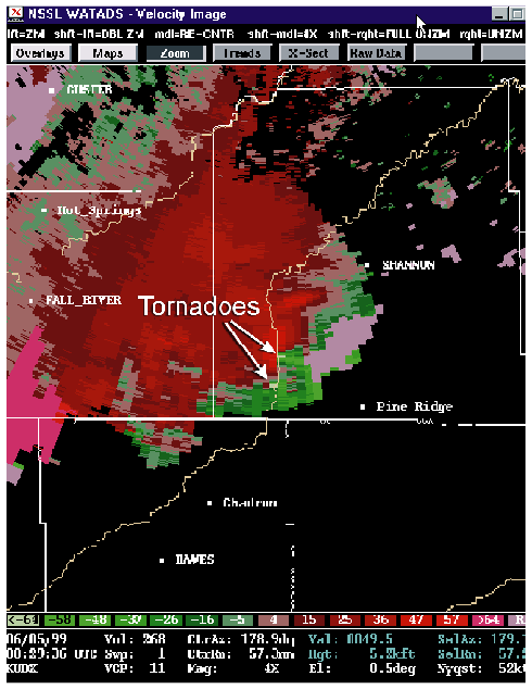 |
| Radar reflectivity at 6:29 pm MDT on June 4, 1999 | Radar velocity at 6:29 pm MDT on June 4, 1999 |
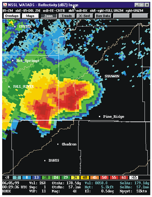
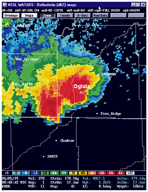
At 6:40 pm, the tornadic storm moved into the Oglala area. The radar images below show that the extremely strong low-level circulation was just to the south of Oglala at this time. This coincides well with the damage which was observed in the area, with the most severe damage located just to the south and east of the main Oglala intersection.
 |
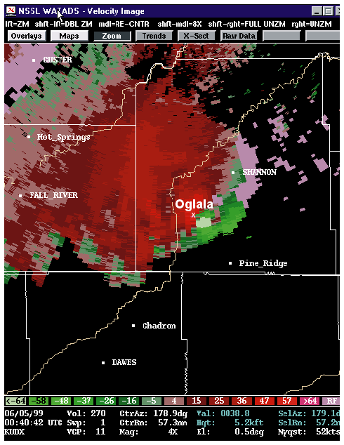 |
| Radar reflectivity at 6:40 pm MDT on June 4, 1999 | Radar velocity at 6:40 pm MDT on June 4, 1999 |
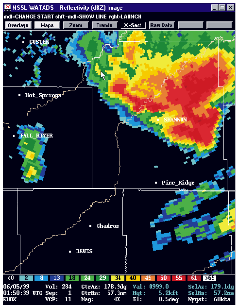
The two storms that passed through the Oglala area slowly merged into one storm from 7 to 7:45 pm. At 7:50 pm, the storm assumed "high precipitation" supercell characteristics, with much precipitation wrapping around the mesocyclone. Several tornadoes also were sighted at this time near the town of Kyle. In summary, the loop of radar images (below right) demonstrates the evolution of the Oglala tornadic supercell.
 |
 |
| Radar velocity at 7:50 pm MDT on June 4, 1999 | Reflectivity loop from 4:54 to 8:10 pm MDT on June 4, 1999 |
Environment
The 4 June tornadic supercell developed within an environment which demonstrated the classic features for a tornadic event, including strong instability, high low-level moisture, strong vertical wind shear, and a midlevel short-wave trough moving through the area. This brief discussion discusses these features as they were exhibited during the 4 June Oglala tornado event. Data from 00Z on June 5th (6 pm MDT on June 4th) were used for most of the analyses.
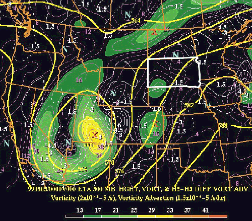
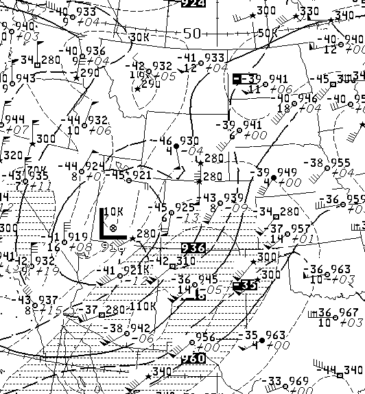
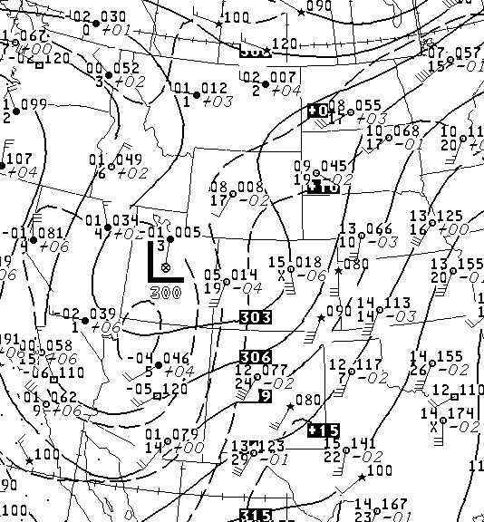
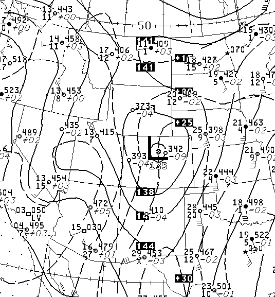
Beginning with the higher levels of the atmosphere, the 500 mb height / vorticity at 00Z (below, from the 00Z analysis of the ETA model) exhibited an unseasonably strong and deep trough over the southwestern United States, with nearly meridional flow through the panhandle of Nebraska and western South Dakota. A relatively strong short-wave trough was evident in this flow moving to the north through the Panhandle of Nebraska and southwestern South Dakota. These features also are well-represented in the DIFAX charts at 300mb, 500mb, 700mb, and 850mb (see below).
 |
 |
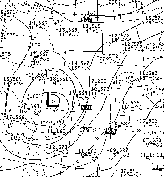 |
| Eta 500 mb heights/vorticity and vorticity advection at 00z on June 5, 1999 | 300 mb DIFAX upper-air map at 00z on June 5, 1999 | 500 mb DIFAX upper-air map at 00z on June 5, 1999 |
 |
 |
| 700 mb DIFAX upper-air map at 00z on June 5, 1999 | 850 mb DIFAX upper-air map at 00z on June 5, 1999 |
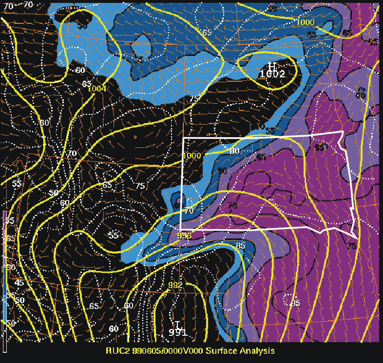
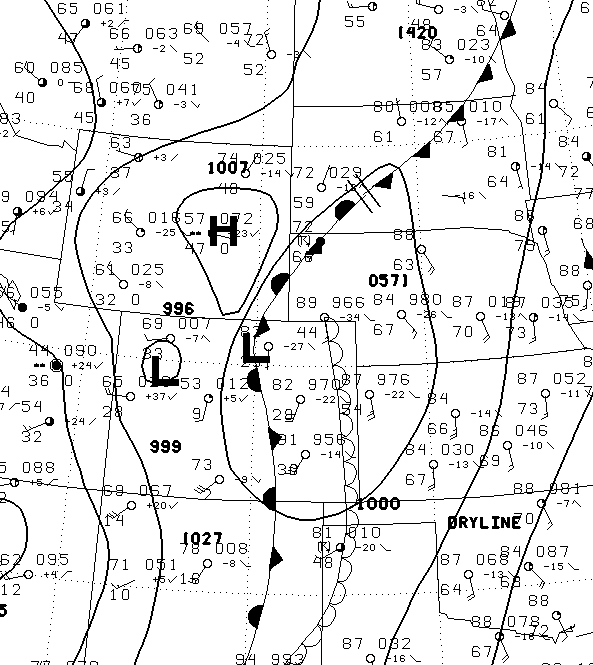
The upper-level flow above the surface fostered the development of a strong surface low pressure over northeastern Colorado, which wrapped copious moisture westward into southwestern and central South Dakota. This is evident in the RUC surface analysis (below left) by the high dewpoints (shaded) that were in the upper 60s and lower 70s in this area. The copious surface moisture, combined with the relatively cool atmosphere aloft, created a locally very unstable atmosphere (below right). Lifted Indices of less than –10 C were present over the area, with CAPE of 2500 to 3000 J/kg. The most severe storms formed and moved mostly along the instability axis that extended from southwestern South Dakota to south-central South Dakota.
 |
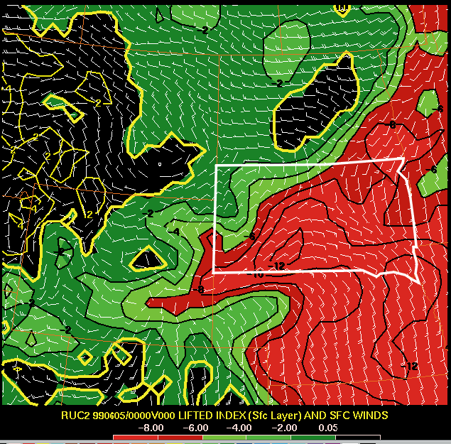 |
| RUC surface MSLP, dewpoint, and wind analysis valid at 00z on June 5, 1999 | RUC lifted index and surface wind analysis valid at 00z on June 5, 1999 |
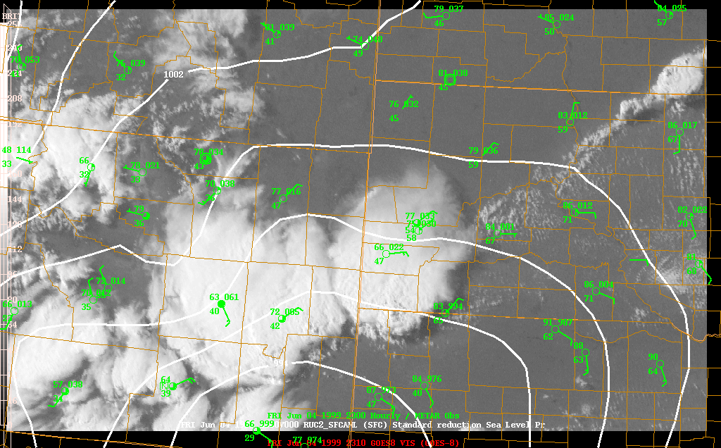
The visible satellite image and surface observation composite at 23z (5 pm MDT) shows the relationship between the position of the thunderstorms that were forming in northwestern Nebraska to the surface features (below left). As can be inferred from the surface analyses above, and the observations in the image below, an area of convergence was present along the moisture gradient north of the axis of highest dewpoints in western South Dakota. A well-defined line of cumulus (as well as the thunderstorms that later became the Oglala storm) was oriented along this region of convergence (moisture gradient), which extended from south of Douglas, WY, northeastward to north of Aberdeen, SD. Note also the position of the surface low pressure (MSLP contoured in white) south of the tornadic storms. This is a common orientation for northern plains tornadic events. You may also want to check out the DIFAX surface chart at 00Z (below right).
 |
 |
| Visible satellite, surface observations, and MSLP at 5 pm MDT (23z) on June 4, 1999 | Surface map at 6 pm MDT on June 4th (00z on the 5th) |
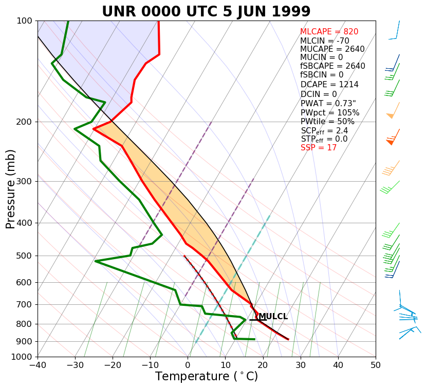
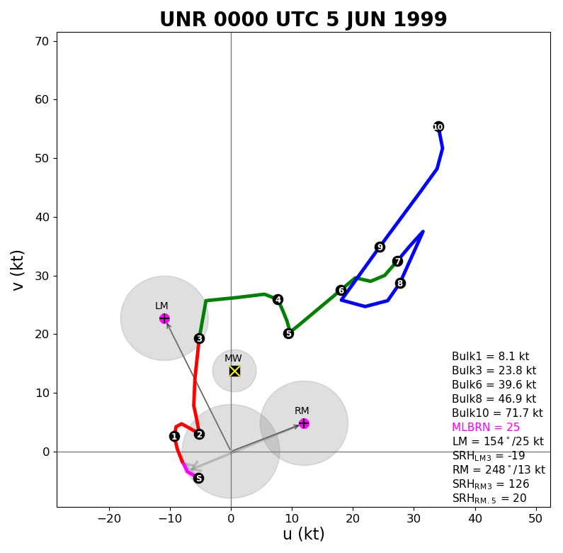
The aspect of the vertical profile of the wind (wind shear) is critical in determining what types of storms will form on a given day. During the evening of June 4th, there was strong wind shear between the surface and 6 km AGL, with values of 44 to 50 m/s (as demonstrated by the hodographs from the Rapid City balloon information, and the Merriman, NE, profiler). In addition to the strong shear, the storm-relative helicity was high in both wind profiles, ranging from 125 to nearly 500 m2/s2.
 |
 |
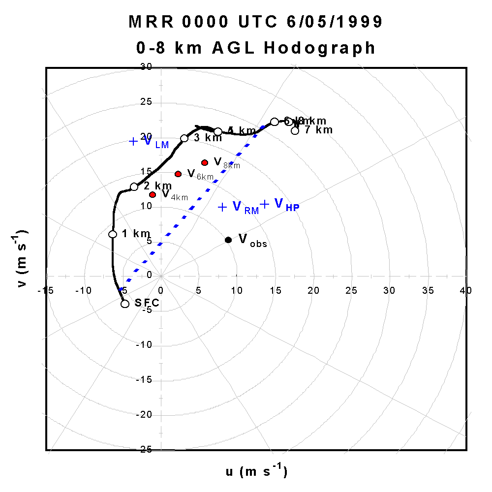 |
| Sounding for Rapid City at 6 pm MDT 4 June 1999 (00z the 5th) | Hodograph for Rapid City at 6 pm MDT 4 June 1999 (00z the 5th) | Hodograph for Merriman, NE, at 6 pm MDT 4 June 1999 (00z the 5th) |
 |
Media use of NWS Web News Stories is encouraged! Please acknowledge the NWS as the source of any news information accessed from this site. |
|


 Follow us on YouTube