Overview
Effective Tuesday, October 15, 2019, at 100 PM Central Daylight Time, or 1800 Coordinated Universal Time (UTC), the National Weather Service Weather Forecast Office in Rapid City, SD (UNR) will modify fire weather zone boundaries across northeastern WY and western SD. The purpose of this change is to better meet the needs of fire partners and improve fire weather support, including improved watch, warning, and forecast products.
WFO UNR has fire weather responsibility for much of northeastern WY and western SD. There has been significant improvement in forecast models since 2004, which is the last time WFO UNR changed zone boundaries. Based on model improvement and climatology, shrinking some of the larger fire weather zones and reworking zone boundaries in the Black Hills will result in more representative forecasts for each fire zone. After many consultations with the Great Plains Interagency Dispatch Center Operations Committee and Board of Directors, and other local, state, federal, and tribal partners, changes to all fire weather zones in northeastern WY and western SD were agreed upon.
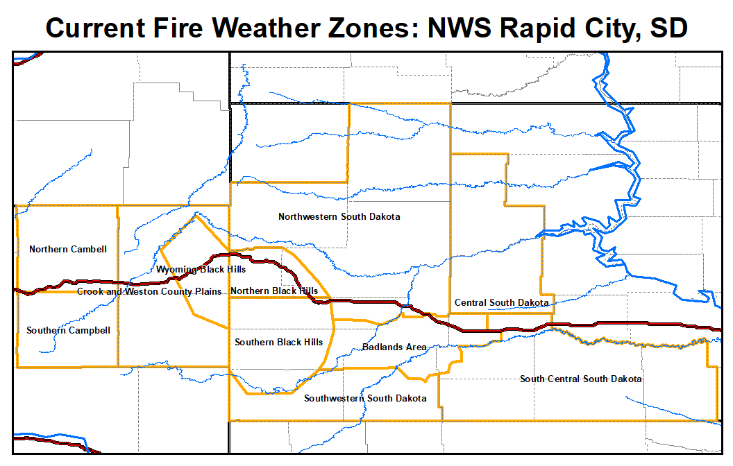
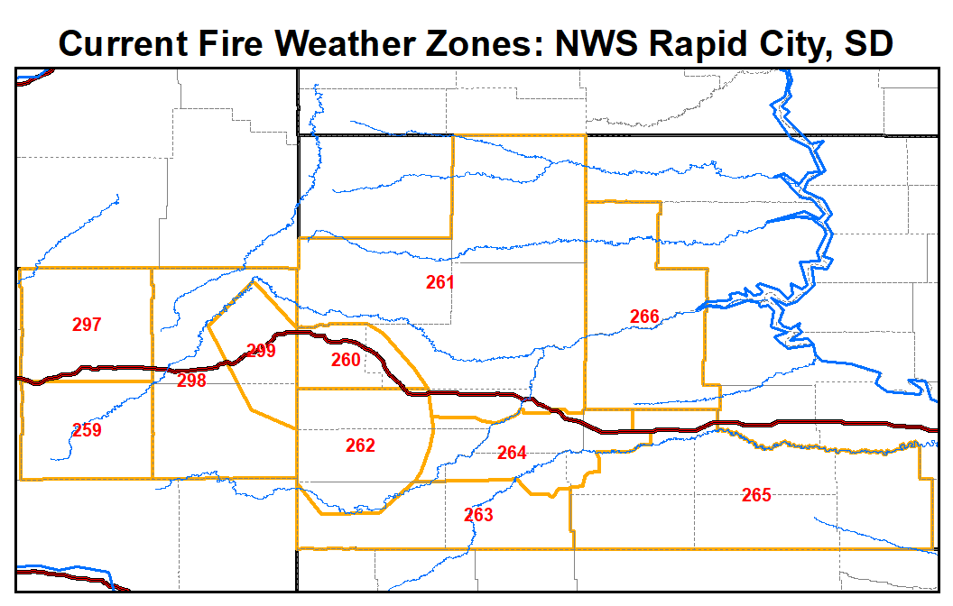
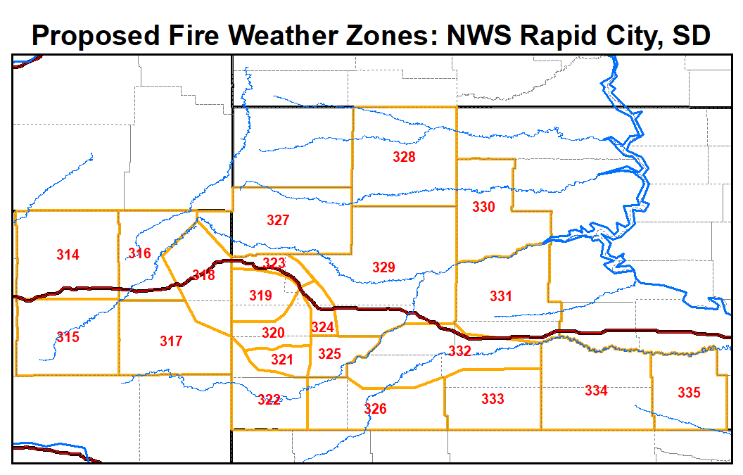
It is important to note that new zone numbers are required with this change. The current fire weather forecast zone numbers in northeastern Wyoming are WYZ259, WYZ297, WYZ298, and WYZ299. The current zone numbers in western South Dakota are SDZ260, SDZ261, SDZ262, SDZ263, SDZ264, SDZ265, and SDZ266. The new fire weather forecast zone numbers in northeastern Wyoming are WYZ314, WYZ315, WYZ316, WYZ317, and WYZ318. The new fire weather zone forecast numbers in western SD are SDZ319, SDZ320, SDZ321, SDZ322, SDZ323, SDZ324, SDZ325, SDZ326, SDZ327 (also covers part of far northeastern WY), SDZ328, SDZ329, SDZ330, SDZ331, SDZ332, SDZ333, SDZ334, and SDZ335. More specific details about these zones are described below.
Maps
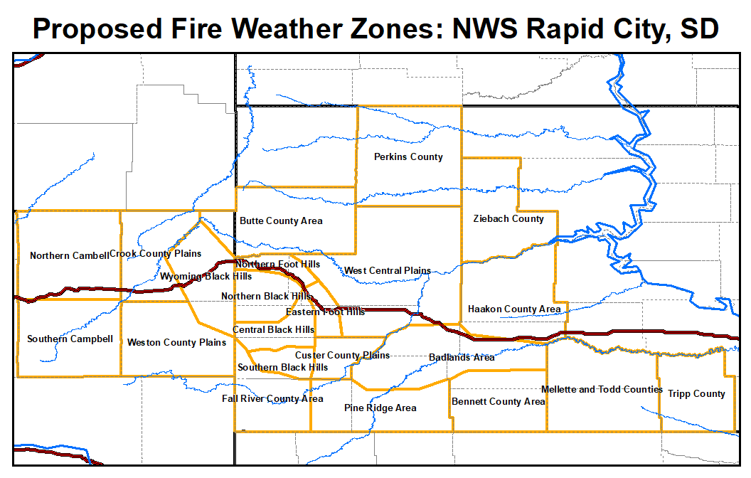
| Fire Weather Zones by Name (click to open image in new window) |
Fire Weather Zones by Number (click to open image in new window) |
 |
 |
 |
 |
Text Products
NWS watch, warning and forecast products affected by these changes are:
| WFO Rapid City Products |
WMO Heading |
AWIPS ID |
| Fire Weather Watch |
WWUS83 KUNR |
RFWUNR |
| Red Flag Warning |
WWUS83 KUNR |
RFWUNR |
| Fire Weather Planning Forecast |
FNUS53 KUNR |
FWFUNR |
NWS partners and users will need to make necessary changes to their communications systems to accommodate these fire weather forecast zone changes.
A shapefile of the new fire weather forecast zones for WFO UNR is online at: http://www.nws.noaa.gov/geodata/catalog/wsom/html/firezone.htm
Specific Fire Weather Zone Details:
- WYZ314 (Northern Campbell) and WYZ315 (Southern Campbell) remain the same but have new zone numbers (formerly WYZ297 and WYZ259).
- WYZ316 (Crook County Plains) and WYZ317 (Weston County Plains) are split in half at the Crook and Weston County line (formerly WYZ298). The climatology suggests that there are significant differences in relative humidity and wind speeds between these two new zones. Also, the far northeastern part of Crook County is split off from the Crook County Plains (see SDZ327 below for details).
- WYZ318 (Wyoming Black Hills) remains the same but has a new zone number (formerly WYZ299).
- SDZ319 (Northern Black Hills) excludes the northern foothills (formerly part of SDZ260) and includes parts of former SDZ262 (Southern Black Hills). This change is driven by the precipitation climatology to focus on the area that receives the greatest rainfall.
- SDZ320 (Central Black Hills) excludes the eastern foothills and Southern Black Hills (both formerly part of SDZ262). This change is driven by the temperature and precipitation climatology, which differs from both the northern and southern Black Hills, as well as the eastern foothills.
- SDZ321 (Southern Black Hills) excludes the central Black Hills and southern/eastern foothills (formerly part of SDZ262). This change is driven by the temperature and precipitation climatology, which differs from the rest of the Black Hills and surrounding foothills.
- SDZ322 (Fall River County Area) excludes the Southern Black Hills and the plains of eastern Fall River and southern Oglala Lakota Counties (formerly part of zones SDZ262 and SDZ263). This change is driven by the warmer and drier climatology of the far southwestern South Dakota plains.
- SDZ323 (Northern Foot Hills) is a subset of the Northern Black Hills (formerly SDZ260). The temperature and precipitation in this zone are notably different from the Northern Black Hills.
- SDZ324 (Eastern Foot Hills) is a subset of the Northern and Southern Black Hills (formerly in zones SDZ260 and SDZ262). The temperature and precipitation are notably different in this zone from the Northern and Southern Black Hills.
- SDZ325 (Custer County Plains) is a subset of the Southern Black Hills and Badlands Area (formerly in zones SDZ262 and SDZ264). The Custer County Plains have a notably different temperature, wind, and precipitation pattern than these former two zones.
- SDZ326 (Pine Ridge Area) is a subset of the Southwestern South Dakota zone (formerly SDZ263). The elevated/forested area of the Pine Ridge results in a different wind flow, temperature and precipitation pattern when compared to the far southwestern part of South Dakota.
- SDZ327 (Butte County Area) is a subset of the large Northwestern South Dakota zone (formerly SDZ261) and also includes far northeastern Wyoming, including Colony (formerly part of WYZ298). This change is a result of the temperature, precipitation and wind climatology for the area, which is notably different from places to the east.
- SDZ328 (Perkins County) is a subset of the large Northwestern South Dakota zone (formerly SDZ261). This change is a result of the temperature, precipitation and wind climatology for the area, which is notably different from places to the south and west.
- SDZ329 (West Central Plains) is a subset of the large Northwestern South Dakota zone (formerly SDZ261). This change is a result of the temperature, precipitation, and wind climatology for the area, which is notably different from places to the northwest and north.
- SDZ330 (Ziebach County) is a subset of the Central South Dakota zone (formerly SDZ266). This change is related to the downslope and upslope flow differences to the north and south of the Cheyenne River.
- SDZ331 (Haakon County Area) is a subset of the Central South Dakota, Badlands Area, and South Central South Dakota zones (formerly SDZ266, SDZ264, and SDZ265, respectively). There are notable differences in the climatology between this new zone and the former zones.
- SDZ332 (Badlands Area) closely resembles the previous Badlands Area (formerly SDZ264) but has been refined to better represent the actual Badlands boundary as well as the terrain.
- SDZ333 (Bennett County Area) is a subset of South Central South Dakota (formerly SDZ265). The temperature and precipitation climatology supports a break in this zone.
- SDZ334 (Mellette and Todd Counties) is a subset of South Central South Dakota (formerly SDZ265). The temperature and precipitation climatology supports a break in this zone.
- SDZ335 (Tripp County) is a subset of South Central South Dakota (formerly SDZ265). The temperature and precipitation climatology supports a break in this zone, especially is it becomes notably more moist toward the east.
For more information, please contact:
Jeffrey Johnson – Fire Weather Program Leader
300 East Signal Dr
Rapid City, SD 57701
605-341-9271
Jeffrey.Johnson@noaa.gov
National Service Change Notices are online at: http://www.weather.gov/os/notif.htm


 Follow us on YouTube