Summary
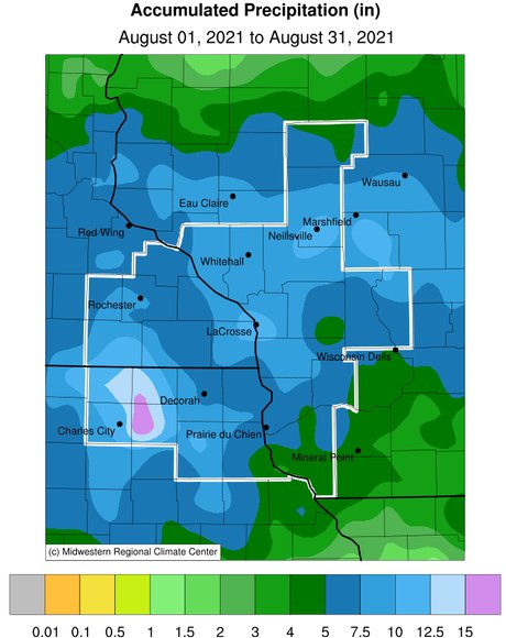
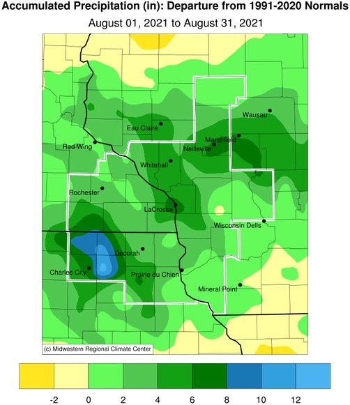
During August 2021, rainfall was highly variable across the region ranging from as little as 2.93" at Boscobel, WI to as high as 20.65" near Ionia, IA. Rainfall anomalies varied from near-normal to over a foot wetter-than-normal. August rainfall typically averages anywhere from 3.75" to 5".
New Hampton, IA received 18.60" of rain. This made it their wettest August (previous record 14.97" in 1993) and their wettest month (the previous record was 17.75" in July 1999). Fayette, IA had 11.52" of rain. This made it their wettest August (previous record 11.50" in 1979) and this month was their 6th wettest month. This was their wettest month since July 2017 (12.78" - 2nd wettest month). Their wettest month occurred in May 1902 when 15.59" of rain fell.
Flood Conditions
During August 2021, 9 Flash Flood Warnings were issued in the La Crosse Hydrologic Service Area (HSA). This was the most in a month since September 2019 (13 Flash Flood Warnings).
On August 7-8, 3" to nearly 7.5" of rain fell across parts of Houston and Winona counties in southeast Minnesota, and Crawford, La Crosse, Jackson, Monroe, southern Trempealeau, and Vernon counties in west-central and southwest Wisconsin. On August 7, La Crosse Regional Airport received 5.59" of rain. This was the most ever recorded on an August day (the previous record was 4.05" on August 18, 2007) and on a calendar day (the previous record was 5.55" on September 6, 1884). This rain prompted 2 Flash Flood Warnings. These covered La Crosse, Monroe, and Vernon counties in west-central and southwest Wisconsin. Mudslides and boulders were reported on state highways 14, 33, and 61 in La Crosse County and state highway 27 and County Rd X near Melvina in Monroe County. Several other roads in these counties and downtown La Crosse and Onalaska were flooded. The La Crosse River at La Crosse peaked at 9.5 feet on the morning of August 8. This was the 6th highest crest and the highest since March 16, 2019 (3rd highest crest). This flooded and washed out many of the trails in the La Crosse Marsh. Additional river flooding was reported along the Black and Kickapoo rivers in west-central and southwest Wisconsin.
During the evening of August 8th and the early morning hours of August 9th, very heavy rain fell across Floyd and Chickasaw counties in northeast Iowa. Rainfall totals ranged from 4" to just over 11". The highest total was 11.25" at the cooperative station near Ionia (Ionia 2W) in Chickasaw County. This was the 8th highest 24-hour rainfall in the state of Iowa and the highest since 12.34" fell at Rathbun Dam on August 24, 2007. Iowa's highest 24-hour rainfall is 13.18" near Atlantic (1 mile NE Atlantic) on June 14, 1998. This rain prompted a Flash Flood Warning for these counties. Several roads were flooded (some impassable) in Charles City and street flooding was reported in New Hampton.
On August 27-28, 3" to nearly 13" of rain fell across parts of north-central and northeast Iowa. This rain-affected northern half of Chickasaw, northern Fayette, extreme northern Floyd, Howard, Mitchell, southern Winneshiek counties in the La Crosse Hydrologic Service Area (HSA), and Worth County in the Des Moines Hydrologic Service Area (HSA). The highest rainfall total was 12.66" by the Elma cooperative observer in Howard County. This rain prompted 5 Flash Flood Warnings. Many roads were closed due to flooding. In addition, river flooding was reported along the Cedar, Turkey, Upper Iowa, and Volga rivers and their tributaries. Elkader, IA on the Turkey River had their 4th highest crests. Twenty-five other river data points in northeast Iowa also climbed above their estimated flood stage.
3" to 5" of rain fell across Vernon County in southwest Wisconsin. This prompted a Flash Flood Warning. This flash flooding caused road damage and several mudslides in the western portions of the county and flooding along the Kickapoo rivers.
2" to 3" fell across Clark County. This rain fell in the headwaters of the Black River and as this flood wave moved downstream both Galesville and Black River Falls saw their 5th highest crests.
Flooding continued into early September along the Black River at Galesville, WI, and the Yellow River at Necedah, WI.
River Conditions
The USGS average monthly streamflow for August ranged from normal to much above normal in northeast Iowa, normal to above normal in southeast Minnesota, and near (Grant County and along the Mississippi River) to high (Galesville, Neillsville, and Muscoda) from southwest into central Wisconsin. The average flows reported along the Mississippi River during the month were due to the severe (D2) to extreme (D3) drought in the headwaters of the Mississippi River and the moderate (D1) drought along the Minnesota River.
Drought
August 2021 began with drought (moderate to extreme) covering nearly half (46.4%) of the La Crosse Hydrologic Service Area (HSA). By the end of the month, the above-normal rain had reduced the moderate to severe drought to less than a tenth of the area (8.4%) and another 30.2% was abnormally dry. The only counties still experiencing drought at the end of August were Chickasaw, Clayton, Fayette, Floyd, and Mitchell counties in northeast Iowa and southern Grant County in southwest Wisconsin. Abnormally dry conditions still covered parts of southeast Minnesota, northeast Iowa, and southwest Wisconsin.
 |
 |


 Follow us on YouTube