An abrupt warmup on the 2nd to the 4th melted much of the snow cover across the central and south parts of the HSA. This resulted in moderate to strong within bank rises and localized minor flooding on tributary rivers in the central and south parts of the HSA. Much of the minor flooding was related to the increased flows and break-up ice jamming. February 2019 in the La Crosse HSA saw much above normal to record precipitation, much above normal to record snowfall and much below normal temperatures.
Precipitation for February 2019 was much above normal across the entire HSA, with record precipitation across the northern portions. Light snow and flurries fell across mainly the northwest half of the HSA on the 2nd, with widespread light rain on the 4th. Light to moderate sleet and snow fell across the HSA on the 5th. A series of lows brought light to moderate snow to most of the HSA on the 6th and 7th. Another low brought moderate to heavy snow to much of the HSA on the 10th to the 12th. Light snow fell across mainly the north half of the HSA on the 14th. Light to locally heavy snow fell across the central and south parts of the HSA on the 17th. Moderate to locally heavy snow fell across much of the HSA on the 20th. A strong low brought heavy snow to the northwest half of the HSA and moderate rain or a wintry mix to the southeast half on the 23rd into the 24th. One last storm system brought light to moderate snow to the north half of the HSA on the 26th into the 27th.
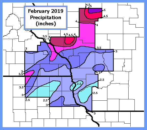
Normal precipitation for February ranges from 0.75 inch over the northwest end of the HSA to 1.25 inches across the southeast end. Totals this month ranged from 200 to 300 percent of normal across the southeast third of the HSA to 300 to 500 percent of normal across the northwest half. Most February totals were 250 to 400 percent of normal. Extreme totals recorded for the month ranged from 1.95 inches at Charles City in Floyd Co. IA and 2.23 inches at Lancaster in Grant Co. WI, to 4.81 inches at Osseo in northern Trempealeau Co. WI and 5.88 inches at Rib Lake in Taylor Co. WI.
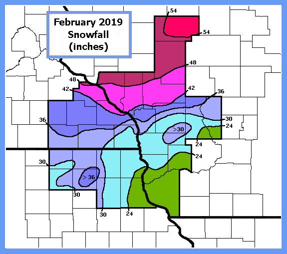
Snowfall this month ranged from 18 to 24 inches across the southeast end of the HSA, to more than 50 inches across the north end. This was 250 to as much as 700 percent of normal. Normal February snowfall ranges from 7.5 inches across the southwest end of the HSA to 9.5 inches over the east end. The snow fell from numerous events throughout the month. Snow totals this month were as much or more than normal seasonal totals across the northern portions of the HSA.
February 2019 temperatures averaged 12 to 20 degrees. This was 5 to 9 degrees below the normals. Temperatures were much below normal on the 1st, much above and above normal on the 2nd to 4th then near to below normal on the 5th and 6th. For the rest of the month, below to much below normal temperatures occurred from the 7th through 9th, 13th to the 19th, the 21st and 22nd and 24th to the 28th. The remaining intervals of the 10th to 12th, 20th, and 23rd saw near to above normal temperatures. Extremes for the month ranged from lows of 10 to 25 below on the morning of the 9th, to highs in the upper 30s to mid 40s on the 4th.
Flows in the rivers and streams of the HSA remained above normal to much above normal during February. The much below normal temperature during most of the month increased ice cover on the lakes, rivers and streams of the HSA to above normal. Snow depths were much above normal across the entire HSA most of the month. Even with the much below normal temperatures during February, ground frost depths changed very little during the month due to the deep snow cover.


 Follow us on YouTube