

Found 1 for date range "2022-12-05 to 2022-12-06". Clear Search

Mainely Weather
Welcome to NWS Caribou's Internet newsletter! Here you will find articles on weather topics relevant to Northern Maine. This might include interesting weather phenomena, event reviews, or other weather or hydrology related topics that suit our fancy! If you have an idea for a topic you'd like to see featured, please send an email to Mark.Bloomer@noaa.gov.
Current Newsletter
Common Maine Weather Hazards by Season
Mark Bloomer
The mission of the National Weather Service is to help protect life and property by delivering weather forecasts including warnings and alerts that inform the public of potentially hazardous weather so they can prepare and stay safe. Many of our weather hazards can be tied to a season when they are most common. The following is a season by season breakdown of common weather hazards here in Maine and the products we issue to alert the public.
Late summer into early fall is hurricane season. Most hurricanes that approach the north are usually whisked out to sea by the mid-latitude westerly winds. However, on occasion a strong subtropical high pressure system combined with an approaching frontal system will lift a hurricane north into Maine. The greatest impacts from a hurricane may be high winds, a storm surge along a coast, and flooding rain. The best chance for high impacts is near the coast but if a hurricane or tropical storm combines with a mid-latitude frontal system, the impacts could reach far inland. Hurricane and tropical storm watches and warnings are issued for an approaching tropical system. These include expected impacts which are usually highest along the coast.
Mid to late fall brings an increasing risk for strong St. Lawrence lows. Deep low pressure systems that track out of the Great Lakes and up through the St. Lawrence Valley can bring strong gusty south to southwesterly winds as they pull an occluded front across the area. Wind advisories and high wind warnings may be issued for these storms.
Late fall through winter brings our winter storm systems. Snow and slippery roads can result in travel hazards any time through this season. However, there are some details to winter weather hazards that are particularly dangerous and can catch people off guard. Early snows that melt from beneath can produce icy flash freezes as cold air surges in behind a winter storm. Later in winter the risk of blowing snow increases which can create white-out conditions, especially in open areas. Occasionally a warm weather system will come and bring rain in the winter. The rainfall combined with snow melt can leave dangerous icy patches as colder air returns. Fresh snowfall on top of these icy patches can both hide them and make them even more slippery creating a serious hazard. Snow squalls are another winter hazard. Snow squalls are sudden heavy snow showers accompanied by gusty winds. A quick and dangerous drop in visibility combined with roads quickly becoming very slippery make snow squalls particularly dangerous. Snow squall warnings may be issued when a snow squall approaches.
Late winter brings a continued chance for winter storms. Melting and refreezing become more common increasing a risk for changeable icy surfaces. Blowing snow in the late winter can melt on roadways under the higher sun angle and then re-freeze in the cold wind producing icy patches, especially in open areas and bends in the road. Snow piles are high which can limit visibility at intersections.
Early spring can still bring a chance of winter storms, especially over the north. However, the main weather hazard in early spring is flooding and ice jams from snow melt. Flood watches and localized flood warnings may be issued. The risk of flooding is greatest if significant rain occurs at the same time the bulk of the snow is melting, typically from late March through the first half of April.
Late spring into summer brings the chances for thunderstorms along with the gusty winds and hail these storms can bring. A severe thunderstorm watch may be issued when the chances for severe weather exists, and severe thunderstorm warnings will be issued for individual storms. Large and slow moving thunderstorms, or a series of storms tracking over the same area, can produce a risk for flash flooding. Flash flood warnings and flood advisories can be issued for localized flooding.
Maine’s Many Seasons
Mark Bloomer
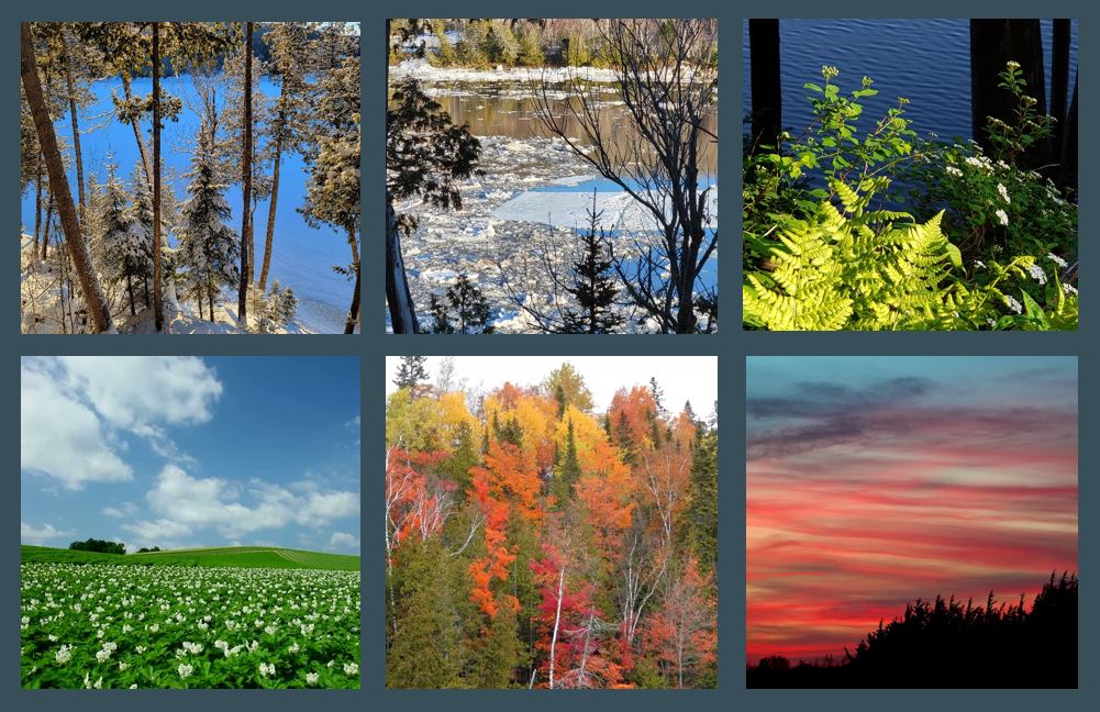
From the frozen hinterlands of mid-winter with all its snow and frigid nights to the balmy humid days of mid-summer with its lush growth and buzzing insects, Maine really has more than just one season of transition on either side of these two extremes. Early and late spring are really as distinct from one another as early and late fall. With all the changes involved, it would be fair to say Maine has at least six distinct seasons with two in the warming transition and two in the cooling transition.
Following winters deep freeze, early spring is a season of gradual thawing, mud, slush and rumbling river ice. A balmy day of sunshine and tranquility can easily be followed by a blustery day of wind and ice. The transition to warmer seasons has begun but winters stormy chill can still hang on. Early spring typically begins in late February or early March when days are getting noticeably brighter and the extreme cold begins to ease. The rate of melting increases through early spring reaching a crescendo as the rivers roar to life with rising water and rumbling ice. The breakup and clearing of river ice marks a profound transition from the moody, slushy and often icy early spring to the ice free and mostly snow free second half of spring leading into green-up.
From late April through May is the late spring green-up season. Lawns turn green by the end of April and the trees come to life with new foliage in May. Everything from dandelions to forget-me-nots are beginning to bloom. The rivers that were roaring with snow melt and crumbling ice in early spring are settling down to offer their harvest of fishes and fiddle heads.
The next noticeable transition comes in early June. The first week in June typically brings a spike in humidity as the air becomes filled with the scent of nectar and the buzzing of insects. This brings us into the lush days of summer which last from early June through most of August. This is the warmest time of year filled with new life, a burgeoning crop and very warm days along with balmy nights.
A new transition begins in late August. During this time of year many plants and grasses start going to seed and a tinge of crimson and gold can be seen in some foliage. The early fall, or what I like to call “golden fall”, lasts from late August into early October when the air is cooling but is still comfortably mild. This season crescendos with the colorful display of fall foliage.
Following “golden fall” comes the transition into “grey fall”. Like a colorful evening sunset giving way to the deeper darker violets of dusk, late fall, or “grey fall” as I like to call it, typically sets in during the second half of October and lasts through most of November. The leaves are down and a somber chill is settling over the landscape. The land has a frosty and foreboding silence as the grey and darker skies seem to portend the winter weather ahead.
Winter usually returns in late in November as winter storms begin to dress the landscape in a new blanket of snow and the long, cold dark nights refreeze the rivers and lakes. Winter lasts into late February before the first hints of early spring appear in the higher sun angles and lengthening daylight along with the first sounds of dripping snowmelt.
Past Newsletters
Found 1 for date range "2022-12-05 to 2022-12-06". Clear Search
Search
<
December 2022
>
Sun
Mon
Tue
Wed
Thu
Fri
Sat
27
28
29
30
1
2
3
4
6
7
8
9
10
11
12
13
14
15
16
17
18
19
20
21
22
23
24
25
26
27
28
29
30
31
Fall 2022 Climate Summary for Northern and Eastern Maine
Published 2022-12-05
 Coastal Flood
 Follow us on YouTube