On Thursday afternoon, August 25th 2011, portions of the Coastal Bend of South Texas experienced strong to severe thunderstorms. Several clusters of thunderstorms moved southwest across the Coastal bend and produced winds between 40 and 70 mph. Isolated pockets of wind damage were the result. There was also a brief EF-0 tornado which touched down near Alamo Beach.
An upper level disturbance originating from Northeast Texas and Arkansas the day before had pushed into Southeast Texas by the morning of the 25th. This disturbance then moved southwestward into South Texas during the afternoon of the 25th. Meanwhile, the atmosphere across South Texas became increasingly moist and unstable throughout the afternoon as this disturbance moved into the area.
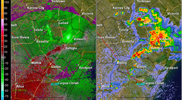
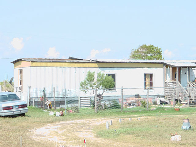
By 115 PM CDT, the first wave of thunderstorms begain moving into Victoria and Calhoun Counties from the northeast. Reports of winds up to 63 mph along with wind damage were reported shortly thereafter in Victoria county. As two boundaries collided in northern Calhoun county, a weak tornado developed in Alamo Beach. The tornado had winds up to 75 mph which damaged four homes. No injuries were reported with the tornado. The tornado had a path length of 1/4 mile and a path width of 100 yards. More information on the tornado can be found in a Public Information Statement.
Several intensifying clusters of thunderstorms then moved southwest into Refugio County by 230 PM CDT and into San Patricio County by 320 PM CDT. Although little damage was reported in these counties, the potential for severe straight-line winds was observed on Doppler radar from just to the north of Refugio to east of Sinton and then to Nueces Bay. A 67 mph wind gust at 250 feet was recorded on a wind turbine in San Patricio County as the storms pushed southward. A line of severe thunderstorms moved south into Nueces County by 4 PM CDT. A 59 mph wind gust was recorded at the Corpus Christi International Airport along an outflow boundary which was located just ahead of the actual rain and thunderstorms. Although no hail was reported during this event, large hail may have been present aloft as this hail spike indicates. The storms began to slowly weaken after 500 PM CDT as daytime heating began to wane.
Damage was fairly minimal throughout the region, although 3,000 customers did lose power during the storms. The storms did bring beneficial rainfall to most of drought-stricken South Texas.

| Alamo Beach |
..TIME...   ...EVENT...      ...CITY LOCATION...     ...LAT.LON...
..DATE...   ....MAG....      ..COUNTY LOCATION..ST.. ...SOURCE....
            ..REMARKS..

0125 PM     TORNADO          4 SE PORT LAVACA        28.57N 96.57W
08/25/2011  F0               CALHOUN            TX   NWS STORM SURVEY

            AN NWS SURVEY CONCLUDED A SHORT LIVED TORNADO TOUCHED
            DOWN IN ALAMO BEACH. MAXIMIMUM WINDS OF 75 MPH WERE
            ESTIMATED ALONG WITH A PATH LENTH OF 1/4 MILE AND PATH
            WIDTH OF 100 YARDS. THREE HOMES WERE OBSERVED TO HAVE
            MINOR ROOF AND SHINGLE DAMAGE. A FOURTH AND POORLY
            CONSTRUCTED TWO STORY MOBILE HOME SUSTAINED SIGNIFICANT
            DAMAGE...WITH THE TOP STORY TAKEN OFF. NO INURIES
            OCCURRED WITH THIS TORNADO. FOR ADDITIONAL INFORMATION
            PLEASE SEE THE PUBLIC INFORMATION STATEMENT ISSUED FOR
            THIS EVENT.

0130 PM     TSTM WND DMG     VICTORIA                28.82N 96.98W
08/25/2011                   VICTORIA           TX   TRAINED SPOTTER

            ROOF DAMAGE...SEVERAL TREES DOWN AND SMALL TRAVEL CAMPER
            BLOWN OVER...2500 BLOCK OF LONE TREE STREET

0140 PM     TSTM WND DMG     3 N VICTORIA            28.87N 96.98W
08/25/2011                   VICTORIA           TX   LAW ENFORCEMENT

            TELEPHONE WIRES KNOCKED DOWN IN VICTORIA AT THE 1100
            BLOCK OF SALEM ROAD AND 1000 BLOCK OF VIRGINIA

0147 PM     TSTM WND GST     INEZ                    28.88N 96.78W
08/25/2011  M63.00 MPH       VICTORIA           TX   TRAINED SPOTTER

            MEASURED THUNDERSTORM WIND GUST OF 63 MPH REPORTED IN
            INEZ,TX

0200 PM     TSTM WND DMG     SW VICTORIA             28.82N 96.98W
08/25/2011                   VICTORIA           TX   PUBLIC

            PINE TREE 8 TO 10 INCHES IN DIAMETER DOWNED. TIME IS
            APPROX.

0200 PM     LIGHTNING        VICTORIA                28.82N 96.98W
08/25/2011                   VICTORIA           TX   COUNTY OFFICIAL

            TWO SEPARATE HOUSE FIRES IN VICTORIA CAUSED BY LIGHTNING
            WITH STRUCTURAL DAMAGE AND ELECTRICAL PANELS BLOWN OUT.
            REPORTED BY RED CROSS.

0315 PM     TSTM WND DMG     6 ESE BEEVILLE          28.37N 97.66W
08/25/2011                   BEE                TX   TRAINED SPOTTER

            TREES DOWN NEAR CHASE FIELD. TIME IS APPROX.

0320 PM     TSTM WND DMG     BEEVILLE                28.41N 97.75W
08/25/2011                   BEE                TX   TRAINED SPOTTER

            POWERLINES AND WIRES BLOWN DOWN INTO TREES IN ALMOST
            MIDDLE OF TOWN. TIME IS APPROX.

0330 PM     TSTM WND DMG     3 NW TAFT               28.01N 97.43W
08/25/2011                   SAN PATRICIO       TX   PUBLIC

            POWERPOLE BLOWN DOWN ON RAILROAD TRACK.

0357 PM     TSTM WND GST     1 W CORPUS CHRISTI      27.77N 97.52W
08/25/2011  M59.00 MPH       NUECES             TX   ASOS

            59 MPH GUST RECORDED AT CORPUS CHRISTI ASOS. CORRECETED
            FOR LAT/LONG.

0358 PM     WATER SPOUT      5 N CORPUS CHRISTI      27.78N 97.29W
08/25/2011                   GMZ230             TX   TRAINED SPOTTER

            BRIEF WATERSPOUT REPORTED ON CORPUS CHRISTI BAY. REPORT
            STATED IT HAD LIFTED.

0406 PM     MARINE TSTM WIND 4 NNE CORPUS CHRISTI    27.83N 97.49W
08/25/2011  M44.00 MPH       GMZ230             TX   MESONET

            NUECES BAY TCOON STATION REPORTED GUST TO 38 KTS...44
            MPH.


 Follow us on YouTube