
A potent upper level storm system moved across South Texas early Sunday morning, January 9, 2011, producing strong damaging winds, large hail, and at least one long track tornado. Widespread wind damage was observed across the Coastal Bend as the storms moved quickly through the region. Approximately 30,000 customers lost power as a result of the storms. This marks the first time a tornado has been recorded in South Texas in the month of January, dating back to 1950.
A cold front moved through South Texas on Saturday morning, January 8, 2011 and was situated over Deep South Texas Saturday afternoon, with temperatures generally in the 50s area-wide. However as the storm system approached, a surface low pressure area formed along the frontal boundary, which helped to draw warm and humid conditions northward into the Coastal Bend. As the upper level storm system moved through the region, very strong wind shear developed and combined with an unstable atmosphere to produce a line of severe thunderstorms. A tornadic thunderstorm developed near the proximity of the surface low and retreating warm front, which persisted for over 20 miles travelling from just southeast of Alice to near Calallen. Damaging straight line winds affected most of the Coastal Bend and extended well into the Gulf of Mexico east of Rockport.
The line of thunderstorms first moved through the Cotulla and Laredo areas around 115 AM CST, producing heavy rainfall, and wind gusts to 35 to 40 mph. The line of storms strengthened between 200 and 300 AM CST as it moved east into McMullen, Duval, and Live Oak Counties, producing wind gusts between 40 and 50 mph.
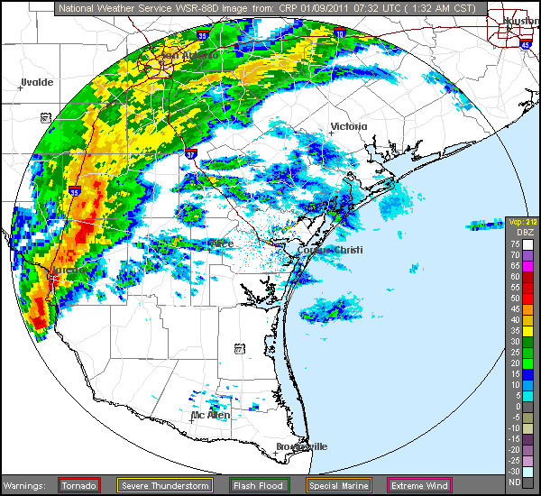
The southern end of the line of thunderstorms became severe as it moved through central Jim Wells County between 315 and 330 AM CST. Radar indicated a bowing to the line of storms near Alice, an indication of severe winds. A wind gust to 67 mph occurred at the Alice International Airport. Just Southeast of Alice, Doppler radar indicated a tornado forming around 325 AM CST. From this point in Jim Wells county through northwest Nueces and southern San Patricio Counties, doppler radar continued to show very strong signs of rotation. This rotation can be easily seen in this image.
A National Weather Service (NWS) storm survey team determined a tornado touched down roughly 4 miles southeast of Alice International Airport and continued northeast for 20.5 miles, traveling through the northwest side of Robstown and ending near Five Points in Calallen. Along this track, the tornado was strongest from the west-southwest side of Robstown to its end point near Calallen, where wind speeds of up to 100 mph (an EF-1 Tornado) and a width of 150-200 yards were estimated. Damage to high voltage power lines, poles, large trees, and signs were observed along the path length. In addition, two large sheds, a barn and a tractor were destroyed southwest of Robstown. On the northwest side of Robstown, numerous trees were snapped and several homes had damage to shingles and wooden roofing. Debris in the form of tin, wood, and sports equipment were strewn across Robstown High School. This was the first tornado on record in South Texas during the month of January.
Just southeast of the tornado, in the rear flank downdraft of the storm, straight-line winds of 69 mph were recorded at the Corpus Christi International Airport along with marble (1/2") sized hail.
From Calallen through Portland and Rockport, doppler radar indicated a broad, yet strong rotation between 4 and 430 AM CST. A NWS storm survey concluded straight-line winds between 70 and 80 mph occurred along this path. Sporadic tree and power line damage was observed along this path. In addition, three mobile homes were completely destroyed in Portland, and several more damaged. A few trees were also uprooted in Rockport and one home sustained roof damage. A path length of damage of nearly 65 miles was observed from the starting point of the tornado in Jim Wells County to the end of the straight-line wind damage in Rockport.
Further north, doppler radar indicated another bowing segment in the line across southern Victoria and Calhoun Counties between 430 and 500 AM CST. The Seadrift TCOON site recorded a wind gust of 70 mph. A NWS storm survey team concluded straight line wind speeds of around 70 mph occurred from rural southeastern Victoria County to Seadrift. Telephone poles and one parking light pole were blown down. In addition, an awning was torn off and blown into boats at the marina in Seadrift.
|
Click the placemarkers for additional information. The red line depicts the tornado track while the orange line depicts the core of the strongest straight-line winds. The green marker depicts the EF-1 Tornado track while the blue marker depicts EF-0 damage. |
 |
 |
| KCRP Radar Reflectivity loop beginning at 132 AM CST on 01/09/11 and ending at 543 AM CST on 01/09/11. | KCRP Radar Reflectivy loop highlighting the thunderstorm with the strongest rotation. |

| 3-Dimensional KCRP Radar depiction of the tornado that tracked from southeast of Alice to Calallen. |
 |
 |
| Infrared Satellite loop beginning at 515 PM CST on 01/08/11 and ending at 915 AM CST on 01/09/11. | Water Vapor Satellite loop beginning at 645 PM CST on 01/08/11 and ending at 1031 AM CST on 01/09/11. |
 |
 |
| Banquete | Robstown |
 |
 |
| Portland | Rockport |
 |
 |
| Placedo | Miscellaneous Locations |

|
Peak Wind Gusts and the Tornado Track. |
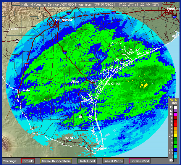
| Storm Total Rainfall for this event. |
..TIME...   ...EVENT...      ...CITY LOCATION...     ...LAT.LON...
..DATE...   ....MAG....      ..COUNTY LOCATION..ST.. ...SOURCE....
            ..REMARKS..

0325 AM     TORNADO          7 ESE ALICE             27.71N 97.97W
01/09/2011  F1               JIM WELLS          TX   NWS STORM SURVEY

            A NWS STORM SURVEY CONCLUDED A LONG TRACK TORNADO
            OCCURRED ACROSS JIM WELLS AND NUECES COUNTIES. THE
            TORNADO BEGAN ROUGHLY 4 MILES SOUTHEAST OF ALICE AIRPORT
            AND ENDED 2 MILES NORTH OF ROBSTOWN. SPORADIC EF-0 DAMAGE
            WAS OBSERVED FROM THE START POINT TO ROUGHLY 8 MILES
            WEST-SOUTHWEST OF ROBSTOWN. EF-1 DAMAGE WITH WINDS
            ESTIMATED AT 100 MPH WAS OBSERVED FROM WEST-SOUTHWEST OF
            ROBSTOWN TO THE END POINT. THE TORNADO HAD A PATH LENGTH
            OF ALMOST 21 MILES AND A MAXIMUM PATH WIDTH OF 150-200
            YARDS.

0330 AM     TSTM WND GST     ALICE                   27.76N 98.07W
01/09/2011  M67.00 MPH       JIM WELLS          TX   ASOS

0345 AM     TSTM WND DMG     1 W ROBSTOWN            27.80N 97.68W
01/09/2011                   NUECES             TX   NWS STORM SURVEY

            WEST SIDE OF ROBSTOWN...TREES AND POWERLINES DOWN. SHEET
            METAL WRAPPED AROUND POWER POLES. SHINGLE AND WOODEN ROOF
            DAMAGE TO HOMES. ROOF TORN OFF ROBSTOWN HIGH SCHOOL GYM
            AND AIR CONDOTIONING UNITS DAMAGED. DAMAGE RESULT OF
            TORNADO.

0345 AM     TSTM WND DMG     2 W ROBSTOWN            27.80N 97.69W
01/09/2011                   NUECES             TX   NWS EMPLOYEE

            NWS EMPLOYEE REPORTED TREES AND POWERLINES DOWN ON THE
            WEST SIDE OF ROBSTOWN. SHEET METAL WAS WRAPPED AROUND
            POWER POLES.

0350 AM     TSTM WND DMG     13 WNW CORPUS CHRISTI   27.78N 97.49W
01/09/2011                   NUECES             TX   NWS EMPLOYEE

            SEMI TRUCK FLIPPED NEAR THE 5 POINTS WALMART IN CALALLEN.
            STREET SIGNS DOWN. SHOPPING CARTS BLOWN ONTO HIGHWAY.

0353 AM     TSTM WND GST     DRISCOLL                27.67N 97.75W
01/09/2011  E60.00 MPH       NUECES             TX   TRAINED SPOTTER

            TRAINED SPOTTER REPORTED EST 60 MPH WINDS

0353 AM     HAIL             DRISCOLL                27.67N 97.75W
01/09/2011  E1.00 INCH       NUECES             TX   TRAINED SPOTTER

            QUARTER SIZED HAIL WITHIN DRISCOLL. POWER OUTAGES ALSO
            BEING REPORTED.

0354 AM     MARINE TSTM WIND 7 N CORPUS CHRISTI      27.81N 97.29W
01/09/2011  M50.00 MPH       GMZ230             TX   MESONET

            TCOON - NUECES BAY

0380 AM     MARINE TSTM WIND 14 NW CORPUS CHRISTI    27.85N 97.45W
01/09/2011  M53.00 MPH       GMZ230             TX   MESONET

            TCOON - NUECES DELTA

0402 AM     HAIL             CORPUS CHRISTI          27.71N 97.29W
01/09/2011  E0.50 INCH       NUECES             TX   NWS EMPLOYEE

            MARBLE SIZED HAIL AT THE CORPUS CHRISTI AIRPORT.

0402 AM     TSTM WND GST     CORPUS CHRISTI          27.71N 97.29W
01/09/2011  M69.00 MPH       NUECES             TX   ASOS

            ASOS AT CORPUS CHRISTI AIRPORT REPORTING 69 MPH WINDS.

0405 AM     TSTM WND GST     CORPUS CHRISTI          27.71N 97.29W
01/09/2011  M45.00 MPH       NUECES             TX   ASOS

            CABANISS FIELD

0407 AM     TSTM WND GST     KINGSVILLE              27.51N 97.86W
01/09/2011  M40.00 MPH       KLEBERG            TX   ASOS

            KINGSVILLE NAS

0410 AM     TSTM WND DMG     5 NW PORTLAND           27.93N 97.38W
01/09/2011                   SAN PATRICIO       TX   PUBLIC

            NWS STORM SURVEY TEAM OBSERVED TREE...SIGN...FENCE AND
            POWER LINE DAMAGE IN AND NORTHWEST OF PORTLAND. 3 MOBILE
            HOMES COMPLETELY DESTROYED AND SEVERAL OTHER DAMAGED.
            SHINGLE DAMAGE WAS OBSERVED ON SEVERAL HOMES. A BARN WAS
            DESTOYED AS WELL. WINDS WERE ESTIMATED AT 80 MPH.

0416 AM     TSTM WND GST     CORPUS CHRISTI          27.71N 97.29W
01/09/2011  M59.00 MPH       NUECES             TX   NWS EMPLOYEE

            59 MPH WIND MEASURED IN CORPUS CHRISTI ALONG SOUTH PADRE
            ISLAND DRIVE.

0418 AM     MARINE TSTM WIND 2 E CORPUS CHRISTI      27.71N 97.26W
01/09/2011  M60.00 MPH       GMZ230             TX   MESONET

            CORPUS CHRISTI MARINA

0418 AM     MARINE TSTM WIND 1 W INGLESIDE           27.87N 97.22W
01/09/2011  M52.00 MPH       SAN PATRICIO       TX   MESONET

            TCOON

0418 AM     MARINE TSTM WIND 4 NNE ROCKPORT          28.09N 97.03W
01/09/2011  M48.00 MPH       ARANSAS            TX   MESONET

            TCOON - COPANO EAST

0419 AM     TSTM WND GST     CORPUS CHRISTI          27.71N 97.29W
01/09/2011  M45.00 MPH       NUECES             TX   ASOS

            CORPUS CHRISTI NAS

0419 AM     TSTM WND GST     CORPUS CHRISTI          27.71N 97.29W
01/09/2011  M45.00 MPH       NUECES             TX   ASOS

            WALDRON FIELD

0424 AM     HAIL             1 NW ARANSAS PASS       27.90N 97.15W
01/09/2011  E1.00 INCH       SAN PATRICIO       TX   TRAINED SPOTTER

0424 AM     MARINE TSTM WIND 1 NW PORT ARANSAS       28.49N 98.09W
01/09/2011  M58.00 MPH       LIVE OAK           TX   MESONET

            TCOON - FERRY LANDING

0430 AM     TSTM WND DMG     ROCKPORT                28.04N 97.05W
01/09/2011                   ARANSAS            TX   TRAINED SPOTTER

            ROOF DAMAGE TO ONE HOME IN ROCKPORT. A FEW TREES WERE
            UPROOTED AS WELL. WINDS ESTIMATED AT 75 MPH.

0436 AM     TSTM WND GST     ROCKPORT                28.04N 97.05W
01/09/2011  M54.00 MPH       ARANSAS            TX   ASOS

0440 AM     TSTM WND DMG     BLOOMINGTON             28.63N 96.88W
01/09/2011                   VICTORIA           TX   NEWSPAPER

            CARPORT ROOF BLOWN OFF OF A HOME. ROOF PARTIALLY CAVED IN
            AND WINDOWS BLOWN OUT OF ANOTHER HOME. A POWER POLE WAS
            ALSO BLOWN DOWN. A SHED WAS BLOWN INTO A NEABY HOUSE AND
            STREET. WINDS OF 70 MPH ESTIMATED BY STORM SURVEY TEAM.

0440 AM     TSTM WND DMG     PLACEDO                 28.67N 96.83W
01/09/2011                   VICTORIA           TX   DEPT OF HIGHWAYS

            PORTION OF ROOF BLOWN OFF HOUSE AND BARN ON HIGHWAY 87
            JUST SOUTH OF FM 616. WINDS OF 70 MPH ESTIMATED BY STORM
            SURVEY TEAM.

0440 AM     TSTM WND DMG     4 E PLACEDO             28.67N 96.77W
01/09/2011                   VICTORIA           TX   DEPT OF HIGHWAYS

            GUARDRAIL DAMAGE TO PLACEDO BRIDGE. POWER LINES DOWN IN
            THE AREA AND STREET SIGNS DOWN.

0440 AM     TSTM WND DMG     2 S VICTORIA            28.80N 96.98W
01/09/2011                   VICTORIA           TX   DEPT OF HIGHWAYS

            CAR BLOWN INTO DITCH ON HIGHWAY 87 ONE MILE NORTH OF 447.


0442 AM     MARINE TSTM WIND 1 SE ROCKPORT           28.03N 97.04W
01/09/2011  M51.00 MPH       ARANSAS            TX   MESONET

            ROCKPORT TCOON

0442 AM     MARINE TSTM WIND 1 E PORT OCONNOR        28.44N 96.38W
01/09/2011  M51.00 MPH       GMZ330             TX   MESONET

            TCOON

0445 AM     TSTM WND DMG     VICTORIA                28.82N 96.98W
01/09/2011                   VICTORIA           TX   LAW ENFORCEMENT

            POWER POLE BLOWN ONTO TRAILOR HOME AT 13000 BLOCK OF
            HIGHWAY 87 NORTH.

0448 AM     TSTM WND GST     VICTORIA                28.82N 96.98W
01/09/2011  M48.00 MPH       VICTORIA           TX   ASOS

0448 AM     MARINE TSTM WIND 2 W SEADRIFT            28.03N 98.55W
01/09/2011  M70.00 MPH       DUVAL              TX   MESONET

            TCOON

0448 AM     TSTM WND DMG     SEADRIFT                28.38N 96.69W
01/09/2011                   CALHOUN            TX   NWS STORM SURVEY

            A LARGE LIGHT POLE WAS SNAPPED AT A BASEBALL FIELD NEAR
            MAIN STREET AND HOUSTON AVENUE. AN AWNING WAS BLOWN OFF
            OF A BUSINESS AND INTO BOATS AT THE MARINA IN SEADRIFT. A
            NWS STORM SURVEY TEAM ESTIMATED WIND SPEEDS OF 70
            MPH...WHICH WAS ALSO RECORDED BY A NEARBY TCOON SITE.

0454 AM     MARINE TSTM WIND 13 SE CORPUS CHRISTI    27.57N 97.14W
01/09/2011  M51.00 MPH       GMZ250             TX   MESONET

            TCOON - SOUTH BIRD ISLAND

0454 AM     MARINE TSTM WIND 16 SE CORPUS CHRISTI    27.54N 97.11W
01/09/2011  M55.00 MPH       GMZ250             TX   MESONET

            BOB HALL PIER

0500 AM     TSTM WND DMG     PORT LAVACA             28.61N 96.62W
01/09/2011                   CALHOUN            TX   CO-OP OBSERVER

            FEW ASPHALT SHINGLES BLOWN OFF RESIDENCE.


 Follow us on YouTube