 |
| Storm Reports |
| Are you interested in what happened during a recent event? Check out the report below. |
|
|
 |
December, 2021 Storm Report |
 |
| |
| |
Temperatures |
Precipitation |
| Site |
Max |
Min |
Avg |
Norm |
Dep |
Hi |
Lo |
Sum |
Norm |
Dep |
| Fayetteville (NW AR) |
63.9 |
39.1 |
51.5 |
38.8 |
+12.7 |
77 |
21 |
5.36 |
3.07 |
+2.29 |
| Harrison (NC AR) |
63.7 |
40.3 |
52.0 |
39.7 |
+12.3 |
80 |
20 |
4.49 |
2.94 |
+1.55 |
| Jonesboro (NE AR) |
61.8 |
42.3 |
52.1 |
41.5 |
+10.6 |
76 |
26 |
2.07 |
4.45 |
-2.38 |
| Fort Smith (WC AR) |
66.1 |
42.5 |
54.3 |
42.8 |
+11.5 |
80 |
26 |
4.44 |
3.48 |
+0.96 |
| Little Rock (C AR) |
65.3 |
44.4 |
54.8 |
43.0 |
+11.8 |
78 |
27 |
4.07 |
5.08 |
-1.01 |
| Texarkana (SW AR) |
70.0 |
51.1 |
60.6 |
46.4 |
+14.2 |
82 |
31 |
3.88 |
4.68 |
-0.80 |
| El Dorado (SC AR) |
68.9 |
46.9 |
57.9 |
46.8 |
+11.1 |
82 |
28 |
1.90 |
5.61 |
-3.71 |
| Pine Bluff (SE AR) |
67.7 |
46.5 |
57.1 |
45.0 |
+12.1 |
80 |
28 |
3.11 |
5.30 |
-2.19 |
|
Temperatures were significantly above average across the state through the month of December. In fact, since records began in 1895, this was the warmest December for the state of Arkansas in terms of average temperature. Unlike temperatures, precipitation departures from average weren't uniform across the state. Generally, rainfall amounts across northern Arkansas were more than 1 to 3 inches above average. Elsewhere, from northeast to central and across southern Arkansas rainfall amounts ended up below average by as much as 4 inches near El Dorado (Union County).
|
| |
| There were numerous record high temperatures broken in December. Check out the records below. |
| Site |
Record High (Date of Occurrence) |
| Batesville |
80 (12/02), 76 (12/03), 77 (12/25) |
| Harrison |
78 (12/02), 80 (12/03), 74 (12/26) |
| Hot Springs |
78 (12/02), 72T (12/15), 75 (12/16), 79 (12/25), 75T (12/27), 79 (12/28) |
| Jacksonville |
78 (12/02), 79 (12/10), 79 (12/25) |
| Little Rock |
78T (12/10), 78 (12/25), 74 (12/28) |
| Monticello |
76 (12/02), 81 (12/10), 79 (12/29) |
| Mount Ida |
80 (12/02) |
| North Little Rock |
76 (12/10), 71 (12/16), 76 (12/25) |
| Russellville |
79 (12/10), 77 (12/15), 79 (12/25) |
| Stuttgart |
76 (12/02), 75T (12/03), 79 (12/10), 77 (12/25), 76 (12/27) |
| Note: "T" means record was tied. |
| Site |
Record Warm Low (Date of Occurrence) |
| Harrison |
65 (12/15) |
|
While December 2021 was somewhat active across the state it will be remembered for the extremely warm temperatures observed at all locations. A notable severe weather event took place from December 10-11, providing a few tornadoes to northeast Arkansas. In fact, an EF4 tornado occurred which hasn't happened in Arkansas since April 2014.
|
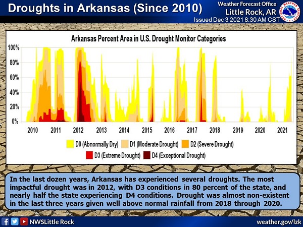 |
| In the picture: Drought conditions have been documented in Arkansas every year since records began with one of the most notable droughts of recent memory occurring in 2012. D2 conditions developed across the area in late November 2021. |
|
| |
|
Remarkably warm temperatures were observed across much of the state during the first few days of the month. Numerous sites recorded daily high temperature records from Dec 2-3. Harrison (Boone County) recorded daily highs of 78 and 80 on the 2nd and 3rd. The 80 degree reading on Dec 3 was only the third time in history that Harrison has recorded a temperature of 80 or higher in December. Records have been kept in Harrison since 1891.
Along with the abnormally warm temperatures, little rainfall was reported for the first few days of the month. After a dry November this led to an increase in wildfire danger and drought conditions across the state. The Arkansas Forestry Division increased the wildfire danger across portions of northwest Arkansas to High with much of the rest of northern and eastern Arkansas under Moderate wildfire danger. D2 drought conditions developed across southwest Arkansas.
|
|
|
| In the pictures: Both the 6-10 and 8-14 day temperature outlooks issued by the NWS Climate Prediction Center indicated high confidence in above average temperatures for mid to late December. |
|
| |
|
Above normal temperatures continued through Dec 5 before a cold front moved toward the state from the north. Storms developed across Missouri and moved south as a line of storms through Dec 6. No severe weather was reported across the state but a few locations did pick up over an inch of rain. The front brought cooler air and breezy NW winds, but the cooler air didn't last very long.
|
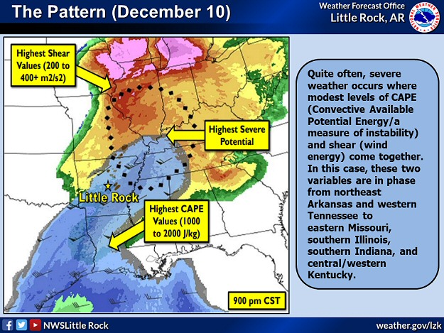 |
| In the picture: The greatest threat of severe weather could be expected where the greatest wind shear and instability intersect. |
|
| |
|
As Dec 10 approached, chances of severe weather began to increase from Arkansas northeastward across the Ohio Valley. As the day progressed, numerous thunderstorms developed and intensified from Arkansas into Missouri and points to the east. Numerous tornadoes occurred (12 in Arkansas) and sadly, two people died in Arkansas with more deaths reported elsewhere. Perhaps the only benefit from the severe weather event across the area was some beneficial rain, but rainfall coverage was not uniform and several locations missed out on rain altogether.
|
|
While cool conditions were briefly seen in the wake of the front, temperatures began to warm once again by the middle of the month. Breezy southerly winds were noted on the 15th as temperatures climbed into the 70s across much of the state. A quick moving, intense storm system moved from Colorado toward the Great Lakes. Non-thunderstorm winds across Colorado gusted above 100 mph in a few spots. Locally portions of NW Arkansas gusted to nearly 50 mph. An intense line of storms produced widespread wind damage and tornadoes from Kansas to Wisconsin. Prior to Dec 15, 2021 Minnesota had never recorded a tornado in December. 16 tornadoes occurred across Minnesota that day.
|
 |
| In the picture: Rainfall amounts varied across the state with portions of east/southeast Arkansas seeing less than one half inch. Western and northern Arkansas picked up more than a couple inches of rain. |
|
| |
|
A stalled front was in place across the area from Dec 17-18 acting as the focus for widespread rainfall. Initially the heavy rain threat was across northern Arkansas and southern Missouri but by the 18th, rain expanded south. Some flash flooding was reported across portions of southern Missouri, near Branson.
Several dry days were noted as the new year approached with temperatures warming into the 70s and even 80s at times from Dec 23-28. Several daily high temperature records were broken with quite a few locations seeing the warmest Christmas on record.
|
|
|
| In the picture: An active weather period was expected for Dec 29 and Dec 31-Jan 1. |
|
| |
|
Other than a couple large hail reports from Dec 29 across Drew and Bradley Counties, there wasn't much severe weather reported across Arkansas near the end of the year, widespread rain and thunderstorms were noted on Dec 29 and again on Dec 31. Much of the heaviest rain held off until just after the new year, but portions of western and northern Arkansas picked up some heavy rain before midnight.
|
| Temperature and Precipitation Trends |
| |
 |
| In the picture: Temperatures at Little Rock (Pulaski County). Click to enlarge. |
|
 |
| In the picture: Precipitation at Little Rock (Pulaski County). Click to enlarge. |
|
 |
| In the picture: Precipitation across Arkansas. |
|
|
|


 Follow us on YouTube