 |
| Storm Reports |
| Are you interested in what happened during a recent event? Check out the report below. |
|
|
 |
February, 2022 Storm Report |
 |
| |
| |
Temperatures |
Precipitation |
| Site |
Max |
Min |
Avg |
Norm |
Dep |
Hi |
Lo |
Sum |
Norm |
Dep |
| Fayetteville (NW AR) |
53.3 |
24.3 |
38.8 |
40.4 |
-1.6 |
73 |
4 |
4.47 |
2.56 |
+1.91 |
| Harrison (NC AR) |
51.0 |
26.3 |
38.6 |
40.9 |
-2.3 |
71 |
13 |
3.10 |
2.42 |
+0.68 |
| Jonesboro (NE AR) |
50.4 |
29.3 |
39.8 |
42.6 |
-2.8 |
69 |
20 |
3.99 |
3.79 |
+0.20 |
| Fort Smith (WC AR) |
55.5 |
28.6 |
42.1 |
45.0 |
-2.9 |
74 |
17 |
4.62 |
2.69 |
+1.93 |
| Little Rock (C AR) |
57.0 |
32.5 |
44.7 |
44.7 |
0.0 |
72 |
23 |
5.30 |
3.97 |
+1.33 |
| Texarkana (SW AR) |
60.4 |
35.9 |
48.1 |
48.1 |
0.0 |
79 |
24 |
4.49 |
4.10 |
+0.39 |
| El Dorado (SC AR) |
57.8 |
30.9 |
44.3 |
48.3 |
-4.0 |
74 |
19 |
2.74 |
4.30 |
-1.56 |
| Pine Bluff (SE AR) |
56.6 |
34.1 |
45.4 |
46.5 |
-1.1 |
75 |
22 |
3.91 |
4.27 |
-0.36 |
|
Temperatures were at or below average across the entire state with several locations more than a few degrees below average for the month. With several rounds of precipitation across the state, most locations saw above average rainfall. Some portions of southern Arkansas continued to see below average amounts.
|
| |
| Only one temperature record was broken in February. Check out the records below. |
| Site |
Record Low (Date of Occurrence) |
| Jacksonville/LR AFB |
17 (2/14) |
| Note: "T" means record was tied. |
|
February proved to be a chaotic month in terms of weather across the state with wild temperature swings and a few rounds of precipitation including snow, sleet, freezing rain and thunderstorms. Monthly average temperatures ended up at or below normal while monthly rainfall totals continued the Winter 2021-2022 trend with drier than normal conditions across the south.
|
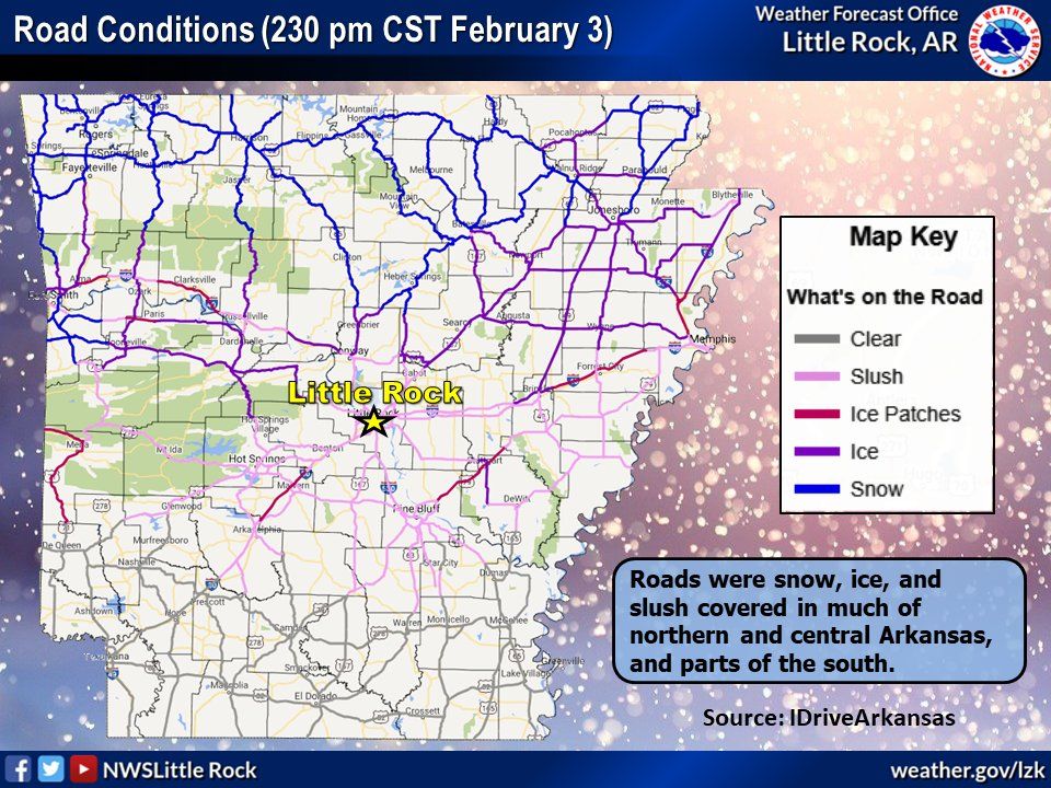 |
| In the picture: Road conditions reported from IDriveArkansas indicated snow covered roads across the north with ice and slush across portions of western, central and eastern Arkansas. |
|
| |
|
While temperatures were well above average at the start of the month, an Arctic airmass quickly moved in across the state on Feb 2nd. Through the 3rd the cold air expanded south and snow/sleet/freezing rain became widespread across all but far southern Arkansas. Heavy snow was the primary precipitation type across the north, mostly sleet across central areas and freezing rain was the most significant across the west and southeast.
As the storm system moved across the area through the morning of Feb 4th, a final round of light snow fell across the northern half of the state. A few spots picked up 1-2 inches of additional snow. The sun came out by the afternoon of Feb 4th with a slow warmup beginning. Feb 5th was cold in the morning with sunny skies and improving road conditions. Road conditions were significantly better statewide by Saturday, Feb 5th.
|
|
|
| In the picture: Snow was observed during the morning hours of February 12th in Malvern (Hot Spring County). |
|
| |
|
Dry and calm weather with warming temps was observed through Friday, Feb 11th. Temperatures warmed into the 60s/70s on Feb 11th before a strong cold front pushed through bringing much colder air on Saturday, Feb 12th. Some light rain and some light snow was observed across the southern half of the state. Little to no accumulation of snow was observed.
|
|
|
| In the picture: A radar loop from the morning of Feb 17th showed widespread rainfall stretching from Oklahoma toward Illinois and Indiana. |
|
| |
|
Dry air was in place for several days with wildfire danger and drought conditions worsening. A storm system moved into the area Feb 16-17 with moisture increasing on the 16th. Rain and thunderstorms held off until the 17th when widespread precipitation was reported. There were no reports of severe weather, but some of the rain was heavy with localized flash flooding in place, including Little Rock. Cold air rapidly moved in behind the front on the 17th with temperatures falling throughout the day. Windy conditions were noted ahead of and behind the front. Some light snow was observed in the wake of the storm, but no accumulation was noted in Arkansas.
A warming trend was noted through Feb 22nd across the state before yet another Arctic airmass moved in from the north. Ahead of the leading cold front, a few severe thunderstorms developed and moved from west central to northeast Arkansas during the early morning hours of Feb 22nd. Mainly wind damage was reported across these areas with some roof damage and numerous trees blown down. Some heavy rain was noted as well, mainly across the northern half of the state. In the wake of the storms, yet another round if winter weather was expected.
|
|
|
| In the picture: Ice accretion from freezing rain was observed at the North Little Rock Airport. |
|
| |
|
Winter storm warnings and winter weather advisories were issued for much of Arkansas. Early on Feb 23rd, precipitation began to spread north, impacting western, northwestern, and central Arkansas first. Precipitation started out as sleet across these areas with portions of central and northeast Arkansas seeing freezing rain initially. Road conditions deteriorated rapidly, especially across northern Arkansas. The initial round of precipitation wrapped up Wednesday evening, Feb 23rd. Yet another round of winter weather set up across central, eastern and southern Arkansas during the evening of Feb 23d into the morning hours of Feb 24th.
A third and final round of precipitation (including some thunderstorms) developed across northwest Arkansas and moved east across the state on Feb 24th. This provided heavy bursts of sleet, hail and lightning with temperatures below freezing. Some additional light freezing rain and sleet occurred across much of the rest of the state through the evening of Feb 24th. Behind this, some snow flurries were observed across northern and central Arkansas.
|
|
Dry conditions were briefly seen on the 25th but with limited sunshine occurring, little warming took place. Road conditions were back to normal at most locations by Feb 25th. Before a dry/warm period of weather began on Feb 28th, some light precipitation occurred early on Feb 26th and Feb 27th. With temps in the 20s to around 30 degrees, a few slick spots developed across central AR during the morning of Feb 26th. Roadways (mostly elevated) across portions of eastern, central and southern Arkansas developed some slick spots. Quite a few wrecks occurred for a few hours during the morning of Feb 26th.
With rainfall remaining limited across southern Arkansas through the month of February, drought conditions continued to worsen. Portions of far southern Arkansas experienced D3 conditions with roughly the southern third of the state experiencing D2 conditions.
|
| Temperature and Precipitation Trends |
| |
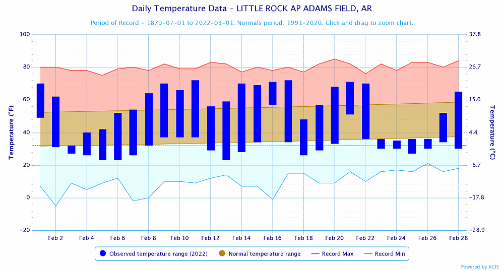 |
| In the picture: Temperatures at Little Rock (Pulaski County). Click to enlarge. |
|
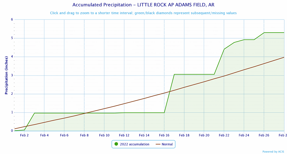 |
| In the picture: Precipitation at Little Rock (Pulaski County). Click to enlarge. |
|
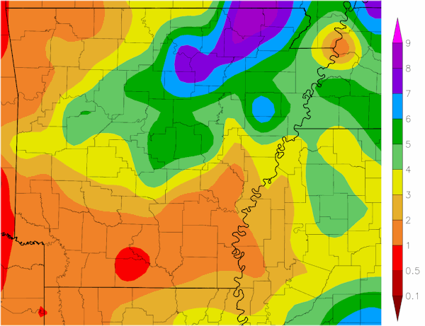 |
| In the picture: Precipitation across Arkansas. |
|
|
|


 Follow us on YouTube